This week will end with a bang! A potent Pacific storm system will blast through the Front Range during the day Friday bringing possible damaging winds, a slight chance of rain/snow, and fresh powder to the High Country.
Calm, cool, and cloudy Thursday
It’s been a relatively quiet 2020 so far. Both Boulder and Denver are yet to see any measurable precipitation, with our last occurring during a light snow event nearly three weeks ago on December 28th. The incoming storm system will be the strongest of the week, something we touched on in our weekly outlook on Monday. The NAM forecast vorticity animation below shows the storm system coming ashore into California Thursday evening then rapidly heading east across Colorado on Friday.
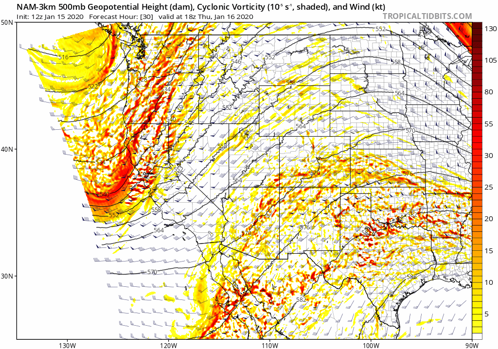
High-resolution NAM 500 mb vorticity forecast animation from Thursday evening into Friday evening showing the approaching storm
Ahead of the approaching trough, the subtropical jet stream is situated over Colorado spreading mid and upper-level moisture into the region.

GFS 250 mb wind forecast for Thursday morning. The subtropical jet is pumping into Colorado
This will make for a very cloudy Thursday in the Metro area, but won’t lead to any precipitation unfortunately. The lower atmosphere remains extremely dry…evidence: the current dew point at BoulderCAST Station is just 11°F.
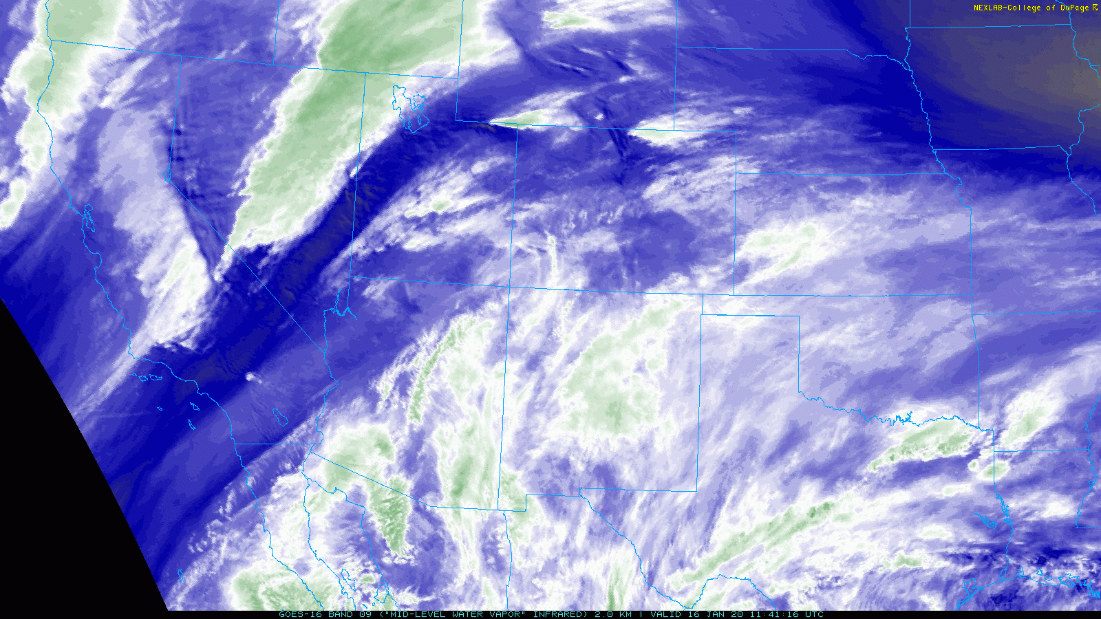
GOES-East satellite animation from Thursday morning showing subtropical moisture and clouds streaming northward into Colorado
Despite the cloud cover, Thursday will be quite mild for portions of the Denver Metro area. It really depends on which side of the Denver Cyclone you end-up on this afternoon. North and west of this line will be chilly in the 30’s to lower 40’s. South and east may reach lower 50’s. In any case, winds will be light on Thursday as a flat and brief ridge of high pressure passes across the central Rockies.
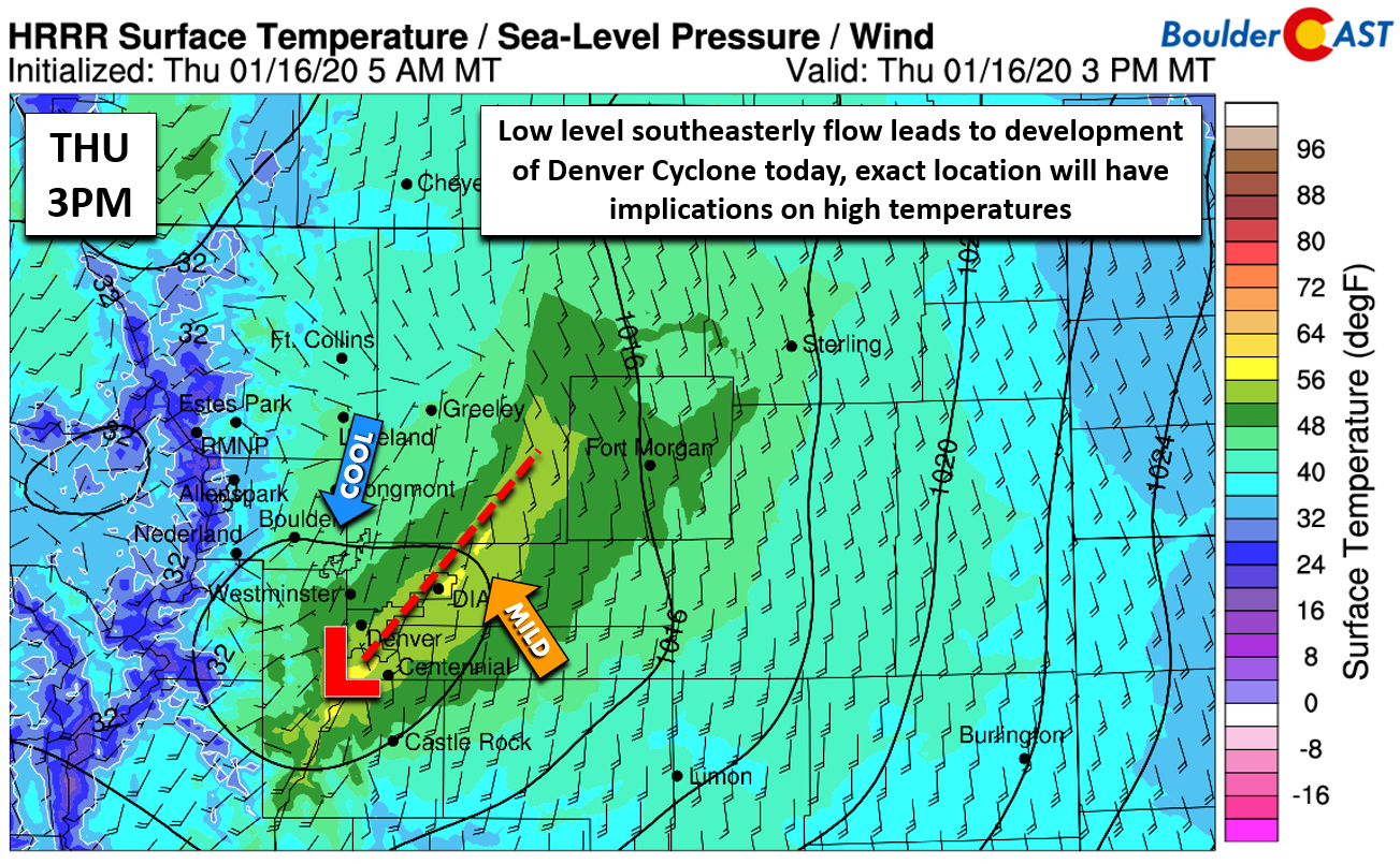
HRRR surface temperature and wind forecast map for Thursday afternoon showing the divisive Denver Cyclone
Things change Friday
The rules of the game change big-time on Friday as the spirited shortwave system enters the picture. The trough and associated Pacific cold front will blow across the Front Range from west to east during the daytime. After a mild morning, the front will pass around mid-day, followed by falling temperatures through the 40’s and into the 30’s by mid-afternoon.
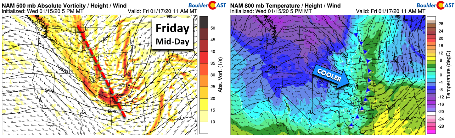
NAM 500 mb vorticity map (left) and 800mb temperature and wind map for mid-day Friday
We’re even monitoring a slight chance of rain changing to snow showers with this front. There are numerous competing factors at play, though, and it doesn’t look good. The swift downslope and low-level dry air will be counteracting concentrated lift from the jet stream and potent trough, as well as added instability from very cold air aloft. We’re even expecting a little bit of rare January convection with up to 200 J/kg of CAPE indicated by a few models. Will this be enough to produce lightning and thunder? Most likely not, but the chance isn’t zero, especially in the Mountains (thundersnow?). If anything, this just speaks to the vigorous nature of the storm system moving through!

HRRR model CAPE forecast for Friday mid-day
The best chance of precipitation in the Denver Metro area will be right around the time the front passes, primarily between 10AM and 2PM Friday. Temperatures will be dropping during this time, so any precipitation will be a mix of rain and snow (no accumulation). Given the convective potential, there could be some graupel thrown into the mix as well. Still, chances are very low overall for anything to reach the ground with the dry surface layer and downslope. We put the odds around 10-20% in the western suburbs like Boulder, but closer to 5-10% for most of Denver. If your area picks up anything more than a few sprinkles or snowflakes, consider yourself lucky!

Total precipitation forecast through Friday night from the GFS (top left), NAM (top right), and HRRR (bottom).
After the front passes and the tiny chances for precipitation wane, our attention turns to a developing Bora wind event across the Front Range and much of northeast Colorado. Bora winds are driven primarily by very cold air aloft pooling over the Mountains, but do require strong pressure differences across the terrain as well. Eventually the front moves through and the dam breaks and all that cold, dense air surges downwards east of the Continental Divide. Unlike Chinook winds, Bora winds are cold and dry, but can be just as intense.
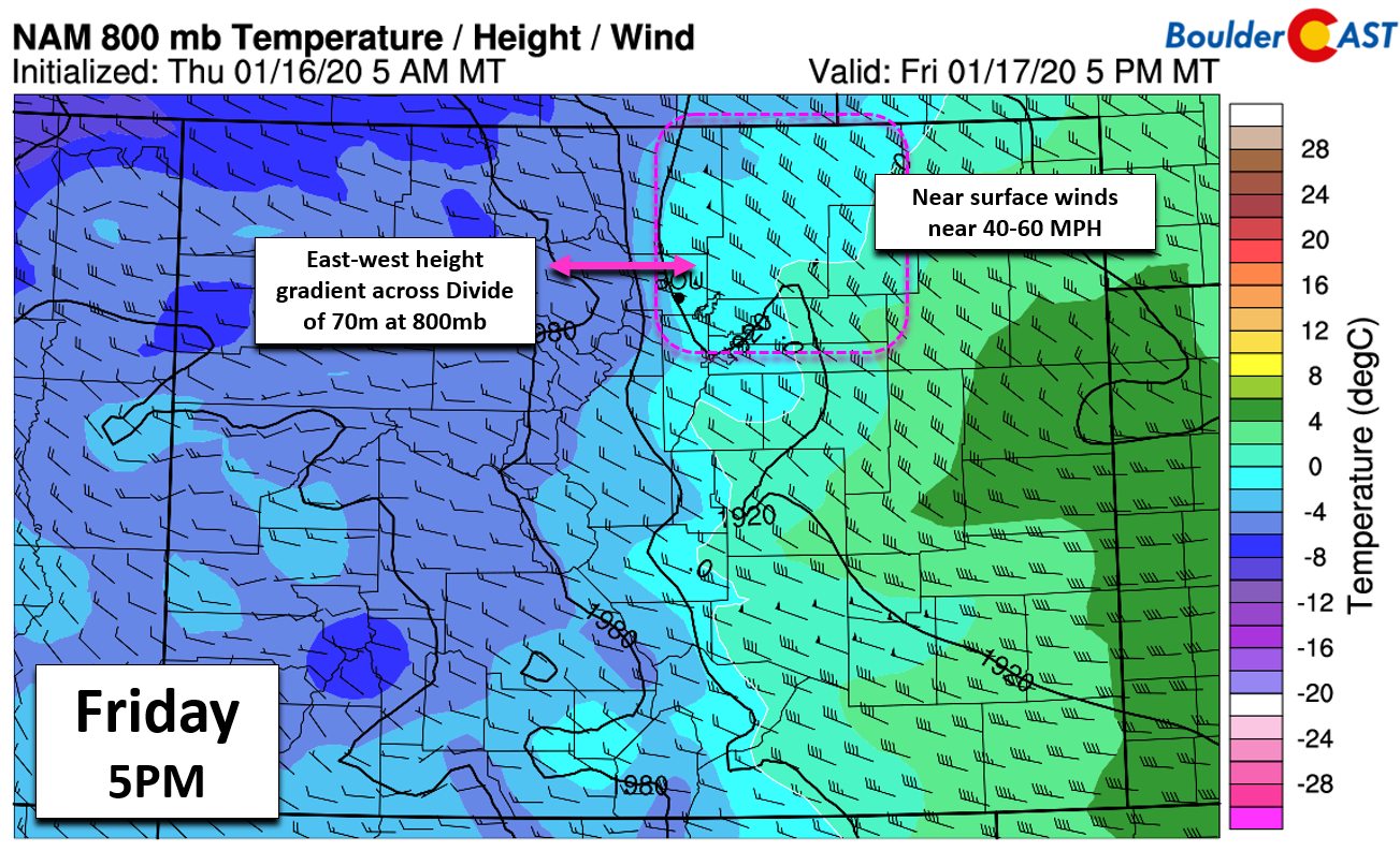
NAM 800mb temperature and wind forecast map for Friday evening
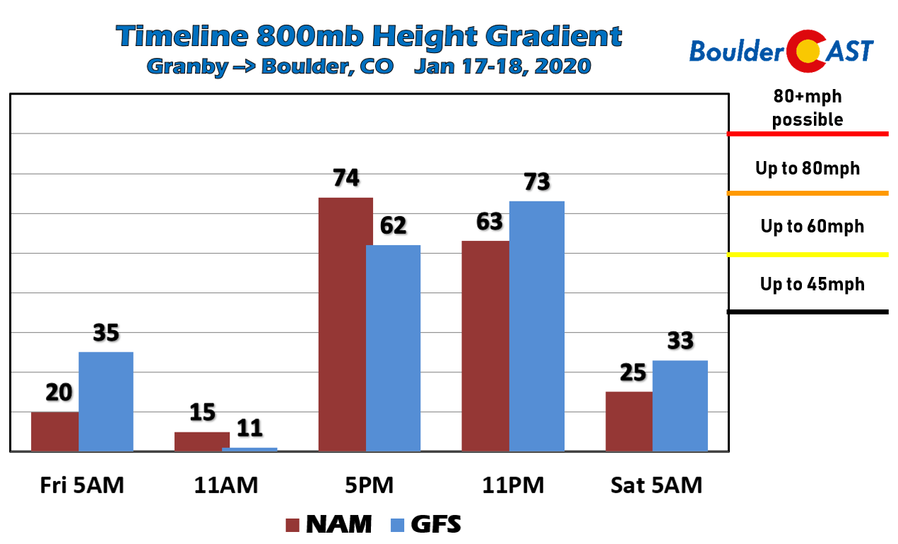
Models are in good agreement for a strong 800 mb height gradient developing Friday afternoon into the evening hours. Both the GFS and NAM models show this gradient cresting above 70 meters between Boulder and Granby. This suggests wind gusts above 60 MPH for the area, possibly even exceeding 80 MPH briefly during the height of the event. Friday will have a very blustery afternoon, evening and overnight. The worst of the winds are likely to occur between 3PM and 10PM, lessening considerably thereafter for most of the lower elevations. Strong winds could linger in and near the Foothills through much of Friday night as the Bora event transitions into a mountain wave.
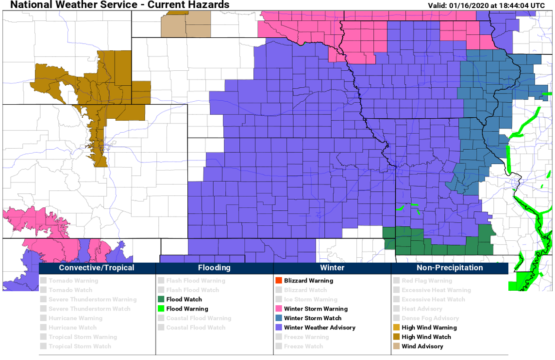
The National Weather Service has posted High Wind Watches for the western suburbs and Foothills during this time. It’s likely these advisories will be extended further east as really all of northeast Colorado is on the chopping block. This will be a widespread strong wind event with downed trees/fences, blowing dust, and power outages possible. As our storm rapidly kicks out across the Great Plains region Friday night into Saturday, it will unleash a fury of wintry weather.
The final facet to this storm worth discussing is snowfall in the Mountains. This is an impressive storm system. It’s a shame that it is moving so rapidly! The window for snowfall in the Mountains will be very brief…just about six to eight hours during the morning and early afternoon Friday. With all of the factors at hand, snowfall rates could be quite intense during this short window, however. Deep subsidence kicks in quickly and will shut down the snow during the afternoon. We’re predicting about 3-7″ above 10,000 feet for the central and northern Mountains. Travel in some of the heavier snow showers during the day Friday could be difficult, especially when considering there will be 50+ MPH winds. If you’re a skier, be sure to take advantage of this powder! Were not seeing any more of it in the pipeline through the middle of next week, perhaps longer.

That’s all for now. Batten down the hatches!
.
We discuss Boulder and Denver weather every single day on BoulderCAST Premium. Sign up today to get access to our daily forecast discussions every morning, complete six-day skiing and hiking forecasts powered by machine learning, access to all our Front Range specific weather models, additional storm updates and much more!

Subscribe to receive email notifications for BoulderCAST updates:
We respect your privacy. You can unsubscribe at any time.
.
Spread the word, share the BoulderCAST forecast!


You must be logged in to post a comment.