As we move towards the tail-end of snow season here in Front Range Colorado, we can’t help but think this winter has been longer, colder, and snowier than years passed. We examine the data to confirm this and discuss the chance for more accumulating snow in the coming weeks.
I
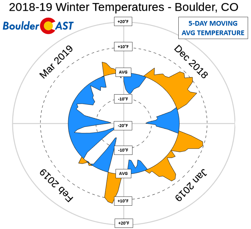
t is clear that there is an overwhelming feeling going around that this winter was particularly long and cold. On-paper, however, this isn’t necessarily the case. Sure, February and March were notably colder than normal, but both December and January saw lengthy periods of above normal temperatures.
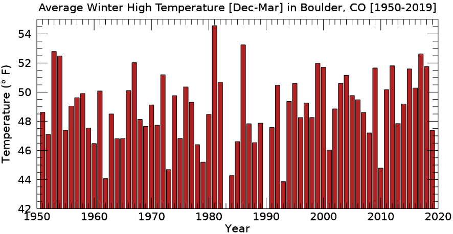
Looking at the entire four month period from December to March, this winter had the 18th coldest average high temperature in Boulder since 1950 at 47.4°F (and the coldest since 2010). This is definitely below normal, but not remarkably so.
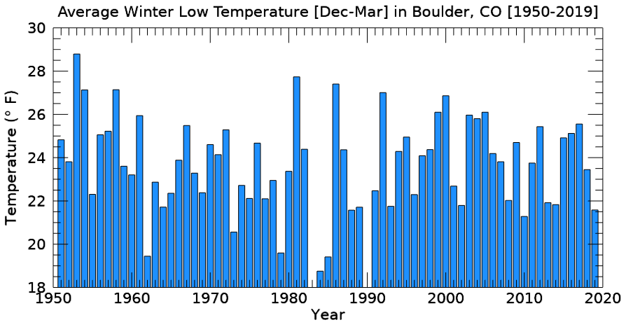
Average overnight lows were a little chillier, the 7th coldest since 1950 at 21.6°F (and the coldest since 2010).
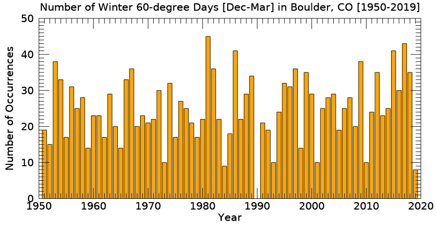
The aspect of this winter that stood out most to us was the distinct lack of unseasonably warm Front Range winter days. We had been trying to get some outdoor painting done all winter long, but Mother Nature just wouldn’t cooperate. This intuition is confirmed if we look at the data. This winter had the lowest number of 60+ degree days on-record (since 1950), a total of only eight between December 1st and March 31st. Even worse, half of those eight days occurred in the last week of March!
If we examine the distributions of winter high and low temperatures in Boulder since 1990 (below), we see that this winter had fairly “typical” curves. The exception to this is the right tail of the high temperature distribution, which is essentially non-existent cutting off sharply at 60 degrees. No other year has this type of pattern…but the winter of 2009-10 was close.
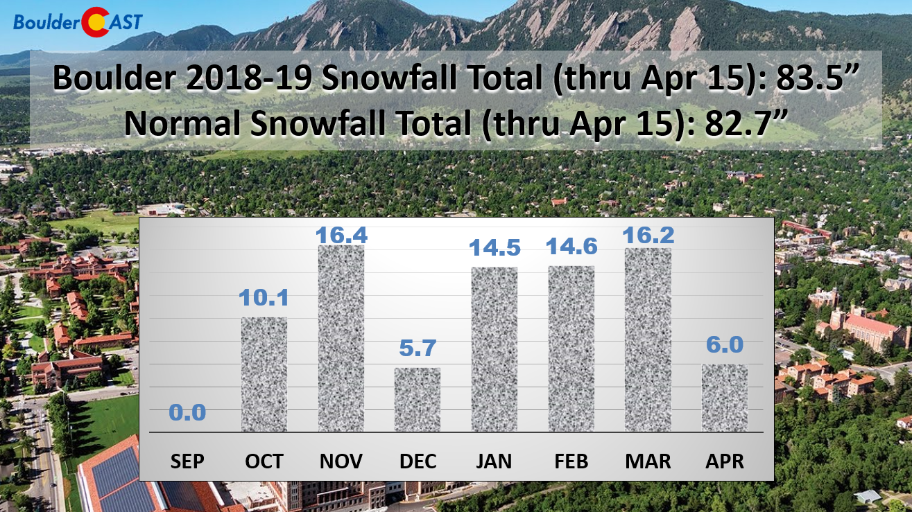
Snowfall has not been out of ordinary this winter either. Through April 15th, Boulder has seen 83.5 inches of snow. This is less than one inch above normal for this time of year. The snow was relatively well-distributed throughout the entire winter, with each individual month recording totals within a few inches of normal. The only outlier was December, where only 5.7 inches of snow fell, the lowest amount since 2002.
If anything, this winter may have seemed a little snowier due to the sheer number of snow events. There has been 19 different storms for which we created a snowfall forecast map (and a handful that we didn’t), more than any other winter season since the founding of BoulderCAST in early 2015. With the exception of the 14-incher on November 11-12, most of the snowstorms this winter have been rather minor in Boulder (1 to 6 inches). This high frequency of low impact snow events is actually more common during a La Niña winter, not during El Niño like we are in now.
Mountain snowfall has been extraordinary this year, however. There’s no questioning that! Drought has been nearly eradicated from the state, which is unbelievable considering how desperate things were just one year ago (heck, even six months ago).
So it seems the combination of frequent small snow events for the Metro area, the lack of truly warm winter days, and prolific mountain snow have made this winter seem worse than it actually was. To us, this winter felt more like a “normal” Colorado winter than any of the last five years. The media likes to proclaim that “dry and warm” is the new normal for Colorado winters. Let’s hope this isn’t the case and that this winter’s theme carries over to next.
For more specific information, check out our summary pages for the last few winter seasons:
Are you tired of the snow yet? We sure hope not!
April and May are the two wettest and gloomiest months of the year for northern Colorado. In fact, nearly a third of our annual precipitation falls during these two months alone. This is a result of the brief but vital overlap between a favorable storm track and increased atmospheric moisture content. Occasionally, a little bit of cold air lingering from the winter season can fold into the mix, producing heavy spring snow for the Foothills, and sometimes even the Plains. Just about anything can happen this time of year, including severe storms, flooding, and crippling snow storms.
The chart below shows the date of Boulder’s last measurable snowfall for each year dating back to 1950 (blue snowflake icons). By measurable, we mean that officially 0.1″ or more of snow was recorded. As is often the case late in the snow season, a few flakes mix in with rain, or flurries briefly fly, but never stick on the ground. These are instances where a trace of snow has occurred, but wasn’t measurable. Trace snow amounts are not included in this graph.
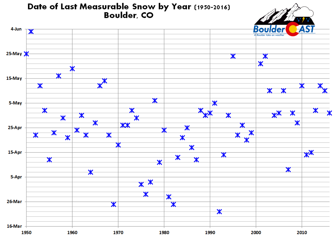
The date of Boulder’s last accumulating snowfall varies from mid-March to early June (yes, it has snowed in June before!). The median date is still more than ten days away on April 26th. The latest date ever, June 3rd, confirms for us that snow is still possible in Boulder for SEVEN more weeks!
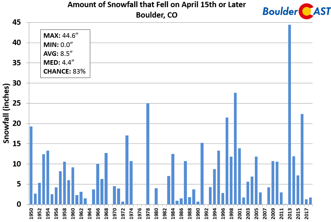
Since 1950, the median amount of snowfall after April 15th is 4.4″. The most snow ever to occur after today’s date was 45″ back in 2013. Can you imagine if we still had nearly four feet of snow to come?!?
Will we escape late-season spring snow this year? It’s too early to tell. According to climatology, there’s still a relatively high chance that Boulder will see snow again this season…somewhere around 83% as of today. However, the weather models are a lot less optimistic, at least in the near-term. There is essentially no chance of snow the rest of this week, and even in the extended, few if any model solutions show cold enough air for snow across the lower elevations.
Take our poll below and tell us why you’re looking forward to summer– or not, in the comments!
.
Share this post:
.







You must be logged in to post a comment.