A prolonged period of light to moderate snow fell across most of the Denver Metro area Tuesday evening into Wednesday evening. We briefly review the booming snowfall totals from the first real dump of snow in the nascent 2024-25 season!
T
his forecast was a challenging one, with models sharply trending upward in the final hours on Tuesday as the “feared” slower and more northern track took shape overnight with the parent storm system in Utah and SW Colorado. At the last moment, it studently started to become clear that the higher-end solutions were favored by most modeling suites. Some were even showing 10-20″ through all of Denver. Given the trend, we bumped up our forecast considerably but in the end it still wasn’t enough in many areas.
Snowflakes are flying already, but we're still mulling over the bonkers model output coming in this evening regarding our snow potential over the next 36 hours. Things are clearly trending up. Most likely scenario is still probably 2-6" in the Metro area, highest south. BUT… pic.twitter.com/vKUCMOzfbT
— BoulderCAST Weather 🏔️❄️ (@BoulderCAST) November 6, 2024
The National Weather Service toiled in the same dilemma, not even adding Boulder and Denver into an Advisory until late Tuesday evening after several inches of snow had already fallen. In reality, a Winter Storm Warning would have been more applicable to the outcome.
Winter Weather Advisory was just issued for Boulder and Denver for…..2 to 9 inches of snow
Who's hoping to be on the 9 inch end of that range? 😆 #COWx pic.twitter.com/RSbl1W5L46
— BoulderCAST Weather 🏔️❄️ (@BoulderCAST) November 6, 2024
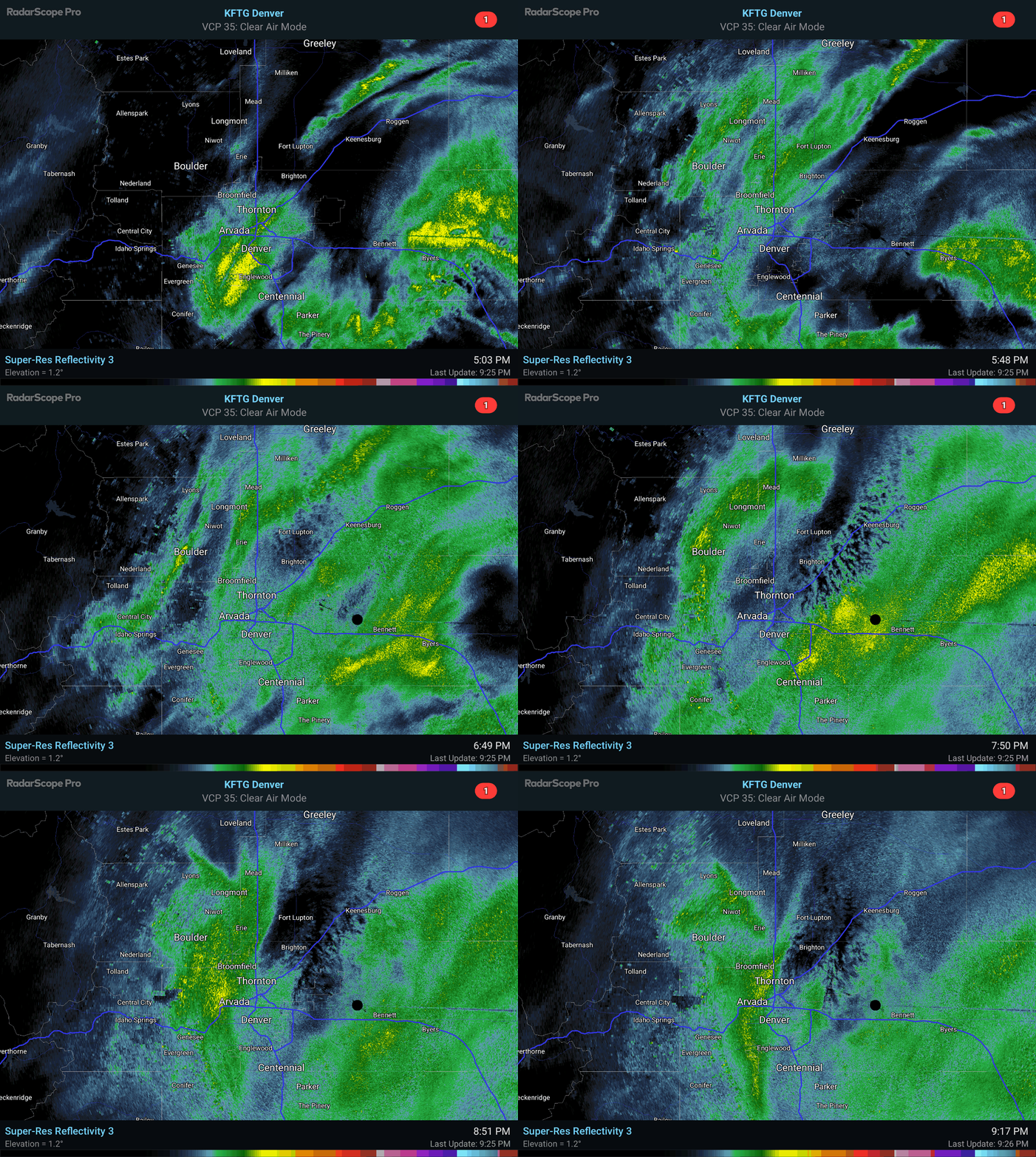
Bands of snowfall began earlier and harder than expected Tuesday evening, with many areas seeing 1-4″ of snow within just the first few hours of the event. For example, Boulder received close to 4″ of wet snow before midnight thanks to a heavier band that lingered over the city for a couple hours. The radar animation below shows the onset of the snow Tuesday evening.
Snow continued for ~24 hours straight in most areas, at times dumping up to 2″ per hour in parts of the Jefferson County Foothills on Wednesday. Snow slowly dissipated Wednesday evening across the area.
NNE flow absolutely pummeling this area still this morning. May see some 20+" totals by the time snow stops tonight in the foothills of Jefferson County #cowx pic.twitter.com/IYXtmKQxaf
— BoulderCAST Weather 🏔️❄️ (@BoulderCAST) November 6, 2024
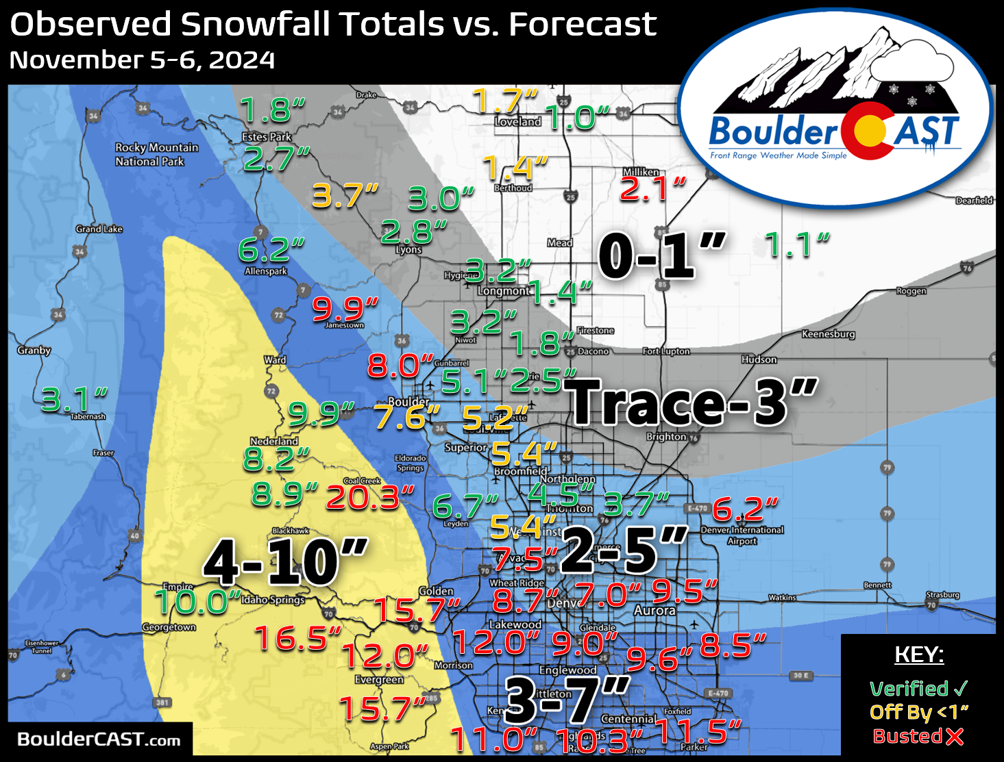
Our snowfall forecast map issued Tuesday early evening is shown below with storm totals overlaid. Green values indicate our forecast verified, Yellow values mean the observed total was just outside our forecast, while Red was a busted forecast (more than 1″ off). Booming snowfall was observed across a large portion of the region. Totals up to 20″ occured in the Foothills of Jefferson County, with up to 12″ in parts of the southern Denver area. 2-8″ fell in eastern Boulder County. We knew this would be a tough forecast with a sharp north-south gradient in snow totals — that’s exactly what we got!
Officially, Boulder received 7.6″ of new snow from this weekend’s storm, while Denver (DIA) recorded 6.2″. The snow season is off to a slow start, but that appears to be changing this week…
| Seasonal Snow Totals (Updated November 7 2024) |
|---|
| Boulder | Denver |
|---|---|
| 7.8" | 6.2" |
You can find a recap of all the winter storms so far in the 2024-2025 snow season HERE.


You must be logged in to post a comment.