Premium Storm Update (Thu Mar 15 at 12:30 PM) A wetter evening than expected? We provide a brief storm update as the latest round of models bring heavier precipitation slightly further south.. READ NOW
—
A quick-hitting storm system will provide the brief chance of rain, snow, and thunder to the region Thursday afternoon and evening. Read on as we detail the storm specifics.
In our weekly outlook on Monday, we tried to stress the uncertainty surrounding the weather towards the end of the week. The guess-work lies in the interaction between a powerful but disorganized trough across California and an amplified ridge across the Great Plains. Think of this scenario as the front-lines of a early 20th century war between two great armies. We knew the general area where the opposing sides would clash, but the specifics on when, where, and how strong each offensive attack from the trough would be was impossible to predict.
For example, you can see how the forecast from the GFS model changed over the last three days in the diagrams below. Back on Sunday, the model was predicting weak and disorganized energy across Colorado and Utah for Thursday evening (left image below). However, as you can see on the right, the wave approaching Colorado is much more pronounced now. This will ultimately help to bring a slightly better chance of precipitation than it looked earlier in the week for our region. Still, chances will remain limited at that.
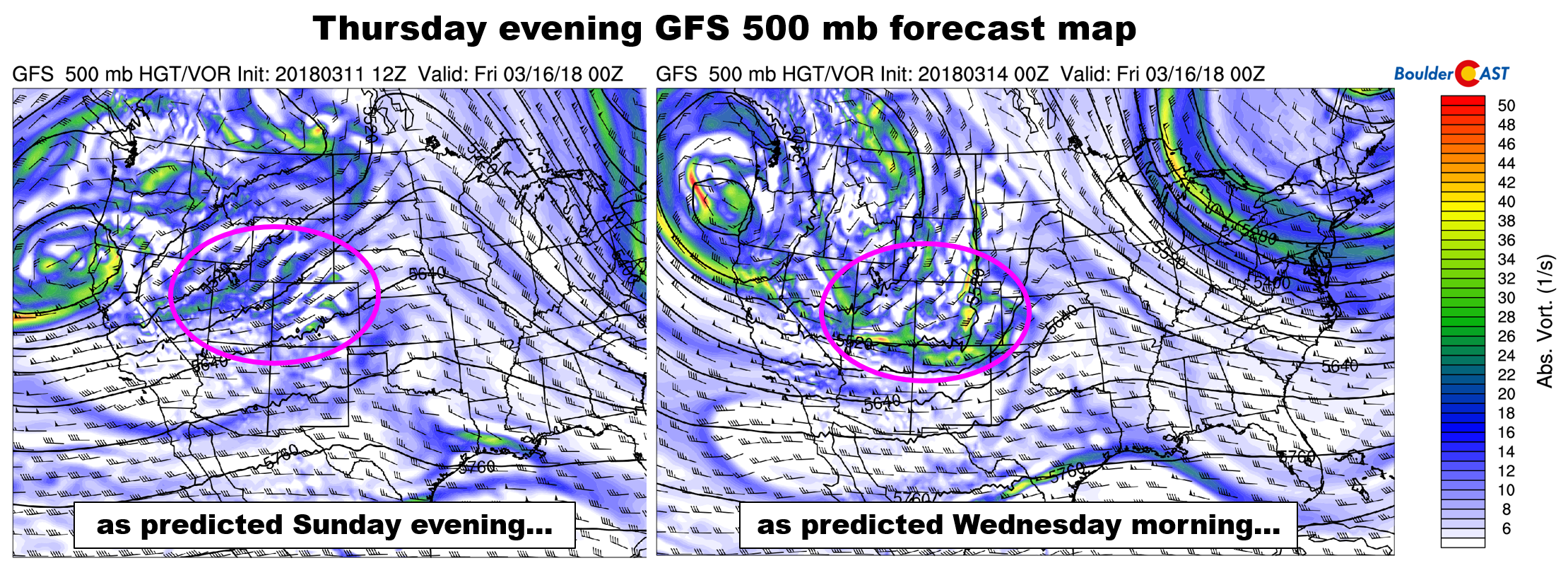
GFS 500 mb vorticity forecast maps for Thursday evening. The one of the left was from the model initialized on Sunday. The one on the right is from Wednesday morning.
As of Wednesday morning, the forecast for the next 72 hours is coming into focus. As the upper-level disturbance moves across the state, a surface low is expected to form in east-central Colorado near the Kansas border Thursday evening. This will help produce a brief wave of precipitation across the Front Range during this time, and draw cooler air southward into northeast Colorado.
Thanks to the merger of the polar and subtropical jet streams across the Four Corners region, the atmosphere will be juicy over the next few days, at least by “middle of March” standards.
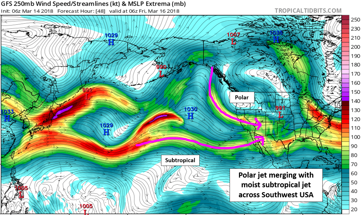
GFS 250 mb wind map for Thursday night. The polar jet and subtropical jet are merging across the southwestern United States.
As you can see in the precipitable water forecast map below, there is a pipeline of moisture stretching all the way from Hawaii into Colorado. It looks a lot like an atmospheric river, but the moisture content isn’t nearly high enough to be “official”. Nonetheless, models do show precipitable water values pushing towards 0.6″ across the Metro area by Thursday evening. Admittedly, some of this is getting wrapped in from the Gulf of Mexico in the low-levels as well.
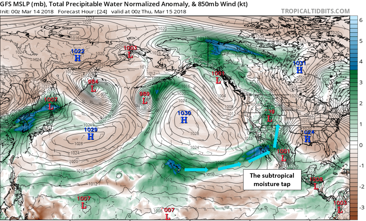
GFS precipitable water anomaly map for Wednesday evening. A long fetch of moisture is funneling into the Four Corners region.
The trough offshore to California has been relatively stationary for the last few days. This has produced an extended period of southerly winds to the southwestern United States through the week. Not only has this advected in moisture, but it has allowed warm air to push northward through a deep layer of the atmosphere. If it wasn’t for a wealth of cloud cover and precipitation, many areas across Colorado may have been looking at record highs today and tomorrow.
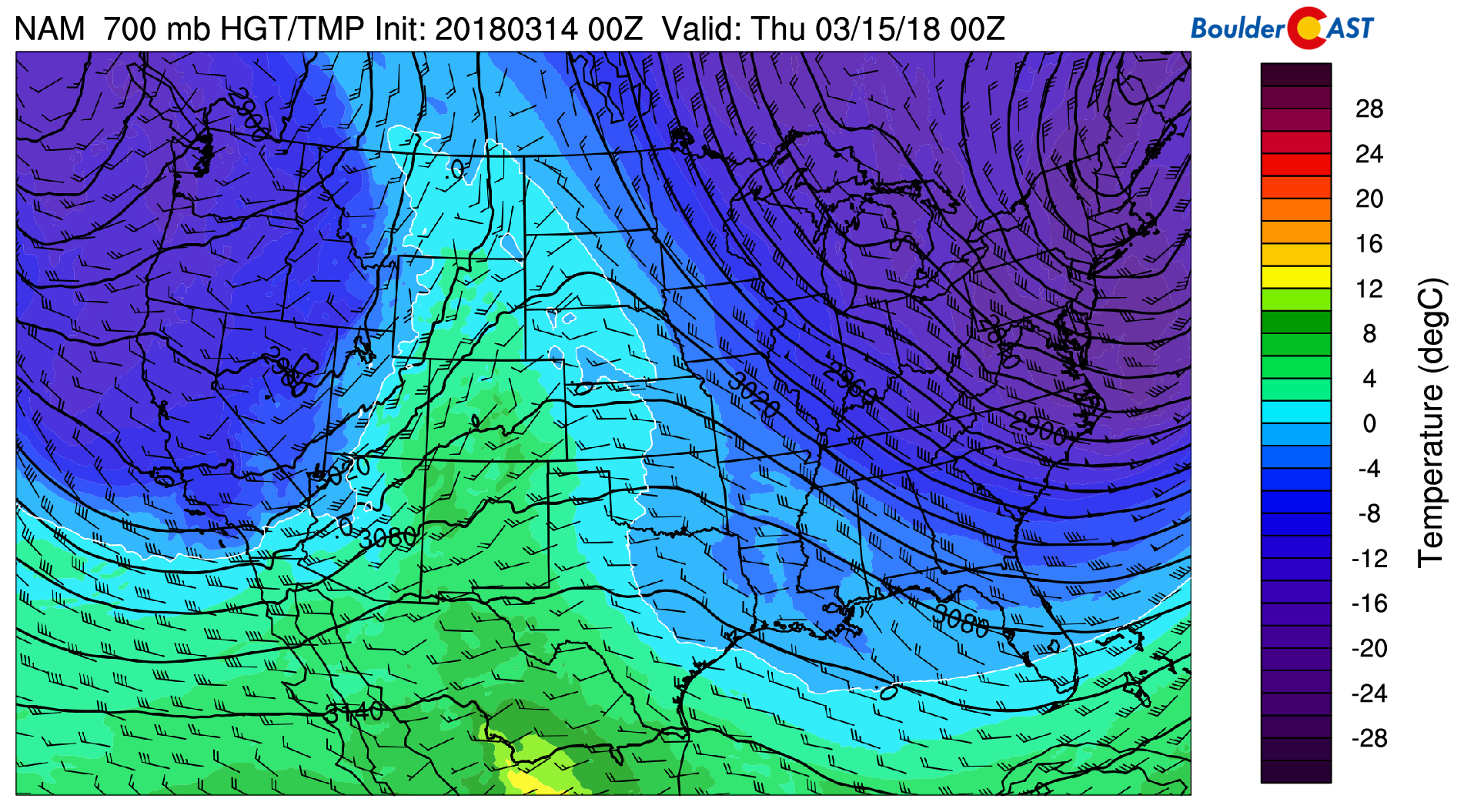
NAM 700 mb temperatures for Wednesday afternoon. Values of +5 Celsius are apparent across parts of Colorado.
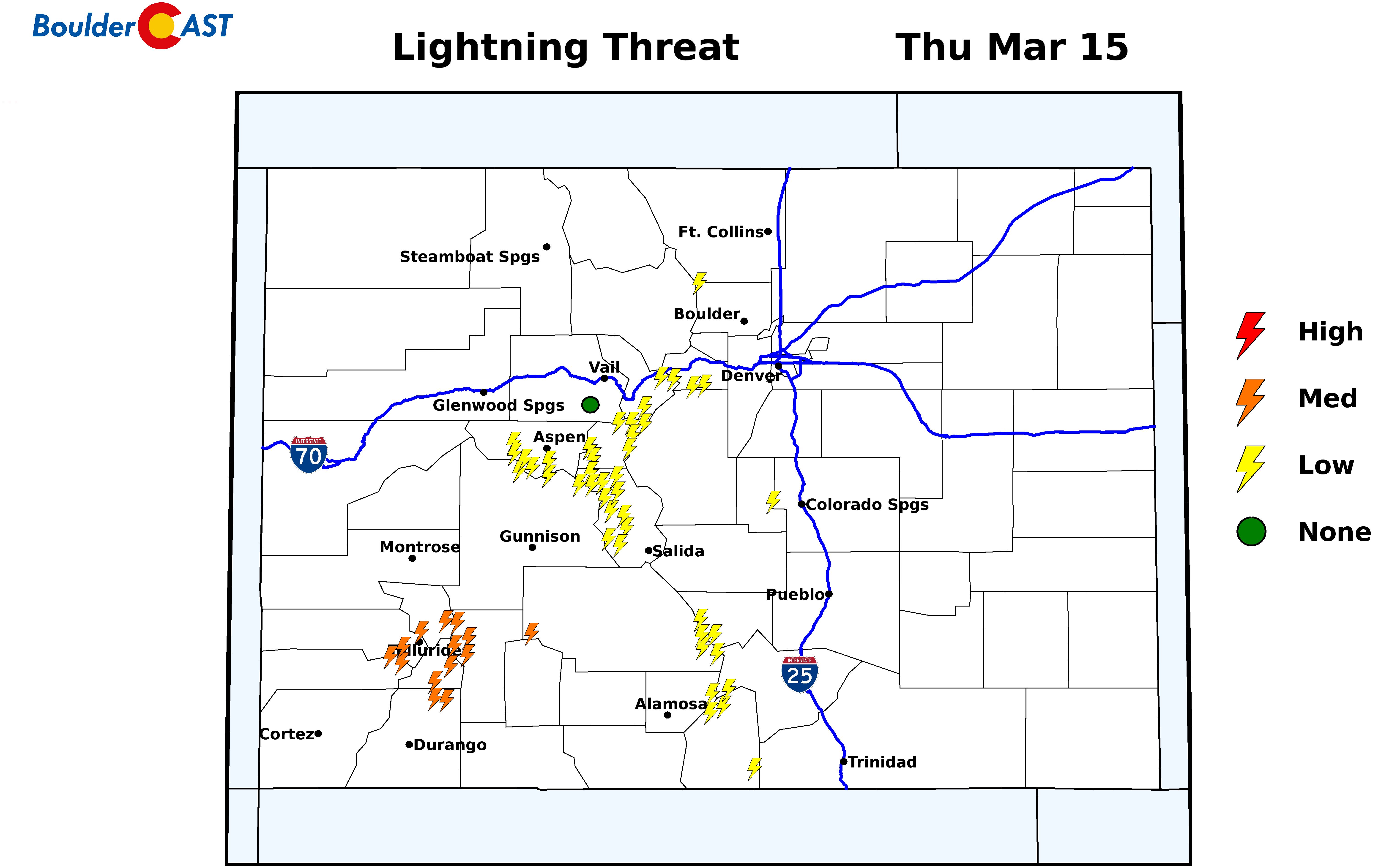
For the first half of Thursday, we’ll remain in the warm sector of the storm system. Highs early-on will reach into the low 60’s, with isolated to widely scattered showers developing during the late afternoon into the evening. The warm juicy air could fuel a few thunderstorms as well during this time. The dynamics look really good overall. However, recent model trends show extensive cloud cover across the region. This may ultimately limit solar heating and curb our chances of forming deeper convection and any lightning. SummitCAST is showing a decent potential for thunderstorms over the higher elevations, particularly in southwestern Colorado.
The most likely timeframe for precipitation in the Metro area will be 3PM to midnight on Thursday. Precipitation is not expected to be widespread, but instead localized and somewhat banded in nature. Locations that do land under a heavier cell or two could see more than 0.25″ of rain, whereas some locations may only receive a few drops or nothing at all.
Snow levels across the Front Range will initially be quite high, around 9,500 feet elevation Thursday afternoon. They will be falling quickly through the day, however…possibly reaching down to 6,000 feet after sunset. By that time, though, northwesterly downslope will be taking over with precipitation generally winding down.
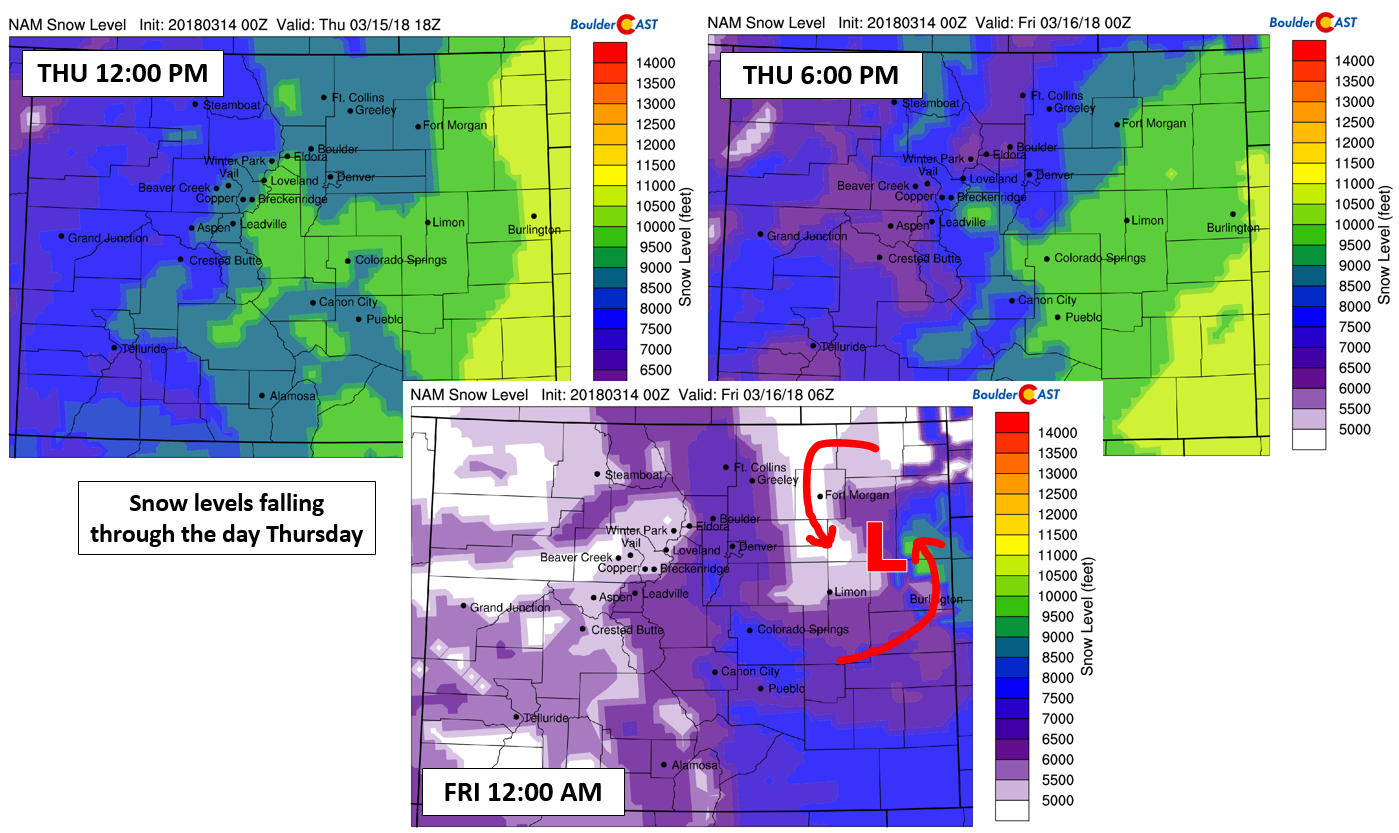
NAM model-derived snow level forecast through the day Thursday. Snow levels are expected to drop from 9,500 feet to 6,000 feet. The surface low pressure out near the Kansas border will draw cold air southward to turn rain to snow on the Plains near the Wyoming and Nebraska borders Thursday night.
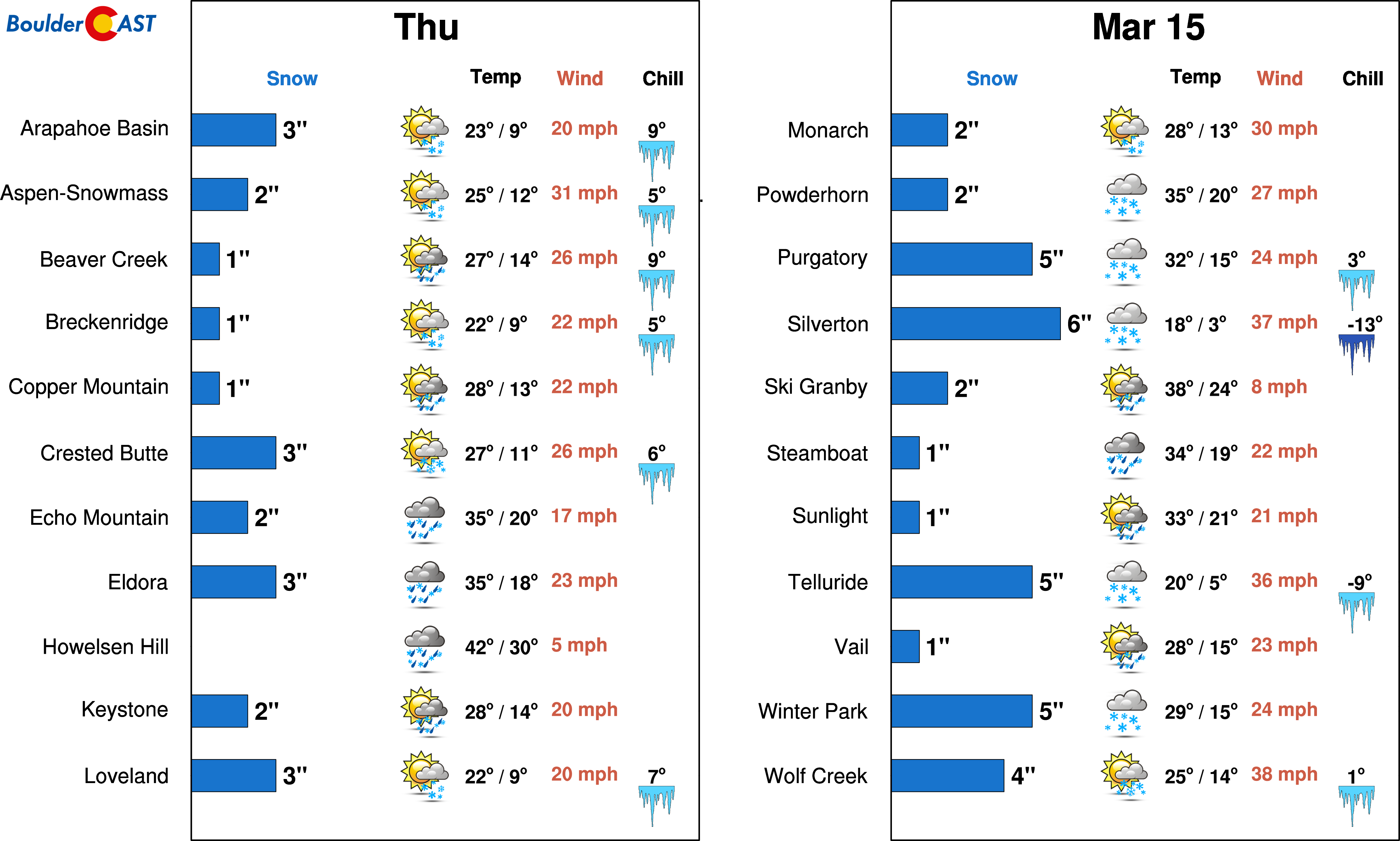
What does this all mean? For the lower elevations, this means precipitation will fall mainly in the form of rain. There is a slight chance of a few snowflakes mixing in with some of the heavier showers, but no more than a quick dusting would be expected in these isolated spots. In the Foothills, especially the higher areas above 8,000 feet in Larimer and northern Boulder Counties, a couple of inches of slush are possible as the convective showers pass through Thursday evening. Keep in mind, this will be hit-or-miss as well. The Mountains are also looking at 2 to 6″ of snow from this event, with localized areas seeing closer to 8″.
Temperatures will fall into the low to middle 30’s on the Plains by Friday morning. With drier air filtering in, sunshine and mild temperatures in the 50’s are expected on Friday and Saturday. Blustery northwest winds will around during the day Friday, with gusts at times exceeding 35 mph area-wide.
Overall, not a major storm to our region. This will be our first chance at measurable precipitation in nearly three weeks. For the very same reason as Thursday’s storm, uncertainty remains high regarding another potential weather-maker towards the latter half of the weekend. We may share more on this later….
Gift this forecast:
.



You must be logged in to post a comment.