
Widespread rain showers will develop through the day Wednesday and turn to snow Wednesday night for everyone. We discuss the timeline of the storm and provide our snowfall forecast map. When will winter end?
Help support our team of local meteorologists, get expert Front Range weather analysis from us every single day and access all our forecast content with BoulderCAST Premium.
Now through May 9th, join and save 25% with promo code SNOW.

ur two storm systems are coming together nicely across Colorado this morning. You can see both in the GOES-East water vapor animation below. One system is located across southeastern Colorado, while a second is sitting over central Utah. These two storms will stall across the state for the next day or so making for a very soggy next 36 hours. After this, the warmer eastern disturbance will move out into the Upper Midwest while the colder Utah-area storm will defer westward into southern California as a cut-off low.
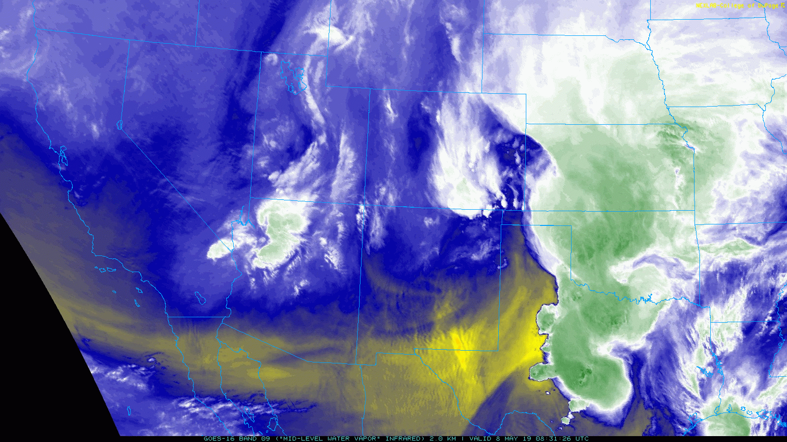
GOES water vapor animation from Wednesday morning
Temperatures as of Wednesday morning are in the middle 40’s across the lower elevations, with 30’s in the Foothills. A cold front pushed through the Denver Metro area overnight, but the colder air to the north is slower to follow. North and northeasterly winds will advect this chillier air southward through the day, with temperatures slowly dropping through the morning and afternoon into the 30’s across the Plains as well. Temperatures will eventually dip into the lower 30’s tonight (20’s in the Foothills).
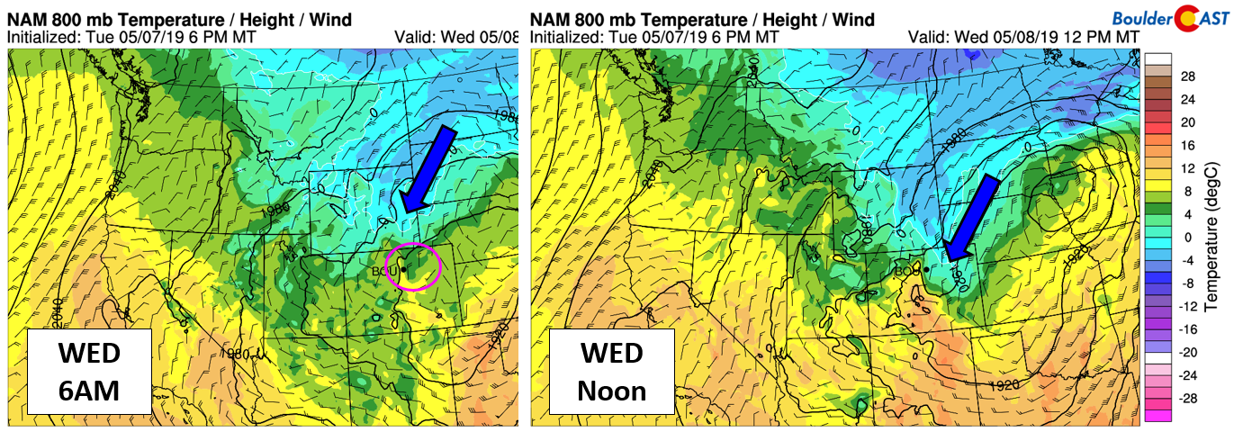
NAM near-surface temperature and wind forecast for Wednesday morning (left) and at mid-day (right)
The primary amendment we need to make to the forecast today is to bring forward the change-over timing of rain to snow this evening across the Plains. The overall trend in the models has been earlier with the colder air, transitioning rain to snow for most of us between 8:00 PM and midnight Wednesday evening. Accumulating snow is generally only possible at night this time of year due to the very strong May sun. Remember, we’re only about six weeks from the summer solstice today! As a result, our forecast now includes a LONGER period of night-time snowfall for the Metro area which should allow for slushy accumulation for everyone by Thursday morning.

NAM model-derived snow level forecast for midnight Wednesday night
Storm Timeline
- As upslope flow intensifies Wednesday morning and afternoon, rain showers will become more widespread across the Metro area. Boulder in particular is in for the long haul, with near-continuous precipitation lasting for 24 hours, if not 36 hours
- Cooler air filtering in through the day Wednesday will slowly lower snow levels, from near 8000 feet Wednesday morning down to near 6500 feet by 6:00PM, then they lower further to include the entire Metro area before midnight
- Snow continues through the overnight hours into Thursday morning with most of the accumulating snow occurring before the strong May sun rises again
- Wet snow or a rain/snow mix will linger into Thursday afternoon (or evening), especially in and near the Foothills. Little to no additional accumulation is expected during the daytime hours, but Thursday will be a gloomy, raw day overall.

NAM precipitation forecast for Thursday morning. Snow for all!
Snow Amounts & Impacts
The air is plenty cold enough for snow and the most intense portion of the storm will pass over the region during the overnight hours. However, there is only about an 8 to 12 hour window for accumulating snow. Essentially, that window only exists when the sun is very low in the sky or down entirely. We also have to consider the moisture availability this time of year…it is much higher than mid-winter. We could easily see pockets of snowfall rates hitting 1/2″ to 1″ per hour overnight tonight. The combination of spring and winter elements always make these (very) late-season snow events a challenging forecast!
With that said, we definitely think most areas will see accumulating snow by Thursday morning. Amounts are likely to be greatest the further west you go in the Metro area due to the upslope focus. Furthermore, due to marginal near-freezing temperatures, localized elevation variations will play into accumulation as well, with high points actually dropping below freezing and curbing melting. If you’re near the base of the Foothills and on a local hilltop, you’ll probably see several inches of accumulation tonight!
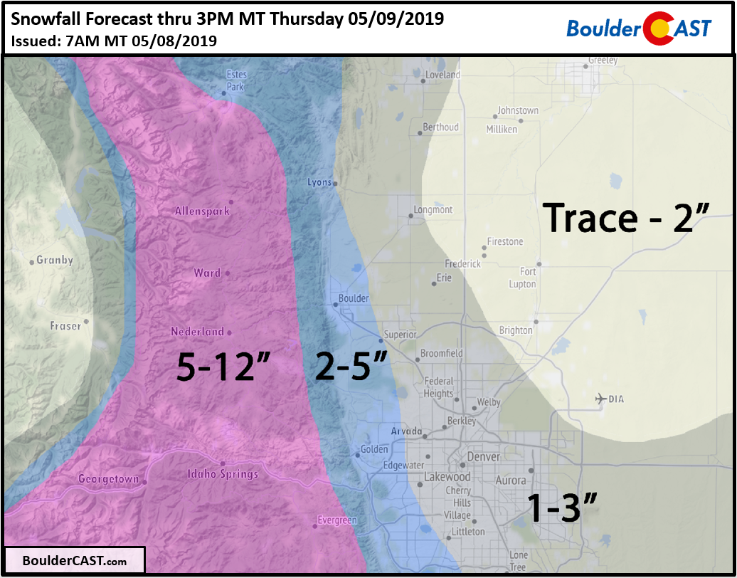
Here’s our snowfall forecast map for the event:
Again we stress that most of this accumulation for the Plains will occur before 8AM Thursday and mainly on grassy/elevated surfaces, with the May sun limiting accumulation after that time, even if light snow continues and/or mixes back with rain. Colder temperatures in the Foothills may allow for additional light accumulations during the day Thursday, but travel should improve with roads melting off quickly.

Ensemble-derived snowfall probabilities for the event. A very good chance of 1″ of snow, dropping off from there, especially in Denver.
We also have some concern about heavy wet snow sticking to leafed-out trees. Won’t the trees ever learn their lesson? Only if snow amounts approach the upper-end of our forecast will this concern become an issue (5 inches of snow or more). This is most likely (but still not that likely) to happen in the far western suburbs, in areas such as Boulder, Golden, and Littleton. Most lower elevation accumulations will be too small to cause any real trouble.
As temperatures cool again Thursday night, we may see yet another wave of light snow across the region. At this time, it doesn’t look nearly as pronounced as Wednesday night’s offering, with any accumulations likely less than 1″.
Hopefully Mother Nature knows most of us plant our gardens Mother’s Day weekend. This needs to be the last of the wintry weather!
P.S. For those of you participating in or attending CU’s commencement on Thursday…dress warm, definitely take an umbrella or poncho, and best of luck in your future endeavors!
Help support our team of local meteorologists, get expert Front Range weather analysis from us every single day and access all our forecast content with BoulderCAST Premium.
Now through May 9th, join and save 25% with promo code SNOW.
Share the BoulderCAST forecast:
.


You must be logged in to post a comment.