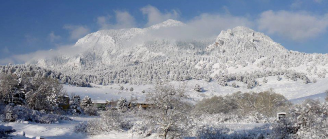
STORM UPDATE (Sunday 9:00 AM): Totals through 9:00AM are 3-5″ across the Plains and 4-6″ in the Foothills. Everything looks on track. Snowfall rates will be heaviest before noon today (up to 3/4″ per hour), with snow tapering off this afternoon from northwest to southeast as winds shift to downslope. Additional accumulations of 1-4″ are possible.
The impending winter storm is tracking slightly slower than the weather models were advertising yesterday. The impacts are good, if you like snow that is! We provide our final forecast, including timing, impacts, and our snowfall forecast map!
As of 10:00 AM Saturday, the upper-level disturbance is located over western Nevada. The water-vapor animation below shows the storm approaching Colorado. The system has not fully cut-off yet, so it’s tricky to locate the circulation. Hint: Look along the California/Nevada border.
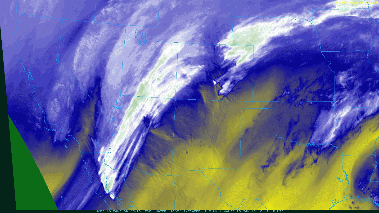
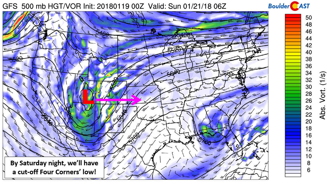
The low pressure is staged to intensify and track across the Colorado/New Mexico state-line on Sunday.
The major aspects in the forecast for the storm remain unchanged this morning. If you didn’t get a chance to read our update yesterday, now would be a great time as that post has more in-depth analysis of the atmospheric components at play. Here’s a handy link:
SLOW DOWN!
The only adjustments needed to our forecast this morning are due to an overall slowing of the storm system. This has been a trend we have observed all week in the models, so it’s not surprising that this is the case…
The net result of this slowing will generally lean towards more impactful winter weather across the Metro area. Here are the notable changes:
- With the storm arriving later, there will likely be a period of freezing drizzle near the onset on the precipitation. We should see things change over to all snow between 2:00 AM and 5:00 AM Sunday morning.
- The storm will linger longer and transition slower. This will translate to a longer duration of snowfall. Yesterday we expected the storm to wrap-up early Sunday afternoon. Now it appears snow will hold strong into the evening hours.
Our final forecast follows….
TIMING:
Sunshine Saturday morning will give way to cloud cover through the day. Ahead of the storm, we’ll be mild in the mid to upper 40’s around mid-day, with cooler air working in through the afternoon and evening. The coldest stuff won’t arrive until after 8:00PM, with temperatures falling into the 20’s overnight.
The lower atmosphere will slowly be moistening up this evening, lending to patchy freezing drizzle below 6,500 feet elevation before the strongest lift arrives early Sunday morning. The mechanism for this icing is similar to what happened on Martin Luther King Jr. Day. This could create dangerous travel conditions late Saturday night.
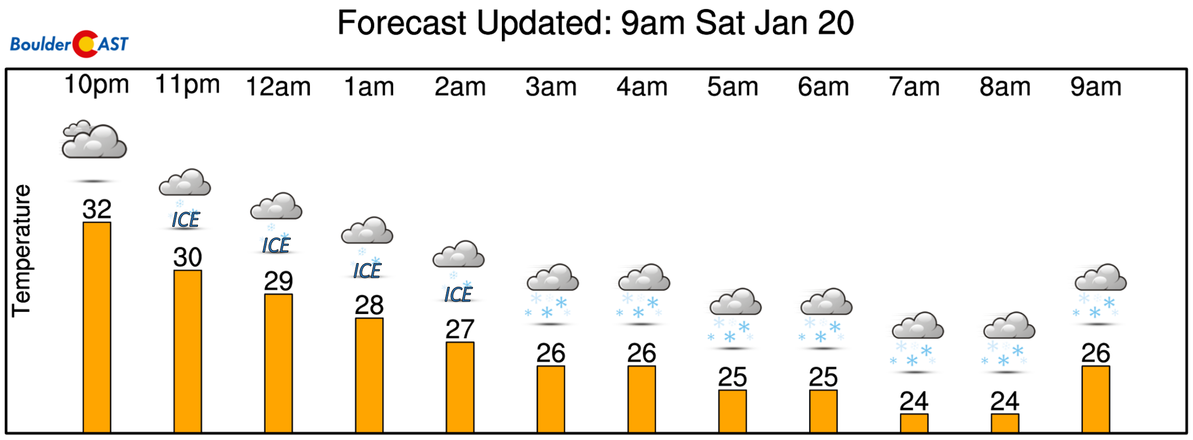
As the pieces of our snowstorm fall into place tonight, we expect a quick change-over to all snow to occur from west to east between 2:00 AM and 5:00 AM. After this point, snow will continue into Sunday evening. The heaviest of it will fall during the morning hours on Sunday, with snowfall rates reaching 1″ per hour. This is the time-frame with the most favorable upslope and upper-level dynamics. Travel will be tricky during the morning and day on Sunday, but should improve in time for the Monday morning commute as the storm system pulls eastward into Kansas. Temperatures Sunday will remain in the 20’s.
SNOWFALL AMOUNTS:
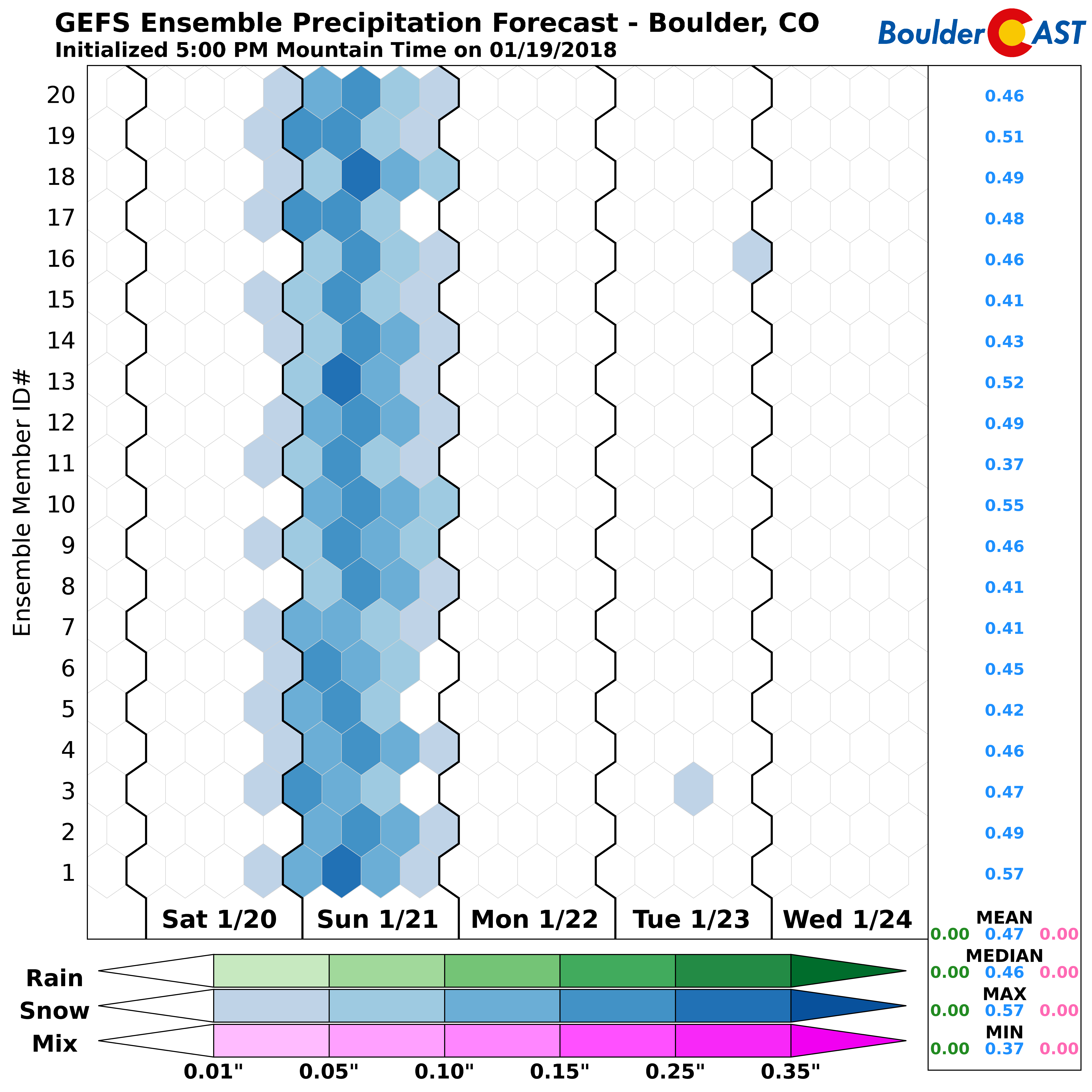
There is good model agreement for 0.3 to 0.6″ of liquid across the Metro area. The GEFS ensemble median and mean are around 0.45″ in Boulder (see below), and not much different in Denver. This consistency is present in the Euro, NAM, and Canadian models as well. We have moderate to high confidence in the forecast.
We’re expecting snow ratios for this event across the Plains to be 13:1 to 15:1. Given this, snow totals WILL be the largest so far this winter in many locations from this storm.
We are forecasting:
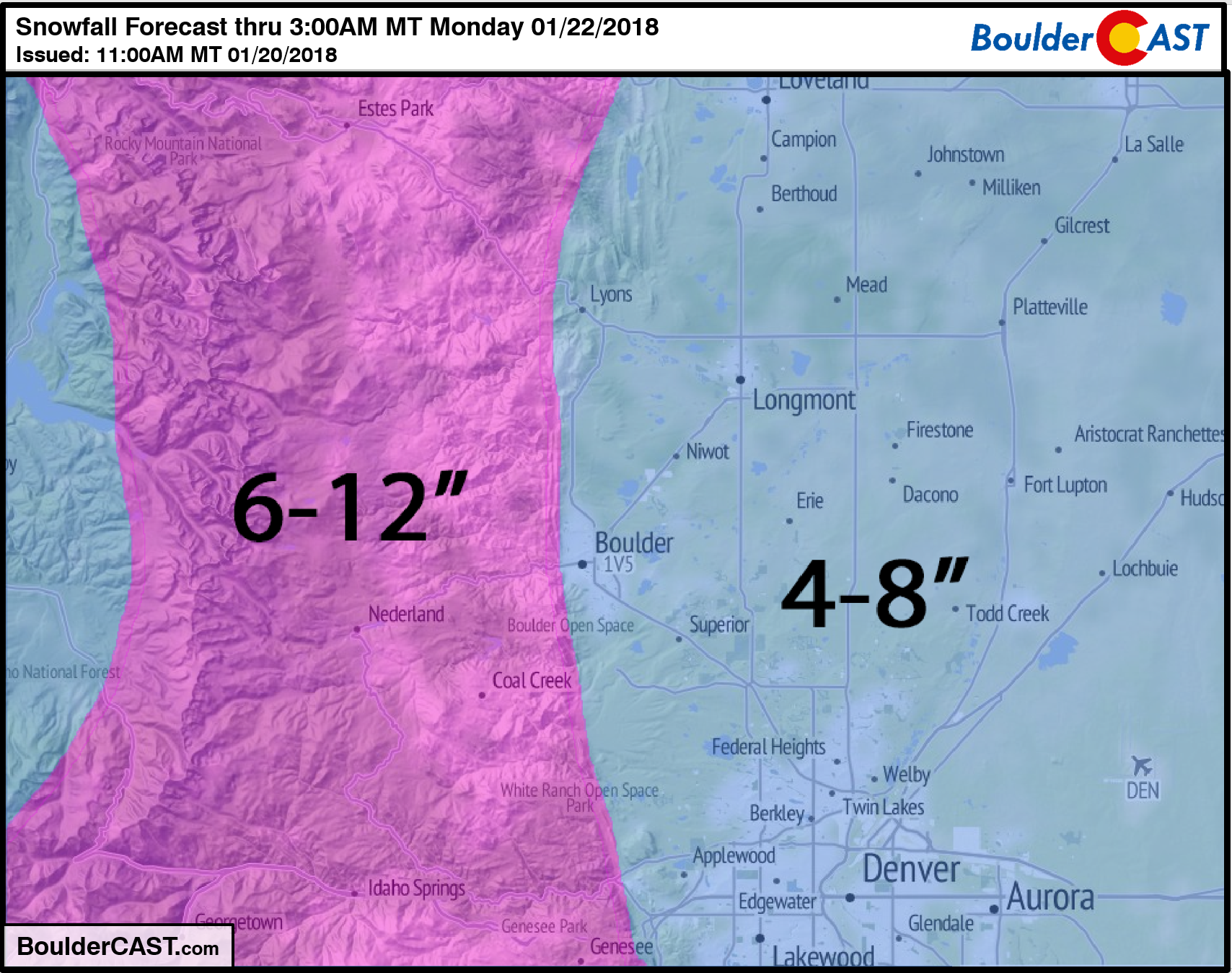
- Boulder / Denver Metro area – 4 to 8″ : The highest totals will be in the southern parts of the Metro Area where northerly winds mean upslope. Areas north of Boulder, such as Lyons and Longmont, will land on the lower end of this range.
- Foothills – 6 to 12″ : Upslope is not a MAJOR player from this storm, so the Foothills won’t do exceptionally better than the lowlanders. Still, fluffier snow ratios up there should allow for a few higher totals getting close to a foot.
- Mountains above 10,000 feet near and west of the Divide – 8 to 14″: This includes all of the ski resorts! Sunday will be a powder day for all! Check our PowderCAST page for specifics.
FORECAST CONCERNS:
Our forecast comes in slightly lower than what the National Weather Service is currently forecasting this morning (5 to 10″ Plains, 6-18″ in Foothills). It’s not much of a difference, but we are cautious as the latest round of models came in slightly lower than what they were showing last night for snow totals.
This storm has a good look, but the lack of deep winds with an easterly component typically doesn’t bode too well for us. This is especially troublesome for areas northwest of Denver, like Boulder and Broomfield. The surface low will be well to our south and east, with hints in the models that downslope could move into Boulder Sunday afternoon. Nonetheless, moderate to heavy snow Sunday morning should get everyone to at least the 4-inch mark across Boulder and Denver.
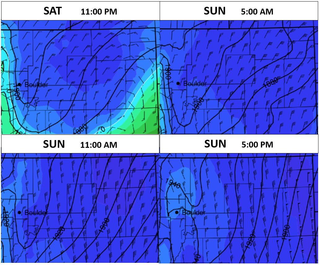
NAM 800 mb wind fields for the duration of the storm. After the initial surge of northeasterly upslope, winds back to northerly as early as Sunday mid-morning Sunday.
We also debated including the southeastern portions of the Metro area in our 6-12″ zone. These locations are closer to the powerful surface low and won’t have to worry about downsloping as much. If there is anywhere that has a chance to exceed 8″ on the Plains, it is probably the Centennial/Aurora area.
We’ll pass along any updates if needed during the storm at the top of this post. Our Premium members can look forward to a video forecast discussion later today.
Happy snow to all!
Please share our forecast:
.


You must be logged in to post a comment.