A pair of severe, supercell thunderstorms exploded across the northern Front Range late Thursday evening with very little advanced notice for residents. Hail larger than baseballs caused significant property damage on the northern and northeastern Metro area — roofing, siding, car windows and gardens stood no chance against the onslaught. The hail repair and insurance scammers are probably already knocking on doors this morning or making cold calls! We take a look at where the largest hail fell and why the forecast was so poor.

Go Premium, get all the perks.
Daily Forecast Updates
Get our daily forecast discussion every morning delivered to your inbox.
All Our Model Data
Access to all our Colorado-centric high-resolution weather model graphics. Seriously — every one!
Ski & Hiking Forecasts
6-day forecasts for all the Colorado ski resorts, plus more than 120 hiking trails, including every 14er.
Smoke Forecasts
Wildfire smoke concentration predictions up to 72 hours into the future.
Exclusive Content
Weekend outlooks every Thursday, bonus storm updates, historical data and much more!
No Advertisements
Enjoy ad-free viewing on the entire site.
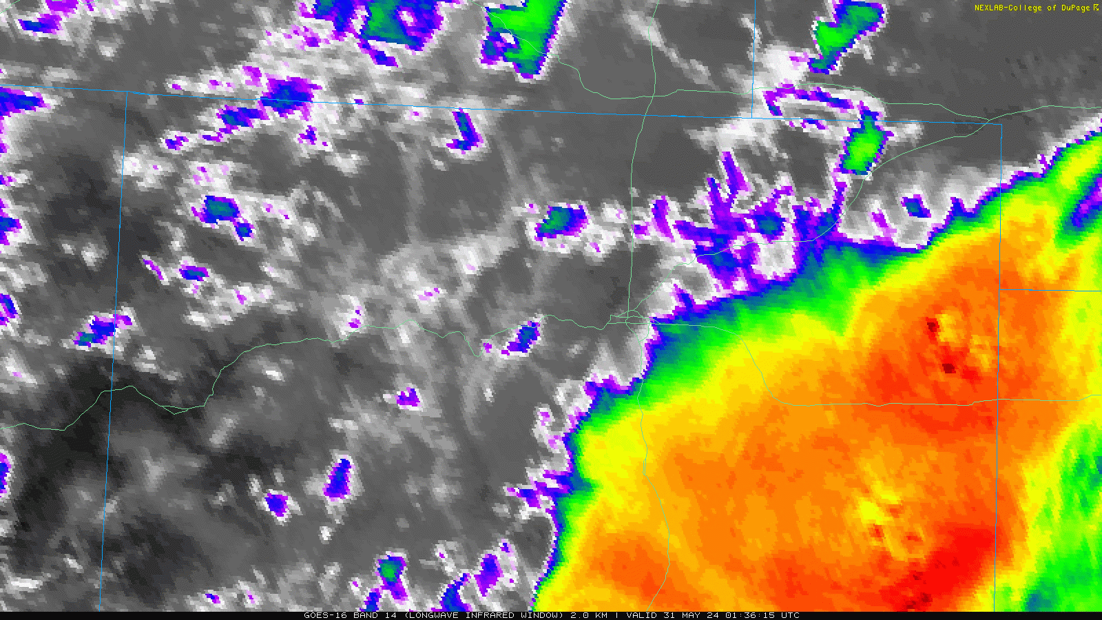
The GOES-East infrared satellite animation from Thursday evening shows that a rather innocent looking line of showers coming off the Foothills ultimately exploded into massive, rotating nocturnal supercells once they came out over the flatlands.
This great timelapse from Arvada shows Mother Nature’s fury in action as one towering supercell formed:
Absolutely insane metro Denver nocturnal supercell 30 May 2024 #9wx pic.twitter.com/VzNCP7KeUU
— Cory Reppenhagen (@CReppWx) May 31, 2024
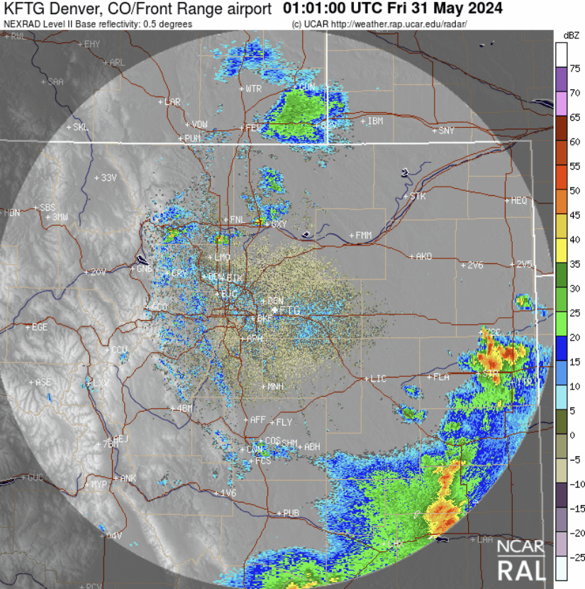
The radar animation from Thursday evening is shown below. Note that ignition of the first cell occurred just north of Boulder, clipping parts of Niwot and Gunbarrel with up to 1″ hailstones. This storm continued to blow up as it trekked east, cutting a nearly 50-mile long path of destruction all the way out past DIA. A second, smaller supercell developed just northeast of downtown Denver later in the evening, but didn’t last nearly as long.
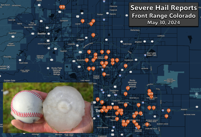
The map below shows the storm reports from across the region. Hailstones of 1-2″ were fairly widespread, with several spotty reports of very large hail over 2″ in diameter!
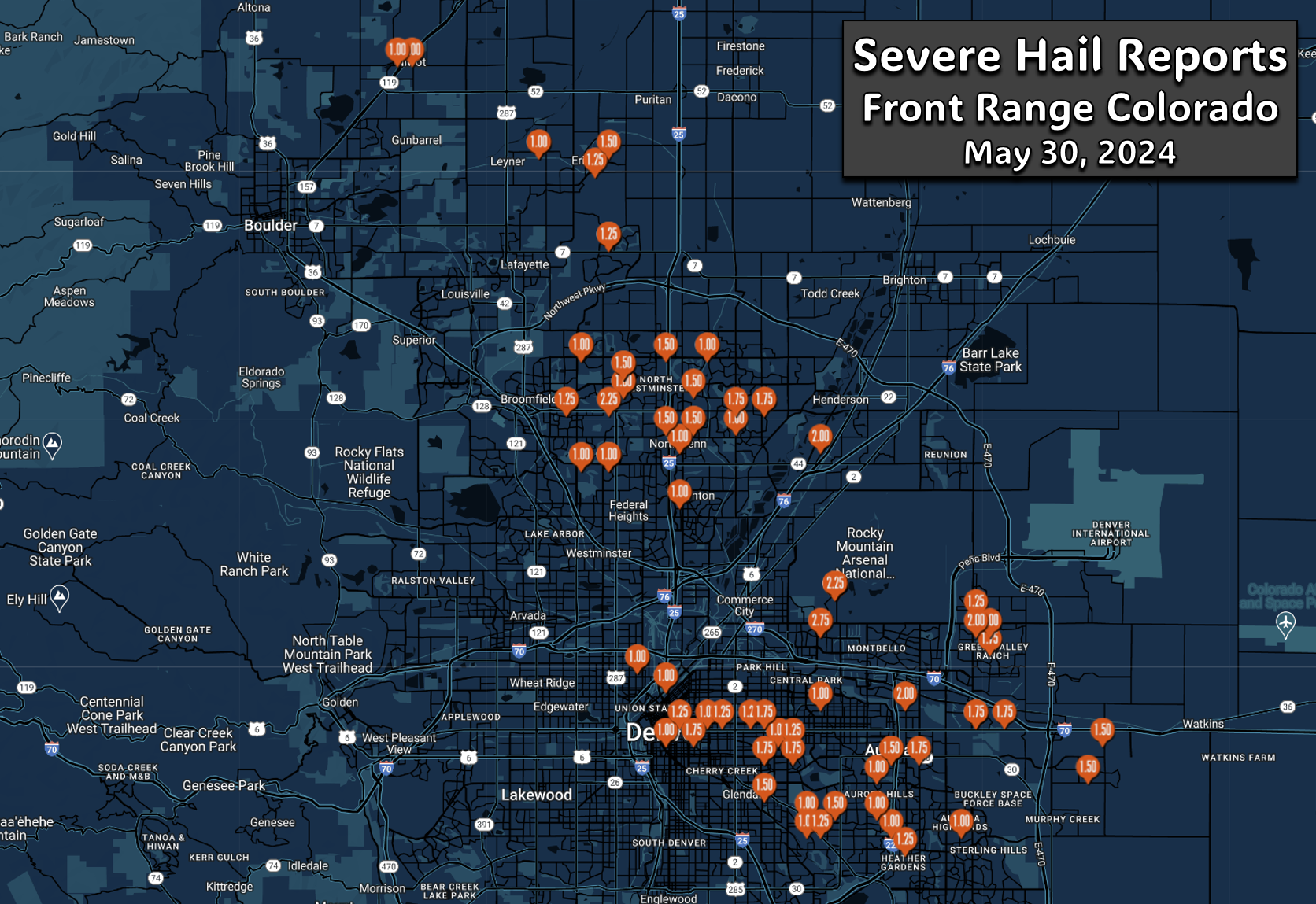
Here’s one of the huge hailstones from the NE side of Denver:
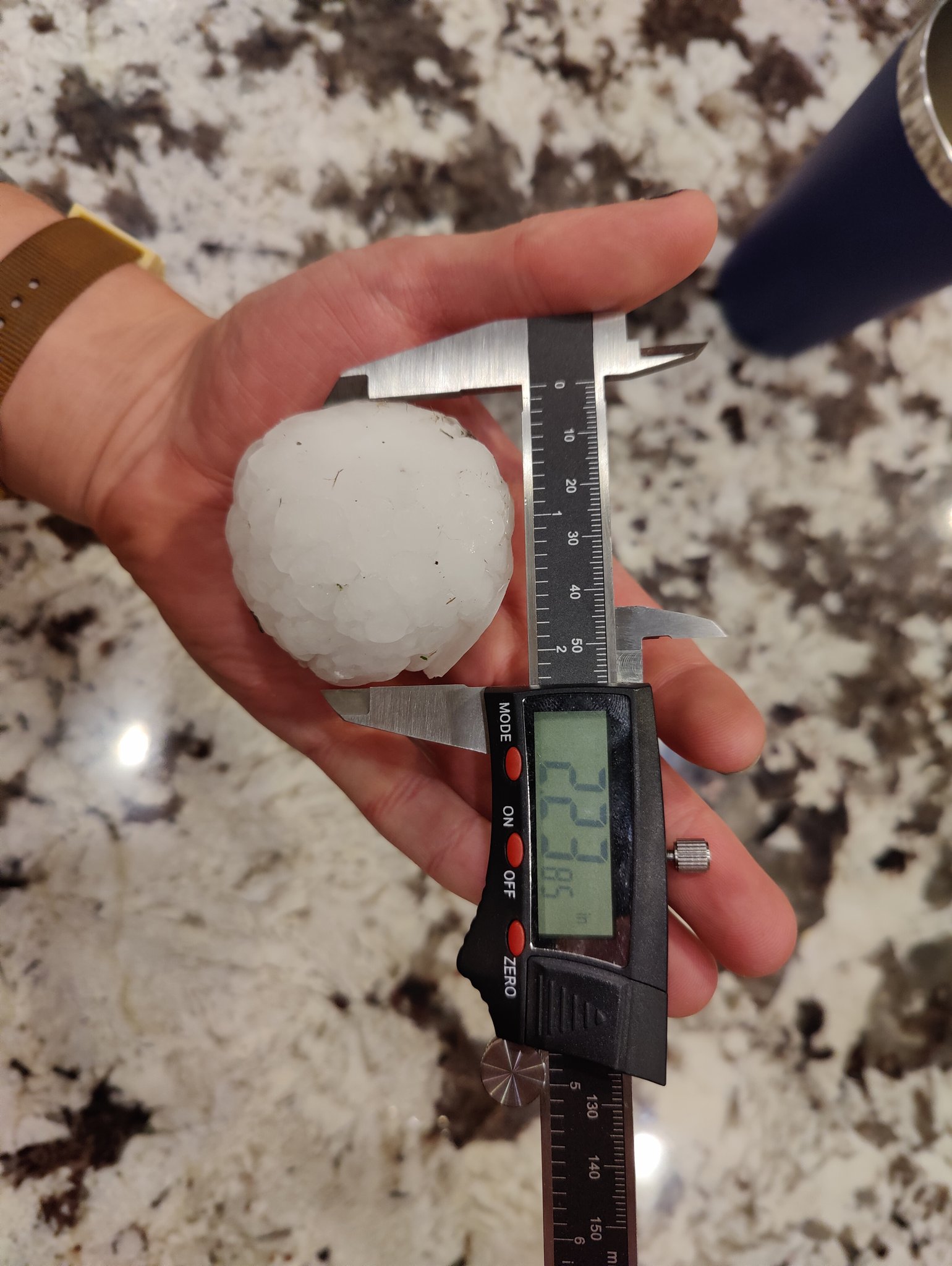
Photo by @blbman51 on X
We also captured a few similar sized hailstones from a grassy area in Broomfield. The hail was much less intense there though, with only a couple of these giant hailstones falling alongside what was basically just sprinkles.
Looks like we found the largest hailstone north of I-76. This 2.125" beauty fell near Broomfield (hail 2+" get triangle symbols on map). Winning? #COwx #Hail pic.twitter.com/KFhNEom4Fx
— BoulderCAST Weather 🏔️❄️ (@BoulderCAST) May 31, 2024
In some areas hail accumulated several inches deep, with sunrise Friday morning revealing what appeared to be snowy scenes out near the airport!
Wet to hail covered roads along Tower Rd near DIA btwn Pena and 56th Ave. pic.twitter.com/qoLGeCQTnN
— Jayson Luber (@Denver7Traffic) May 31, 2024
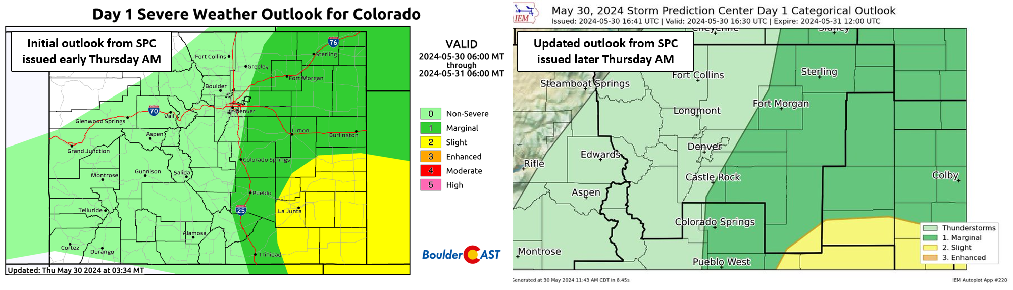
Unfortunately these supercells were poorly forecasted by both short-range weather models and meteorologists alike — so the public didn’t get much advanced warning — though the National Weather Service did a great job relaying warnings as the event unfolded. The NOAA Storm Prediction Center, often considered the gold standard in severe weather forecasting, completely excluded Denver from their severe weather outlook on Thursday. Their initial forecast from early Thursday morning was actually slightly more accurate then their updated forecast issued during the day — that latter shifted the severe risk box even further east of Denver. We can’t find the graphic right now, but something like 95% of all severe thunderstorms occur within the SPC’s outlook zone. The historic hailstorm that rocked Denver last night was a rare but costly misstep.
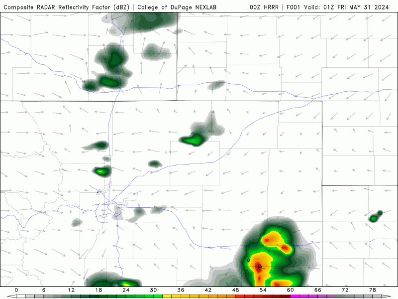
The simulated radar animation from the 6PM run from the HRRR model is shown below. This is one of the first few runs that started to show the development of severe nighttime thunderstorms capable of producing huge hail, but all of the indicated activity was shown to be well northeast of Denver.
Why was the forecast for severe weather so far off on Thursday evening? While the lower and middle atmosphere’s were both primed for strong thunderstorm development, in between the two was a thin but warm layer of air known as a capping inversion. This warm layer was expected to act as a “lid” on thunderstorm development for the immediate Denver area Thursday evening. The line of showers coming off the terrain had other ideas though — there was just enough oomph with it to remove the “lid” and the rest was history as unstable air was able to explode upwards unabated to over 50,000 feet above ground level, reaching the lower stratosphere at times. Forecasting severe weather in the immediate Denver area is always challenging on days where things are very marginal. Often there is always one or two lacking parameters which lead the models (and weather forecasters) astray. Sometimes it is moisture availability, other times a strong capping inversion, sometimes it is downslope flow. A similar busted forecast occurred just two nights ago around Greeley. While the hail wasn’t as large Tuesday night there, it was severe and did form much further west than any available forecasts.
The explosion of severe thunderstorms late Tuesday evening in Weld County was poorly forecasted by models & meteorologists alike. The storms formed along a westward moving outflow boundary, sitting atop #Greeley for hours. 2" diameter hail & 4" of rain was reported! #COwx pic.twitter.com/RfAgpNxmdt
— BoulderCAST Weather 🏔️❄️ (@BoulderCAST) May 29, 2024
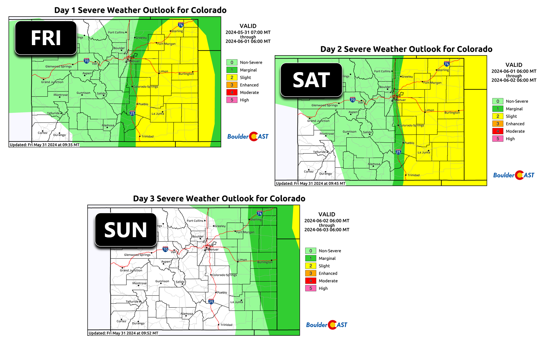
The threat of severe thunderstorms will continue through Sunday for eastern Colorado with essentially the same exact weather pattern staying the course over the region. Right now it looks like most of the severe weather will be east of Denver, but as we’ve seen two out of the last three nights, that prediction may not hold true. We’ll definitely be keeping an eye to the sky Friday and Saturday — and you should too!
Get BoulderCAST updates delivered to your inbox:
Go Premium, get all the perks.
Daily Forecast Updates
Get our daily forecast discussion every morning delivered to your inbox.
All Our Model Data
Access to all our Colorado-centric high-resolution weather model graphics. Seriously — every one!
Ski & Hiking Forecasts
6-day forecasts for all the Colorado ski resorts, plus more than 120 hiking trails, including every 14er.
Smoke Forecasts
Wildfire smoke concentration predictions up to 72 hours into the future.
Exclusive Content
Weekend outlooks every Thursday, bonus storm updates, historical data and much more!
No Advertisements
Enjoy ad-free viewing on the entire site.
Enjoy our content? Help us out and give it a share:


You must be logged in to post a comment.