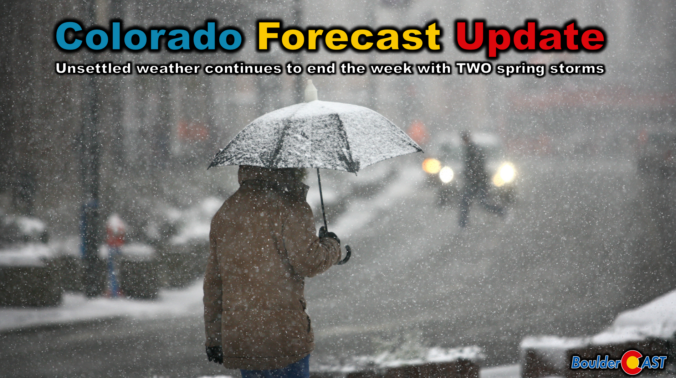
A big dip in the jet stream across the western United States will funnel two weak storm systems eastward in the coming days leading to a prolonged period of cool and gloomy weather to the Front Range that will take us right into the weekend. Our discussion here focuses mainly on the first storm set to move across Colorado on Thursday with a mixed bag of rain and snow. We’re expecting minimal travel impacts across the Boulder-Denver area due to warm temperatures, but some problems may occur in the higher terrain.

Go Premium, get all the perks.
Daily Forecast Updates
Get our daily forecast discussion every morning delivered to your inbox.
All Our Model Data
Access to all our Colorado-centric high-resolution weather model graphics. Seriously — every one!
Ski & Hiking Forecasts
6-day forecasts for all the Colorado ski resorts, plus more than 120 hiking trails, including every 14er.
Smoke Forecasts
Wildfire smoke concentration predictions up to 72 hours into the future.
Exclusive Content
Weekend outlooks every Thursday, bonus storm updates, historical data and much more!
No Advertisements
Enjoy ad-free viewing on the entire site.
A little rain, a little snow, to end the week
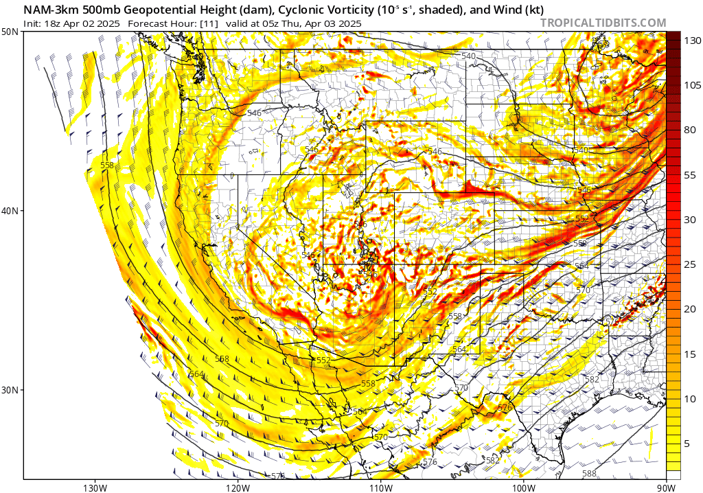
Back in our weekly outlook posted on Monday, we detailed how the back-half of this work week would be the period to watch for the most active and unsettled weather here in the Front Range. This remains the case, with not one, but TWO chilly disturbances set to impact Colorado in the coming days. These systems are embedded with a larger, longwave trough pattern situated across the entire western two-thirds of North America right now, outlined in pink below. This stalled pattern has kept our temperatures here on the cooler side the last few days, and has led to multiple outbreaks of severe weather along the eastern fringe of the trough — and it will contribute to historic flooding in the days ahead across parts of the Midwest and Deep South.

The first wave to reach the Front Range will be on Thursday, as a weak disturbance ejects across Colorado from the southwest, moving through the western part of the state during the day into Thursday evening. A second, slightly stronger low pressure will be slower to develop, taking shape across Arizona on Friday before trekking across New Mexico Friday night into Saturday. Both of these features will bring some precipitation to our area — but neither will be a direct hit. In this update, we’ll mainly focus on the first storm, as the latter one is still uncertain and has seen its impacts wane somewhat in recent model runs.
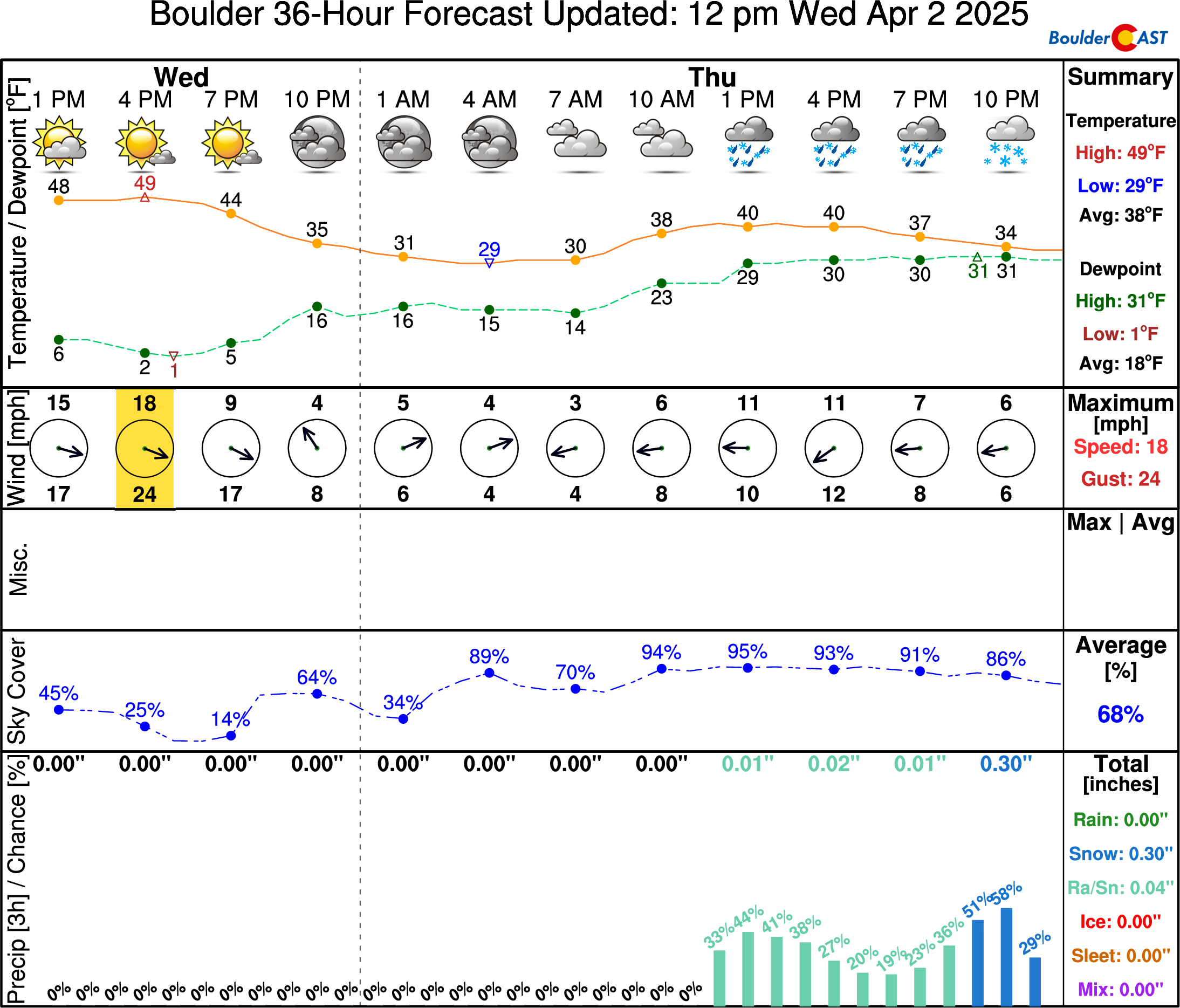
Pacific moisture and lift will both increase across Colorado Wednesday night with precipitation spreading into the Mountains. During the morning hours, a mid-level low pressure will start to spin up across Colorado, setting the stage for a period of upslope here in the Denver Metro area — as well as frontogenesis where winds come together south and west of Denver. The upslope is not particularly strong (15 MPH or less), but will reach up to at least 15,000 feet elevation offering the goodies for everywhere east of the Continental Divide.
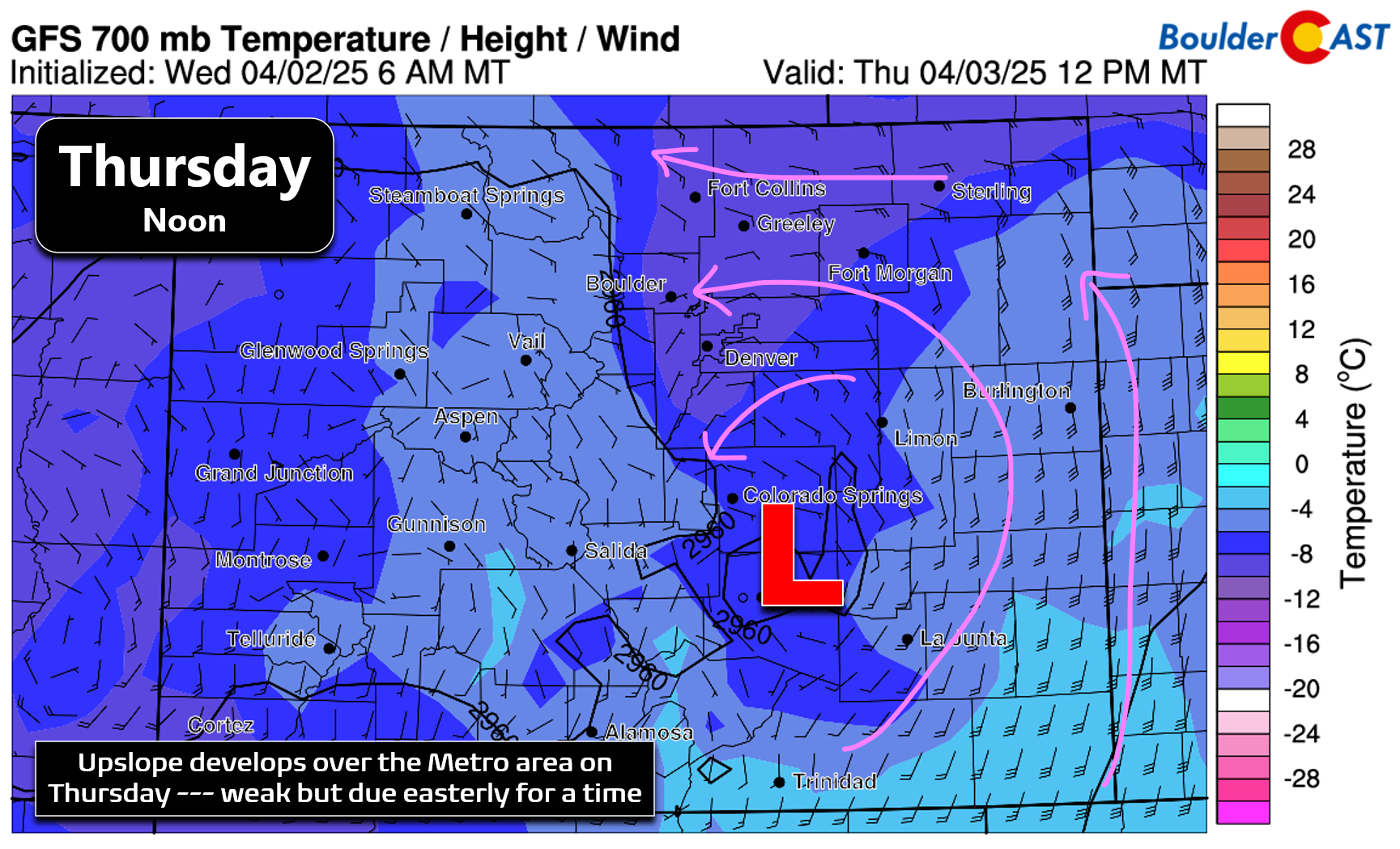
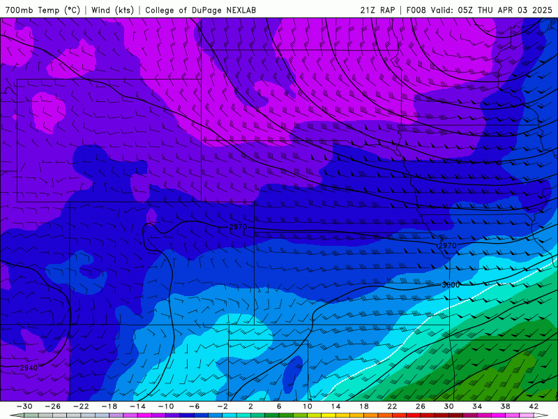
Upslope will be southeasterly Thursday morning, before turning almost due easterly Thursday afternoon, with a quick shift to downslope expected by midnight Thursday night. The evolution of mid-level winds from early Thursday morning into Friday morning is shown in the animation below. Pay attention to the wind barbs in the Boulder area!
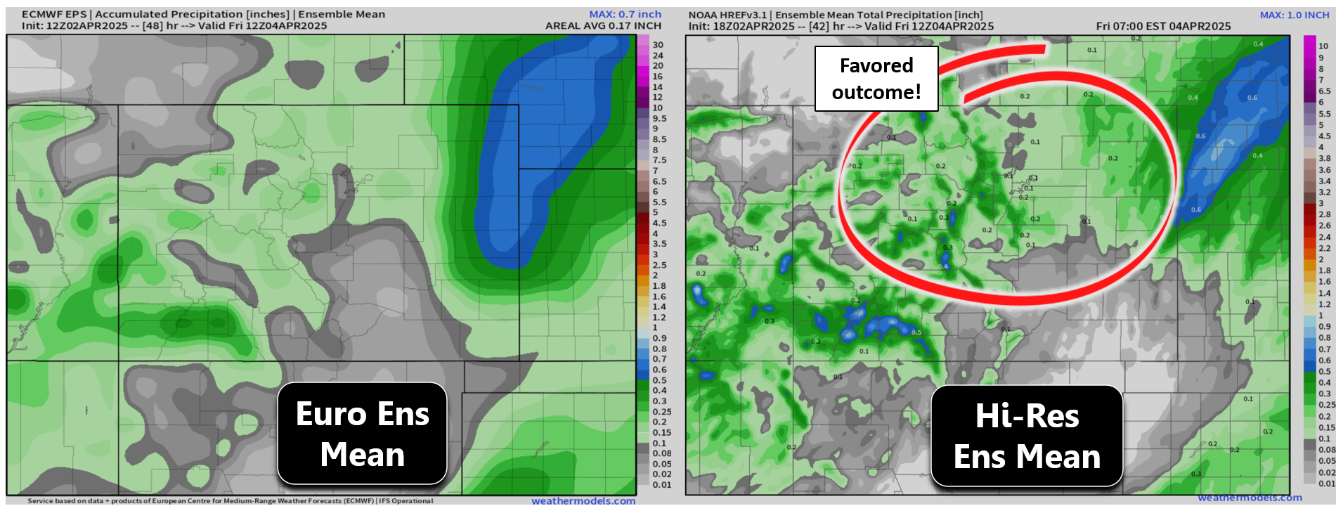
Overall, we’re not looking for a ton of moisture from this event — nothing what like transpired just a few days ago — there’s only about 12 to 18 hours of forcing for precipitation from Thursday morning into late Thursday evening. There’s still a lot of model spread on exact precipitation amounts, particularly across the Foothills, but for the most part this will be a light precipitation event with total of 0.1 to 0.2″ for the lower elevations (maybe less north of Boulder), with up to 0.5″ in the higher terrain.
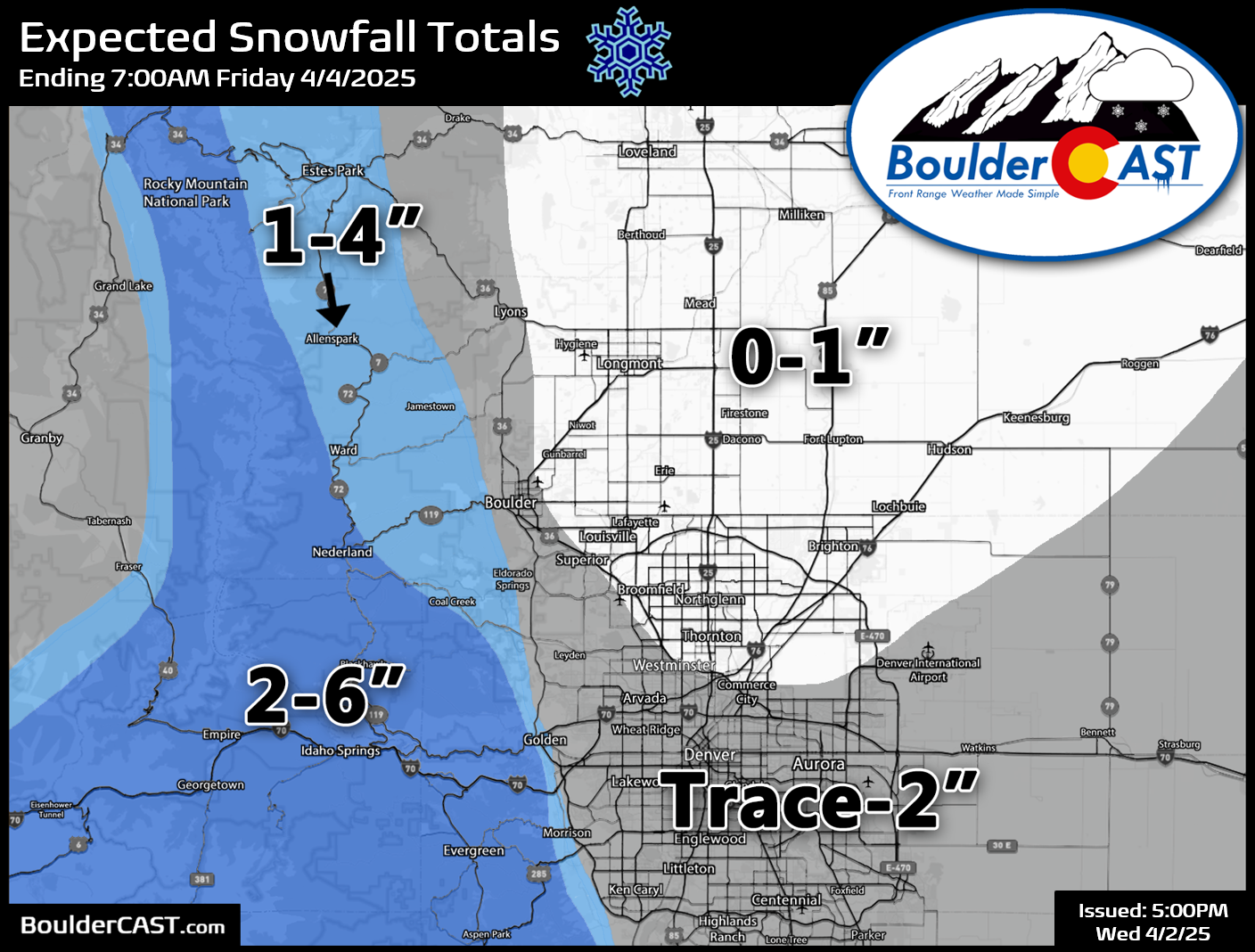
The other concern with this event will be temperatures. Yes it will be unseasonably cold, but cold enough for 100% frozen precipitation across all of the lower elevations. Right now we’re expecting all snow above 6000 feet (i.e. the Foothills and Palmer Divide), but it will be a mixed bag across the lower elevations with rain, rain/snow mix, and wet snow in varying doses Thursday, depending on time of day, elevation and precipitation intensity. Most areas below 5500 feet will see minimal accumulation (less than 1 inch on the grass), with up to 2 inches in locations between 5500 to 6000 feet (this includes far western Boulder). We’re forecasting 1 to 6 inches in the Foothills, with the highest totals above 7500 feet in Jefferson and Gilpin Counties. Given the April sun angle and above freezing air temperatures, travel should not be impacted in the Metro area from this event with any accumulation confined only to the grassy or elevated surfaces. Slushy travel impacts may occur Thursday into Thursday evening in the higher terrain, but nothing too bad.
General Timeline:
- A band of precipitation will spread into the Front Range from the southeast Thursday morning into midday as a rain/snow mix or all-snow initially.
- On-and-off rain/snow showers will linger through the day, shifting back towards mostly snow by evening. Snow accumulation may be most likely towards and after sunset Thursday evening when pockets of moderate snow and cooling temperatures overlap.
- Temperatures will stay in the 30s the entire day, warmest northeast of Boulder where close to 40° may be reached with mostly rain occurring there (sorry Longmont).
- Rain/snow will end in the late evening or around midnight Thursday night with temperatures falling into the 20s by sunrise Friday.
The aforementioned second storm system will bring another round of light rain and snow showers to the area during the day Friday into Friday night. Most of its energy will be south of our domain across New Mexico, but prolonged weak upslope may produce a similar amount of snowfall in the Foothills and nearby Plains to the first event. What once looked like a promising storm for us has really fallen apart in the models of late with a weaker, further south, and less organized low pressure now favored. We’re still going to see chilly temperatures Friday and Saturday, with unsettled weather lingering, but nothing significant. Time will tell on the final impacts from the next storm queuing up, but that’ll be a discussion for another day. Let’s get through Thursday’s springtime mixed bag event first…
Get BoulderCAST updates delivered to your inbox:
Go Premium, get all the perks.
Daily Forecast Updates
Get our daily forecast discussion every morning delivered to your inbox.
All Our Model Data
Access to all our Colorado-centric high-resolution weather model graphics. Seriously — every one!
Ski & Hiking Forecasts
6-day forecasts for all the Colorado ski resorts, plus more than 120 hiking trails, including every 14er.
Smoke Forecasts
Wildfire smoke concentration predictions up to 72 hours into the future.
Exclusive Content
Weekend outlooks every Thursday, bonus storm updates, historical data and much more!
No Advertisements
Enjoy ad-free viewing on the entire site.
Enjoy our content? Give it a share:


Hello — thank you for all that you do! I just have a picky language thing: I believe that it’s a “mixed bag”, not “mixbag”.
Ha, thanks, will have to look into this official lingo stipulation tomorrow 🙂
Thanks, fixed 🙂