We hate to be the bearer of bad news, but almost every single weather model has taken a significant nosedive in precipitation output for the remainder of the storm Tuesday into Wednesday. We discuss this latest data, what factors have contributed to the shift, and provide our final snowfall and precipitation forecast maps for what may end up being an underwhelming spring storm in the Front Range.

Go Premium, get all the perks.
Daily Forecast Updates
Get our daily forecast discussion every morning delivered to your inbox.
All Our Model Data
Access to all our Colorado-centric high-resolution weather model graphics. Seriously — every one!
Ski & Hiking Forecasts
6-day forecasts for all the Colorado ski resorts, plus more than 120 hiking trails, including every 14er.
Smoke Forecasts
Wildfire smoke concentration predictions up to 72 hours into the future.
Exclusive Content
Weekend outlooks every Thursday, bonus storm updates, historical data and much more!
No Advertisements
Enjoy ad-free viewing on the entire site.
T
he impressive and slow-moving storm system is currently drifting eastward near the New Mexico-Arizona Border to our southwest as of Tuesday morning. A surge of Gulf of Mexico moisture is flowing in now from the southeast and this will facilitate the development of widespread rain much of the day into tonight, aided by deep easterly upslope flow slamming into the terrain.
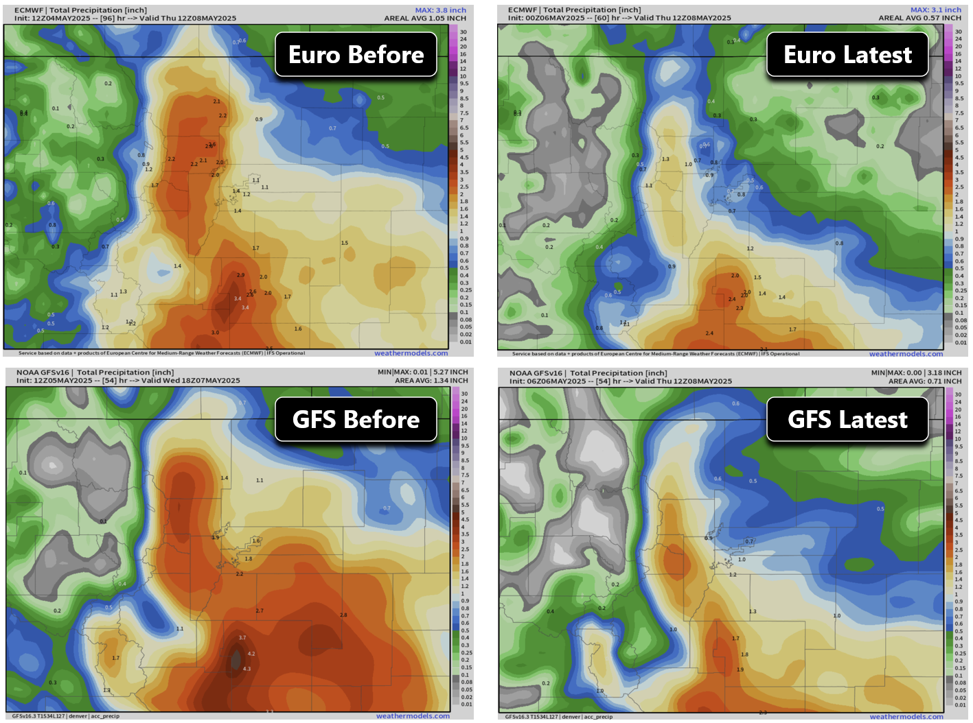
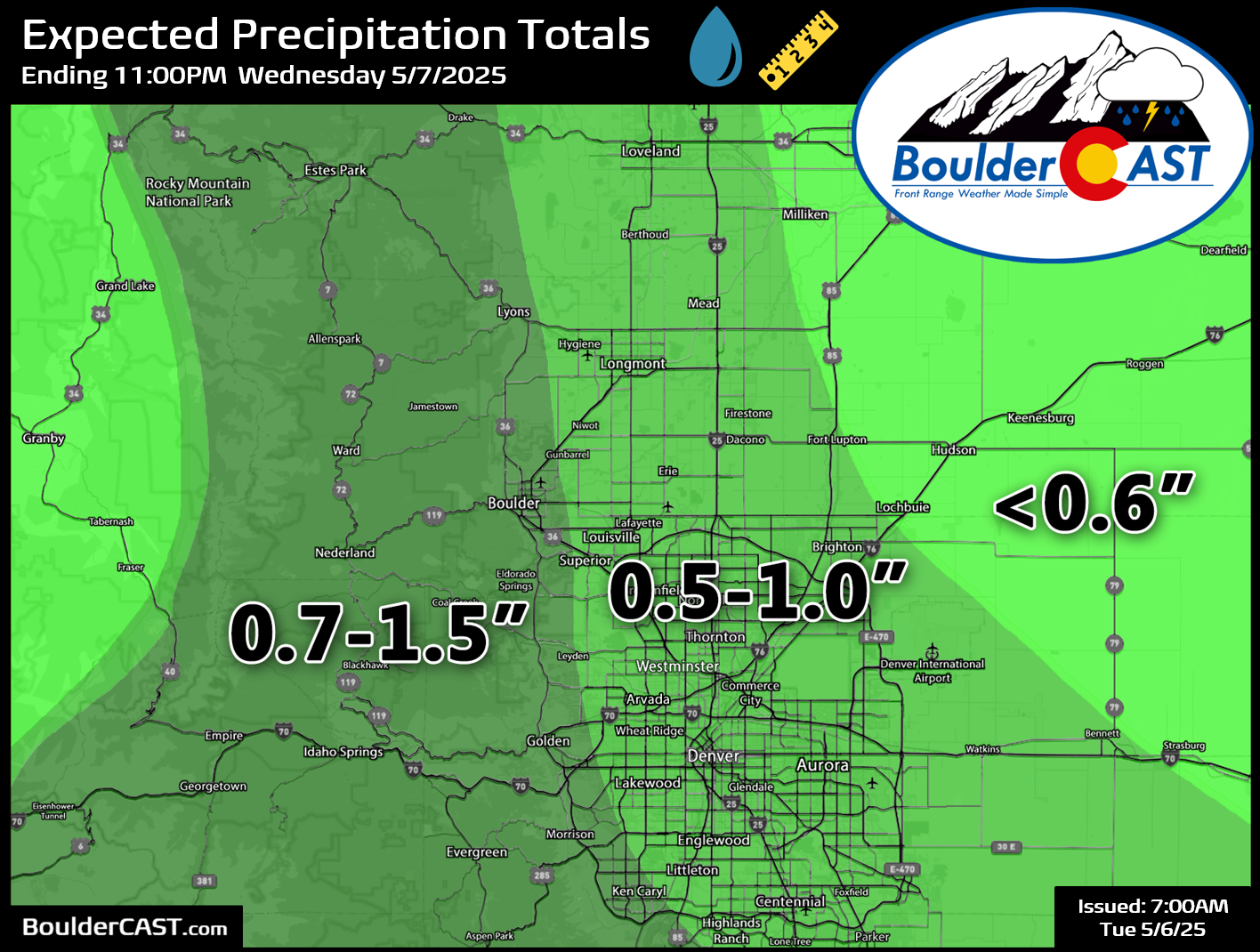
Unfortunately models have drastically backed off precipitation amounts for the Front Range. Just take a look at how the Euro and GFS models have completely nuked precipitation forecasts over just their last few cycles. Note the almost a 50% drop in our neck of the woods! It now looks quite likely that most of the Metro area will receive less than 1″ of precipitation from this event. The only place that still has a chance to exceed 1″ is in the Foothills and immediately adjacent Plains.
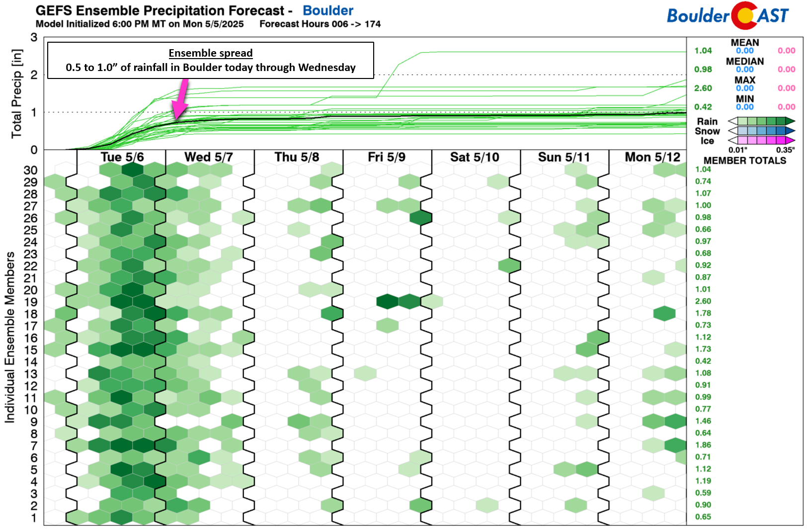
Ensembles have plummeted as well, with now even Boulder at serious risk to pick up less than 1″ of rain with this storm. The ensemble mean is around 0.85″.
Given the intensity and duration of the upslope flow coming into eastern Colorado today as the low pressure system passes across northern New Mexico (see below), it’s hard to believe how much precipitation has been cut back across all modeling suites. Yes there has been an overall decline in upslope intensity, now forecasted at ~25 MPH, compared to 35 MPH previously. However, even 25 MPH is impressive for any storm, especially with a due easterly component like we have today. The influx of moisture from the Gulf also appears to be slightly below projections from yesterday, likely the result of intense thunderstorm activity across Texas and Oklahoma. The reduction in moisture availability and upslope intensity are certainly frontrunners in our minds for causing this storm’s partial collapse.
We’ve seen a few comments already about the storm being a total flop because it wasn’t raining at sunrise this morning — you know you were thinking it too! The ongoing dry time right now was in the works all along, with an increase in rain activity expected through the morning. Rain is fairly widespread across eastern Colorado right now, especially southern Colorado where heavy rain (and higher terrain snow) is absolutely hammering away, as seen in the latest radar animation:

The HRRR model shows scattered to numerous showers moving in before midday, with widespread rain sticking around Tuesday afternoon into Tuesday evening.
We’ve adjusted our precipitation forecast map to reflect the most up-to-date potential for this storm. Most areas have seen amounts cut by 30 to 50%. We’ll gladly take any moisture we can get of course, but this sudden and ubiquitous downward trend is disappointing after the storm looked so promising for days leading up to the event.
The overall nosedive in precipitation will impact snowfall potential in the higher terrain as well. Not only will be there be less precipitation around to fall as snow, but snow levels won’t drop as much Tuesday evening and night with less intense and continuous precipitation rates. The cold core of the storm will arrive this evening, with 700mb temperatures forecast to bottom out around -3°C most of the evening and overnight. This will allow snow levels to drop down as low as ~7500 feet. Accumulation will be possible above that level, but not below. Areas above 8000 feet stand the best chance to see several inches of accumulation.
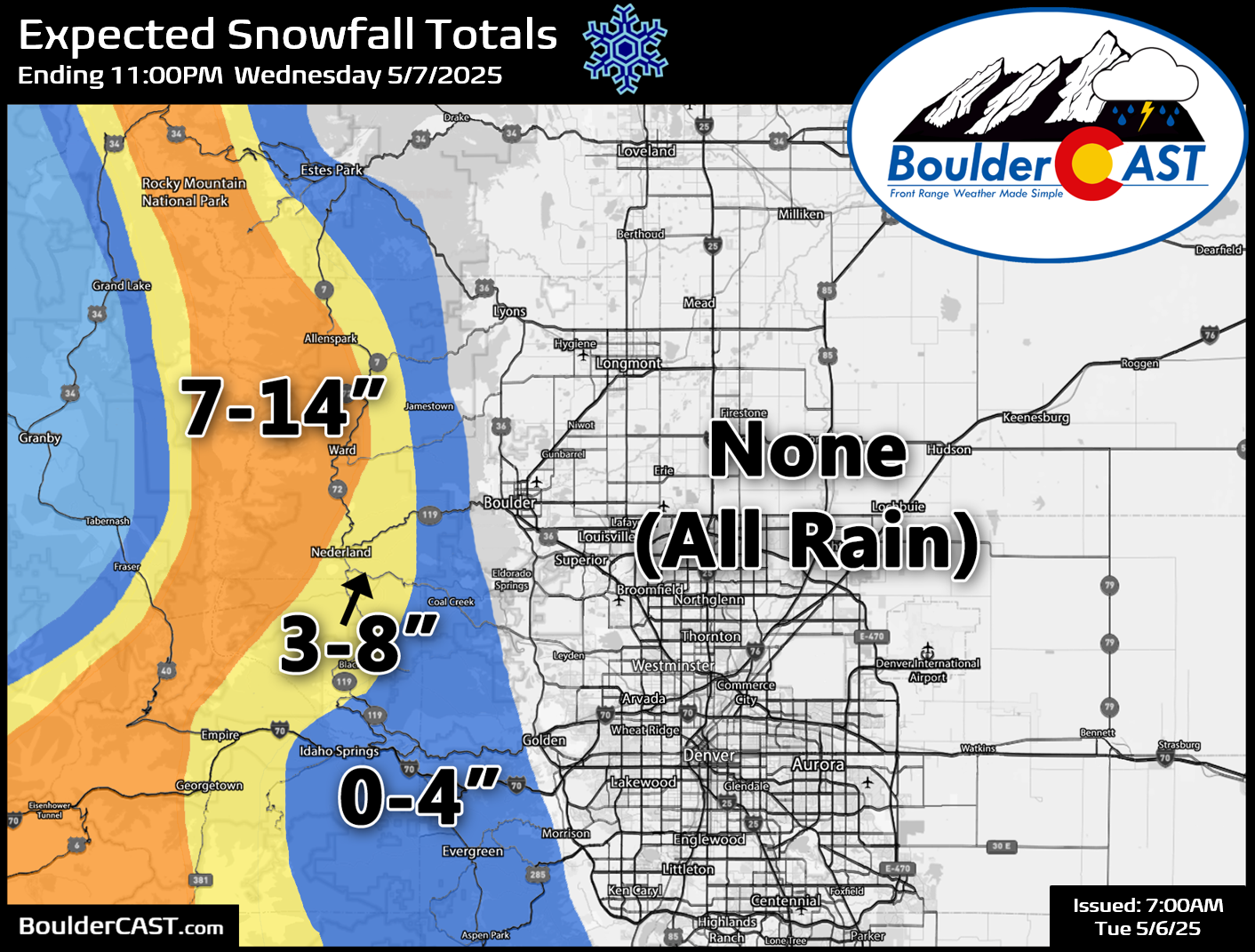
We’ve adjusted our final snowfall forecast map below accordingly based on the latest model data. Areas above 9000 feet along the Continental Divide still could see 7 to 14 inches of snow. However, areas where people actually live will see less as precipitation will begin as rain. Snowfall totals will be highly variable in the Foothills based on elevation, but in general this is what we are expecting:
- Above 9000 feet: 7 to 14 inches
- 8000 – 9000 feet: 2 to 8 inches
- 7000 – 8000 feet: 3 inches or less
- Below 7000 feet: Trace or nothing
Roadways in the higher Foothills and Mountains will become slushy and snow-packed Tuesday evening and night.
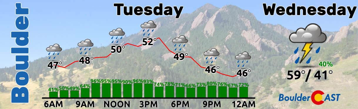
It’s certainly still going to be a very wet Tuesday, just as not as wet (in terms of raw rainfall output) as originally thought. With thick clouds and the rain around through the day, our temperatures will stay cool only topping out in the upper 40s to lower 50s at best. Rainfall will be most intense and widespread Tuesday afternoon and evening, before turning more scattered Tuesday night through Wednesday. Precipitation won’t fully wrap-up from this storm until Wednesday evening as upslope flow wanes and the storm’s energy shifts too far off to the east.
This isn’t exactly the news we wanted to share this morning with raindrops knocking on our door, but there you have it. Enjoy the cool and rainy days ahead!
Enjoy our content? Give it a share:


Thanks for the update, as always.
Cheers!