
Another potent cut-off low is eying the region once again, bringing much-needed rain and snow Sunday into Tuesday.
This week has seen a pattern more appropriate for July than April, influenced by the presence of a shortwave 500 mb ridge, and decent mid-level moisture, both combining with daytime heating to form weak, high-base thunderstorms each afternoon. Boulder has received a trace of precipitation each day, with a few rumbles of thunder and high temperatures ranging from 65 to 70 degrees, with the Foothills in the 50’s.
This trend will continue through Saturday, ahead of the next storm system which will impact our region on Sunday/Monday. A broad, upper-level trough will dig into the Southwest, forming a cut-off low over New Mexico early Sunday (see below). This storm system is eerily similar to the last one, but it appears to be taking a more southern track and it won’t have as much cold air to work with. Models have been in surprisingly good agreement, which is a welcomed change from last weekend!
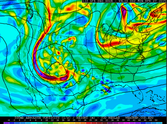
500mb vorticity and height from the GFS model valid at 6pm MT Sunday. The closed low over New Mexico is visible, with moist SE flow streaming into our region.
Saturday will end up looking similar to the past few days. Clouds will build through the day as the trough, and an embedded shortwave feature moving across the state, make their approach. Saturday will give us a good chance of showers and thunderstorms in the afternoon through the evening, developing first over the mountainous regions. These storms will be more widespread than they have been recently. Snow levels will be around 10,000 feet at this point, giving most areas strictly liquid precipitation.
By Sunday morning, the closed low will begin materializing, bringing upslope flow and a weak cold front through NE Colorado before sunrise. This will drive snow levels down a bit, but it should remain warm enough to keep it all rain below ~7,000 feet, even Sunday night. The battle between weak cold air advection, clouds, precipitation, and solar heating will see the Plains struggle to get out of the 40’s on Sunday (and Monday!), with temperatures falling into the upper 30’s Sunday night. The best upslope will occur between noon Sunday and noon Monday, so the heaviest precipitation will be during this timeframe. Despite the less-than-ideal south-easterly wind direction, the precipitable water vapor will be above 0.6 inches from early Sunday into Monday, so the importance of direction is diminished. Enough low level moisture, upslope, and cold air aloft will linger to keep the chance of light showers around through Tuesday morning. The models are in general agreement that most of the county will get at least 0.5″ of precipitation, with areas from Boulder west getting 1.0-2.0″. The Short Range Ensemble Forecast for Boulder shown below has mean precipitation over 1″ for the storm.
Just a small warning: at this time, both the NAM and Euro models have the closed low forming just a bit further south, which would curb our precip from this event slightly. However, we tend to believe the other guidance more, as the GFS, Canadian, WRF, and ensembles share the more northern storm track. But as we learned last week, computer models have a rough time with cut-off lows, so stay tuned!

SREF 12z cumulative precipitation forecast for Boulder through Monday, with a spread of 0.75 to 1.50″.
Despite potentially dropping more than an inch of liquid, our region will only be experiencing a glancing blow from this storm system. The real winner will be SE Colorado! The precip totals output by the WRF down there are in the 1.5 to 3.5″ range in the high country, with comparable amounts extending eastward onto the Plains (see below). This is great news, as that region has been much drier than ours, thus far this winter.
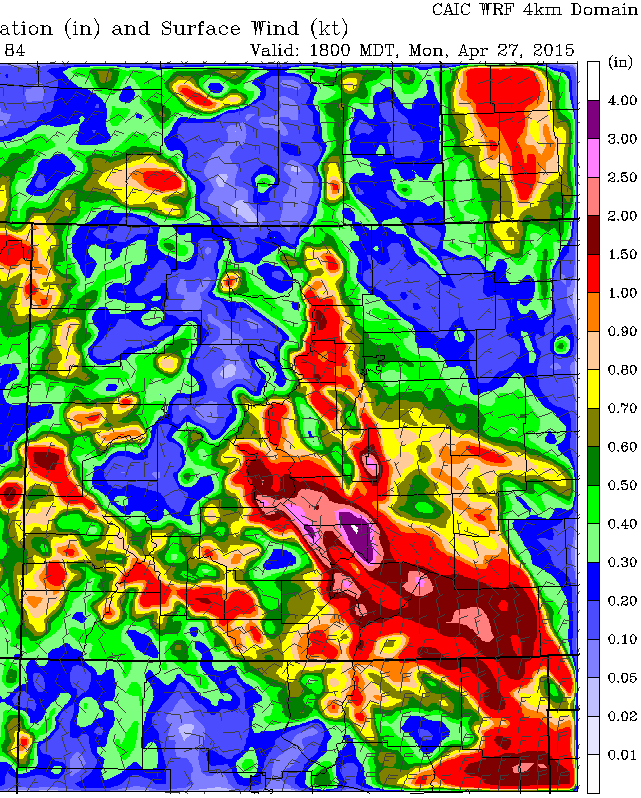
WRF Cumulative precip forecast for Colorado through 6pm Monday. Notice the values for Boulder County, but also the bullseye over SE Colorado.
By Tuesday evening, skies should clear and Wednesday will be sunny again with seasonal temperatures as the storm system moves away from Colorado and high pressure builds.
THE FORECAST:
The Plains: Clouds will increase Saturday afternoon, with a chance of showers and storms into Saturday evening. Highs will be near 65 degrees. After a break in the action overnight, steady precipitation will develop Sunday afternoon and persist through early Monday. Highs on Sunday will be around 50 degrees. Rain will decrease Monday afternoon, but clouds and a chance of light showers will linger through Tuesday morning. Monday will still see temperatures 10 to 15 degrees below normal, with some slight moderation into Tuesday. By the end of next week, a broad upper level ridge will be in place over the West, with drier conditions and temperatures climbing well above normal!
The Foothills: Brief downslope winds will develop overnight Friday into Saturday morning , with gusts up to 45mph in some areas. Saturday will have clouds, rain, and storms developing through the afternoon with highs in the 50’s. Sunday morning, precipitation will pick up again as deep upslope develops. Snow levels will be dropping through the day into Monday morning, beginning around 9,500 feet and dropping to around 7,000 feet. The lack of cold air and the April sun will limit accumulations, but expect in the 2-6″ range through Monday above 7,500 feet, with little to no accumulation below 7,000 feet. The precise snow levels may need some adjustment as the storm approaches. Temperatures will moderate into the 50’s and 60’s by week’s end.
The Mountains: Sunshine Saturday morning will give way to scattered rain and snow showers in the afternoon and evening. Snow accumulations should be light in most areas, with less than an inch. Sunday, things go downhill, with snow developing and persisting into Monday morning. Light snow showers will linger through Monday. When it is all said and done, areas above 9,000 feet can expect 6-12″ of white stuff!


You must be logged in to post a comment.