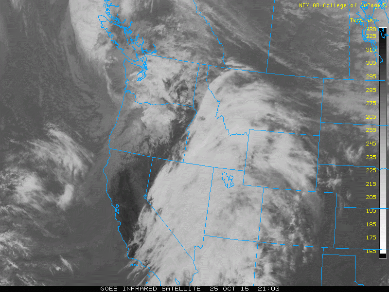
After a very tranquil and mild weekend with temperatures in the upper 60’s, this week’s weather will be cooler and more seasonal. We start off the week under cloudy skies due to an upper level system in the Pacific Northwest. The pattern then turns more active late in the week, with even the potential for a few snowflakes. Continue reading for all the details!
Category: Winter Weather (Page 137 of 139)
These posts contain some discussion of the white stuff, whether it be mountain snow pack or a Front Range snowstorm.
Through October 18th, Boulder is sitting nearly 10 degrees above normal for the month of October. This week will aim to change that trend, with a drastic cool down and the return of precipitation to the region.
September was exceedingly dry and warm across much of eastern Colorado. Consequentially, the wildfire threat is increasing with each passing day. More than half of Boulder County is now under a complete fire ban. Will October offer up the soaking rain and mountain snow that we desperately need? Read on as we examine Boulder’s climatology and consider the current state of the atmosphere to give our outlook for the next month.
With El Niño now approaching record levels, we crunch the numbers to see what type of impact we could potentially see in Boulder as the we head through the autumn season. Spoiler: we think it involves an epic snow storm!
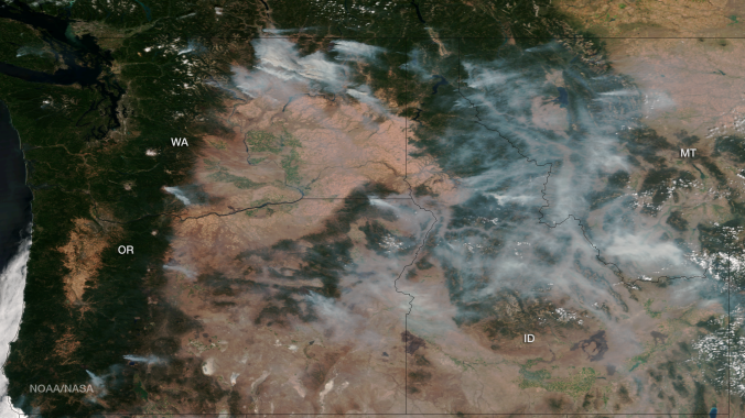
After a gorgeous Sunday across the entire Boulder area, the heat returns as the ridge of high pressure rebuilds from the south. By midweek, a system approaches, bringing a chance of storms back into our forecast. The past week has also been quite hazy/smoky, most prominently on Saturday. When will the smoke clear? Read on to find out!
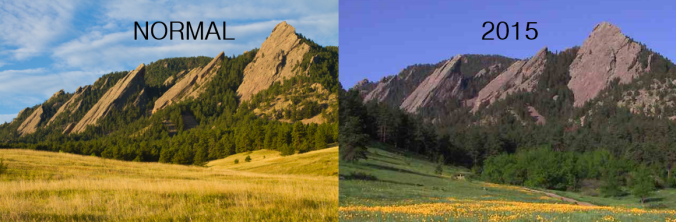
Prolific snow and rain through the spring and early summer has painted an exceedingly green picture across eastern Colorado this year. Grasslands and meadows that are typically an ugly shade of brown by now are tinted in a vibrant emerald hue. As a result, there has barely been a single wildfire across the state this summer. We take a look to see just how extraordinary the amount and consistency of the precipitation in Boulder has been in 2015.
The third episode of the BoulderCAST Podcast, titled Ark Building 101, is now available! Will the Bolder Boulder 10k race be a complete wash out? Why was Joseph recently carried to Winter Park’s base in a sled by the ski patrol? Listen to find out!
The second episode of the BoulderCAST Podcast, titled Rain Rain Go Away, is now available! Why do tornadoes typically struggle to form in/near the mountains? Was the 2013 Boulder Flood related to a tropical cyclone? Listen to find out!

Live View of Boulder

Current Conditions

Live Radar

Recent Premium Posts

BoulderCAST Daily – Fri 06/12/26 | Poor air quality and warm temperatures
😷 Air Quality Alert — Poor air quality today with warm and stagnant …
This Weekend in Colorado Weather: From 90s to 60s?! A Complicated Weekend Forecast Lies Ahead
🌞 Bluebird Thursday: Post‑frontal airmass delivers mostly clear skies, low humidity, and highs …
BoulderCAST Daily – Wed 06/10/26 | Strong Winds Drive a High‑Risk Day of Fire Danger Across Colorado
🌥️ Tuesday’s cloudy bust — Tuesday’s thick mid‑level clouds kept temps 5–15°F cooler …
3-Day Forecast

Trending Content

© 2026 Front Range Weather, LLC
You must be logged in to post a comment.