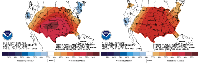
With our last measurable precipitation occurring nearly four weeks ago, enough is enough. After enduring a few days of near-record heat to start the week, our focus will shift to a potent storm system approaching Colorado on Thursday. Though uncertainty remains elevated, the Plains do have a chance of seeing their first accumulating snowfall of the 2016-17 season. Read on for all the details.
Category: Winter Weather (Page 126 of 139)
These posts contain some discussion of the white stuff, whether it be mountain snow pack or a Front Range snowstorm.
We got a couple emails from folks wondering if what they heard on the news was true…will there really be a snowstorm next week? We provide you with the latest information and give our take on the situation.
There is little weather to speak of for this first full-week of November with a ridge of high pressure over Colorado maintaining itself. There will be lots of sunshine and temperatures once again above normal…something which has been the story for much of our fall. One thing of note is a potential cold front late in the week, although it will likely not prevent us from remaining warmer than normal for this time of year. Read on for our full outlook of the week ahead.
Following a very dry and historically warm month of October, the fire bans are back as the drought continues to expand in coverage across the Front Range. For the lower elevations, the most prominent fall color this year has been brown. Will November bring a wetter weather pattern that we desperately need? Read on as we examine Boulder’s climatology and consider the current state of the atmosphere to give our outlook for the next month.
We’ve had quite an unbelievable stretch of weather the past several weeks. However, the bad news is that there hasn’t been any rain in a long time. In fact, Boulder County is once again under a fire ban. We really could use rain or snow, but this week will unfortunately not bring any respite from the dry spell. This first half of the week will focus on a weak shortwave and mountain snow, with the latter week featuring warmer weather and a potential cold front. Read on for our full forecast.
Do you know what today is? If you’re thinking October 20th, while correct, you’re missing the more important point. Today is the climatological median date of Boulder’s first measurable snowfall! This means that exactly half of the time, the season’s first snow occurs before this date, while half of the time it occurs after. While we understand you’re disappointed to know that 2016 is officially in the bottom half of our climatology percentiles, fear not. The odds of our first snow remaining at-large is decreasing every day! We discuss where the snow has been this year, and what lies ahead as we close out the month of October.
Our recent warm stretch is more typical of mid-September than mid-October, but it’s really hard to complain. Under the influence of an expansive ridge of high pressure, temperatures have exceeded 80 degrees each of the last four days, with several close-calls for record highs in many Front Range cities. For the week ahead, we’ll see a brief cool down and spurts of Mountain snow, but revert to boring summer-like weather before the weekend. Continue reading for our complete outlook of the upcoming week.
The Denver area had a great weekend with temperatures above normal. The week ahead starts out warm, but takes a quick dip midweek to more seasonally appropriate weather. In the High Country, rain and snow will be possible at times, but over the Plains, mostly dry conditions will dominate. Read on for our full weekly forecast.

Live View of Boulder

Current Conditions

Live Radar

Recent Premium Posts

BoulderCAST Daily – Sat 06/06/26 | Isolated afternoon storms as the heat continues
🥵 Middle 90s dominate today and Sunday 🌩️ Front Range storms each afternoon/evening …
BoulderCAST Daily – Fri 06/05/26 | A streak of 90s set in through the weekend
🥵 A streak of 90s today through the weekend with low to middle …
This Weekend in Colorado Weather: Early-Season Heat Ramps Up — First 90s of the Year on the Horizon
🌬️ West–northwest flow Thursday supports high‑based convection with gusts to 35 MPH; virga …
3-Day Forecast

Trending Content

© 2026 Front Range Weather, LLC