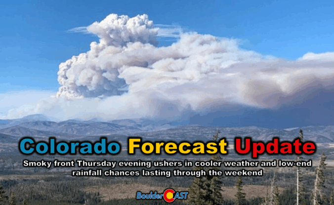
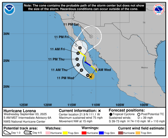
Thursday’s shaping up to be a busy weather day across the Front Range. We’re looking at hot temperatures, gusty winds, and a cold front arriving by evening that’ll bring a noticeable drop in temps — along with a wave of wildfire smoke. We’ll walk through what to expect today, how the weekend is shaping up, and whether any moisture from Hurricane Lorena might sneak into the region.
Category: Tropical Weather (Page 2 of 19)
September kicks off with a mellow vibe across the Front Range — warm days and mostly dry skies are expected. But don’t let the quiet start fool you. Between drifting wildfire smoke, sneaky cold fronts, and a potential tropical system by the weekend, there’s more nuance in our forecast this week than meets the eye. Read on as we break down what to expect day by day, plus what might shake things up by the weekend.
The unsettled weather pattern isn’t done with us just yet—and that’s good news for the rain-starved Front Range. While recent days have underdelivered in most areas, this week still holds promise for more moisture and continued cool weather. We break down when and where the best rain chances will line up this week, why optimism is cautious, and what to watch for as the pattern turns warmer and drier heading into Labor Day Weekend.
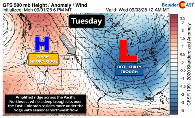
If you’ve been quietly rooting for a late-season monsoon comeback, it might be time to recalibrate. Boulder’s summer has been historically dry, and this week won’t offer much relief, at least initially. A persistent ridge of high pressure is set to lock in more heat and keep moisture at bay. But don’t tune out just yet—there’s a subtle pattern shift coming that could open the door to cooler temps and better storm chances by the weekend. Let’s take a closer look.

Hint: All of the clues are related to Boulder, Denver, and/or Colorado weather. OK, well most of the clues…


Live View of Boulder

Current Conditions

Live Radar

Recent Premium Posts

BoulderCAST Daily – Thu 01/08/26 | Snow develops today but still some uncertainty, amounts have been lowered
❄️ Snow develops today: Snow develops today, but uncertainty still lingers with two …
BoulderCAST Daily – Wed 01/07/26 | Quiet today but snowflakes are on the horizon tomorrow
⛅ Quiet Weather Today: Highs will be mild in the upper 50s in …
BoulderCAST Daily – Tue 01/06/26 | Critical Fire Conditions Today
🔥Critical Fire Conditions: Fire Weather conditions could be critical today with gusty winds …
3-Day Forecast

Trending Content

© 2026 Front Range Weather, LLC