Category: Premium Content (Page 112 of 451)

This content is for Premium Members only.
Premium BoulderCAST Daily – Tue 02/13/24 | Staying pleasant the next few days before a cold front arrives Thursday evening

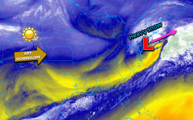
West-southwesterly downslope flow will continue today across Colorado with basically no changes expected in our weather, other than being a few degrees warmer than our Monday. GOES-East satellite imagery shows the setup across the nation. The storm which brought us snow Friday into Saturday is now producing heavy snow in New York City and Boston. Here in the Front Range, …

Premium BoulderCAST Daily – Sun 02/11/24 | A sunny Super Bowl Sunday “kicks off” the melting

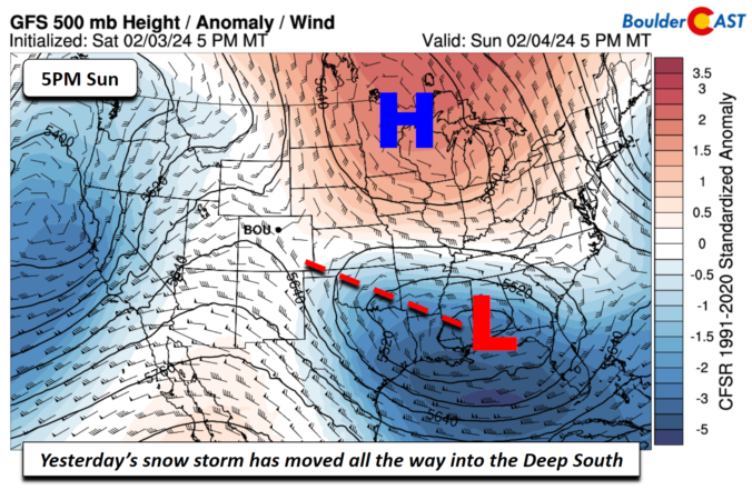
As of Sunday morning, the mid-level low pressure which was responsible for yesterday's light snowfall here (but not Friday night's heavy snowfall) continues to head eastward. It is currently located in east-central New Mexico, about to cross over into Texas. The final track of the storm was a touch further south than advertised, but the snow event played out more …

Premium Mid-Storm Update – Sat 02/10/24 8:00 AM | Up to 10″ of snow fell overnight, and we’ve still got ~18 hours of light snow to go!

Snow, heavy at times, was falling through most of the overnight period across the Denver Metro area. A nearly stationary band of convective snow showers formed along a line of convergence in the northern Metro area, stretching roughly from Lakewood, through Broomfield and northeast to Greeley. The radar from Friday night around 9:30 PM is shown below. A few rumbles …

Premium BoulderCAST Daily – Thu 02/08/24 | Gusty and cooler

Acold front has moved through the region. However, the bulk of the cold air is off to our northeast in Nebraska and the Dakotas. We do have chillier air filtering in with the northwest winds so highs will be in the upper 40s to around 50. Gusty northwest winds will range from 20-30 mph this afternoon, with up to 50 …

Premium BoulderCAST Daily – Wed 02/07/24 | Staying mild but with a low-end chance of late-day showers

Below shows yesterday's high temperatures across the Front Range. Note the bifurcation in highs from the low 50s in Denver/Boulder and the upper 50s to low 60s in south Denver towards Centennial. The southern branch of the snow field is obviously not as deep as it is further north. Highs today will be similar but a few degrees warmer in …

Premium BoulderCAST Daily – Tue 02/06/24 | We continue to melt the snow but it grows in the higher terrain

Below shows a visible satellite animation from yesterday afternoon into the early evening. Along with the increasing high clouds building in from the west, notice how the snow cover over Denver and Boulder slowly melts a little from the edges and also in the center. It's pretty cool to visualize and to see the solar heating in action via heating …

Premium BoulderCAST Daily – Sun 02/04/24 | Drying out after yesterday’s snow

Yesterday's snow event brought some surprises and also something we expected. Most of the Front Range saw between 4 and 6 inches, especially along and east of I-25. Denver Airport, for example received some 5.5 inches. A swath of 6-10 inches fell just west of I-25 between Louisville/Lafayette and Arvada. Boulder looks like it ended up with about 6-8 inches. …

« Older posts Newer posts »