


NOTICE: Due to the federal holiday, our usual Monday weekly outlook will be posted instead on Tuesday. Please check back then for the latest on Front Range weather!
Category: Forecast (Page 52 of 169)
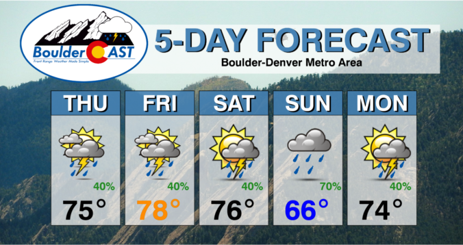
We’ve got a stormy start to the week with continued cool temperatures and a risk of hail and flash flooding from slow-moving thunderstorms. Our rain chances will lessen toward the tail end of the week as a mid-level system exits and leaves behind a ridge pattern. On the wildfire front, smoke from fires in western Canada should stay to our north keeping air quality good here in the Front Range. Read on for more details.
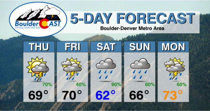
June has begun exceptionally wet across the Front Range and that trend will live on this week with continued cool and rainy weather expected throughout the extended forecast. Wednesday and Thursday look to be the wettest days in the pipeline, but every single day this week will carry at least the risk of scattered storms alongside a minor risk of localized flooding. Things may finally dry out and warm up next week but don’t count on it. Read on for our complete outlook of the weather week ahead in Colorado.

Live View of Boulder

Current Conditions

Live Radar
Latest Smoke Forecast

Recent Premium Posts

BoulderCAST Daily – Tue 07/14/26 | The Front Range Continues to Bake Under Expansive Ridge
🔥 Heat streak continues — Boulder hit 97°F for the third time in …
BoulderCAST Daily – Sun 07/12/26 | Hot weather for a good chunk of the coming week
🥵 🔥 Heat for a good chunk of the week: Upper 90s through …
BoulderCAST Daily – Sat 07/11/26 | Here comes the heat!
🥵 Heat start today: Upper 90s start today and continue well into next …
3-Day Forecast

Trending Content



© 2026 Front Range Weather, LLC