Category: BoulderCAST Daily (Page 69 of 465)

This page contains an index of our BoulderCAST Daily forecast updates. If you are NOT a Premium member, you will only see a tiny sample of this content below. Subscribe to BoulderCAST Premium to gain access to all of our daily forecasts which get published every morning.

Premium BoulderCAST Daily – Sat 03/29/25 | Widespread showers and a few rumbles of thunder through tonight

Asecond wave of low pressure will track through the region this afternoon and especially tonight. It's center is over Idaho, but very warm and moist flow will overspread the state atop light upslope flow at the surface. A cold front moving south from Wyoming and Nebraska will aid low-level lift as well, making for a nice combination for widespread showers …

Premium BoulderCAST Daily – Fri 03/28/25 | Rain chances increase today and especially tomorrow with a chance of storms

Aseries of shortwave troughs will traverse from southwest to northeast over the next 24-48 hours, bringing our weather to an end and increasing rain chances. The rain chances will be highest on Saturday as opposed to today. The first shortwave tonight brings more of a downslope component to the flow on the Plains. As such, rain chances will be highest …

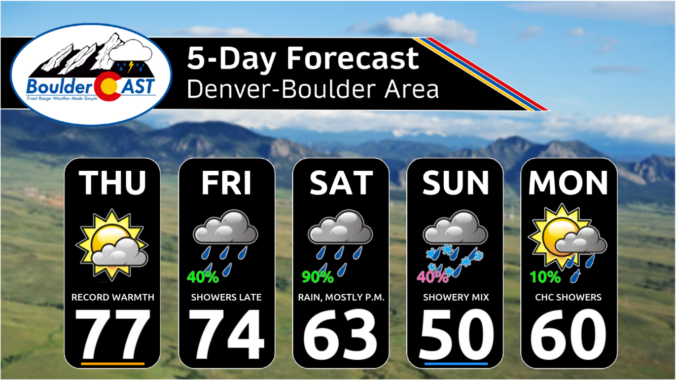
Premium This Weekend in Colorado Weather: Near-record warmth Thursday, but cool & wet weather will take hold for the entire weekend!

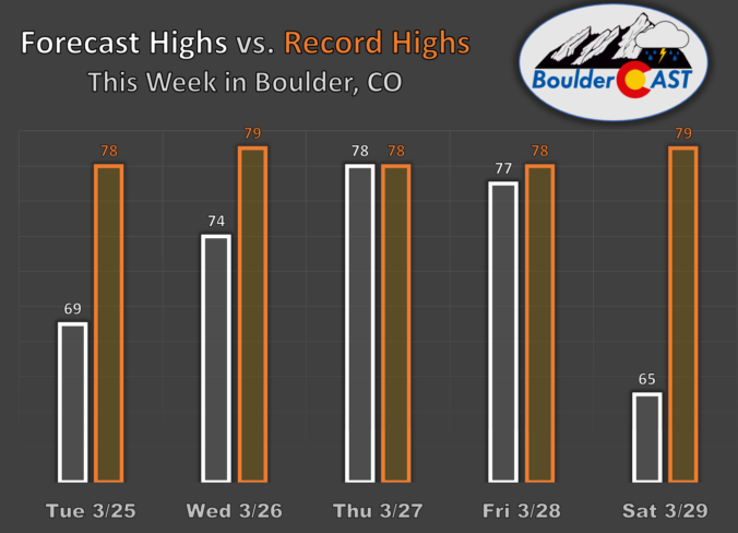
The toastiest day of the week has arrived! The ridge we keep talking about like a broken record is now directly over Colorado, with the warmest airmass of 2025 spreading into the region as we speak. Overnight lows barely dropped below 50 degrees in Boulder despite clear skies and light winds, a sign of the warmth in play right now. …

Premium BoulderCAST Daily – Wed 03/26/25 | Warmer in the 70s with sunshine today, models are trending slightly wetter for the weekend

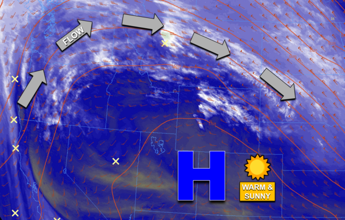
Colorado now rests within the center of the well-advertised ridge of high pressure across the central and southern Rockies. GOES-East shows us the protection offered by the ridge this morning, with copious dry air situated throughout the Great Basin, the Desert Southwest, and of course our glorious state. All of the clouds, precipitation, and faster winds are shoved well to …

Premium BoulderCAST Daily – Tue 03/25/25 | A very likable Tuesday near 70 degrees with sunshine and light winds, the real “heatwave” begins tomorrow

Yesterday's wave clouds ended up being fairly extensive which kept a lid on temperatures during the afternoon hours. This resulted in most of the Denver Metro area staying in the mid to upper 60s, with only some northern areas cracking the 70-degree mark. High temperatures from Monday are shown below. The bigger story was the pesky downslope winds which peaked …

Premium BoulderCAST Daily – Sun 03/23/25 | A breezy next few days

Aset of breezy next few days will be in place across the region. A persistent westerly flow aloft will be nearly perpendicular to the mountain barrier to allow for warm but breezy downslope flow. Gusts this afternoon could reach speeds over 30 mph and on Monday, gusts could exceed 35 mph. As for highs, you'll love the upcoming week. Today, …

Premium BoulderCAST Daily – Sat 03/22/25 | Red Flag Warning in effect today

Acold front will make its way through the region tonight, but not before some warmth and downslope gusty winds develop ahead of it. Westerly low-level flow combined with a jet streak in the upper levels will promote gusty winds between 35 and 40 mph. Highs will also be mild in the middle 60s for most of the Denver Metro area. …

« Older posts Newer posts »