Category: BoulderCAST Daily (Page 68 of 465)

This page contains an index of our BoulderCAST Daily forecast updates. If you are NOT a Premium member, you will only see a tiny sample of this content below. Subscribe to BoulderCAST Premium to gain access to all of our daily forecasts which get published every morning.

Premium BoulderCAST Daily – Sun 04/06/25 | A much warmer end to the weekend

We end the weekend on the milder side. The trough will finally depart into the Southern Plains this afternoon. In its wake, warm ridging will build eastward into the intermountain West. That will spell out a warming trend starting today and maintaining itself for much of the upcoming week. Highs should get to the upper 50s this afternoon. As for …

Premium BoulderCAST Daily – Sat 04/05/25 | Clearing out and slowly warming up

Yesterday's light snow event, focused mainly across western sections of Boulder and Denver and the Foothills will be on its way out fairly quickly by mid-morning today. By later this afternoon and evening, the area of low pressure will be drifting into northern Texas. A trough axis will pass through the Front Range this evening, marking the boundary between dry …

Premium BoulderCAST Daily – Fri 04/04/25 | Areas of light snow today and this evening with highs in the 30s

Asecond storm system will be impacting our region this afternoon and evening and into early Saturday, bringing another round of mostly light snow to the Front Range cities, including the nearby Foothills. The storm system is actually pretty far south, to be honest, with its center over far southwestern New Mexico. Much of that energy will have a tough time …

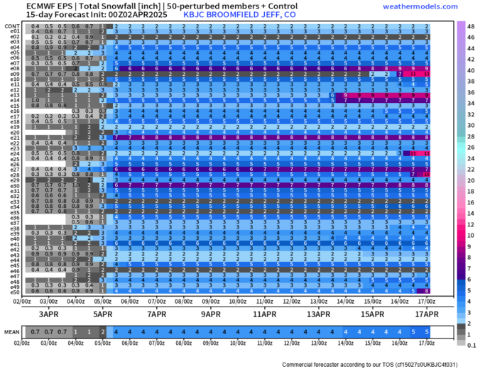
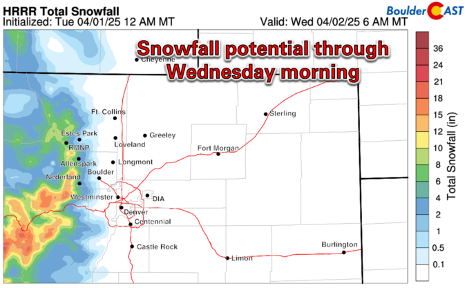
Premium Storm Update – Thu 04/03/25 11:00AM | Rain/snow mix turning to all snow later, a similar event will unfold again tomorrow

Today’s gloomy mix of rain/snow remains on-track for the Front Range, spreading into the area quickly this afternoon before ending around midnight. Most of the actual snow accumulation will occur in/near the Foothills, with minor travel impacts in the higher terrain where slushy roads will occur. Another similar round of mixed precipitation will unfold again Friday afternoon into Friday night, with light accumulations possible as well, especially after the sun goes down Friday evening. We discuss the latest forecast details, inbound snowfall potential and when warmer weather will return.
Continue reading

Premium BoulderCAST Daily – Wed 04/02/25 | A cool & quiet day between systems, but two rounds of snow are brewing to end the week

Yesterday brought a few weak thunderstorms during the afternoon and evening hours, and eventually isolated snow showers overnight which produced a dusting of snow in some areas, but overall Tuesday's precipitation was more miss than hit across the Front Range. https://twitter.com/BoulderCAST/status/1907192067522200039 The western United States remains deeply entrenched in longwave troughing, with the wave that brought us the shower activity …

BoulderCAST Daily – Tue 04/01/25 | Gusty winds with spotty rain/snow showers, wind-blown snow will create difficult travel in the Mountains through tonight

We had a good run, but unfortunately blustery winds return to the forecast today as a storm system intensifies to our north across Wyoming, Montana and the Dakotas. This system is embedded within a broader trough pattern across the western United States, which also includes another developing disturbance digging southward into California today. This system will also impact our area, …

Premium BoulderCAST Daily – Sun 03/30/25 | Cool and cloudy with light spotty showers

Yesterday brought widespread rain across the Front Range of Colorado. Below shows estimated rainfall totals through the early overnight hours, with most places in Denver and Boulder picking up over an inch of rainfall.  Some places reported some light snow mixing in with temperatures dropping into the low to middle 30s, but any real accumulation was hard to come by. …

« Older posts Newer posts »