Category: BoulderCAST Daily (Page 29 of 465)

This page contains an index of our BoulderCAST Daily forecast updates. If you are NOT a Premium member, you will only see a tiny sample of this content below. Subscribe to BoulderCAST Premium to gain access to all of our daily forecasts which get published every morning.

Premium BoulderCAST Daily – Fri 03/20/26 | A very warm Friday ahead of high-end fire danger and likely 90° readings on Saturday

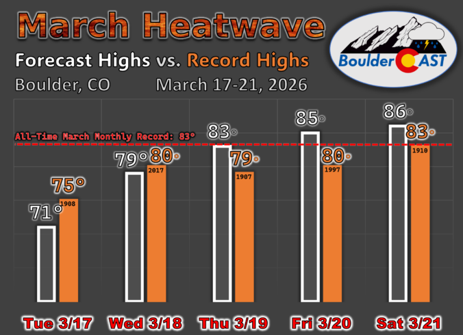
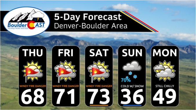
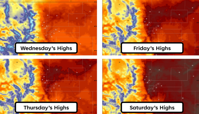
As expected, Boulder and Denver both set new all-time March monthly record highs on Thursday reaching a toasty 85°F during the afternoon hours. This broke Boulder's prior March best of 83° set back in 1910. Sadly, this record high won't even last 24 hours, with a slightly warmer day expected for our Friday. The map below shows the long-term weather …

Premium BoulderCAST Daily – Wed 03/18/26 | Extreme Southwest heat dome targets Colorado with temperature records set to be obliterated the rest of the week

The final days of winter are about to behave more like midsummer along the Front Range. An exceptionally strong ridge of high pressure is locking in over the American Southwest for several days, funneling hot, bone‑dry air directly into Colorado through Saturday. As of Wednesday morning, the ridge is already evident on water‑vapor imagery, centered over central California and rapidly …

Premium BoulderCAST Daily – Tue 03/17/26 | Historic ridge begins its trek inland today kicking off a multi‑day heatwave throughout Colorado

AAfter a legitimately chilly Monday — late‑day temperatures scraped into the lower 50s — we now step directly into what will become a multi‑day, mid‑March heatwave as a historically strong ridge of high pressure begins sliding inland. This ridge is not just going to bring us a garden‑variety warm spell. As we've been advertising for nearly ten days now, this …

Premium BoulderCAST Daily – Sun 03/15/26 | Much Colder Today But Very Warm This Coming Week

Astrong cold front has pushed through the region during the overnight hours into earlier this morning. Along with that, we have dropped much colder, along with a band of quick-hitting snow over the Front Range. Below shows the radar animation from earlier this morning. Much of the snow will taper off by mid-morning. Preliminary amounts range from a half inch …

Premium BoulderCAST Daily – Sat 03/14/26 | Extreme Fire Danger followed by Cold/Snow/Wind Sunday

We discussed quite extensively in our post yesterday about the extreme fire danger today, with Xcel Energy taking critical steps to protect infrastructure in the case of an out of control fire. All of the meteorology ingredients will combine with very warm/dry fuels to make for an extremely critical fire danger today. Red Flag Warnings are in full effect for …

Premium BoulderCAST Daily – Fri 03/13/26 | Red Flag Warning Conditions on Friday the 13th

Our Friday the 13th will actually be scary in terms of the weather pattern. Below shows the highlights across the Front Range today. Red Flag Warnings are once again in effect for much of eastern Colorado, including the Denver Metro area. High Wind Warnings are in effect for the Foothills, while Winter Weather Advisories are in effect for the mountains …

Premium BoulderCAST Daily – Thu 03/12/26 | This is the first of three consecutive critical fire weather days as gusts reach up to 100 MPH in the Foothills

The long‑signaled mountain wave windstorm is already underway before sunrise across the Foothills west of Denver and Boulder. Stations between 7,500 and 9,000 feet are routinely gusting 60–70 MPH as the wave begins to organize. Downslope amplification will strengthen steadily through the day, with the core of the event expected from roughly 10 AM to 8 PM, when peak gusts …

« Older posts Newer posts »