Category: BoulderCAST Daily (Page 194 of 465)

This page contains an index of our BoulderCAST Daily forecast updates. If you are NOT a Premium member, you will only see a tiny sample of this content below. Subscribe to BoulderCAST Premium to gain access to all of our daily forecasts which get published every morning.

Weekend Weather Outlook: April 28, 2022

The ridge of high pressure which has kept us warm and mostly dry the last few days has pushed off to the east with an axis now located over the heart of the Midwest. West of this ridge, southwest flow has been around since yesterday in our area with a stream of moisture funneling into Wyoming and northern Colorado right …

BoulderCAST Daily – Wed 04/27/22 | A warm & cloudy day with a small chance of sprinkles

Amostly quiet day is on-tap for Front Range Colorado with a ridge axis very much nearby. The graphic below shows today's large-scale atmospheric setup. Since the ridge axis has passed to our east, southwest flow has kicked in across the Centennial State. This will allow for well above normal temperatures and will also advect in some moisture aloft (think lots …

BoulderCAST Daily – Tue 04/26/22 | Warming up as a ridge nestles into the area

Above normal temperatures return to the forecast today as an upper-level ridge slides into the area. The GOES-East infrared satellite animation below shows clear skies from Utah to Kentucky, with the ridge axis noted to be across western Colorado this morning. Today will be beautiful and warm with light afternoon breezes gusting 10-15 MPH. Expect lots of sunshine early, but …

BoulderCAST Daily – Sun 04/24/22 | Increasing clouds with rain/snow developing in the Foothills, a slight chance of rain showers in the western Metro

Infrared satellite imagery shows an impressive lingering storm system across the Dakotas this morning. Yes, this is yet another low pressure the produced blizzard conditions well to our north. We've had just wind and resulting high fire danger across the Front Range so far over the last 48 hours. As you can see in the animation above, there is some …

BoulderCAST Daily – Sat 04/23/22 | Another breezy day with wind gusts approaching 45 mph

The strong low pressure system has exited to our northeast, located over western South Dakota this afternoon. This large system is creating havoc across the midsection of the country, including our area. While the system has moved east, we are still on the southwestern periphery of the low. That side of the system still favors a strong northwesterly downslope wind …

BoulderCAST Daily – Fri 04/22/22 | Extreme Fire Conditions Today

This may sound like a broken record as we posted yesterday about the extreme fire danger today. But just to reiterate, extreme caution is urged today with strong gusty winds developing, low relative humidity, dry fuels, and warm temperatures in the lower 80s. The image below shows the very low RH values this afternoon, well below 15%. A surface low …

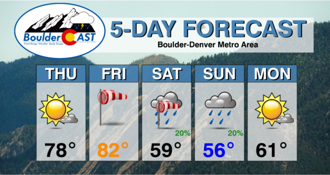
Weekend Weather Outlook: April 21, 2022

⦁❶⦁ Lesser fire concerns Thursday as winds relax and highs climb into the upper 70s under sunny skies

⦁❷⦁ A very strong storm will move across the Rockies on Friday creating a slew of weather impacts for the state — extreme fire danger, high winds, dust storms, mountain snow and severe thunderstorms

⦁❸⦁ WARNING: Extremely high fire danger Friday afternoon and evening with wind gusts 40+ MPH everywhere in the Front Range

⦁❹⦁ Cooler temperatures in the 50s with more clouds and a chance of rain showers both days this weekend

Continue reading

« Older posts Newer posts »