Category: Climatology (Page 12 of 66)
These posts contain information about the long-term weather patterns of Boulder County. Potential topics may include 30-day weather outlooks, El Nino/La Nina, and seasonal forecasts. You will find less about the day-to-day weather, with more focus on longer trends and patterns.
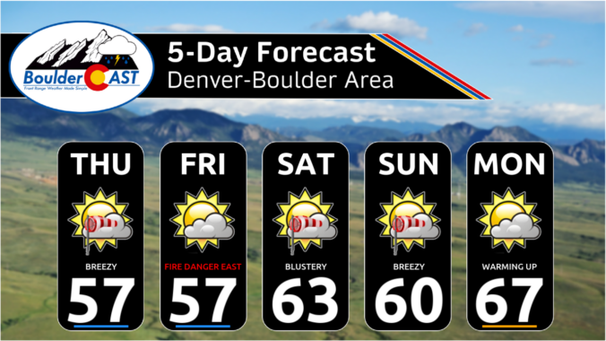
The week ahead will remain largely dry across the Front Range thanks to the slow passage of a strong ridge of high pressure aloft. Gusty downslope winds on Monday will relax and transition into a mid-week heatwave with record highs up for grabs across multiple days. However, unsettled weather is brewing for the upcoming weekend with decent rain chances for the lower elevations and a few snowflakes for the higher Foothills. Read on for all the details.
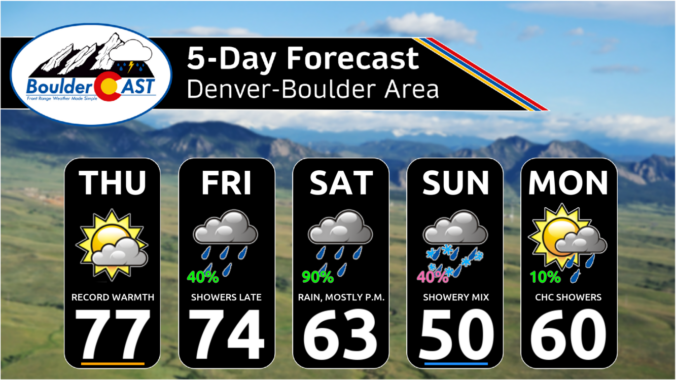
Colorado’s weather this week promises to be a mixbag, kicking off with near-record warmth and high fire danger on Monday, followed by a dramatic cool-down with a chance of rain and snow heading into midweek. As we officially transition into the spring season, be prepared for gusty winds, fluctuating temperatures, but only minor precipitation—with an active yet relatively dry forecast for the Denver-Boulder area this week. Read on for all the details.
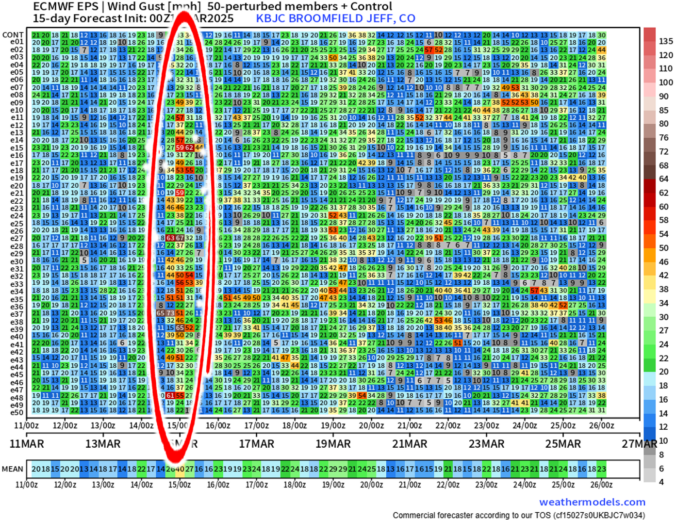
The well-advertised dip in the jet stream set to bomb out across eastern Colorado is still very much on-track to end the work week. The forecast for this springtime beast has remained largely unchanged since our last forecast update on Monday when we detailed that this monster storm would primarily be a wind-maker for us. We discuss which parts of Colorado will see the strongest winds, where the limited rain and snow will fall, and the ensuing mess this storm will cause as it races across the nation in the days ahead. Read on for the latest details.
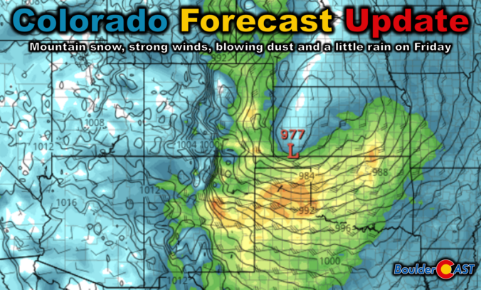
As we head into the second week of March, Mother Nature will offer up a wide range of weather in the Front Range, including elevated fire danger, unseasonably warm temperatures, and an impressively strong spring storm system by Friday. The late-week storm will usher in Mountain snow and widespread strong winds to the state. Depending on how things evolve, blizzard conditions and blowing dust may be an issue east of Denver, but things aren’t looking too bad in our immediate area. Read on for all the details.
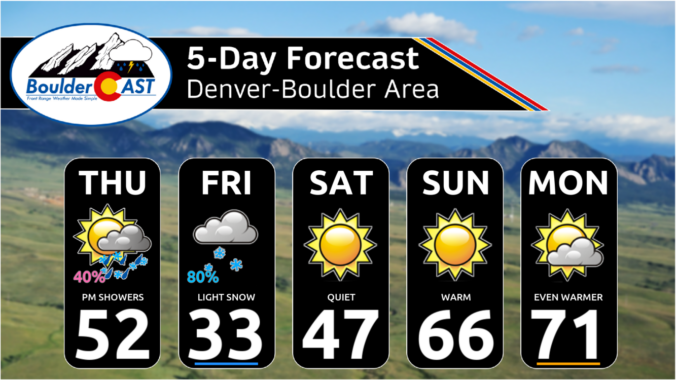
Two different low pressure systems will impact Colorado to end the work week, but unfortunately they will both largely miss the Front Range — one too far north and the other too far south. The Boulder-Denver area will still catch some light precipitation and colder temperatures, but potential snow accumulations are expected to be light and remain mostly west of Interstate 25 and in the Foothills. Things clear out nicely just in time for the weekend, with sunny skies and 70-degree temperatures not far off. Here’s the latest.

Live View of Boulder

Current Conditions

Live Radar

Recent Premium Posts

BoulderCAST Daily – Sun 01/11/26 | A mild Sunday with readings reaching the 50s
🌤️ Mild & Melty Sunday: Light winds and patchy clouds, with lingering snowpack …
BoulderCAST Daily – Sat 01/10/26| Widespread sunshine and moderating temperatures this weekend as our recent snow melts off
🌤️ Calm Saturday: Winter storm systems have departed the state, leaving behind a …
BoulderCAST Daily – Fri 01/09/26| Snow ends quickly this morning with a quieter weekend in store
❄️ Overnight snow bands: A second push of upslope after midnight sparked narrow …
3-Day Forecast

Trending Content

© 2026 Front Range Weather, LLC