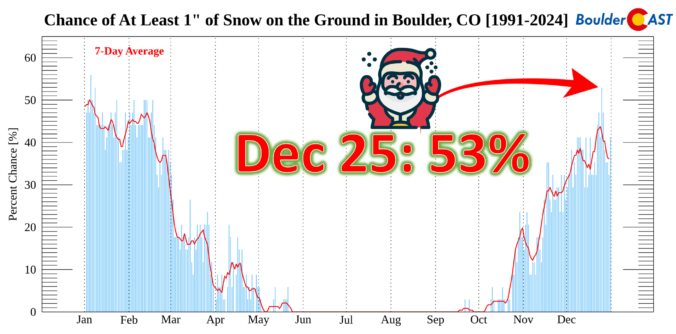
This Christmas will be a scorcher across the Front Range with temperatures soaring towards record highs near 70 degrees, but snow is often part of the equation here on Christmas, whether falling or on the ground. We take a broader look at White Christmas occurrences in Boulder’s historical record and discuss why Christmas Day, out of all days, has one of the highest probabilities of snow on the ground here.
Author: BoulderCAST Team (Page 4 of 48)
This post had major contributions from at least two members of our team. The more meteorologists the better, right?
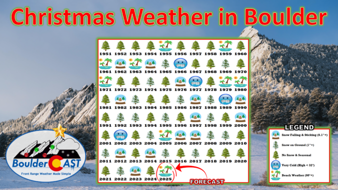
December has been anything but typical along the Front Range, with Boulder shattering warmth records and enduring weeks of bone‑dry weather that have fueled fire danger and stressed our local trees. As we head into Christmas, the holiday will feel more like patio season than sledding weather, with record highs likely and no snow available outside of the Mountains. But don’t pack away the winter gear just yet—a sharp cooldown and even a chance for light snow are on the horizon this weekend. We take a closer look this historically warm and dry December, the scorching Christmas forecast, and peek ahead to what’s next.
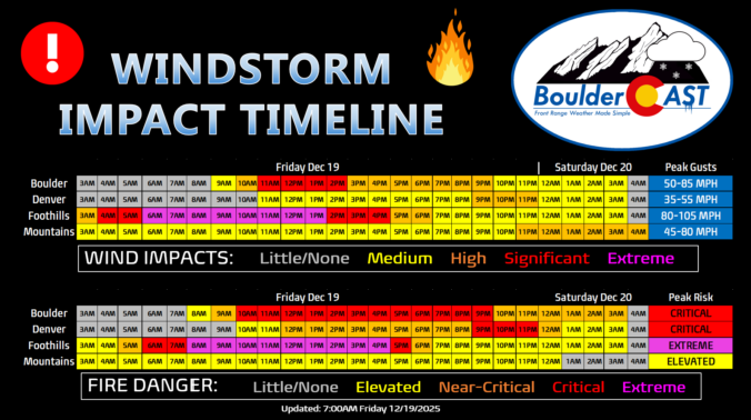
Updated (7AM Friday 12/19): Updated based on latest guidance adjusting timings and intensity of wind/fire impacts, and also made a stronger case for the extreme winds (and fire danger) to potentially stay mostly in the Foothills or very close to there. Lowered wind/fire risk in Boulder proper. This is still a very dangerous situation.
—
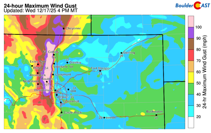
Boulder, the far western suburbs of Denver, and the Foothills are bracing for yet another powerful mountain wave windstorm Friday, with gusts likely topping 75–100 MPH and, this time, extreme fire danger will be layered on top. Forecast models show the strongest winds during the morning into the afternoon, coinciding with critically dry air and record‑challenging warmth. Power shutoffs, downed trees, and blowing dust are all on the table, but the bigger story is the fire risk—conditions are primed for rapid spread if any ignition occurs. Fortunately it now appears that most of the intense winds will stay largely in the Foothills, but there is some uncertainty how far downhill and east they will reach. Read on for the full breakdown of timing, impacts, and what you need to know to stay safe. We also briefly review the damaging wind event that just occurred on Wednesday.
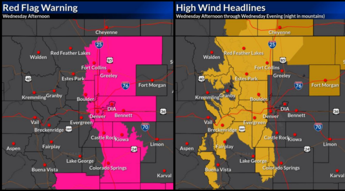
If you thought Monday’s sunshine was the start of a quiet week, think again. The next 48 hours will bring a dramatic shift in our weather —starting with breezy but pleasant conditions Tuesday, then escalating into a powerful downslope windstorm with heightened fire danger on Wednesday. And just when you think it’s wrapping up, a sharp cold front will crash the party with blustery conditions and even a chance for rain and snow Wednesday evening.
We’ll break down what to expect, where the strongest winds will hit, and how this event stacks up against the day of the Marshall Fire. Plus, we’ll look at the potential for Xcel power shutoffs (spoiler: it’s going to be happen).
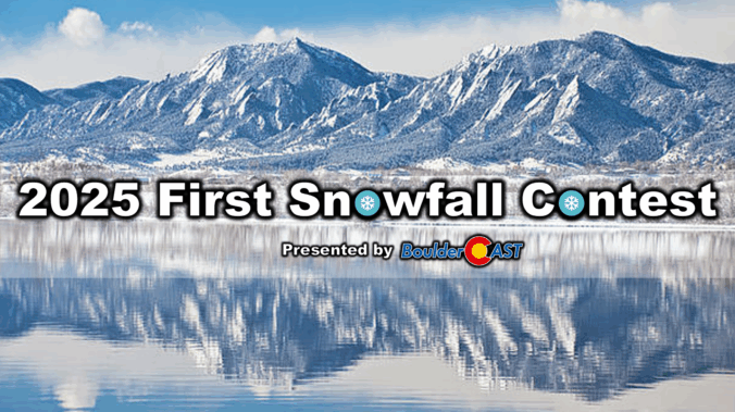
Apologies for the delay, but with Boulder’s record-shattering latest first snow of the season officially in the bag back on November 29th, it’s time to announce the winners of our 11th Annual First Snowfall Contest. Were you one of them?

We offer the option to purchase Gift Memberships of BoulderCAST Premium for your friends and family. There’s no better way to surprise your favorite weather enthusiast and also help support the BoulderCAST team!
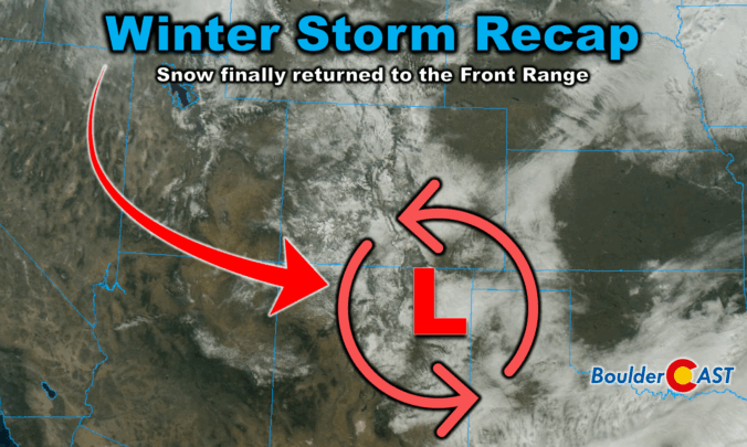
Winter finally showed up in style this week along the Front Range. After a sluggish start to the season, our first true snowstorm delivered nearly 18 hours of steady flakes, painting Boulder, Denver, and much of Colorado in white. But this wasn’t just a simple upslope event—there were some fascinating atmospheric twists that kept the snow machine running longer than expected. We review the storm setup and snowfall totals which greatly favored the western side of the Metro area including Boulder.

Live View of Boulder

Current Conditions

Live Radar

Latest Smoke Forecast

Recent Premium Posts

BoulderCAST Daily – Sun 07/12/26 | Hot weather for a good chunk of the coming week
🥵 🔥 Heat for a good chunk of the week: Upper 90s through …
BoulderCAST Daily – Sat 07/11/26 | Here comes the heat!
🥵 Heat start today: Upper 90s start today and continue well into next …
BoulderCAST Daily – Fri 07/10/26 | The heat builds into the weekend
⛈️ Storms around today: A weak impulse of energy favors some isolated storms …
3-Day Forecast

Trending Content

© 2026 Front Range Weather, LLC