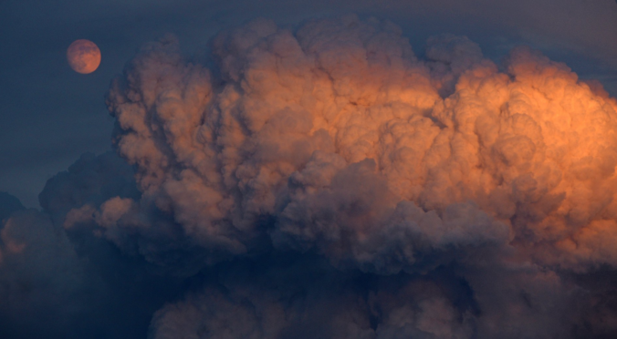
June 2021 began as one of the hottest and driest on record for the area, but ended on a cool and rainy note! Other weather highlights during the month included a slew of new wildfires across the Western Slope, a highly photogenic landspout tornado, multiple heatwaves, and poor air quality from near and distant wildfires. Here’s a quick and colorful recap of our weather during June and how it relates to climatology.
Author: BoulderCAST Team (Page 25 of 45)
This post had major contributions from at least two members of our team. The more meteorologists the better, right?
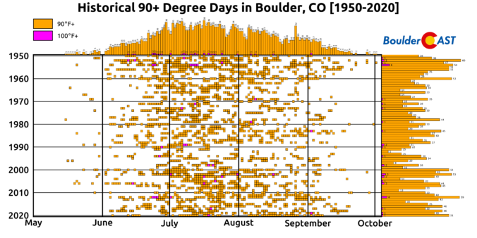
As the heatwave reaches peak intensity on Wednesday, Boulder is well-positioned to obliterate the existing daily record high temperature for the date, maybe even before the lunch hour! However, increasing smoke from distant wildfires, more widespread clouds and outflows from developing showers could keep the city from hitting the elusive century mark. We review the climatology of rare triple digit heat, discuss why Denver is often several degrees warmer than Boulder on days like this, and take a look ahead to when the heat will end.
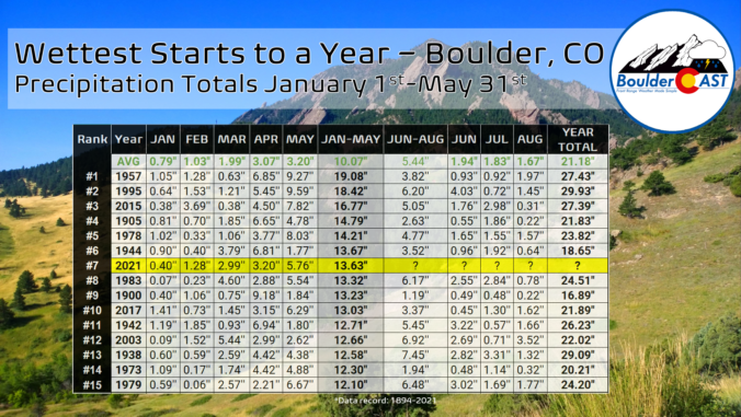
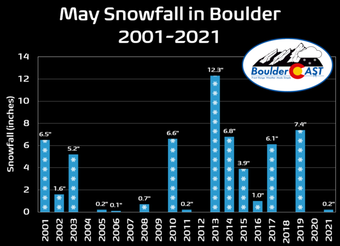
Front Range weather during the month of May was certainly busy! We got our first taste of summertime thunderstorms, including accumulating hail in spots. There were numerous upslope storms; a few even turned cold enough for snow in Boulder and Denver. La Niña dissipated and the drought showed continued signs of improvement. Here’s a quick and colorful rundown of our weather during May 2021, the notable atmospheric highlights and how it all relates to climatology.
The weather for Memorial Day Weekend will not be pleasant across the Front Range unfortunately. A cold front is set to arrive early Saturday paving the way for a relatively cold and gloomy holiday weekend. Will the weekend be a total washout? How much rain can the area expect? When and where will a little snow mix in? Read on to find out!
Anywhere from 0.5 to 1.5″ of liquid fell across the Front Range in the past few days, including up to 15″ of snow in the Foothills. There was also some accumulating snow across the lower elevations, too. Let’s take a look at the snow totals from the last few days!

Our weather during the month of April was very fickle. Eleven consecutive warm days kicked off the month but were quickly followed by a prolonged period of cold and snow on the heels of several Arctic outbreaks. The important result, however, was a significant improvement in the drought across northeast Colorado. Here’s a quick and colorful rundown of our weather during April 2021 and how it relates to climatology.

As 1 to 2″ of rain fell across the lower elevations this week, snow was falling above 6500 feet elevation across the Front Range where temperatures were cold enough. Let’s take a look at the snow totals from a storm that kicked off the month of May!
A review of the snow totals from Tuesday night into Wednesday as snow fell above 6000 feet elevation across the Front Range (with just plain rain in Boulder and Denver).

Live View of Boulder

Current Conditions

Live Radar

Recent Premium Posts

BoulderCAST Daily – Tue 01/13/26 | A thick blanket of high clouds won’t stop us from reaching the 60s again
☁️ Thick cloud deck overhead — Moisture streaming in aloft brings widespread mid‑ …
BoulderCAST Daily – Sun 01/11/26 | A mild Sunday with readings reaching the 50s
🌤️ Mild & Melty Sunday: Light winds and patchy clouds, with lingering snowpack …
BoulderCAST Daily – Sat 01/10/26| Widespread sunshine and moderating temperatures this weekend as our recent snow melts off
🌤️ Calm Saturday: Winter storm systems have departed the state, leaving behind a …
3-Day Forecast

Trending Content

© 2026 Front Range Weather, LLC