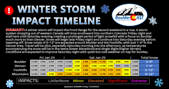
We haven’t really seen much melting of the more than a foot of snow that fell last weekend in Boulder, but additional white stuff is indeed on the way this weekend! A slow-moving storm system will bring relatively light but long-lasting snow to the area Friday night into Saturday night, with a heavy focus on the northern Front Range this time (Boulder and Larimer Counties). Some locations could see upwards of a foot of snow as temperatures plummet back into the teens for Saturday. Let’s take a look!
Author: Ben Castellani (Page 32 of 303)
Ben grew up in southwestern Pennsylvania and holds both a bachelor's and a master's degree in Meteorology, the latter being from CU Boulder. His hometown received nearly three feet of snow from the Storm of the Century back in March of 1993, sparking his initial interest in impactful weather. Ben currently works on remote sensing and data analysis software at NV5 Geospatial Software in Boulder.
Our anticipated Arctic cold front is pushing southward across northern Wyoming right now and is on-track to arrive into the Denver area this afternoon. Snowflakes will be slightly delayed, but are expected to quickly develop early this evening impacting at least some of the commute window as travel turns very treacherous through the evening. The latest model data points to a slightly more impactful snow event unfolding, especially for Boulder County. We’ve increased snow totals in these areas. We also discuss the temperature outlook for the rest of the frigid holiday weekend ahead.

This week will feature a mixture of calm and chaos in Front Range Colorado! While the early part of the week will be relatively quiet with cool temperatures, a significant change in our weather is brewing for Friday. An Arctic blast is set to slam eastern Colorado during the late-day period, ushering in the coldest air of the season this weekend alongside widespread snowfall. Enjoy the sunshine and mild conditions the next several days, but begin preparations for the deep freeze and snowy conditions ahead!
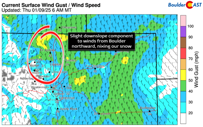
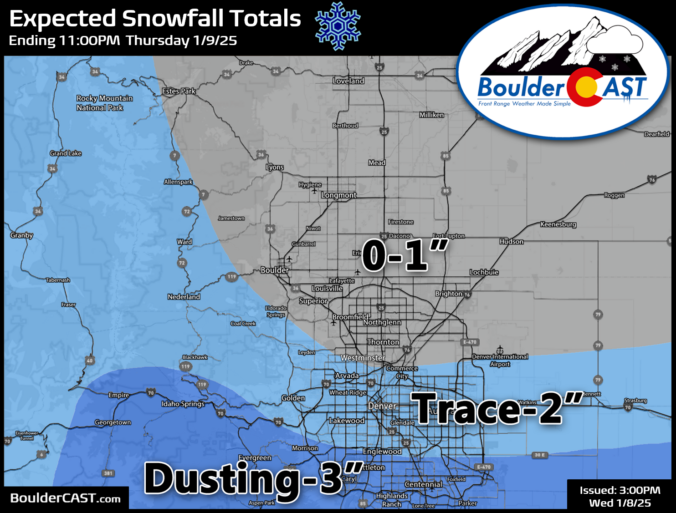
Snow has quickly developed this morning across southern portions of the Denver Metro area, while things remain mostly dry throughout Boulder County under the protection of downslope flow. We take a look at current conditions across the region, the expected blustery wind speeds for today, and how much snow will fall throughout the morning.
Light but fluffy snow is falling across the entire Front Range this morning. In today’s update, we take a look at current travel conditions around the area, how much snow has already fallen and what is still to come based on the latest model data. Plus a look at just how cold it will get for the night ahead with clearing skies and fresh snow on the ground.

Live View of Boulder

Current Conditions

Live Radar

Recent Premium Posts

BoulderCAST Daily – Sat 05/30/26 | A stray shower today as most activity resides well east of Denver
🌦️ Spotty showers today, mainly well east of the Denver Metro area, where …
BoulderCAST Daily – Fri 05/29/26 | A Marginal Risk of Severe Isolated Storms
🌦️ Spotty showers this afternoon, mainly noon and 4 PM, with highs in …
This Weekend in Colorado Weather: Unsettled but Manageable as Low-End Storm Chances Hang Over the Front Range
🌎 Omega block holds through early next week, but slowly shifts toward the …
3-Day Forecast

Trending Content

© 2026 Front Range Weather, LLC