Author: Ben Castellani (Page 33 of 358)

Ben grew up in southwestern Pennsylvania and holds both a bachelor's and a master's degree in Meteorology, the latter being from CU Boulder. His hometown received nearly three feet of snow from the Storm of the Century back in March of 1993, sparking his initial interest in impactful weather. Ben currently works on remote sensing and data analysis software at NV5 Geospatial Software in Boulder.
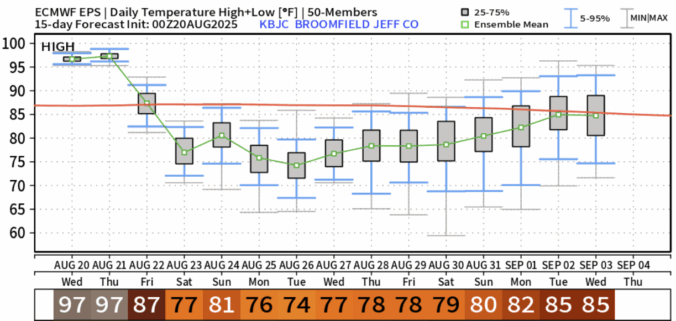
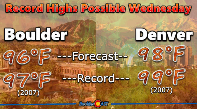
Premium BoulderCAST Daily – Wed 08/20/25 | Two more hot days, but there are hints of autumn in the extended

It’s another scorcher on tap today across the state as the Four Corners high keeps its grip locked in through Thursday. That ridge is doing what it does best—suppressing vertical motion and drying out the atmosphere. So for the Front Range, rain chances are basically nonexistent. The good news? Winds are staying tame under this setup, which will help keep …

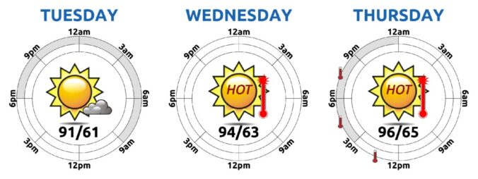
Premium BoulderCAST Daily – Tue 08/19/25 | Heat steadily intensifies through Thursday, but change is taking shape for the weekend

The Front Range is leaning hard into a hotter, drier stretch today as high pressure tightens its grip. If you peek at this morning’s GOES-East water vapor imagery (with 500mb winds overlaid), you’ll spot the developing high centered near the Colorado–New Mexico border. It’s still a bit disorganized — scraggly, even — but it’s gaining strength. By tomorrow, it’ll be …

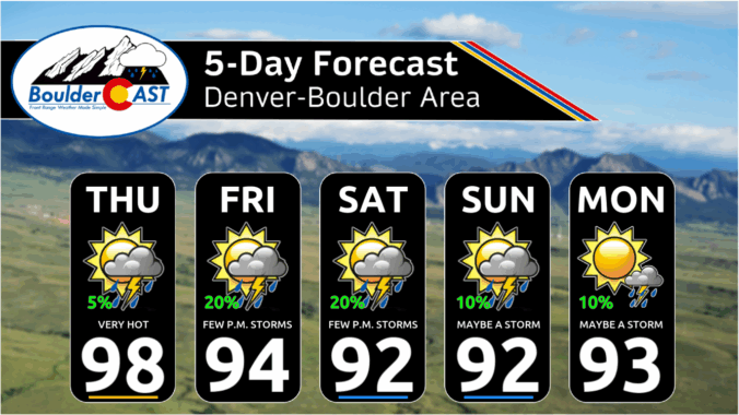
This Week in Colorado Weather: August 18, 2025

If you’ve been quietly rooting for a late-season monsoon comeback, it might be time to recalibrate. Boulder’s summer has been historically dry, and this week won’t offer much relief, at least initially. A persistent ridge of high pressure is set to lock in more heat and keep moisture at bay. But don’t tune out just yet—there’s a subtle pattern shift coming that could open the door to cooler temps and better storm chances by the weekend. Let’s take a closer look.
Continue reading

Premium This Weekend in Colorado Weather: The heat and smoky haze stick around through the weekend with only low-end storm chances

Well, I didn’t expect our tally of 100-degree days to climb this week, but here we are. Boulder officially hit 100°F yesterday afternoon, smashing the previous daily record by a full three degrees. That makes it only the eighth time we’ve seen triple digits in August since the late 1800s—and the first time we’ve logged two of them in the …

Premium BoulderCAST Daily – Wed 08/13/25 | Fire danger on the rise as temperatures soar to near-record levels

We’re heading into a stretch of relatively quiet weather—at least on the surface—as a shortwave ridge slides from Southern California today toward Missouri by Saturday. As this ridge moves east, Colorado transitions into a hotter, stormier pattern thanks to mid-level moisture sneaking back in from the south. That shift kicks off today. There’s just enough moisture overhead to spark some …

Premium BoulderCAST Daily – Tue 08/12/25 | A picture-perfect Tuesday ahead of another heatwave; Stage 1 fire ban goes into effect today

Today’s shaping up to be another gorgeous summer day across the Front Range, thanks to a cool and dry northwest flow lingering over Colorado. Satellite imagery from GOES-East confirms this tranquil setup, but don’t get too comfortable — a strong high-pressure system parked over California and Nevada is on the move. By tomorrow into Thursday, it’ll settle over us, bringing …

This Week in Colorado Weather: August 11, 2025

After a weekend of thunder and cooler air, the Front Range is catching its breath under clear skies and a brief spell of dry northwest flow. But don’t get too comfortable—heat, haze, and a few storm chances are already lining up for a return later this week. In this update, we break down the shifting ridge pattern, what it means for temperatures, and when wildfire smoke and monsoon moisture might make a comeback.

Continue reading

« Older posts Newer posts »