


Author: Ben Castellani (Page 177 of 358)
Ben grew up in southwestern Pennsylvania and holds both a bachelor's and a master's degree in Meteorology, the latter being from CU Boulder. His hometown received nearly three feet of snow from the Storm of the Century back in March of 1993, sparking his initial interest in impactful weather. Ben currently works on remote sensing and data analysis software at NV5 Geospatial Software in Boulder.
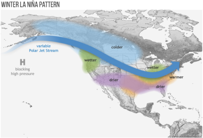
For the first time in three years, La Niña conditions have developed and are expected to last through the upcoming winter. We discuss the forecast, remind you what La Niña actually is, and explain the potential impacts La Niña will have on Colorado for the rest of autumn. If you like pie charts, box-and-whisker graphs and/or 3-D representations of ocean temperatures, this post is most definitely for you!


What are our predictions for the rest of fall and the snowfall potential this winter as La Niña takes hold? What happened in the Front Range during the last few La Niñas? Does 2020’s hurricane season so far hold a candle to the hyper-active one back in 2005? Listen to find out!

Live Radar

Trending Content


Recent Premium Posts

This Weekend in Colorado Weather: The Quiet Pattern Ends as Storm Activity Picks Up Across the West
After weeks of sunshine, mild afternoons, and storm systems repeatedly missing Colorado to …
BoulderCAST Daily – Wed 11/11/26 | Mild Days Ahead, But There Are Signs of a More Active November Soon
☀️ Warm & Quiet — Sunshine dominates through Thursday with highs rising from …
BoulderCAST Daily – Tue 11/10/26 | Clouds Increase Today, But Colorado’s Dry Pattern Rolls On
🌤️ A Few More Clouds Today – Mountain wave clouds are developing along …
© 2026 Front Range Weather, LLC