Author: Ben Castellani (Page 176 of 358)

Ben grew up in southwestern Pennsylvania and holds both a bachelor's and a master's degree in Meteorology, the latter being from CU Boulder. His hometown received nearly three feet of snow from the Storm of the Century back in March of 1993, sparking his initial interest in impactful weather. Ben currently works on remote sensing and data analysis software at NV5 Geospatial Software in Boulder.
BoulderCAST Daily – Thu 10/15/20 | Much cooler with increasing sun

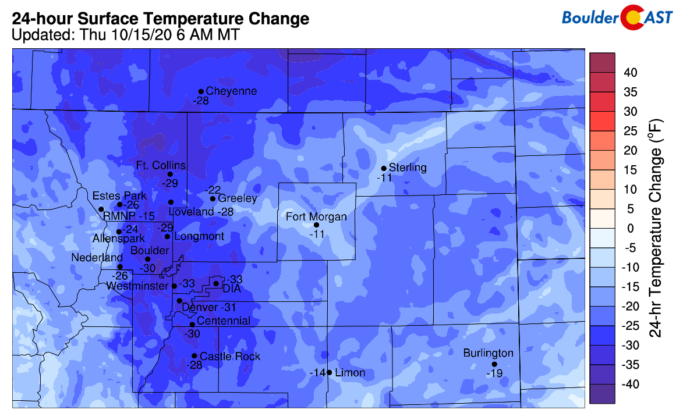
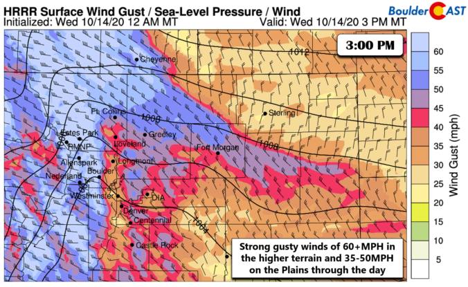
MDetailed Forecast Discussion: uch cooler temperatures are noted today following the passage of yesterday's cold front. We're in the middle 30's this morning, compared to the lower 70's just 24 hours ago. This is a change of nearly 35 degrees. As expected, the winds were indeed howling on Wednesday with frequent gusts of 30 to 50 MPH reported across the …

BoulderCAST Daily – Wed 10/14/20 | Warm & blustery!

WDetailed Forecast Discussion: e're starting out very mild this morning across the Metro area with temperatures near 70 degrees, even before sunrise. This extreme overnight warmth for mid-October is a result of the pre-frontal airmass, westernly downslope flow, and a thick wave cloud blanketing portions of the area aloft. Here's a look at current temperatures across the region as of …

BoulderCAST Daily – Tue 10/13/20 | A great October day, but a gusty front arrives tomorrow

HDetailed Forecast Discussion: appy Tuesday! Outside of a few mountain wave clouds yesterday, we got unobscured views of the fresh snow in the Mountains that fell on Sunday from GOES-16. The animation during the day yesterday is shown below. As we detailed in our weekly outlook, today will be another rather uneventful weather day across the state with predominantly dry …

BoulderCAST Daily – Thu 10/08/20 | Sunny & smoky with near-record warmth

WDetailed Forecast Discussion: arm, mostly sunny and dry conditions will reside across the Front Range through Saturday with highs in the 80's. The biggest forecasting challenge in the coming days surrounds the lingering smoke loaded into the atmosphere across much of Colorado. Of course the massive fires burning to our northwest will continue to produce billowing smoke plumes each afternoon …

BoulderCAST Daily – Wed 10/07/20 | High pressure is on top of us

BDetailed Forecast Discussion: oulder snatched up yet another record in 2020 yesterday soaring to a new historical daily high of 86°F. Little changes will occur in the forecast today as the center of high pressure is now situated directly over Colorado. Essentially we're looking at an identical airmass and conditions to what we saw on Tuesday. The only change worth …

BoulderCAST Daily – Tue 10/06/20 | Record highs possible though not likely through Saturday

IDetailed Forecast Discussion: f you recall from our weekly outlook posted yesterday, the ridge axis to our west was oriented northwest to southeast across the Four Corners region. Today, the ridge is showing initial signs of weakening as it flattens out, now lined-up almost directly west to east. This flattened ridge will continue to slide eastward in the coming days. …

This week in Colorado weather: October 5, 2020

It will feel like August, not October, this week as the same old pesky ridging pattern holds across the western United States. As a result, we’ll largely see a continuation of dry and unseasonably warm weather across the Front Range as many days flirt with record high temperatures. Read on for our complete outlook of the week ahead, including discussion of when our next chance of precipitation may edge into the forecast.

Continue reading

« Older posts Newer posts »