Author: Ben Castellani (Page 166 of 301)
Ben grew up in southwestern Pennsylvania and holds both a bachelor's and a master's degree in Meteorology, the latter being from CU Boulder. His hometown received nearly three feet of snow from the Storm of the Century back in March of 1993, sparking his initial interest in impactful weather. Ben currently works on remote sensing and data analysis software at NV5 Geospatial Software in Boulder.
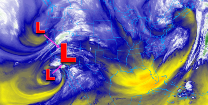
One thing is for sure, a prolonged period of cold and unsettled weather will take hold of the Front Range Wednesday morning into Friday. A mash-up of rain, snow, and freezing drizzle will intermittently impact the area during this timeframe. Overall precipitation rates will be light, but the long duration could lead to light snow accumulations by Friday morning. In this update, we talk tumbling temperatures, rain/snow/ice timing, and potential snow accumulations.
*PREMIUM* STORM UPDATE (7:00 AM Thu 11/21): Don’t be fooled by the lull in the action… There is still more light snow to come! READ HERE
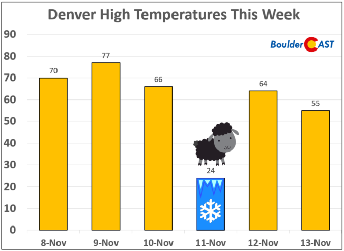
From record warmth over the weekend, to snow and bitter cold on Veterans Day, to the rebound back into the 60’s just one day later…it’s been quite a wild week in Colorado weather. We explain why Monday’s cold temperatures have joined rare company in Denver’s historical record. The reason may surprise you.

We hope you enjoyed the snowy and cold Veterans Day holiday! We first review the totals from the light snow event yesterday, then take a look at the weather transpiring the rest of the week. Things get interesting just in time for the weekend!

Live View of Boulder

Current Conditions

Live Radar

Recent Premium Posts

BoulderCAST Daily – Sun 05/03/26 | Beautiful weather will transition to late-spring snow by Tuesday!
☀️ Warm Start: Expect a quiet and pleasant start to the week, with …
BoulderCAST Daily – Sat 05/02/26 | A pleasant and warm first weekend in May
☀️Warming up for the first weekend in May, with upper 60s to near …
BoulderCAST Daily – Fri 05/01/26 | Warming up this weekend
🌡️ Warming up this weekend, from the upper 50s-60 today to the upper …
3-Day Forecast

Trending Content

© 2026 Front Range Weather, LLC