For the second weekend in a row, a winter storm will be impacting the Front Range with very cold temperatures, freezing drizzle, and snow. We discuss when the cold air will arrive, potential ice and snow amounts, and when temperatures will return to normal again.
GENERAL SET-UP
Mild temperatures have been the primary story over the last several days for our region. This will continue for Friday. An enormous wave cloud currently shadows the Metro area (see below), but even still, temperatures will once again reach near 60 degrees across the lower elevations and climb to the upper 40’s in the Foothills.

GOES-East visible satellite animation of a giant wave cloud over the Metro area Friday morning
As the models were hinting at earlier in the week, the pleasantries come to an conclusion later tonight. A cold front will spill into northeast Colorado this evening with temperatures falling into the 30’s following the frontal passage. The current timing on the front is between 9PM and midnight into Boulder.
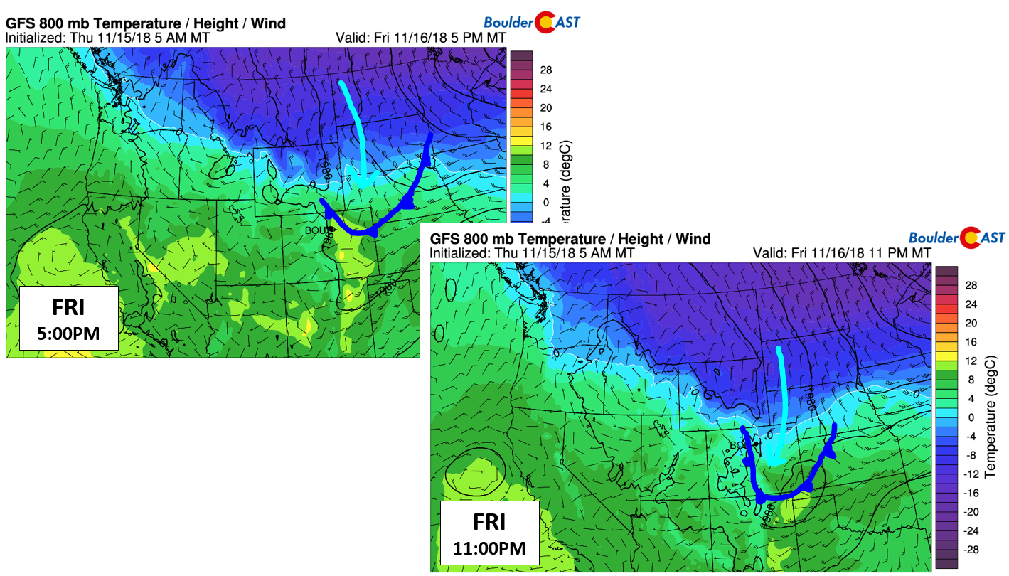
GFS 800 mb temperature and wind forecasts for 5PM Friday (top left) and 11PM Friday (bottom right) showing the passage of the surface cold front.
The “meat and potatoes” of the system….the actual upper-level disturbance driving the front, won’t arrive until Saturday afternoon and evening (see below).
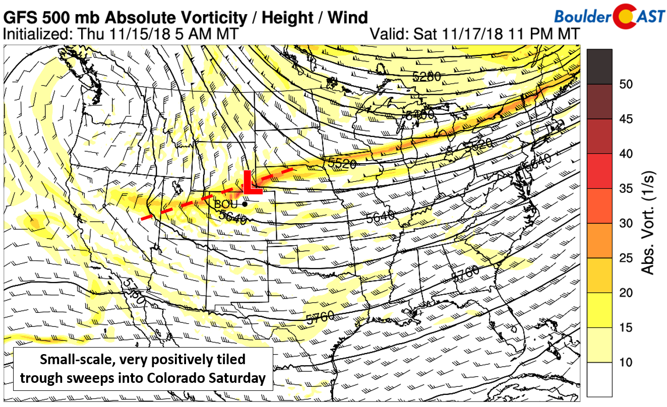
GFS 500 mb vorticity map for Saturday. The weak trough axis moves south across Colorado in evening.
Nonetheless, shallow low-level upslope will ensue as the front passes Friday night and it will stick around through all of Saturday. This will lead to cool and gloomy conditions across the Metro area, but not much in the way of snow initially. This storm is unique in that the cold front will preclude any snow 6 to 12 hours, if not longer. This is because the shallow upslope alone won’t be enough to generate ice crystals in the cloud layer. Early Saturday morning, model soundings (like the one below) are indicative of freezing mist or drizzle for the Front Range, especially for areas west of Interstate 25 and in the lower Foothills. Travel (yes, including walking) could become tricky as a result of light ice accumulations.
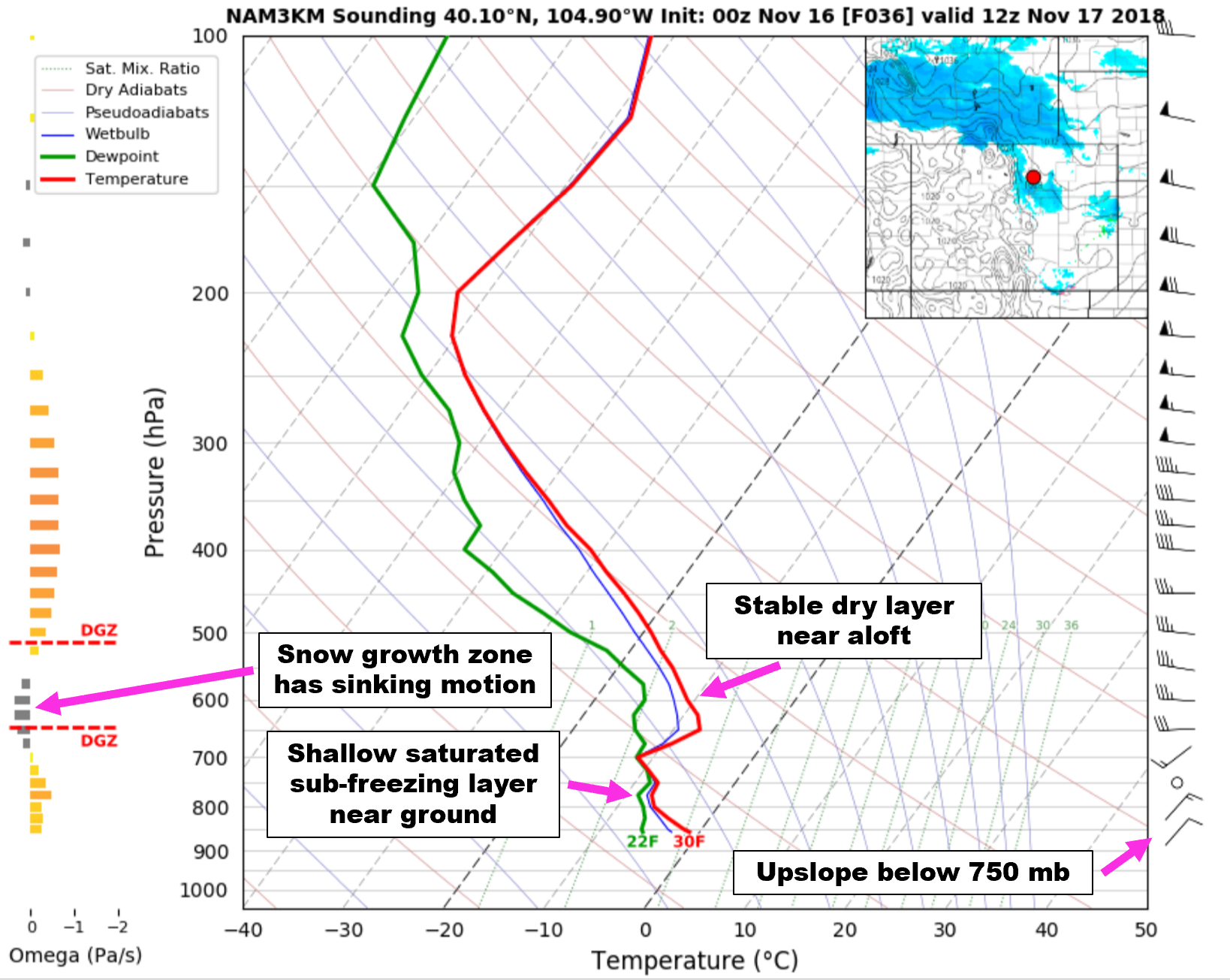
High-resolution NAM sounding for 5AM Saturday showing a classic freezing drizzle set-up in Boulder
It won’t be until the upper-level energy arrives Saturday late morning and afternoon that freezing drizzle will transition to snow showers from north to south across the Front Range. Lift from the trough and added instability from the overhead jet will be the necessary ingredients to make this change happen. Northern Colorado will be in the right entrance region of a weak jet streak from mid-day Saturday into the evening hours. Isolated banded snow will be possible during this time as a consequence.
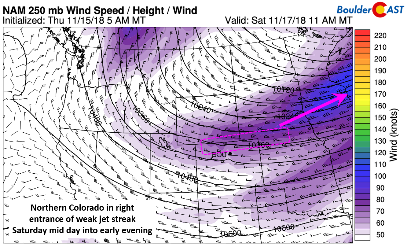
NAM 250 mb wind forecast for Saturday mid-day showing that northern Colorado will be in the right entrance region of a weak jet streak
The trough axis and jet energy will be weakening as they move into Colorado on Saturday, resulting in areas further north (such as Fort Collins & Boulder) seeing more accumulating snow than those down south (Denver & Aurora).
The shallow northeasterly upslope is forecast to be confined below 750 mb. Higher up in the atmosphere, west-southwesterly winds should enhance snowfall near and west of the Divide, particularly on the west-facing slopes from Boulder County northward. Thus, these Mountain areas could see several inches of snow. Spill-over from the Divide will be a good seeder-feeder mechanism for the higher Foothills in the northwestern Metro area. This will also allow for some decent snow totals near Ward, Allenspark, and Estes Park.
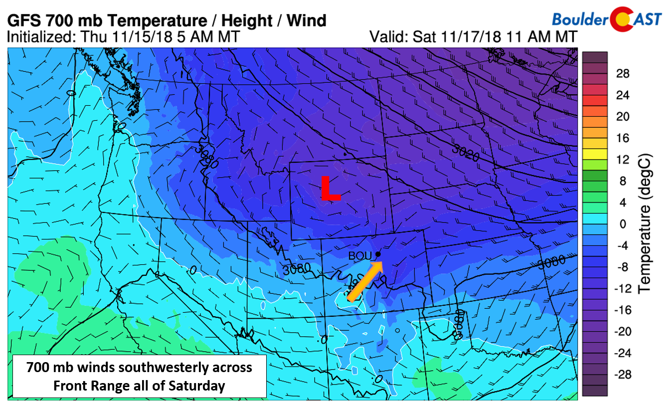
700 mb temperature and wind forecast for Saturday mid-day showing west and southwest flow in place across the Front Range.
Across the lower elevations, freezing mist and drizzle Saturday morning will change to snow through the day with some minor snow accumulations possible.
TIMELINE
- Friday will be pleasant, albeit a little breezy, with wave clouds filling the skies and temperatures reaching the lower 60’s.
- A cold front arrives around midnight Friday evening, with temperatures falling into the lower 30’s and low clouds forming as shallow upslope takes hold.
- Early Saturday morning the lower atmosphere will saturate producing patchy light freezing mist and drizzle as temperatures drop below freezing. Some minor ice accumulations will be possible west of Interstate 25 and up to around 7500 feet elevation.
- Freezing drizzle will transition to snow Saturday late morning into the afternoon, particularly north of Denver to the Wyoming border. Temperatures will remain in the 20’s through the day. Isolated banded snow showers will be possible in the afternoon and evening with snowfall rates of 1 to 1.5″ per hour.
- Light snow showers will continue into Saturday evening before fully tapering off after midnight Saturday night.
- Sunday will be very cold in the morning with lows in the teens, but should warm up nicely with sunny skies into the 40’s.
SNOW AMOUNTS
The GFS model is currently the most bullish with snow for the Metro Area, indicating 2 to 5″ in Boulder. The Euro, GFS-FV3 (next generation GFS), and the NAM models bring lighter amounts of 1 to 2″ at most.
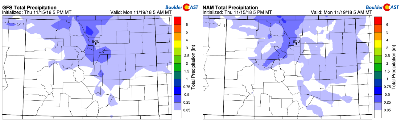
Total precipitation forecast from the GFS (left) and NAM (right) through Sunday
Overall, there isn’t a lot to like about this storm if you’re hopeful for much snow. The upslope is shallow, the jet max overhead is not that strong, moisture is limited aloft, the storm is quick moving, and the trough weakens considerably right as it gets upon our doorstep. We’re going to hedge a little lower than the GFS with a forecast of up to 3″ for the Metro area, with a likely bias north and west from Boulder into Fort Collins. The higher Foothills and Mountains, particularly in Larimer and Boulder Counties, could see 3 to 7″ or more by Sunday morning.
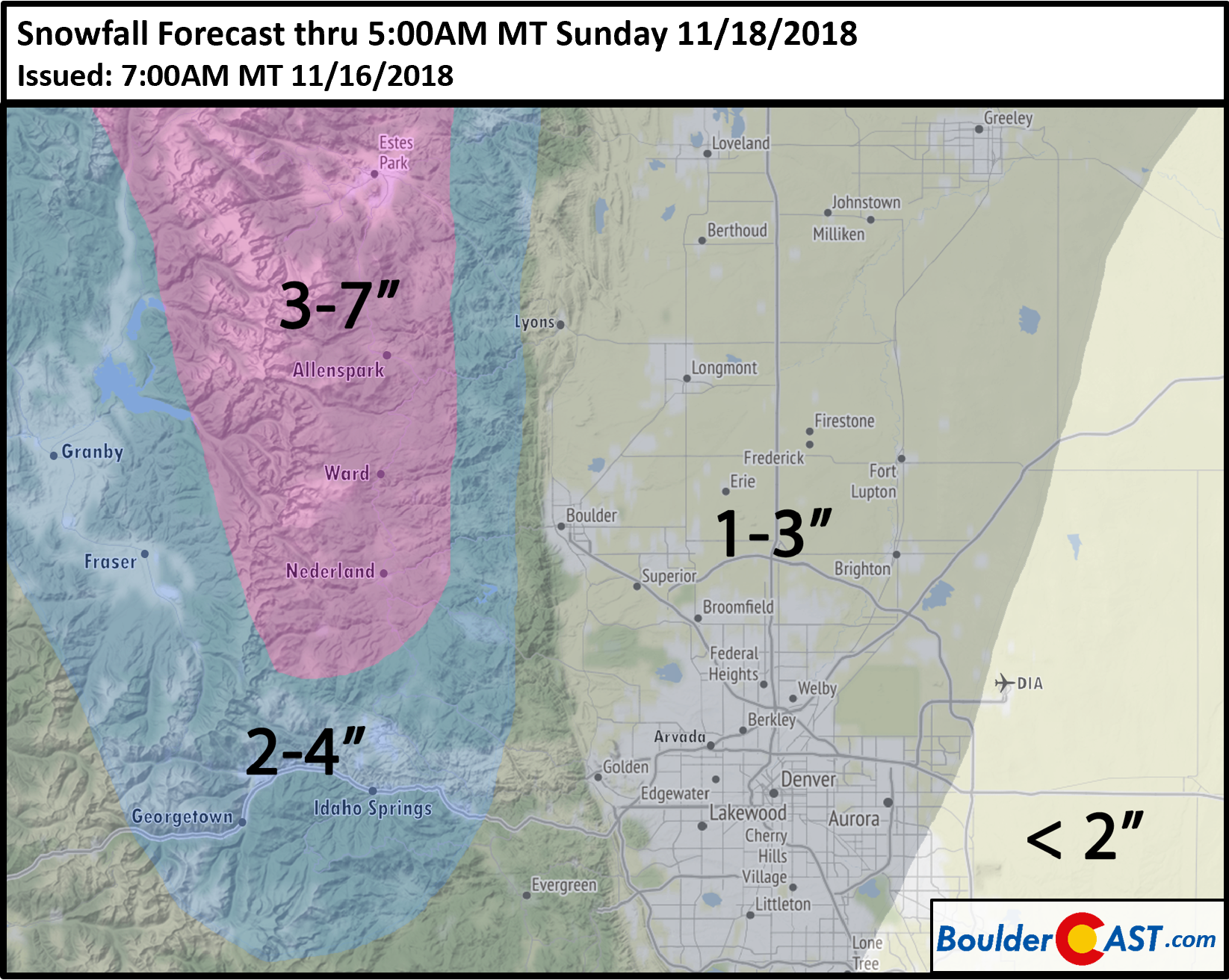
Our snowfall forecast map is shown below. There is still some uncertainty as to where the heavier jet-forced snow bands may form Saturday afternoon and evening, with localized areas that catch a band possibly seeing an inch or two more than our map shows. The most likely placement for any bands will be from Boulder to Fort Collins in our opinion.
Even without much snow, the threat of minor ice accumulations early Saturday could make for dangerous travel conditions across the Metro area. It really doesn’t take much ice in order to turn bridges and overpasses into a sheet of ice. We’re especially concerned about the areas from Arvada to Boulder to Lyons where freezing drizzle could setup for six to twelve hours. If you must travel on Saturday, do so with caution.
We’ve been discussing this threat of freezing drizzle accompanying the snow with our Premium members since Wednesday morning. Your fancy weather app didn’t catch it that early, did it?
¯\_(ツ)_/¯
Through Saturday November 17th, join BoulderCAST Premium (Yearly) and save 25% with promo code “ICY“.

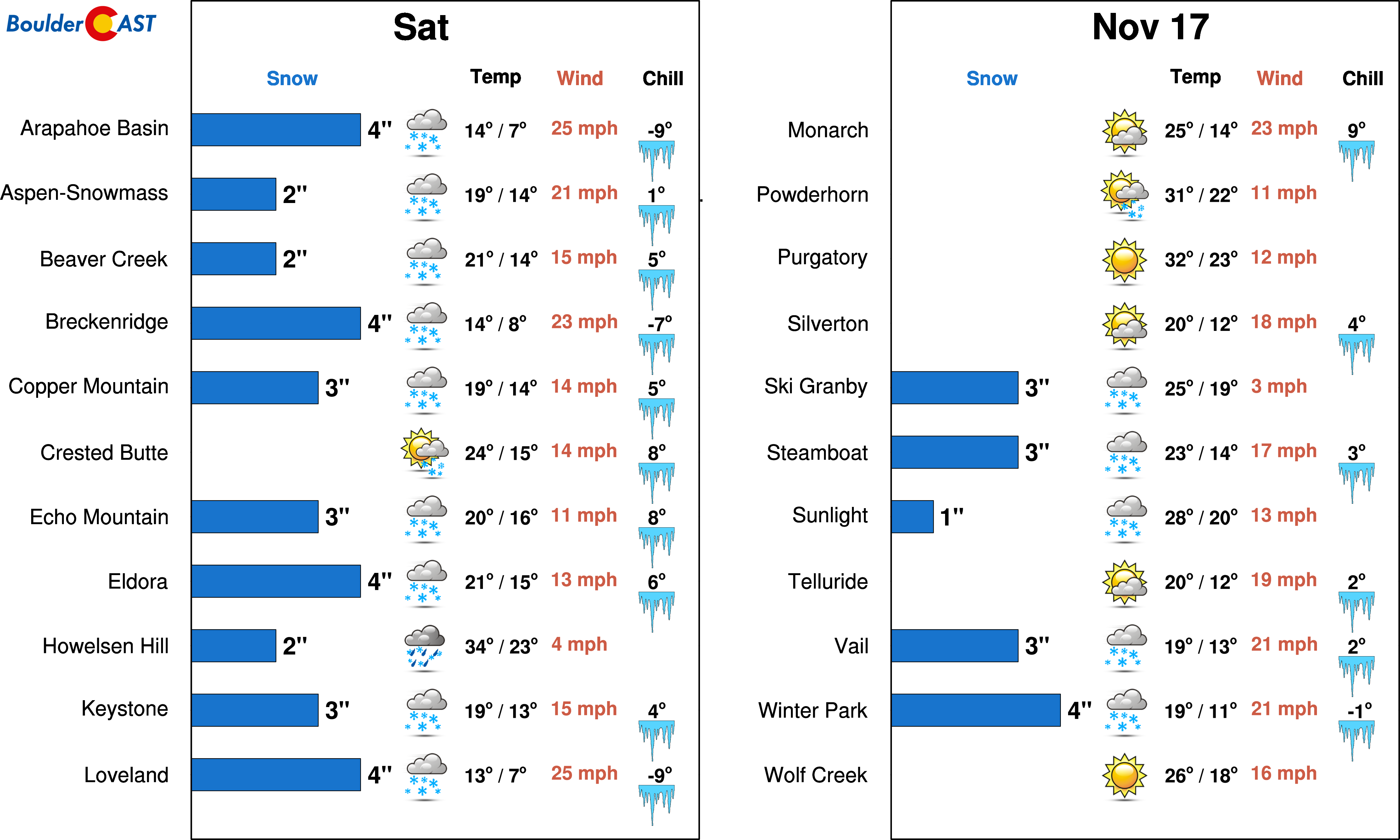
For those of you planning to hit the slopes this weekend, don’t expect much in the way of fresh powder from this storm. PowderCAST only predicts 1 to 4″ for the central and northern Colorado resorts.
One the back-side of the storm, we’ll see moderating temperatures and quieter conditions heading into Thanksgiving week as ridging moves into Colorado. Why is it winter seems to show up ONLY on the weekends?!…
Share this forecast:


You must be logged in to post a comment.