The weather pattern over the next few days is one that will be favorable for widespread and persistent precipitation across the Front Range. We’re even predicting temperatures to cool enough early Thursday to allow for a change-over to snow. Read on for a complete forecast on the prolonged, dreary weather expected in the coming days and our thoughts on preliminary snow amounts.
Help support our team of local meteorologists, get expert Front Range weather analysis from us every single day and access all our forecast content with BoulderCAST Premium.
Not unlike our last rain/snow event one week ago, the weather pattern at-hand this week is a complex one comprised of a co-mingling between a pair of shortwave disturbances. Does predicting the interplay between two distinct weather systems, compared to just a single storm, make for a trickier forecast? You bet! This is especially true this week as we have to consider abundant moisture, plenty of lift, favorable conditions for prolonged upslope, and potentially just enough cold air to turn rain over to snow. We’ll do our best, but do keep in mind that uncertainty is elevated, especially Thursday afternoon and beyond.
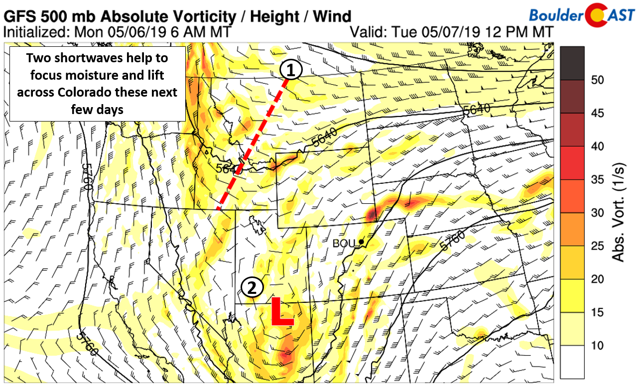
The mid-level vorticity map below lays out the two major players rather well. The primary system and one which will impact the region first is the cut-off low located in northern Arizona this morning. Energy and moist southerly flow ahead of this storm will move across Colorado through the day Tuesday leading to a good chance of showers and thunderstorms Tuesday afternoon and evening. Eventually on Wednesday this system will help to spawn a surface low across southeastern Colorado, intensifying upslope into the Front Range.
Meanwhile, a weak trough dipping out of western Canada is headed southeastward towards Colorado as of Tuesday morning. It won’t become a major player until early Wednesday when its cold front arrives to the Front Range (see below). This will help to inject colder air into the state which will eventually help turn the rain to snow across most of the Denver Metro area late Wednesday night into Thursday morning.
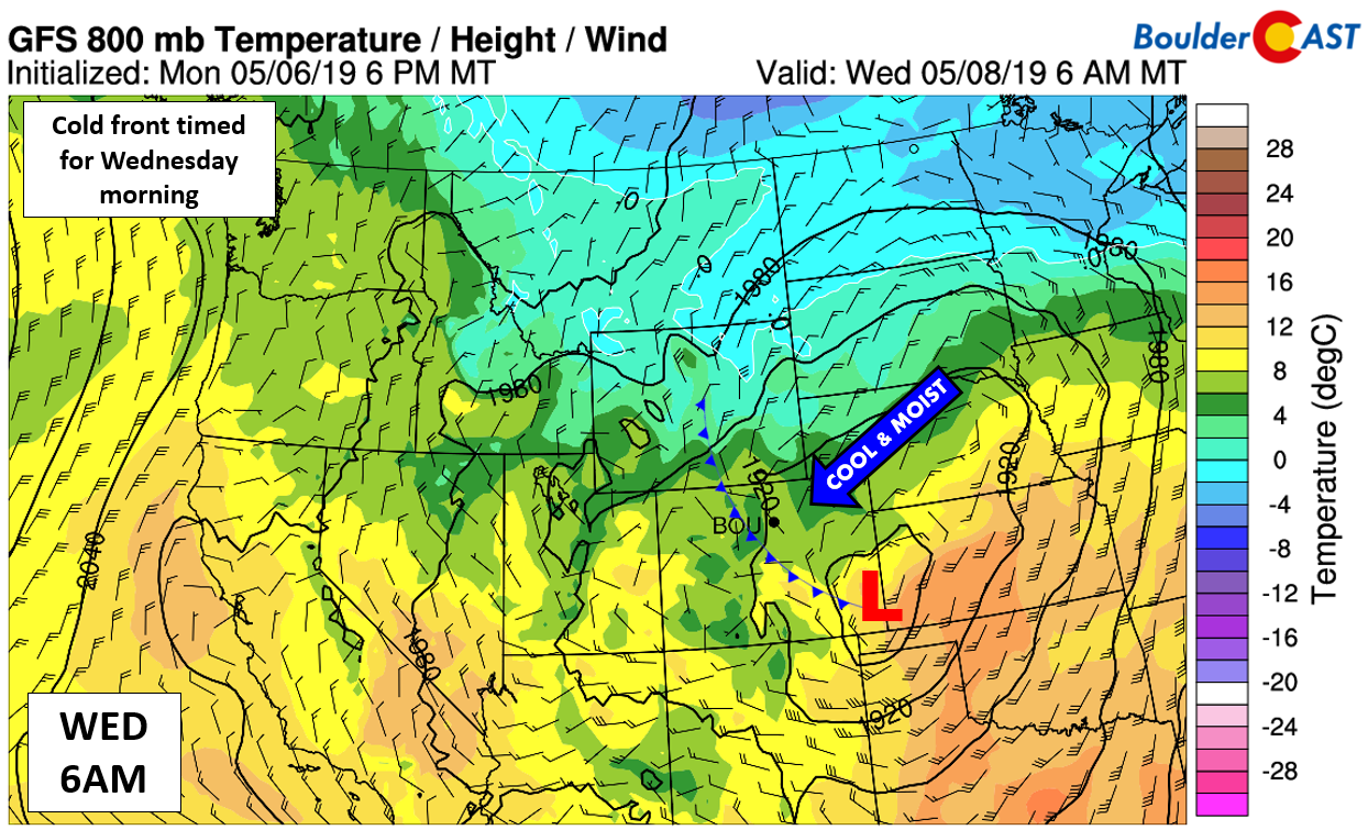
GFS 800 mb and temperature and wind forecast for Wednesday morning. A cold front will be moving into the Front Range
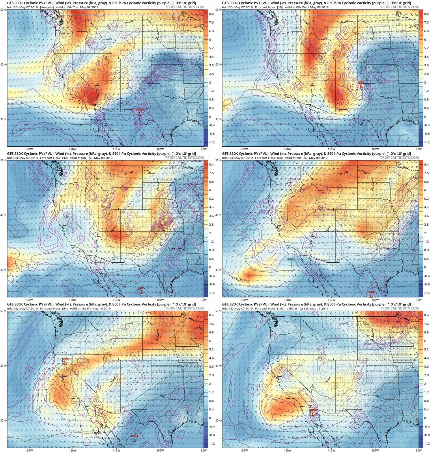
The animation below showing upper-atmospheric potential vorticity helps to visualize the fusion of the two shortwaves in the coming days. By the end of the animation, a piece of energy is shown to retrograde westward into southern California leaving relatively quiet conditions for Colorado late Friday into the weekend. This is potentially the “light at the end of the tunnel” with drying and nicer weather possible for the upcoming weekend. We have a lot of gloom to endure between now and then, though!
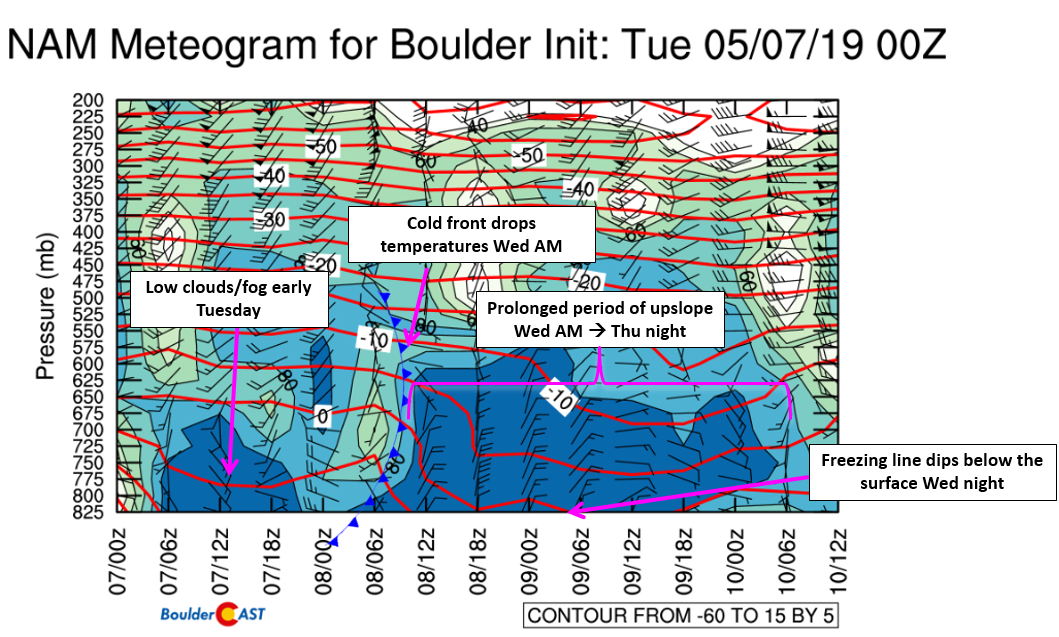
The most prominent factor influencing our weather now through Thursday will be moist low and mid-level upslope, especially following the passage of the cold front Wednesday morning. The graphic below is a forecast of temperature, winds, and relative humidity on a time-height plot for Boulder.
There are several key take-aways here:
- The blob of high relatively humidity Tuesday is the low clouds and drizzle resulting from moist southeasterly flow. This dissipates as the day wears on Tuesday, with drier westerly flow taking hold. This drying will lead to partial clearing and help to fuel the development of showers and storms Tuesday afternoon and evening across the area
- As the cold front passes Wednesday morning, the red temperature lines dip indicating cold air advection from the northeast. Highs Wednesday will be in the mid to upper 40’s with even colder temperatures on Thursday in the upper 30’s to lower 40’s
- Following the front, upslope is observed up to 600 mb all the way into Thursday night
- After midnight Wednesday night and early Thursday morning, temperatures drop very near to freezing at the surface. This is the time-frame we expect rain to change to a wet snow for most areas
Let’s first discuss potential precipitation amounts, then examine the possibility of snow. Precipitation amounts are likely to exceed 0.75″ for entire Metro area, with upslope-favored areas west of Interstate 25 able to push past 1″ of precipitation by Friday morning. The GFS and Euro models show anywhere from 1 to 2″ of liquid in Boulder. The NAM is lighter around 0.75 to 1.0″. Either way, this is great moisture that is sure to continue the Spring greening trend across the area!
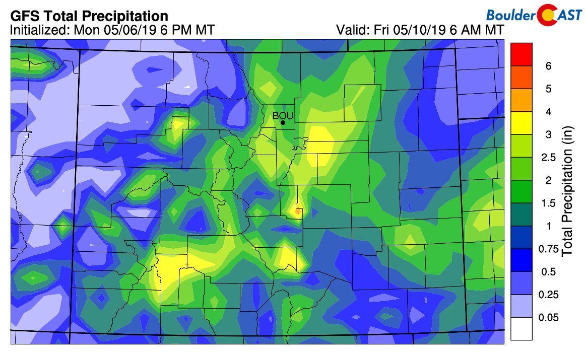
GFS total precipitation forecast through Friday morning. More than 1″ is possible across portions of the Front Range
An important note is that with the exception of Tuesday afternoon and evening’s convective storms, precipitation will be stratiform in nature Wednesday and Thursday. This means while it will be persistent, it won’t necessarily be that heavy. The long duration of the event is why precipitation amounts will ultimately become sizable. Widespread drizzle and showers are expected to last from Wednesday morning into Thursday evening. There may be some breaks in the action here and there, but areas in and near the Foothills, such as Boulder, will likely see nearly constant light precipitation during this period.
Outside of the fact that the next few days will be remarkably dreary by Colorado standards, we’re also tracking the rain turning to snow for the area late Wednesday night and early Thursday morning. It’s still not 100% set in stone, but chances are definitely looking good right now.
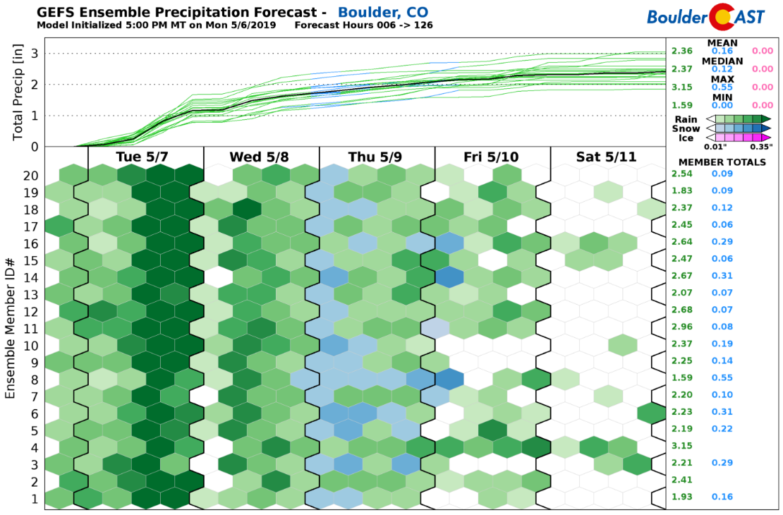
GFS ensemble precipitation forecast through Saturday. A very rainy (and maybe snowy) period lies ahead
In the last day or so, we’ve seen the global models turn colder overall, coming into better agreement with the regional models. Even still, temperatures are going to be very borderline for snow during this time. We’re predicting surface temperatures in Boulder and Denver dropping to around 32°F or 34°F after midnight Wednesday night. At the 700mb level (near 10000 feet elevation), temperatures are shown to cool to between -7°C and -9°C, which is usually cold enough for snow in Denver, but not always.
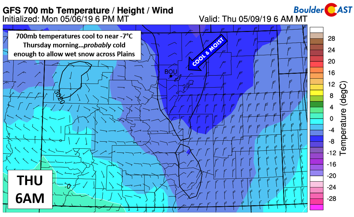
GFS 700 mb temperature and wind forecast for Thursday morning. Upslope and cold temperatures bring the chance of rain turning to snow.
Based on the latest run of the GFS model, our snow level algorithms predict a drop to near 6500 feet by midnight Wednesday night and then to below 5000 feet by sunrise Thursday. The NAM solutions are even colder than this, as is usually the case.
At this juncture, we’re seeing enough support to predict that just about everyone will see rain turn to snow Wednesday night with light accumulations possible. Areas below 5000 feet from Longmont to Greeley may remain just a chilly rain.
While it’s a little too early to pin-down exact snow amounts, mild ground temperatures will again be a hindrance. However, it appears that a decent wave of lift and upslope will be present during this time, so snowfall, if it does materialize, could be moderate at times across the area. The overnight and early morning timing will also benefit a little bit of snow sticking across the lower elevations. Here is our current thinking on snow amounts:
- Plains: 1 to 4″ with western suburbs seeing the most snow
- Foothills: 4 to 10″ above 8000 feet, 3 to 7″ between 6500 and 8000 feet
So yes, we’ll probably see some snow after midnight Wednesday night into Thursday morning. Will it be a major issue? Not really. But hey, snow in May is still significant in its own right. For 14 of the last 18 years, Boulder has reported measurable snow in the month of May. This is likely to become 15 of the last 19 years after this week.
Check back on Wednesday for our final thoughts on the snowy portion of the storm and our official snowfall forecast map. Until then, enjoy experiencing “Seattle weather” for just a few days. Colorado rarely offers up the opportunity!
5-Day Forecast:
Tuesday: Morning fog and drizzle, then mostly cloudy with scattered afternoon and evening thunderstorms. Some of these storms could produce small hail. Highs in the low to upper 50’s, dependent on the amount of clearing (if any).
Wednesday: Much cooler with overcast skies, showers, and drizzle through the day. As temperatures cool, light rain turns to snow late Wednesday night. Highs remain in the 40’s.
Thursday: Light snow showers hang around in the morning across the area with light accumulations possible. Spotty light rain/snow mix linger through much of the day, with some drying possible by late afternoon and evening. Highs in the upper 30’s to lower 40’s.
Friday: Clouds early with even a chance of rain/snow mix in the morning, then partly cloudy with highs in the 50’s.
Saturday: A mix of clouds and some sunshine. Likely dry with highs in the 60’s.
Help support our team of local meteorologists, get expert Front Range weather analysis from us every single day and access all our forecast content with BoulderCAST Premium.
Spread the word. Share our forecast:
.




You must be logged in to post a comment.