Ugly weather will linger across the Front Range through the Columbus Day holiday, including rain and what could be the first snow of the year for some cities. We detail the timing and forecast snowfall amounts for the region.
PREMIUM STORM UPDATE (Issued Mon Oct 8 at 7:00 AM): Checking in on our chances for snow. READ NOW
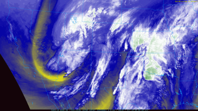
A potent Four Corners low and associated trough remain to our west this Sunday evening. The water-vapor animation above shows abundant moisture being brought northward into Colorado. The current position of the low pressure is shown below across southern Utah.

GFS 500 mb vorticity map for Monday morning
Though it was cloudy and cool through the day on Sunday, there wasn’t much precipitation across eastern Colorado as the best large-scale forcing remained to the west across the Mountains. This will soon change…We expect showers to increase significantly in both coverage and intensity through the night-time hours heading into early Monday.

HRRR simulated radar for 10PM Sunday evening. Showers will be on the increase across the Metro area.
Light to moderate precipitation will then be widespread across the Front Range through most of the Monday. Models agree that anywhere from 0.25″ to 0.75″ of liquid are on the table from this system. Great news as our entire region needs this moisture!
The big question then turns to will this precipitation be rain or snow?
Though the models haven’t done so great with the timing on the waves of precipitation associated with the broad trough, which we did expect , they have been steadfast on temperature. The coldest air won’t be arriving until later on Monday when the axis of the trough finally enters Colorado. It has previously been stalled-out across the Great Basin since Friday. The 700 mb temperature map below is for Monday night at midnight. Finally some decent cold air will be working into the state!

GFS 700mb temperature forecast for Monday evening. Colder air will be working into Colorado.
As is often the case with these early or late season storms, the push of cold air may be too late to turn rain to snow across the lower elevations. The GFS has snow levels beginning around 10000 feet this evening, falling to around 8500 feet by early Monday morning, then dropping further Monday through the day to encompass the Plains by evening. The Euro and NAM models are quite similar, however they come in a couple degrees colder in all cases. For this reason, we are trending our forecast a little snowier than than GFS.
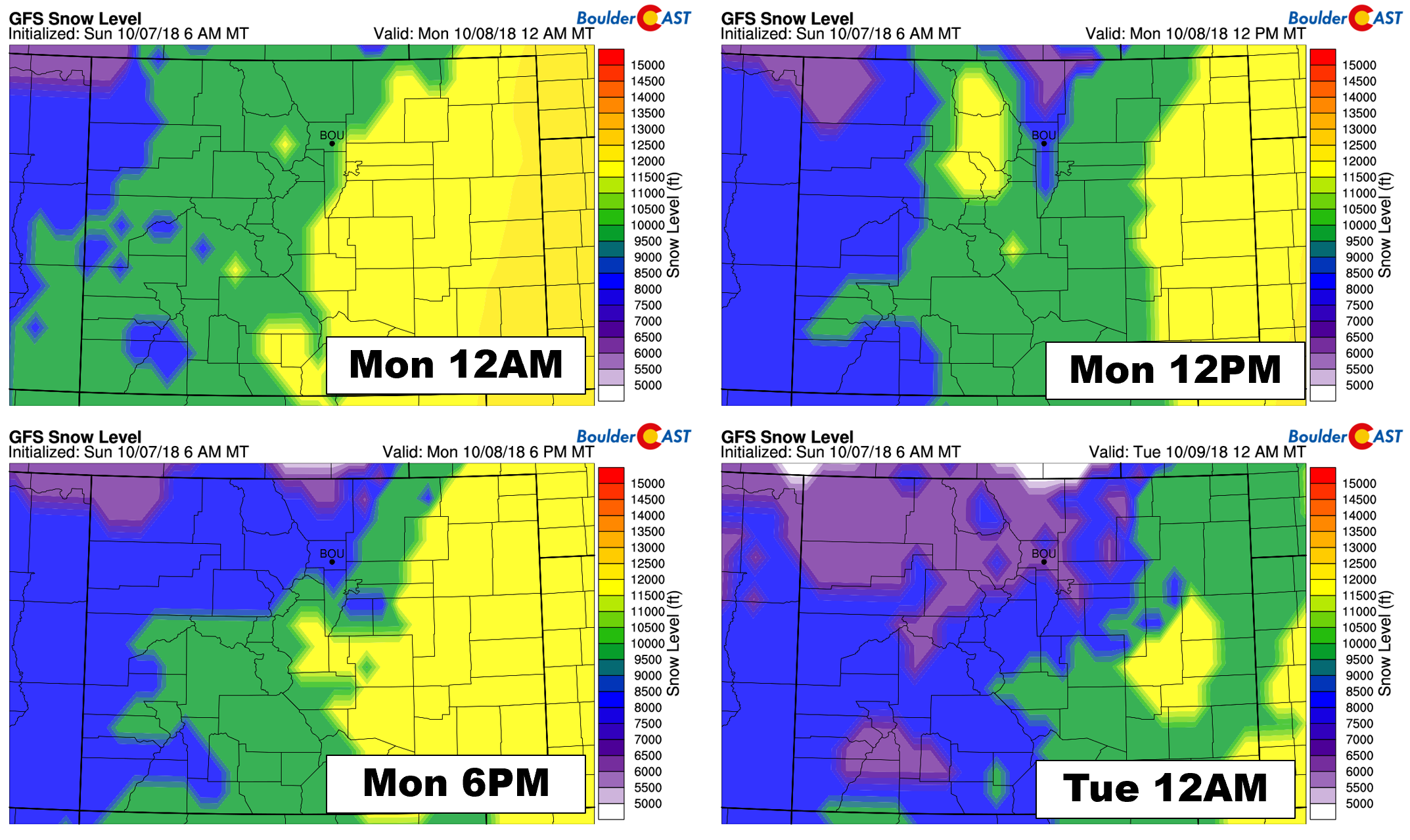
GFS snow level forecast for Sunday night into Monday night.
What this means is the showers Sunday night will be mainly snow for the higher Foothills above 9500 feet, with even some light snow accumulation possible by daybreak Monday all the way down to about 8000 feet. The Plains, including Boulder and Denver, will begin and remain all rain through late Monday morning. As colder air starts to work in through the day, snow levels will be dropping with wet snowflakes likely mixing in across the lower elevations. The storm will probably end as snow for everyone, but it will winding down quickly by early evening Monday. It’s conceivable that some areas across the Denver Metro could see 1 to 2″ of snow on grassy surfaces, especially if a heavier band or two passes overhead. Roads should remain only wet, though.
As big of a footprint as this storm has (i.e. the ENTIRE western United States), its bark will be much worse than its bite! The moisture is definitely there, but the dynamics are not aligning all that well for the Front Range. Upslope will be weak, disorganized, and not that deep. The time-height plot of wind below shows upslope will barely reach 700 mb, and if so, it will be southeasterly. This isn’t an ideal direction at all. Above this, a warmer, drier and more stable layer exists in the atmosphere. This elevated inversion will not be helping this either.
Near-ground level though, winds will be from the northeast. This should help keep the light precipitation going into Monday evening, especially near the base of the Foothills in Boulder.

GFS time-height plot of wind (barbs), temperature (red contours), and relative humidity (blue contours). The pink circle denotes the upslope for this event in Boulder.
All in all, this Columbus Day will be snowy or soggy, depending on your elevation. Though Denver saw its first official snowfall a few day ago, Boulder (and almost everywhere else) is still in the hunt…
Sunday night: Widespread showers developing late in the evening and continuing overnight. It will remain all rain on the lower elevations, but mostly snow will fall in the Foothills above 9000 feet, with a rain/snow mix for Foothills locations down to 8000 feet. Roads like Peak-to-Peak highway could become slushy in spots.
Monday: On-and-off drizzle and showers will continue through the day with cooler air filtering into the region and snow levels falling. Rain will change to snow through all of the Foothills, and eventually across the Plains by evening. Light accumulations are possible, mainly on grassy surfaces during the evening.
Monday night: Snow will wind down with just flurries remaining through part of the night. Clouds will likely stick around too, keeping us relatively “warm”, but some areas could dip below freezing for the first time this autumn.

Check PowderCAST for the ski forecast this week.
Tuesday & Beyond: General troughing isn’t going anywhere for us. Expect MUCH cooler than normal temperatures through the week (40’s and 50’s) with frost or a freeze nearly every morning.

Save 30% on BoulderCAST Premium through October 11, 2018
Join us before the first snow of the winter! Use the promo code SNOW at checkout to save 30% on an annual membership to BoulderCAST Premium. Offer ends October 11th.

.
Share our forecast!


You must be logged in to post a comment.