With little in the way of synoptic forcing, the monsoon will dominate our weather pattern this week, with a chance of storms each and every day. However, some days will be drier than others. Read on to find out which ones!
Despite very comfortable dew points in the 40s, a persistent deck of mid-level clouds has only allowed our temperature to drop into the mid 60s Monday morning. Colorado sits under the influence of an upper-level ridge, currently centered over the Lone Star State.
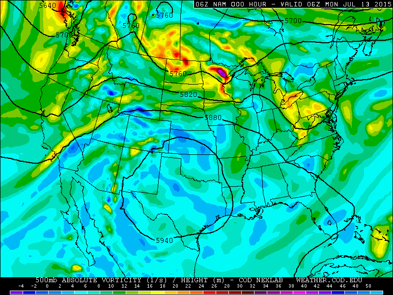
The 500mb vorticity map from the NAM model, valid at midnight Sunday evening, showing the location of an upper-level ridge over Texas.
After initially retrograding west towards Colorado, this ridge has been slowing drifting eastward for the last 24 hours. As a result, west-southwesterly flow has commenced, which will open the door for monsoon moisture to stream back into our region. The map below from the NAM model, depicting precipitable water vapor, shows a plume of monsoon moisture over southern Arizona. In typical monsoon fashion, southwesterly flow will bring this moisture into Colorado through the week.
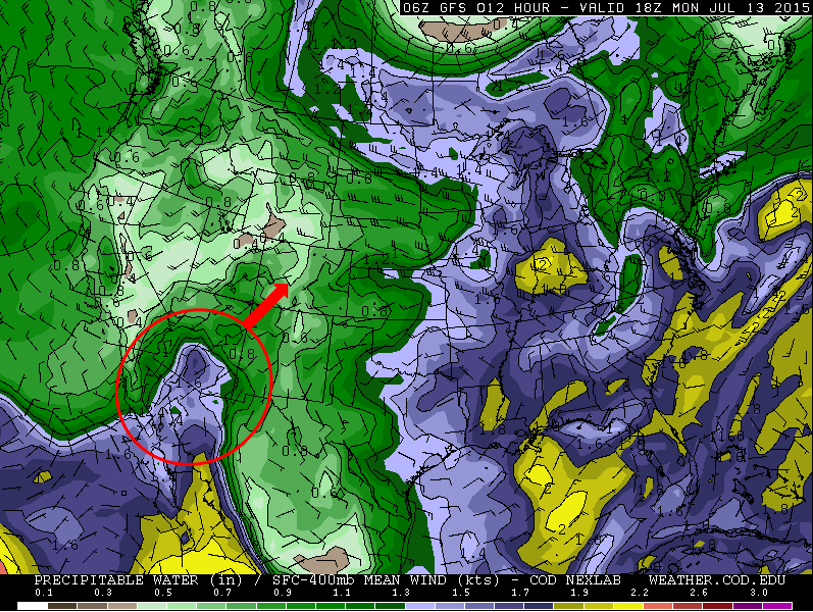
Precipitable water map from the GFS model, valid at noon Monday. Notice the large plume of moisture over southern Arizona. Southwesterly flow will advect this plume towards Colorado through the week.
On Monday, the moisture will not have fully built across Colorado, and cloud-cover will reduce the instability on the Plains. Expect isolated to scattered storms to develop over the mountains during the afternoon, with just a slight chance of storms on the Plains. High temperatures will be near seasonal normals, in the mid 80s, with 70s in the Foothills.
For Tuesday, both the GFS and NAM models indicate a subtle shortwave feature tracking across Colorado in the afternoon at the upper levels, and a weak surface cold front bringing some upslope to the region as well. The most favorable area for storm development will be south and east of Denver, but storm chances will be elevated for Boulder too, thanks in part to the upslope, particularly between 5pm and midnight. Expect scattered storms to develop over the high terrain, drifting northeast onto the Plains thereafter. Highs will be a few degrees cooler than Monday. There is a very slight risk of marginally-severe storms on Tuesday, with the far eastern portions of Boulder County (Longmont/Superior/Erie) having the greatest threat for hail around 1″ in diameter.
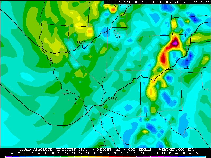
500mb height and vorticity map from the GFS model, valid at midnight Tuesday night. A piece of shortwave energy is tracking across Colorado that will enhance our storms Tuesday evening.
Wednesday through Friday appear to be plagued by hit or miss afternoon thunderstorms. There are no major synoptic forcing mechanisms, so the amount of moisture available on any given afternoon will determine the CAPE and extent of the resulting storm coverage. At this point, Wednesday and Friday look to have a better chance of storms across our region, with Thursday being slightly drier. However, storms cannot be fully ruled out on the Plains any day this week. In the Foothills and Mountains, scattered to numerous thunderstorms will fire with striking regularity each day. Temperatures will warm up by week’s end on the Plains, with Wednesday in the mid 80s, Thursday near 90, and Friday in the low 90s.
The Forecast:
Monday: Mostly cloudy with scattered afternoon storms in the high terrain. More stable conditions over the Plains will lead to just an isolated chance of a thunderstorm. High temperature in the mid 80s in the Plains, 70s in the Foothills.
Tuesday: Mostly cloudy with scattered to numerous storms developing in the mountains after noon. Scattered storms will drift northeast across the Plains. Heavy rain will be possible in the stronger, slower-moving cells. Hail approaching severe criteria (near 1.00″ in diameter) is possible (but not likely) in the evening across eastern Boulder County. Cooler with highs in the low to mid 80s on the Plains, with 70s on the Foothills.
Wednesday: Partly cloudy with scattered afternoon storms developing. Highs in the mid 80s on the Plains, with 70s in the Foothills.
Thursday: Mostly sunny with isolated afternoon storms. Highs near 90 degrees on the Plains, with low 80s in the Foothills.
Friday: Increasing clouds with isolated to scattered afternoon storms developing. Warmer with high temperatures in the low 90s on the Plains, with 80s in the Foothills.
Extended: Hurricane Dolores in the Eastern Pacific will be tracking northwest through the week. The potent southerly flow on the eastern side of this tropical system will enhance monsoon moisture in the Desert Southwest, and eventually Colorado. The first pulse of moisture, aided by Dolores, is projected to reach the Front Range late Sunday or Monday (July 19/20).
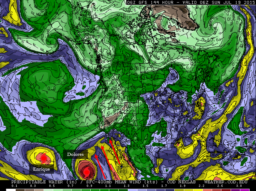
GFS precipitable water vapor map for North America, valid Saturday night at midnight, showing two tropical cyclones in the Eastern Pacific Ocean, as well as the plume of moisture being driven northward by Dolores.
Continuing from last week, below we have outlined our forecast high temperatures for the week ahead, as well as those from other major weather outlets.
Source
Mon
Tue
Wed
Thu
Fri


BoulderCAST
86
83
86
89
92


NWS
88
85
85
87
88


The Weather Channel
83
81
83
86
87


AccuWeather
86
85
85
89
93
Last week’s recap:
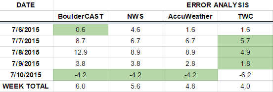
Mother Nature really made forecasters, including us at BoulderCAST, look silly last week. After a cold front passed on Sunday night, the models were miles off, indicating the cool, moist air mass would move out Tuesday AM. However, it ended up sticking around into Thursday. Here are the results of last week’s forecast. First, the forecasts and observations:
Now the error analysis. Shown is the amount of degrees (in Fahrenheit) that each source was off from the mean observed temperature for Boulder. Positive values indicate the forecast was warmer than what actually occurred, while negative values arise from a forecast that was cooler than what was observed.
Tuesday and Wednesday were particularly troublesome for meteorologists. After having the best forecast for Monday, BoulderCAST had the worst forecast for Tuesday, Wednesday, and Thursday. We did finish the week on top, tying for the closest forecast on Friday. Once we get through enough weeks, we’ll compile some data for your viewing pleasure! Stay tuned!
—
If you haven’t already done so, follow us on Twitter or Facebook for frequent weather updates and subscribe to the site to get these posts automatically delivered to your email box (enter your email in the sidebar widget to right).




You must be logged in to post a comment.