This week leans warm and deceptively calm across the Front Range, but there’s more going on under the hood than the mild afternoons suggest. A couple of brief cold fronts, a parade of passing shortwaves, and even a midweek fire‑weather setup all take turns shaping our pattern. Rain chances stay meager, frost may sneak in early Tuesday, and late‑week energy could stir up a few isolated showers. We break down what to expect—and what not to count on—in our latest weekly outlook.
This week’s highlights include:
🌡️ Warm week ahead: Daily highs run well above normal, with only two brief cold fronts offering short‑lived cooldowns.
🧊 Backdoor chill Monday night: An easterly surge brings gusts and a chilly overnight airmass, setting up patchy frost Tuesday morning.
🌬️ Midweek fire danger: Downslope winds, low humidity, and anomalous warmth on Wednesday could create a near-critical fire‑weather setup.
🌦️ Rain chances stay weak: A late‑week system may spark isolated showers, but ensemble totals remain only a few hundredths of an inch.
🌀 Passing disturbances: Several shortwaves skirt the region, influencing temps and winds but largely missing us with meaningful moisture.
DISCLAIMER: This weekly outlook forecast is created Monday morning and covers the entire upcoming week. Accuracy will decrease as the week progresses as this post is NOT updated. To receive daily updated forecasts from our team, among many other perks, subscribe to BoulderCAST Premium.

Go Premium, get all the perks.
Daily Forecast Updates
Get our daily forecast discussion every morning delivered to your inbox.
All Our Model Data
Access to all our Colorado-centric high-resolution weather model graphics. Seriously — every one!
Ski & Hiking Forecasts
6-day forecasts for all the Colorado ski resorts, plus more than 120 hiking trails, including every 14er.
Smoke Forecasts
Wildfire smoke concentration predictions up to 72 hours into the future.
Exclusive Content
Weekend outlooks every Thursday, bonus storm updates, historical data and much more!
No Advertisements
Enjoy ad-free viewing on the entire site.
A mild week with low-end isolated daytime showers
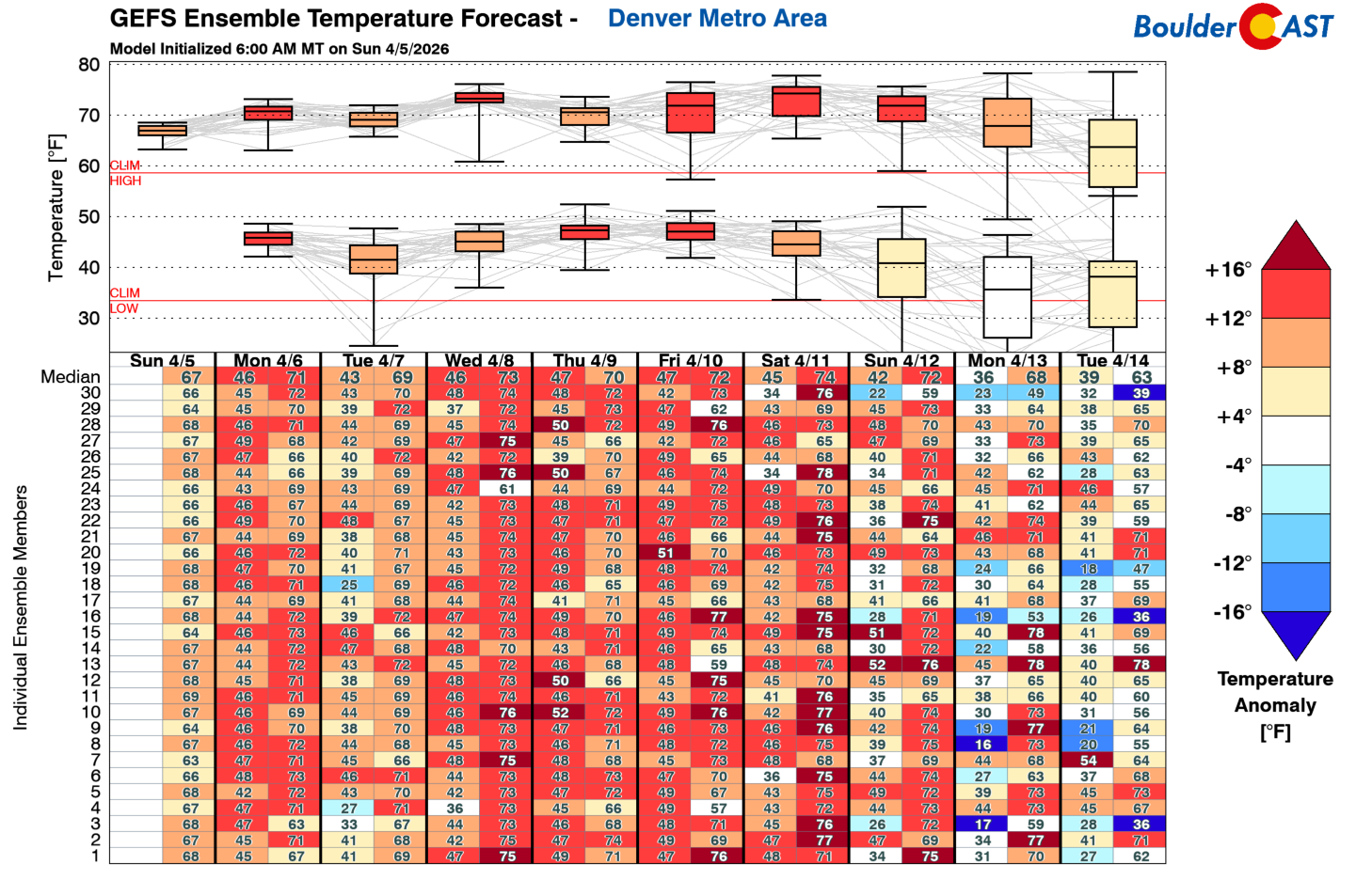
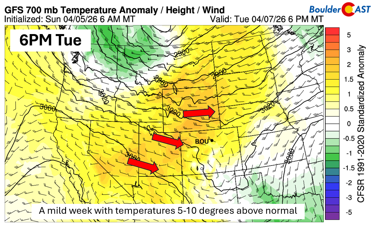
The upcoming week leans heavily warm for early April, with above‑normal temperatures showing up every single day. We are tracking a couple of cold fronts, but none of them look particularly tenacious. Each front briefly knocks temperatures back toward seasonal norms before the warmth rebounds. The GEFS temperature forecast below tells the story well: most afternoons this week cluster in the upper 60s to lower 70s, a solid 10–15°F above average for this time of year.
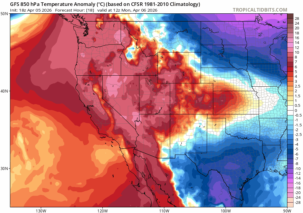
Low‑level temperature anomalies from the GFS (via tropicaltidbits.com) highlight the pattern even more clearly. Cooler anomalies slide into northeast Colorado and the Front Range tonight as a backdoor cold front pushes southwest out of the Plains. Another front midweek briefly nudges temperatures back toward normal. Outside of those two windows, the state is dominated by red and orange shading—broad, persistent warmth that will define the entire workweek.
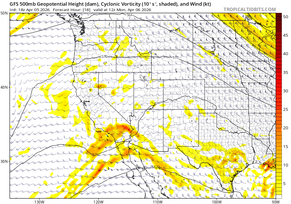
At mid‑levels, a parade of shortwaves will pass nearby but largely miss Colorado. The first disturbance today tracks across New Mexico, keeping its better lift and moisture south of the state. A second wave around Wednesday digs southeast from the Pacific Northwest into the Dakotas. This one matters for our fire‑weather concerns, but it shunts most of its moisture north of us, leaving the Front Range dry once again. A final late‑week system approaches from California and may toss just enough energy overhead Thursday and Friday to spark isolated afternoon showers.
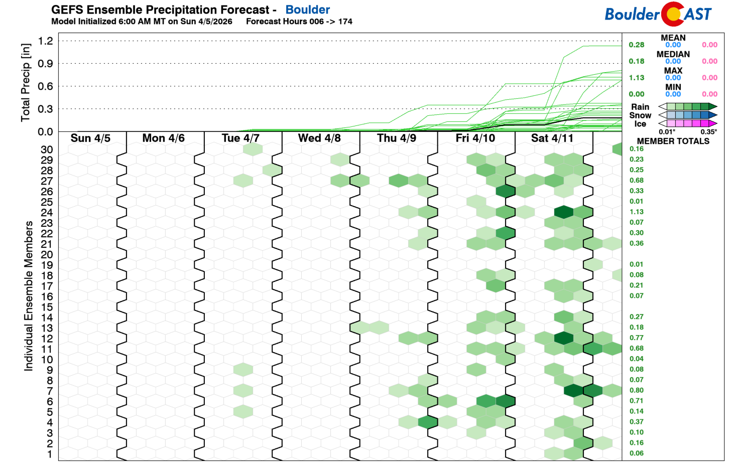
Rainfall prospects remain unimpressive. GEFS members continue to favor the best shot at instability‑driven showers late in the week—mainly Thursday and Friday—as the California system sends moisture and weak energy into the Four Corners. Even then, the signal is weak. Ensemble mean precipitation through Friday barely reaches a few hundredths of an inch. In other words, this pattern does not meaningfully dent our ongoing drought, and expectations should stay low.
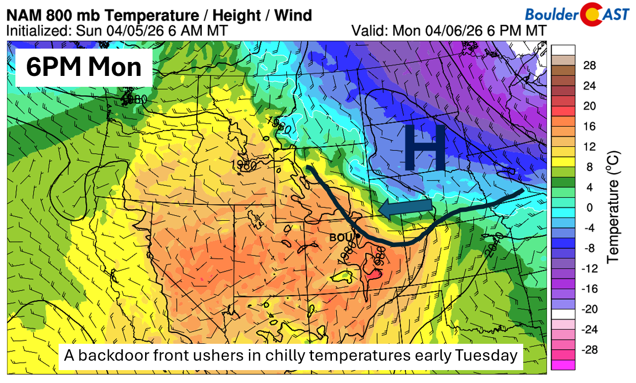
Back to that backdoor cold front: it slides into the Front Range Monday evening, shifting winds easterly with gusts of 20–25 MPH. Overnight, the airmass cools quickly and winds decouple, allowing temperatures to dip enough for patchy frost or even a light freeze by Tuesday morning. If you’ve jumped the gun on gardening or irrigation, covering tender plants Monday night and draining above ground pipes may be a wise move.
Fire concerns midweek
The warm anomalies this week naturally raise the question of fire danger, and Wednesday in particular stands out. The midweek shortwave dropping from Montana into the Dakotas will help crank up temperatures again, and the setup favors downslope flow along the Front Range.
Relative humidity values fall into the 15% range, and afternoon downslope gusts of 25–30 MPH appear likely. The strongest winds will be near the Wyoming–Colorado border, but the broader pattern supports at least a near-critical fire‑weather day for much of northern Colorado.
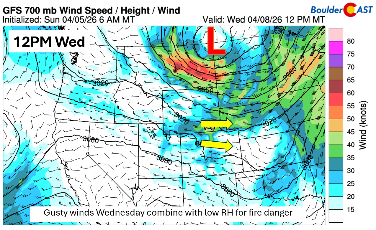
Some elevated fire danger may linger into Thursday, though humidity levels are expected to improve as the late‑week system approaches. Still, it’s a period worth monitoring closely—warmth, wind, and dry fuels remain a volatile combination this time of year.
Forecast Specifics:
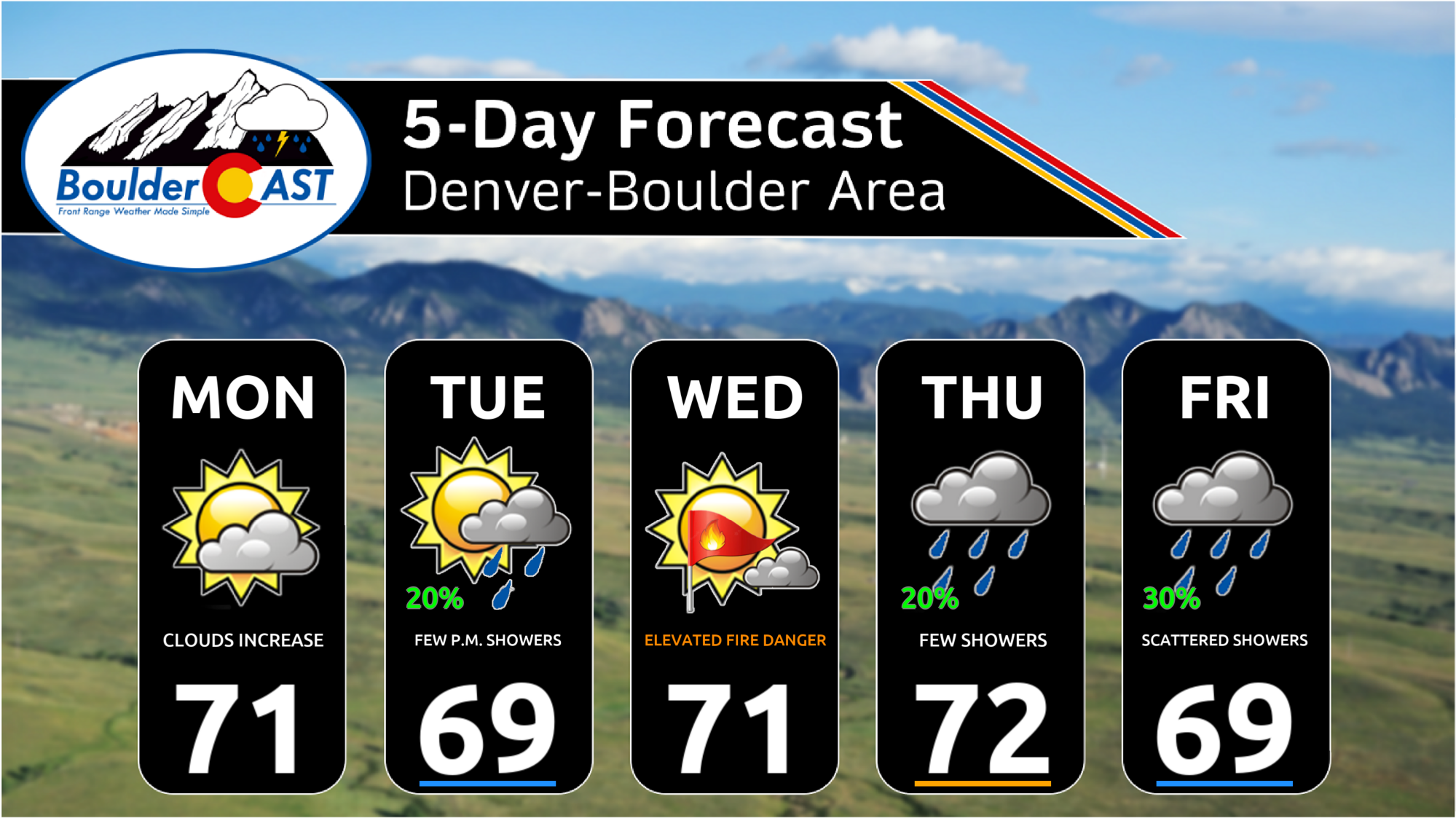
Monday through Friday: Highs hovering in the upper 60s to lower 70s each day, with upper 50s to low 60s in the Foothills.
Rain chances: Isolated afternoon and early evening instability showers are possible each day, but the best chance, at about 20-30% is Thursday and Friday. Rainfall amounts may only amount to a few hundredths of an inch through the week for most of us.
Weekend: Mild temperatures continue in the upper 60s to lower 70s, but unsettled weather may return with a better shot of afternoon or early evening isolated showers.
DISCLAIMER: This weekly outlook forecast is created Monday morning and covers the entire upcoming week. Accuracy will decrease as the week progresses as this post is NOT updated. To receive daily updated forecasts from our team, among many other perks, subscribe to BoulderCAST Premium.
Go Premium, get all the perks.
Daily Forecast Updates
Get our daily forecast discussion every morning delivered to your inbox.
All Our Model Data
Access to all our Colorado-centric high-resolution weather model graphics. Seriously — every one!
Ski & Hiking Forecasts
6-day forecasts for all the Colorado ski resorts, plus more than 120 hiking trails, including every 14er.
Smoke Forecasts
Wildfire smoke concentration predictions up to 72 hours into the future.
Exclusive Content
Weekend outlooks every Thursday, bonus storm updates, historical data and much more!
No Advertisements
Enjoy ad-free viewing on the entire site.
Enjoy our content? Give it a share!


You must be logged in to post a comment.