This week will feature a dynamic stretch of autumn weather in the Front Range including dramatic temperature swings, another influx of tropical moisture, and a midweek warm surge that could push us near 80°F. Following all of that, a late-week trough will bring a chilly front and our best shot at rain, plus there’s a weekend wildcard that might even produce some snow. Curious what’s driving all this weather? We break down the atmospheric setup, moisture sources, and ensemble model data in our latest weekly outlook.
This week’s highlights include:
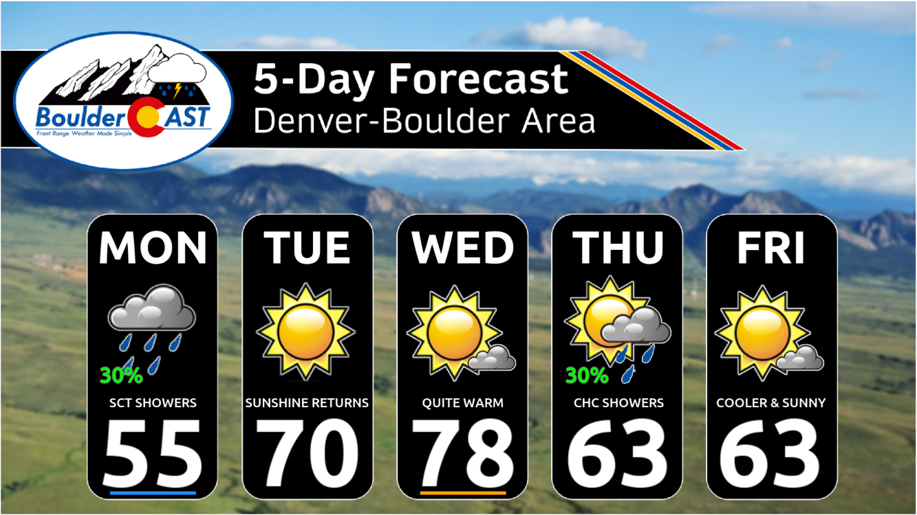
🎢 A Thermal Rollercoaster Ride: Monday stays chilly behind Sunday’s front, but a warm surge midweek could push highs near 80°F by Wednesday. Temps will tumble again late in the week.
🌧️ Tropical Moisture Returns: Deep tropical moisture from the remnants of Tropical Storm Raymond streams in Monday into Monday night, spreading precipitation mainly across the Mountains.
🌫️ Cloudy & Cool Monday: Expect overcast skies and spotty showers thanks to rich moisture overhead. Highs only in the 50s.
🔥 Wednesday Heat Spike: A warm airmass and southwest flow crank up temps midweek towards 80° — ideal for outdoor plans before the next cooldown.
🌡️ Late-Week Trough: A cold front Thursday will usher in a chance of rain, but downslope flow could limit coverage. Temps drop back to the 60s to end the week.
❄️ Weekend Snow Tease?: Ensemble models hint at the outside chance of light snow over the weekend if a deeper trough digs in from Canada — but that seems quite unlikely.
DISCLAIMER: This weekly outlook forecast is created Monday morning and covers the entire upcoming week. Accuracy will decrease as the week progresses as this post is NOT updated. To receive daily updated forecasts from our team, among many other perks, subscribe to BoulderCAST Premium.

Go Premium, get all the perks.
Daily Forecast Updates
Get our daily forecast discussion every morning delivered to your inbox.
All Our Model Data
Access to all our Colorado-centric high-resolution weather model graphics. Seriously — every one!
Ski & Hiking Forecasts
6-day forecasts for all the Colorado ski resorts, plus more than 120 hiking trails, including every 14er.
Smoke Forecasts
Wildfire smoke concentration predictions up to 72 hours into the future.
Exclusive Content
Weekend outlooks every Thursday, bonus storm updates, historical data and much more!
No Advertisements
Enjoy ad-free viewing on the entire site.
Temperature Swings Ahead
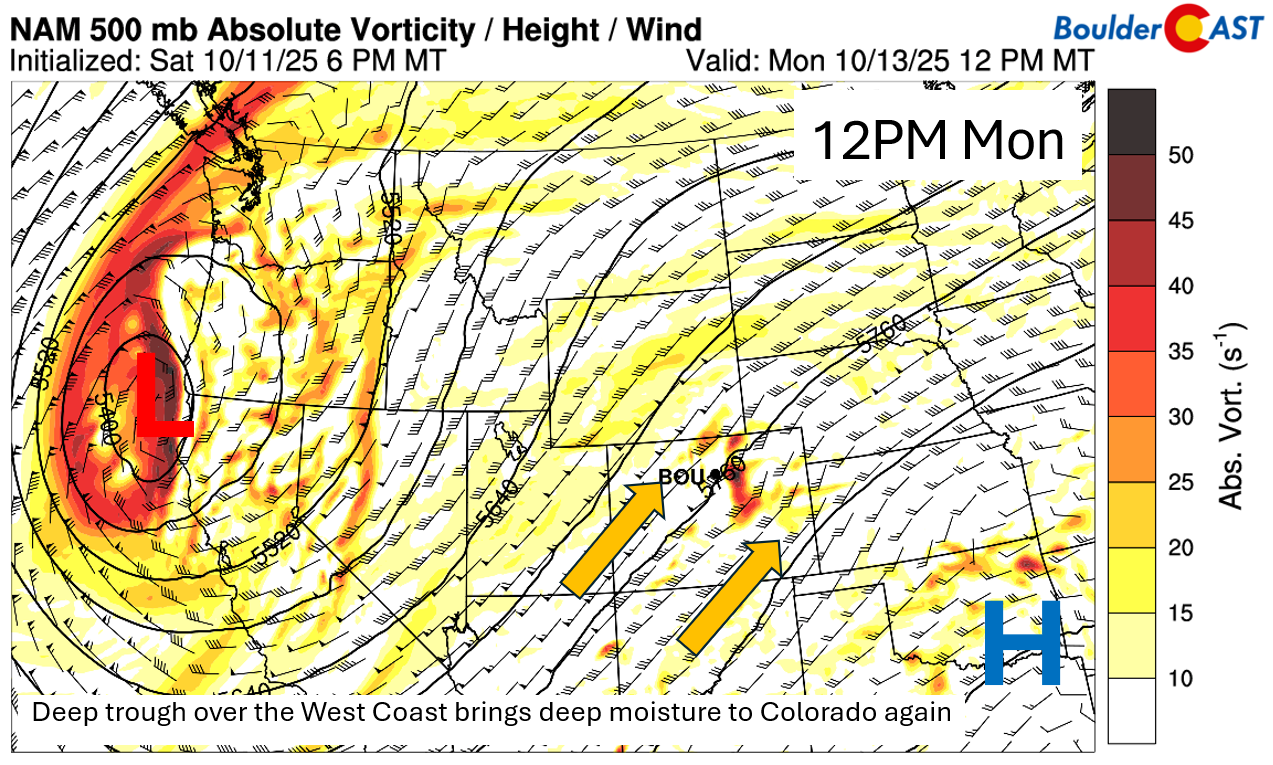
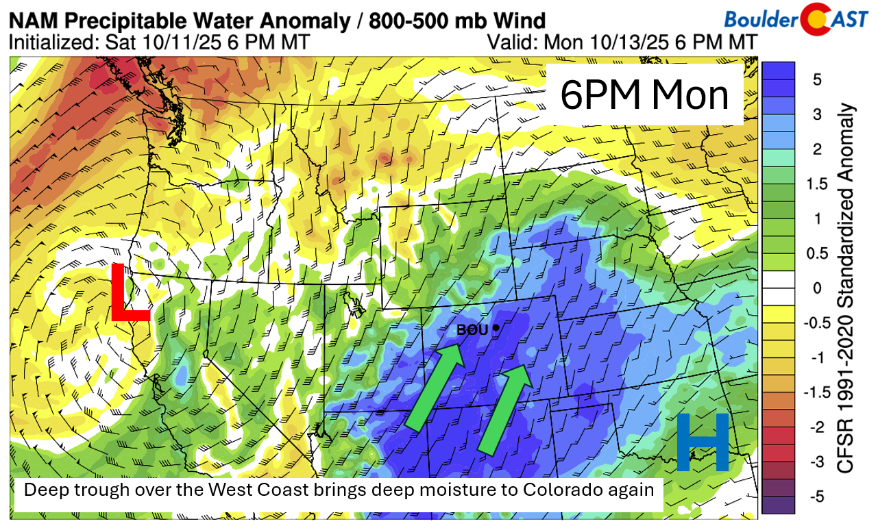
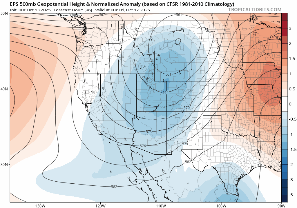
We’re kicking off the week with a bit of a thermal rollercoaster. Before we dive into the “why,” let’s set the stage: a strong upper-level trough is digging into the West Coast today, pushing into northern California tonight. Meanwhile, anomalous ridging is in place over the Southern Plains. Colorado? Smack dab in the middle — caught between these two systems with a robust southwest flow aloft to start the week.
But here at the surface, it’s a different story. We’re still under the influence of an easterly to northeasterly flow behind Sunday’s cold front. That’ll keep us cool and below average on Monday, with highs only in the 50s to lower 60s at best.
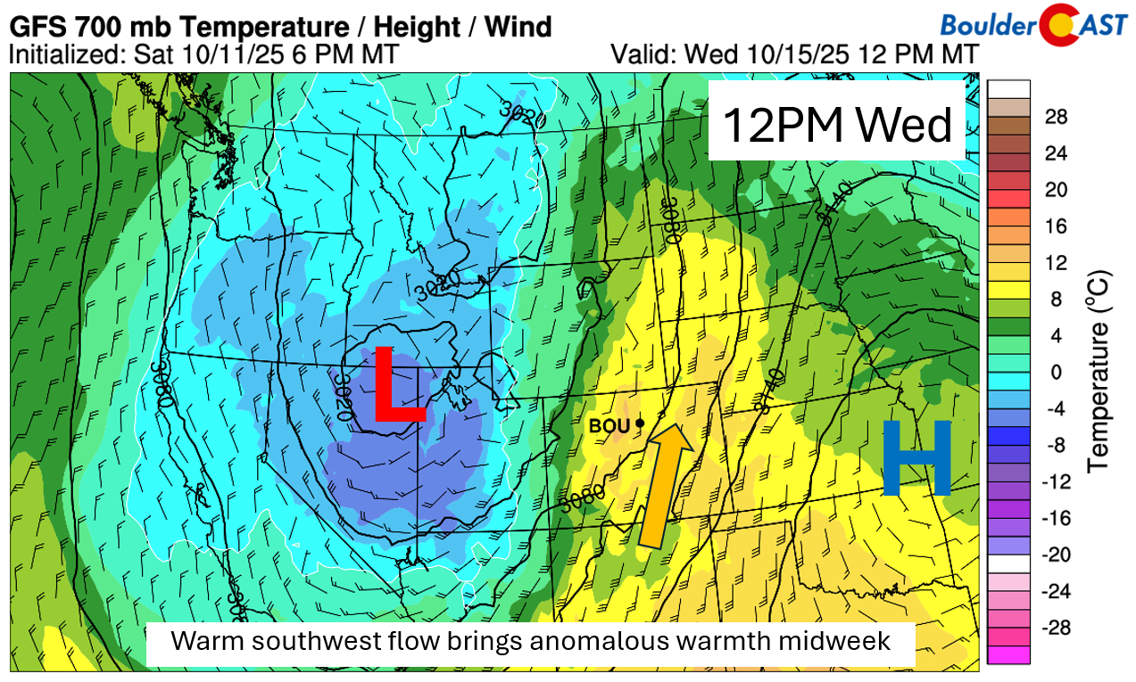
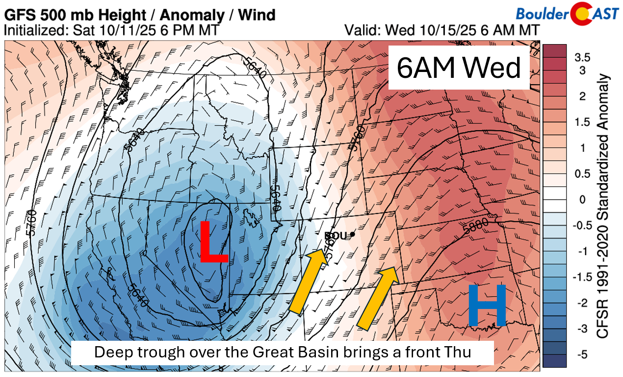
Starting Tuesday, we flip the switch. A warm front lifts northward, nudging us back toward seasonal highs near 70°F. By Wednesday, it’s like someone cranked up the thermostat — a very warm airmass surges in from the south as the trough shifts into the Great Basin. Expect highs in the upper 70s, and don’t be surprised if a few spots eclipse 80°F. Gusty winds may tag along too. If you’ve been waiting for a perfect day to sneak outside for a hike or tackle some yard work, Wednesday’s your golden ticket!
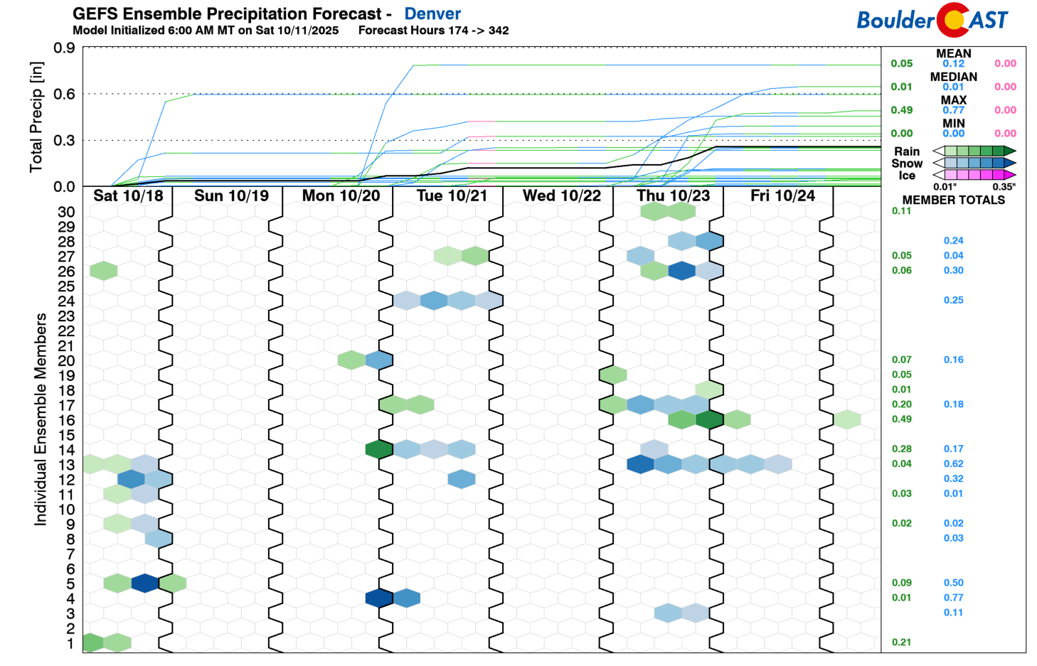
Southwest flow aloft early in the week will once again tap into deep moisture Monday into Tuesday, thanks to remnants of Tropical Storm Raymond, which fizzled over Baja California on Sunday.
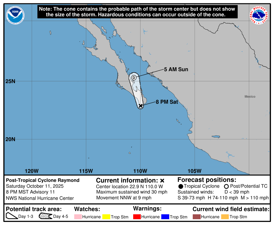
That moisture will stream northward, but unfortunately, the Boulder-Denver area will likely miss out on meaningful rain again. A few spotty showers may pop up Monday into Monday night, but most of us east of the Mountains will just see spotty light rainfall potential — though Monday will feel drab and gloomy with all that moisture overhead (after brief morning sunshine).
Late-Week Trough Brings Another Shot at Rain
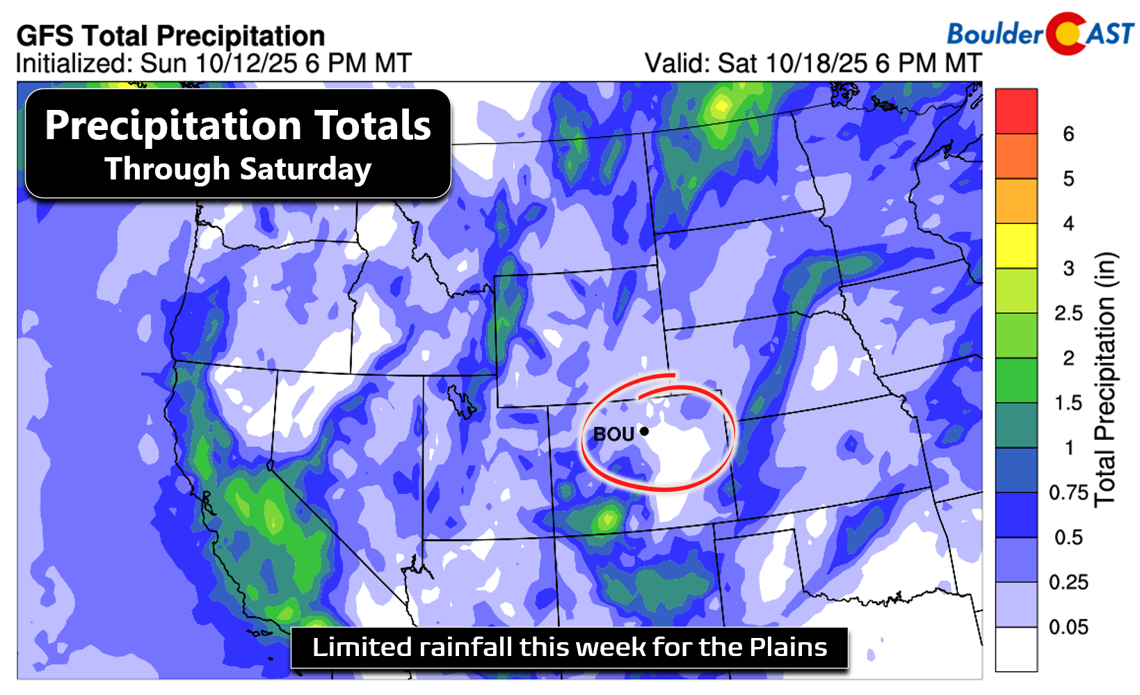
By Thursday, the West Coast trough pivots northeast into Wyoming and the Dakotas, dragging a cold front through the Front Range sometime Thursday afternoon or evening. This setup should offer our best shot at showers this week, but confidence is low. Downslope flow may limit available lift, keeping rain and snow chances modest. A stray storm or two can’t be ruled out — mainly over eastern Colorado and into Kansas. Expect another temperature dip, with highs back in the 60s Thursday and Friday.
Even with two rain chances this week (Monday and Thursday), overall accumulation looks minimal. The best shot at meaningful moisture will be over western and southwestern Colorado.
We warned you temperatures would fluctuate quite a bit this week — the proof is in the pudding:
Weekend snow chance?
Looking ahead to the weekend, things get murky. Ensemble models show a range of scenarios for Saturday into Sunday, hinging on how a broad trough over the northern Rockies evolves — and whether a secondary trough from Canada joins the party.
The images below show a set of ensemble cluster solutions (potential mid-level pattern scenarios) for Saturday into Sunday. Most of the potential solutions indicate another trough aiming to dig down from Canada and the northern Great Plains. Two of those clusters favor a deeper and more western trough over Colorado, while other scenarios keep the main trough to our north and east. If the more western and deeper solution were to verify, it could favor a quick-moving system to bring a low-end snow chance to the area. In fact, those solutions would also indicate a decent cold airmass with lows perhaps getting close to freezing by Sunday morning. We will have to see what solution wins out — too early to tell.
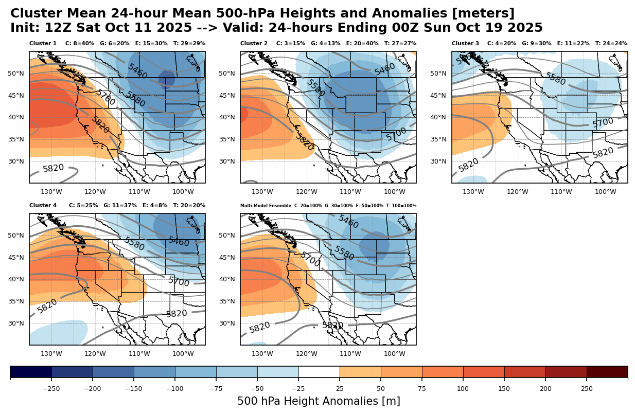
A few GEFS members do hint at snow Saturday, but most are dry. So while it’s not a high-confidence forecast, it’s worth keeping an eye on for the weekend — especially as we slide deeper into fall.
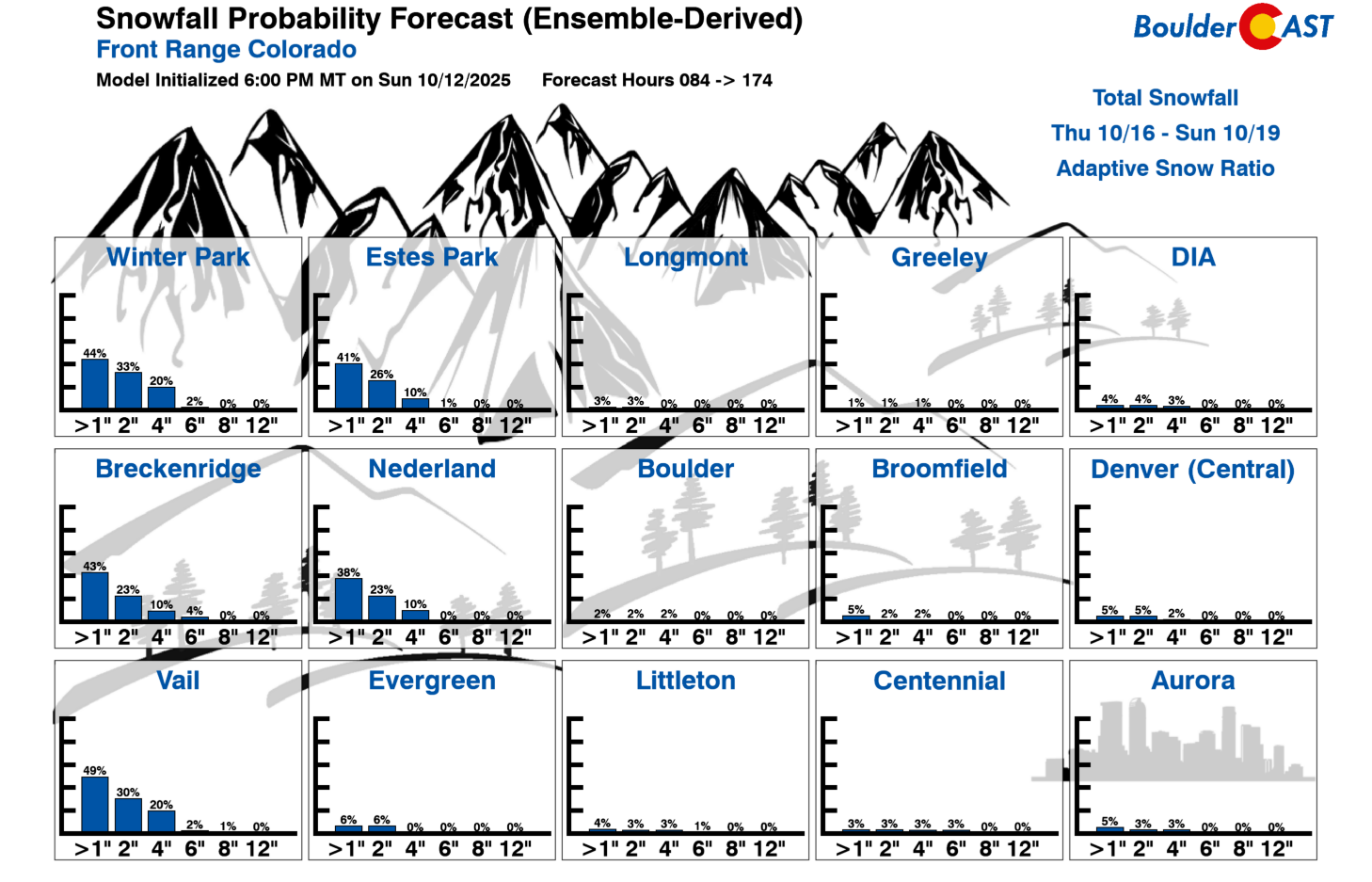
We must say: it’s definitely nice to see the first non-zero values appearing across the lower elevations in our Snowfall Probability Charts. It’s been far too long…
Forecast Specifics:
Monday: A brief period of morning sunshine, then mostly cloudy with highs cool in the 50s to lower 60s for the Plains and near 50 over the Foothills. There could be a few showers around during the day lingering into the overnight.
Tuesday: Warmer with sunny skies. Highs near 70 on the Plains and near 60 in the Foothills.
Wednesday: Our warmest day of the week under mostly sunny skies. Highs approach 80 degrees for the Plains and upper 60s in the Foothills.
Thursday: A chance of showers during the afternoon and evening. Highs cooler under increasing clouds in the low to mid 60s for the Plains and middle 50s in the Foothills.
Friday: Partly to mostly sunny and slightly below average with low to mid 60s for the Plains and lower 50s in the Foothills. It could be breezy with west or northwest downslope winds.
Weekend: Temperatures are forecast to remain near or slightly below average with highs staying in the 60s, but a cold trend is possible by Sunday with lows nearing dipping towards freezing late in the weekend.
DISCLAIMER: This weekly outlook forecast is created Monday morning and covers the entire upcoming week. Accuracy will decrease as the week progresses as this post is NOT updated. To receive daily updated forecasts from our team, among many other perks, subscribe to BoulderCAST Premium.
Go Premium, get all the perks.
Daily Forecast Updates
Get our daily forecast discussion every morning delivered to your inbox.
All Our Model Data
Access to all our Colorado-centric high-resolution weather model graphics. Seriously — every one!
Ski & Hiking Forecasts
6-day forecasts for all the Colorado ski resorts, plus more than 120 hiking trails, including every 14er.
Smoke Forecasts
Wildfire smoke concentration predictions up to 72 hours into the future.
Exclusive Content
Weekend outlooks every Thursday, bonus storm updates, historical data and much more!
No Advertisements
Enjoy ad-free viewing on the entire site.
Enjoy our content? Give it a share!


You must be logged in to post a comment.