2025 has been exceptionally cold and snowy in the Front Range so far, but is that finally about to change? This week we can expect several tranquil sunny days to begin but we are watching the threat for more snow as a low-pressure system approaches from California by Thursday.
This week’s highlights include:
- Cold and Snowy Start to 2025: January has been colder and snowier than usual in eastern Colorado, with temperatures 6 to 10 degrees below normal with some areas seeing double their normal snowfall month-to-date
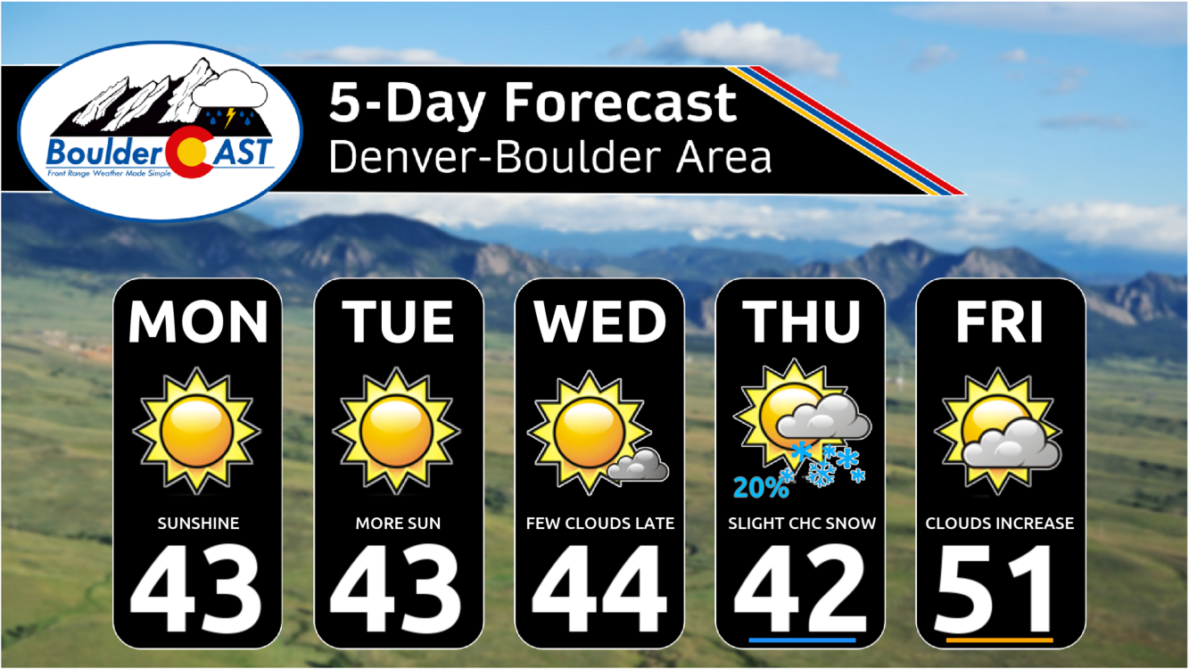
- Tranquil Start to the Week: The weather will be calm and sunny through Wednesday, with highs in the 40s in the Metro area and the 30s in the Foothills.
- Late-Week Snow Threat, Mainly South: A low-pressure system from California may bring a chance of light snow to the Front Range on Thursday, but the most likely outcome is for minimal impacts.
- Warmer End to the Week: After the low-pressure system passes, a ridge of high pressure will lead to warmer temperatures, with highs reaching the 50s by Friday and continuing through the weekend.
DISCLAIMER: This weekly outlook forecast is created Monday morning and covers the entire upcoming week. Accuracy will decrease as the week progresses as this post is NOT updated. To receive daily updated forecasts from our team, among many other perks, subscribe to BoulderCAST Premium.

Go Premium, get all the perks.
Daily Forecast Updates
Get our daily forecast discussion every morning delivered to your inbox.
All Our Model Data
Access to all our Colorado-centric high-resolution weather model graphics. Seriously — every one!
Ski & Hiking Forecasts
6-day forecasts for all the Colorado ski resorts, plus more than 120 hiking trails, including every 14er.
Smoke Forecasts
Wildfire smoke concentration predictions up to 72 hours into the future.
Exclusive Content
Weekend outlooks every Thursday, bonus storm updates, historical data and much more!
No Advertisements
Enjoy ad-free viewing on the entire site.
A cold & snow January thus far
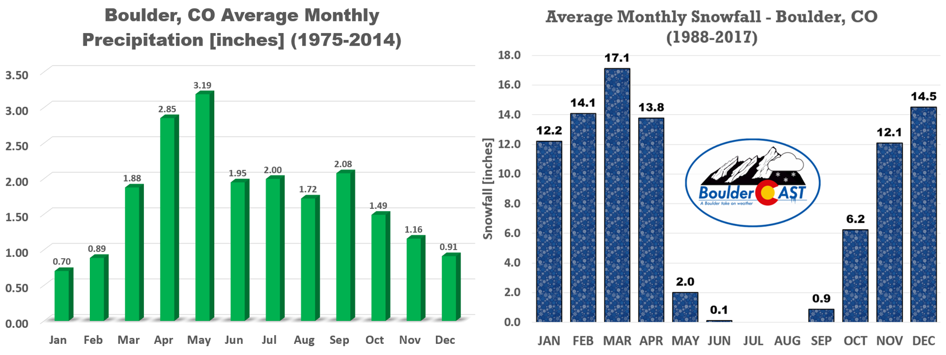
January is climatologically our second coldest but driest month of the year which is no surprise as the coldest air is also often the most devoid of moisture. Boulder only averages around 0.70″ of precipitation during the month, less than a quarter of what falls during our wettest springtime months.
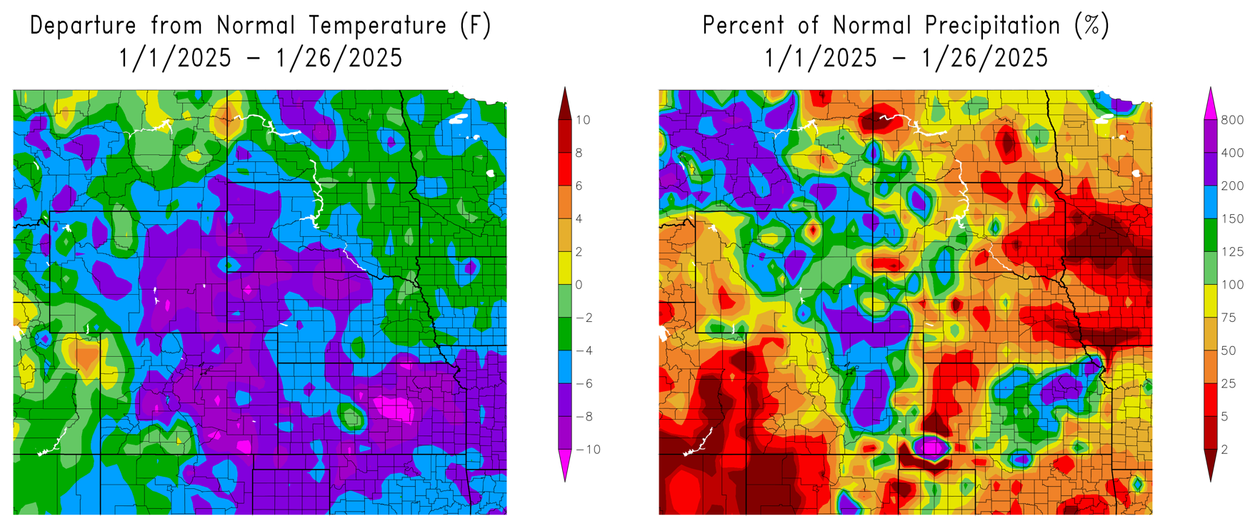
This January has definitely checked that “cold” box, with all of eastern Colorado seeing mean temperatures 6 to 10 degrees below normal month-to-date. On the contrary, the start of 2025 has turned out to be a very snowy one in the Front Range, with many of us seeing double our normal precipitation since ringing in the New Year.
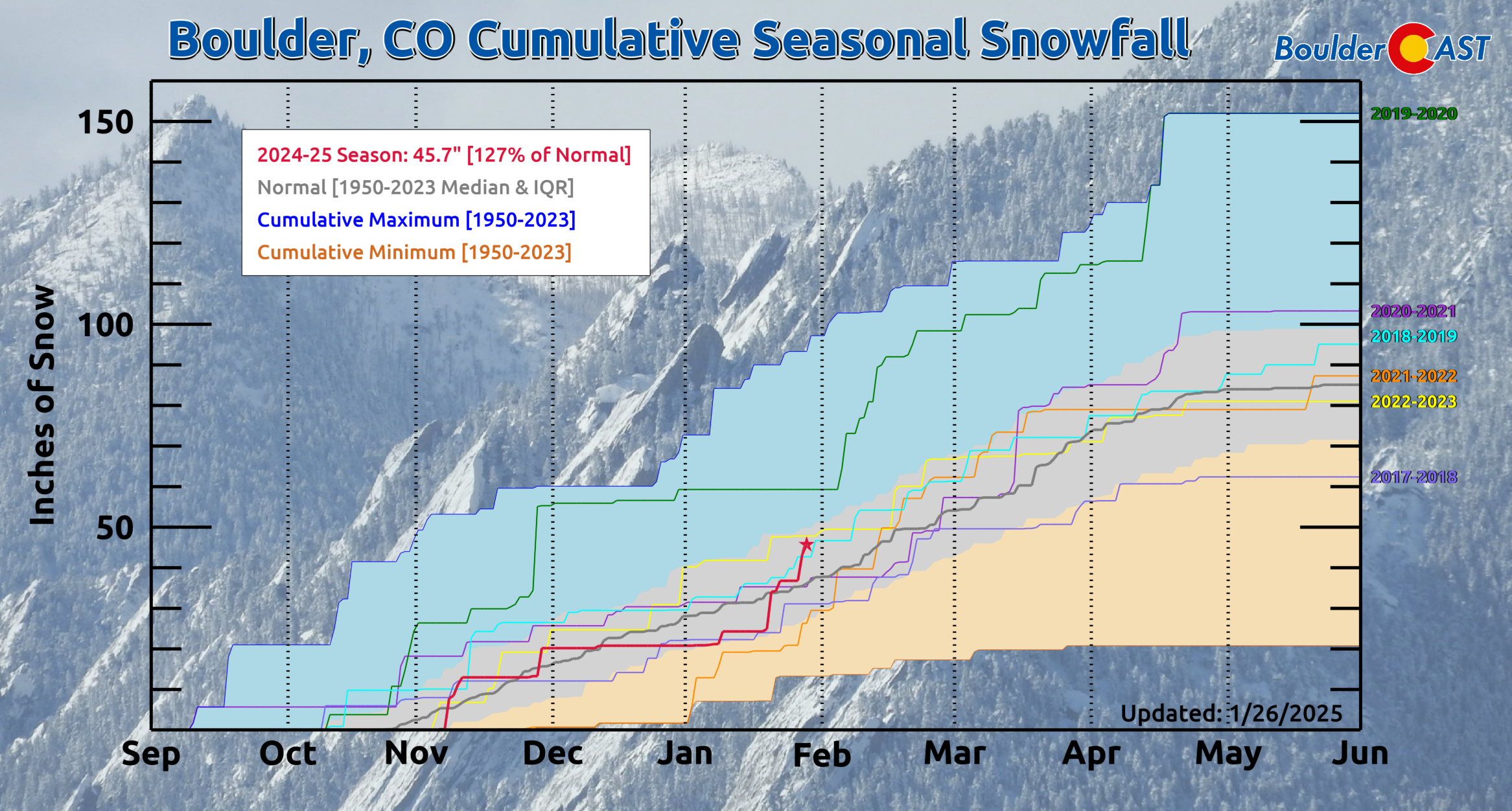
Here in Boulder, we’ve had 45.7″ of snow so far this season, with 24.9″ of that coming since January 1st. This has been the 6th snowiest January since 1950 for the city (with several days still left in the month mind you). Our seasonal snowfall total is 27% above the long-term median.
Will this cold and snowy trend continue for the week ahead? Read on to find out…
Tranquil through Wednesday between weather systems
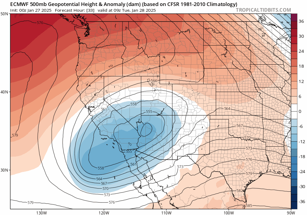
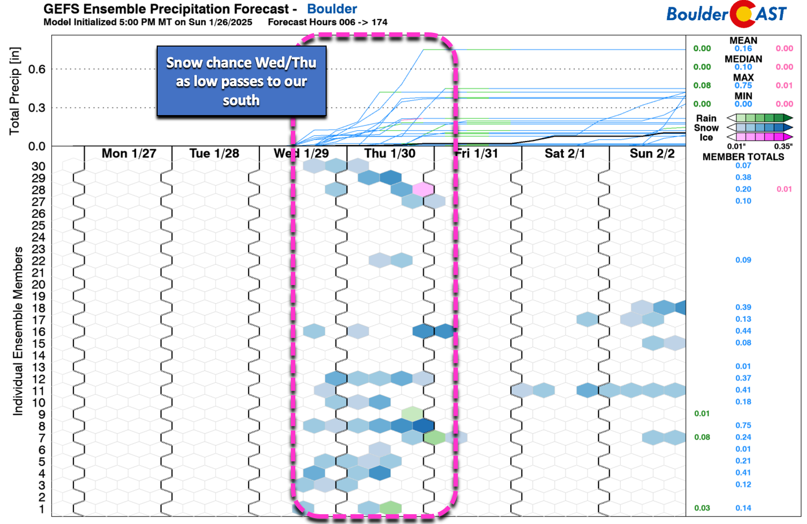
For those of you somehow getting tired of the endless winter wonderland we’ve found ourselves in lately, this week’s forecast will come as good news to you — well three days of good news, that is! The European ensemble 500mb height anomaly forecast animation below shows the situation in the mid-levels of the atmosphere through Thursday night. Notice that we’re in a stagnant pattern right now, with things really not changing much over the next 72 hours. The weak trough that brought us the snow over the weekend has shifted east, while a stalled closed-low pressure wanders about in California. Colorado will rest in between these two storm systems early in the week under mild westerly flow and shortwave ridging. That California low will eventually shift east later this week possibly introducing a chance of snow here on Thursday. More on this late-week snow threat in a moment.

For now, the next three days will be rather boring, with weak downslope flow keeping things quiet and sunny in the Front Range. Highs Monday through Wednesday will be in the 40s. As usual post-snow, there will be some colder and warmer spots, with high temperatures early this week anti-correlated with regional snow depth. That is, the areas that received the most snow recently will be coldest (upper 30s), with the least snowy areas warming up closer to 50 degrees through Wednesday.

California low passes to our south late-week
Throughout the week the big California low pressure will slowly trek eastward across the Desert Southwest, eventually sliding across New Mexico by Thursday.
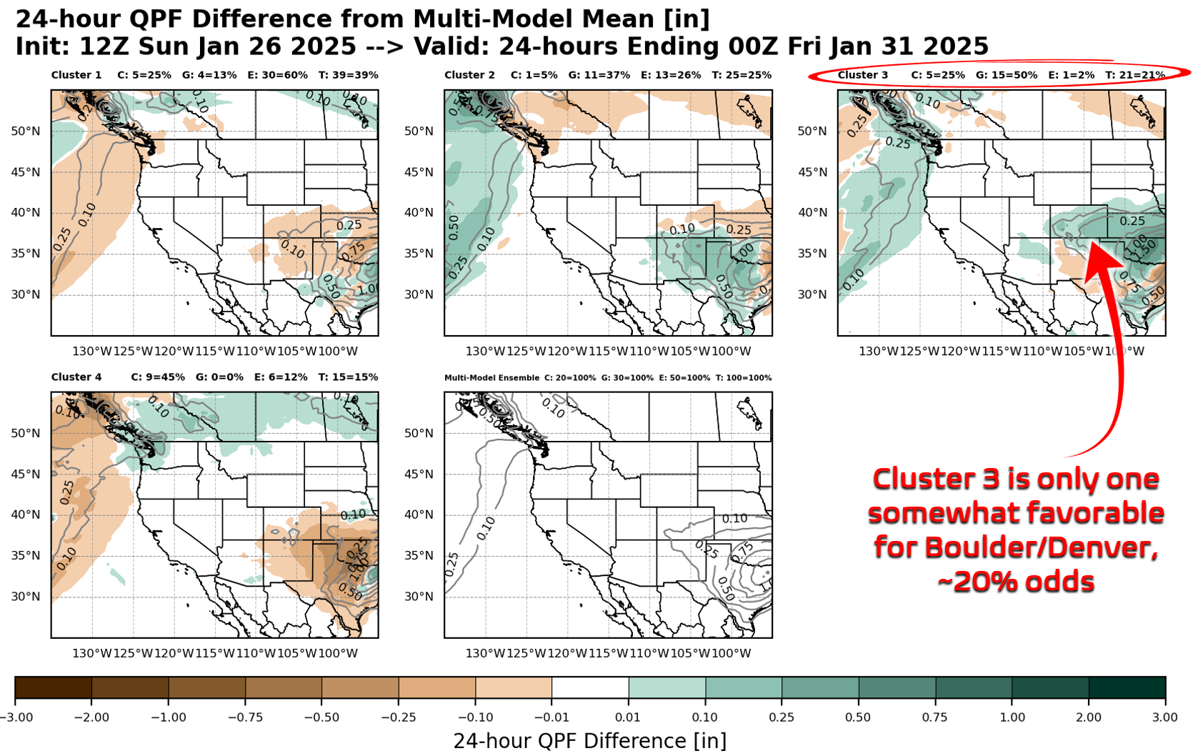
Models have generally been indicating the track of this low will be too far south to bring much impact to the Front Range later this week. However, about 20% of ensemble forecast members take the low pressure a tad further north and keep it stronger as it passes us by. This outcome is indicated by Cluster #3 below where the low tracks across far northern New Mexico. While 20% of all ensemble members fall into this cluster, most of those are part of the GFS suite — only one out of 50 European model members share this outcome.
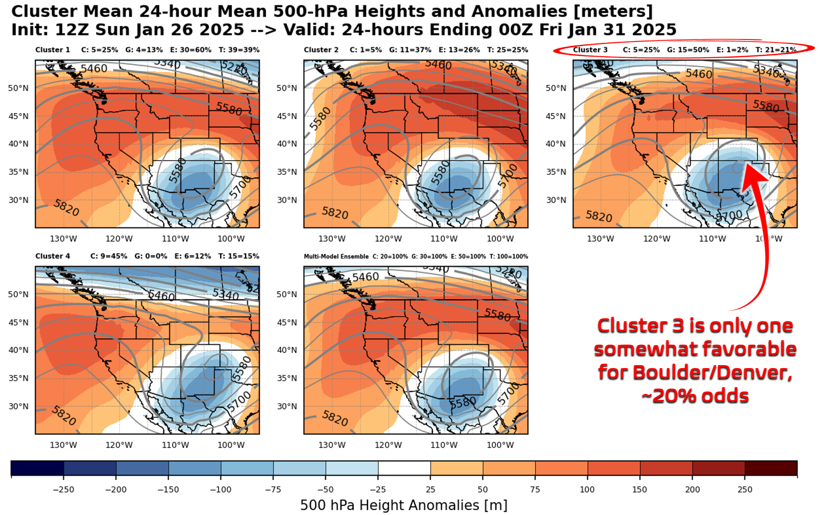
Cluster #3 would support a light snowfall event for northern Colorado (4″ or less), but has been declining in favor within the modelling suites of late. In general, the most likely outcome late-week is for this storm system to pass too far south with little consequence for the Front Range. This low pressure is lacking moisture and is on the warmer side for late January anyways.
The best chance for snow (Mountains) and rain/snow mix (lower elevations) will be across far southern Colorado Wednesday night through Thursday.
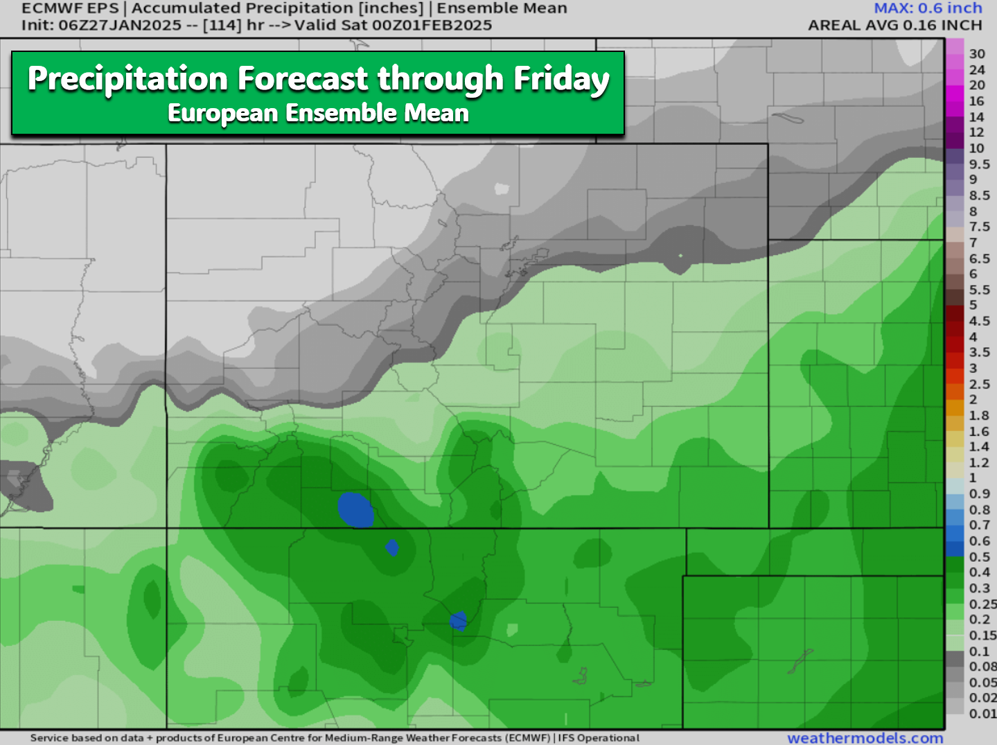
The Front Range is favored to be mostly dry late-week, but just be aware there is a chance of light snow Wednesday night through Thursday, with the best odds for seeing anything lying across southern Denver, the Palmer Divide and areas east of there.
After the low passes us by, a stronger ridge of high pressure will take control from the west leading to a warmer end to the week. Though there is still some uncertainty in exactly how toasty it will get, Friday should be our warmest day of the week as we push into the 50s — finally a break from the winter chill this January has spread. Enjoy!
Forecast Specifics:
Monday: Sunny skies and seasonal. Highs reach the 40s throughout the Metro area, with 30s in the Foothills.
Tuesday: Almost identical to Monday. Highs reach the 40s throughout the Metro area, with 30s in the Foothills.
Wednesday: A few clouds arrive late in the day, but otherwise lots of sunshine. High temperatures remain in the 40s on the Plains with 30s in the Foothills. There is a slight chance that light snow may spread into the area Wednesday night, mainly south of Denver.
Thursday: Partly cloudy with a chance of light snow showers, mainly south of Denver. Temperatures top out in the lower 40s on the Plains with lower 30s in the Foothills. Little to no snow accumulation is expected in Boulder or Denver.
Friday: Quiet weather returns with temperatures warming up about ten degrees. Morning sunshine will give way to increasing late-day clouds. Highs top out in the lower 50s on the Plains with upper 30s in the Foothills.
Weekend: Continued mostly quiet conditions in the Front Range as we stay on the warmer side of climatology. Highs should remain in the 50s through the weekend, with perhaps some places even challenging 60 degrees by Monday.
Get BoulderCAST updates delivered to your inbox:
DISCLAIMER: This weekly outlook forecast is created Monday morning and covers the entire upcoming week. Accuracy will decrease as the week progresses as this post is NOT updated. To receive daily updated forecasts from our team, among many other perks, subscribe to BoulderCAST Premium.
Go Premium, get all the perks.
Daily Forecast Updates
Get our daily forecast discussion every morning delivered to your inbox.
All Our Model Data
Access to all our Colorado-centric high-resolution weather model graphics. Seriously — every one!
Ski & Hiking Forecasts
6-day forecasts for all the Colorado ski resorts, plus more than 120 hiking trails, including every 14er.
Smoke Forecasts
Wildfire smoke concentration predictions up to 72 hours into the future.
Exclusive Content
Weekend outlooks every Thursday, bonus storm updates, historical data and much more!
No Advertisements
Enjoy ad-free viewing on the entire site.
Enjoy our content? Give it a share!


You must be logged in to post a comment.