As we rapidly approach the holiday season, the Front Range continues to experience unseasonably warm and dry conditions. This past weekend brought beautiful weather with temperatures warming into the 50s, accompanied by strong downslope winds at times. Looking ahead, the forecast remains mostly quiet with high pressure dominating the central Rockies, including Colorado. While a few bouts of wind are expected this week, precipitation will be nearly non-existent over the next seven to ten days, making a white Christmas highly unlikely for the Denver-Boulder area.
This week’s highlights include:
- Recent Weather: The past weekend was warm and dry across the Front Range, with temperatures in the 50s but with strong downslope winds on Sunday.
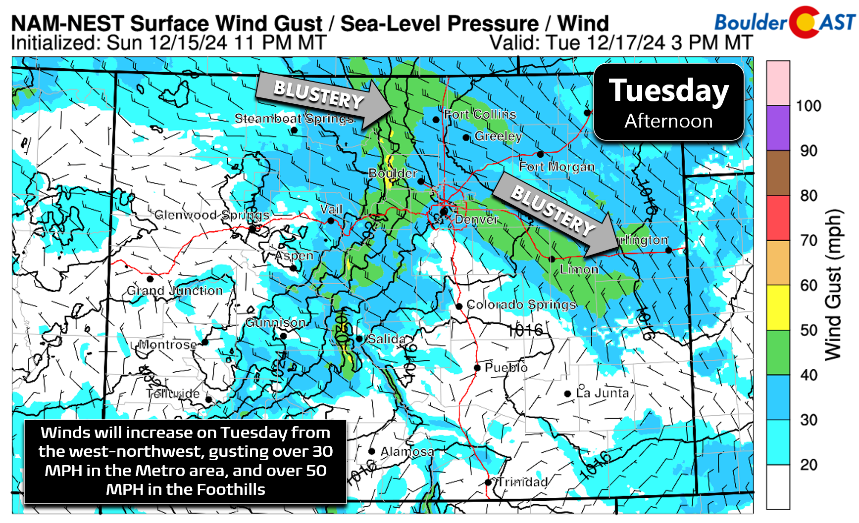
- Staying Quiet: The weather will remain mostly quiet with high pressure aloft. There will be a few windy periods, especially on Tuesday and possibly Wednesday night into Thursday morning.
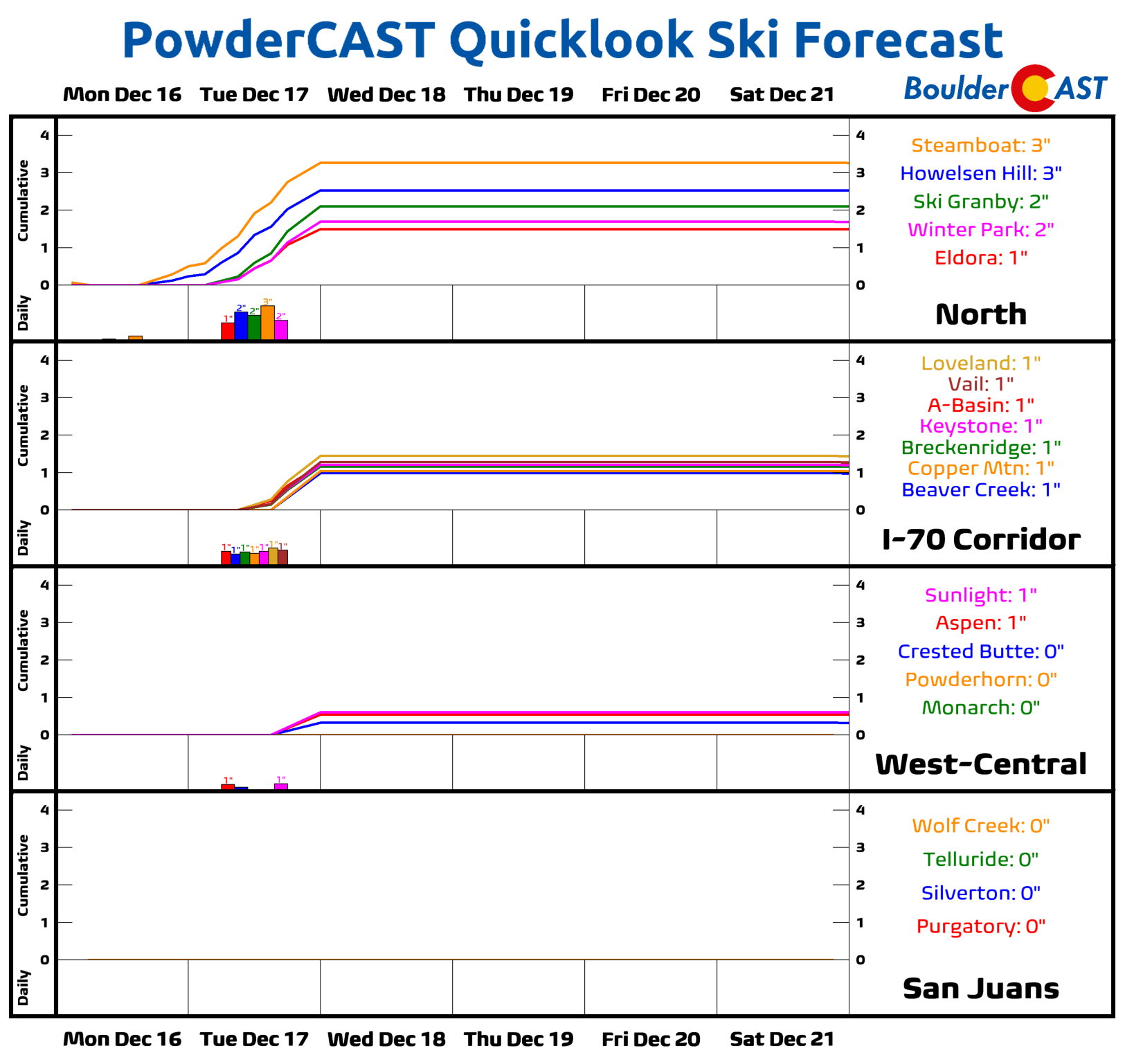
- No Precipitation (Again!): Minimal precipitation is expected throughout the week. A shortwave disturbance on Tuesday may bring 1 to 3 inches of snow to the Mountains north of Interstate 70, but the Plains will remain totally dry all week.
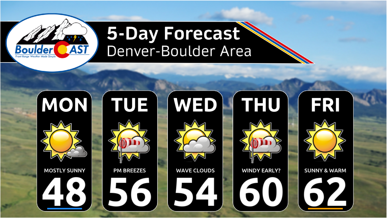
- Warmth Continues: Highs will be around 50 degrees on Monday, mid-50s on Tuesday and Wednesday, and lower 60s on Thursday and Friday.
- White Christmas? Nope! The pattern of warm and dry weather is expected to continue into the weekend and early next week, making a white Christmas highly unlikely for the Denver-Boulder area.
DISCLAIMER: This weekly outlook forecast is created Monday morning and covers the entire upcoming week. Accuracy will decrease as the week progresses as this post is NOT updated. To receive daily updated forecasts from our team, among many other perks, subscribe to BoulderCAST Premium.
Daily Forecast Updates
Get our daily forecast discussion every morning delivered to your inbox.
All Our Model Data
Access to all our Colorado-centric high-resolution weather model graphics. Seriously — every one!
Ski & Hiking Forecasts
6-day forecasts for all the Colorado ski resorts, plus more than 120 hiking trails, including every 14er.
Smoke Forecasts
Wildfire smoke concentration predictions up to 72 hours into the future.
Exclusive Content
Weekend outlooks every Thursday, bonus storm updates, historical data and much more!
No Advertisements
Enjoy ad-free viewing on the entire site.
Continued warm & dry weather will lead into a brown Christmas
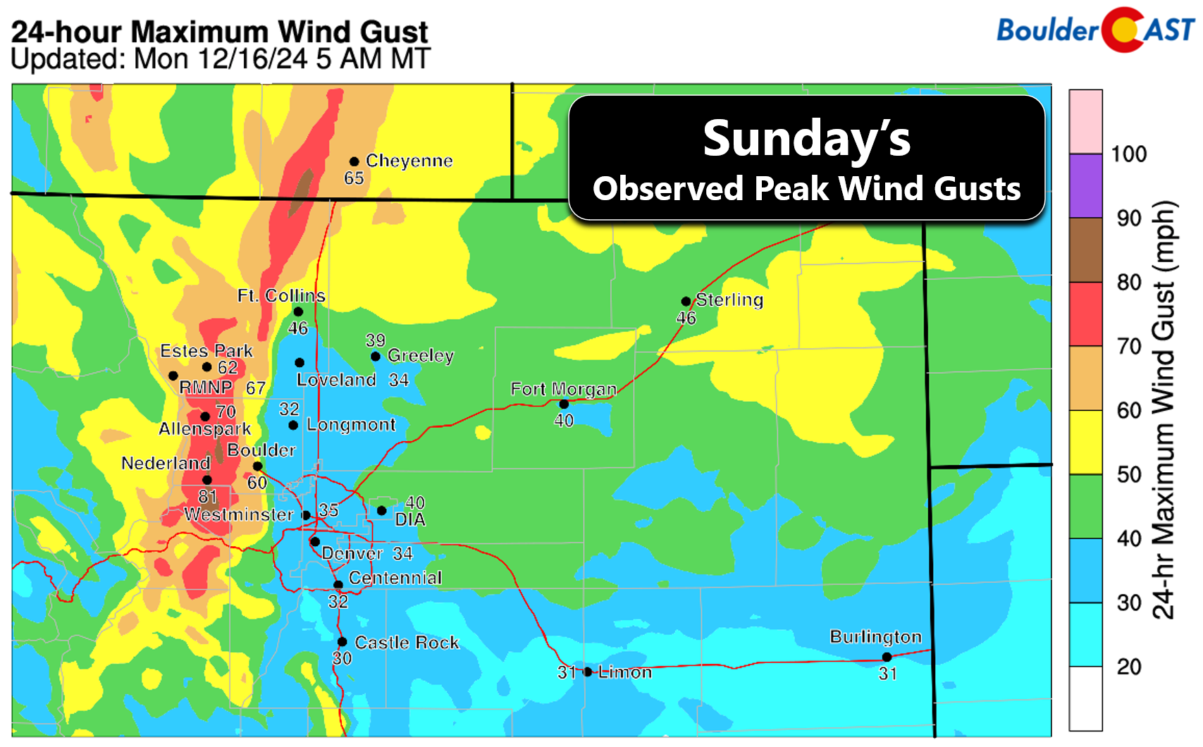
This past weekend was gorgeous across the Front Range with high temperatures well above normal in the 50s both days. The only weather concern was the strong downslope winds observed on Sunday, with gusts reaching over 55 MPH in and (very) near to the Foothills, and maximum gusts of 30 to 40 MPH across most of the lower elevations. Sunday’s peak wind gusts are shown below.
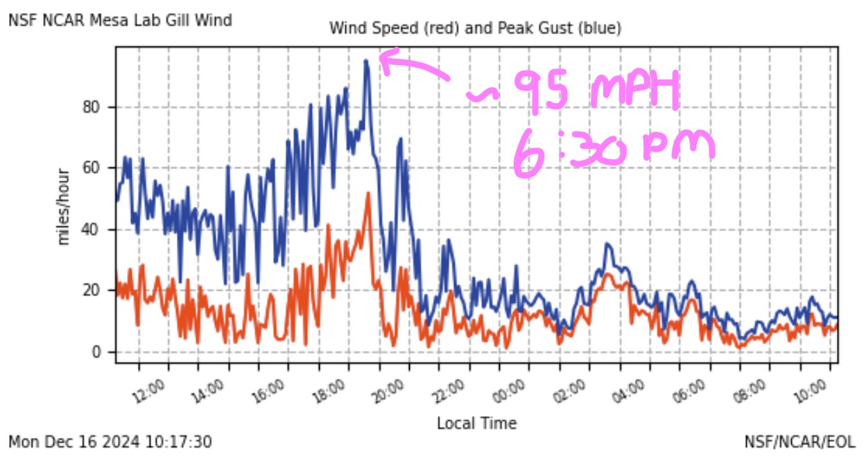
The highest reported winds occurred at NCAR in south Boulder which saw one or two gusts over 90 MPH Sunday evening just after sunset!
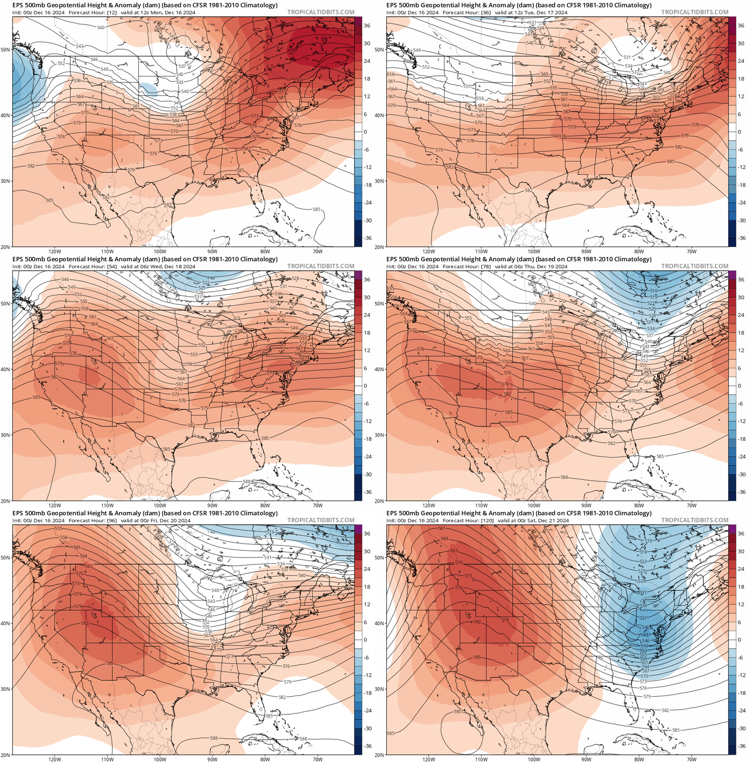
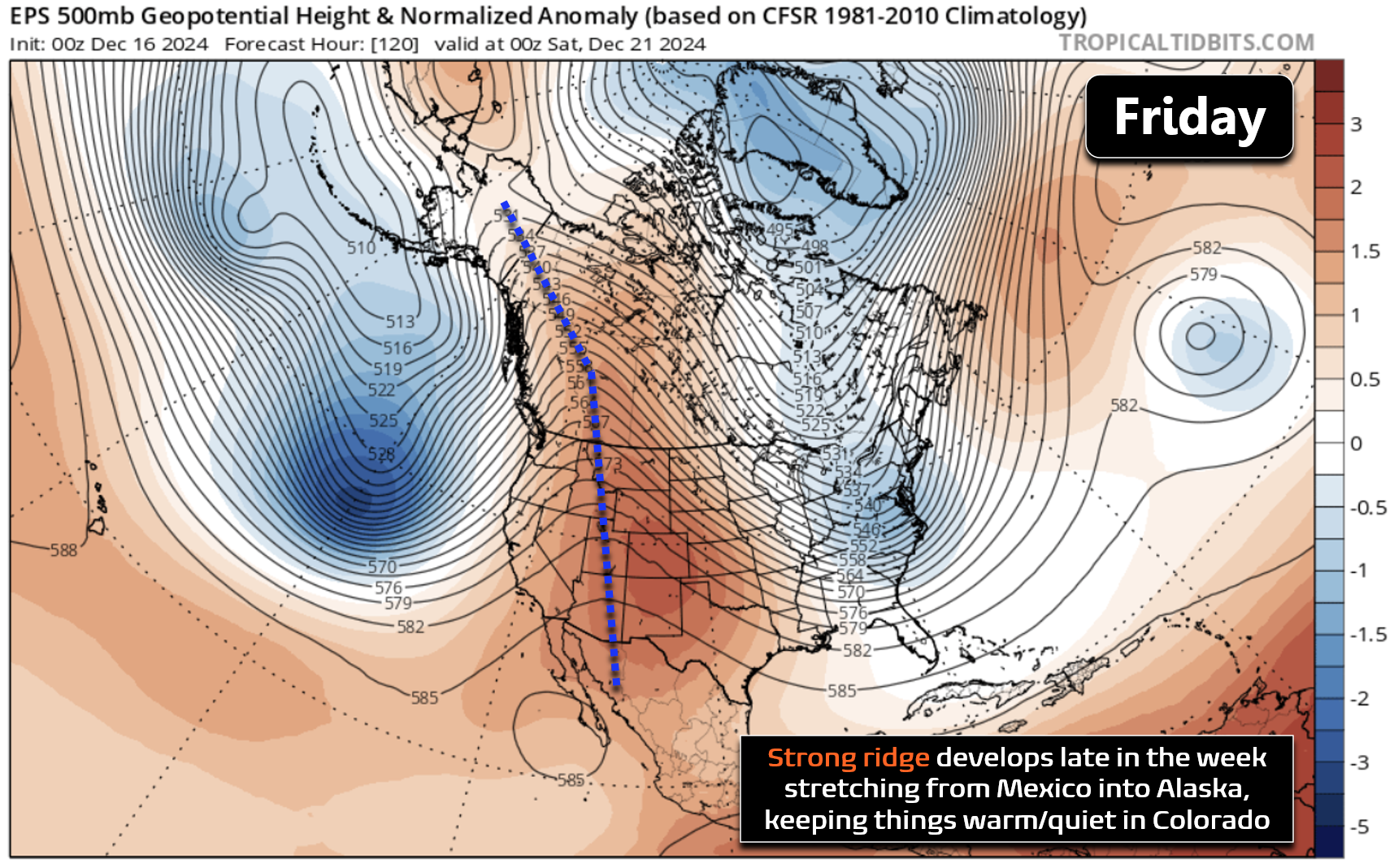
The weather week ahead in Colorado will feature a few more potentially brief windy periods, but for the most part it will be a largely quiet week under continued high pressure aloft. The forecast animation below shows the European ensemble mean 500mb height anomalies through Friday evening. Keep an eye on Colorado — though there will be a couple weak passing shortwaves sliding across the northern Rockies, the general pattern across the West will be continued, persistent ridging. This is especially true as we head late in the week when a more potent ridge will setup along the spine of the Rockies beginning Thursday night.
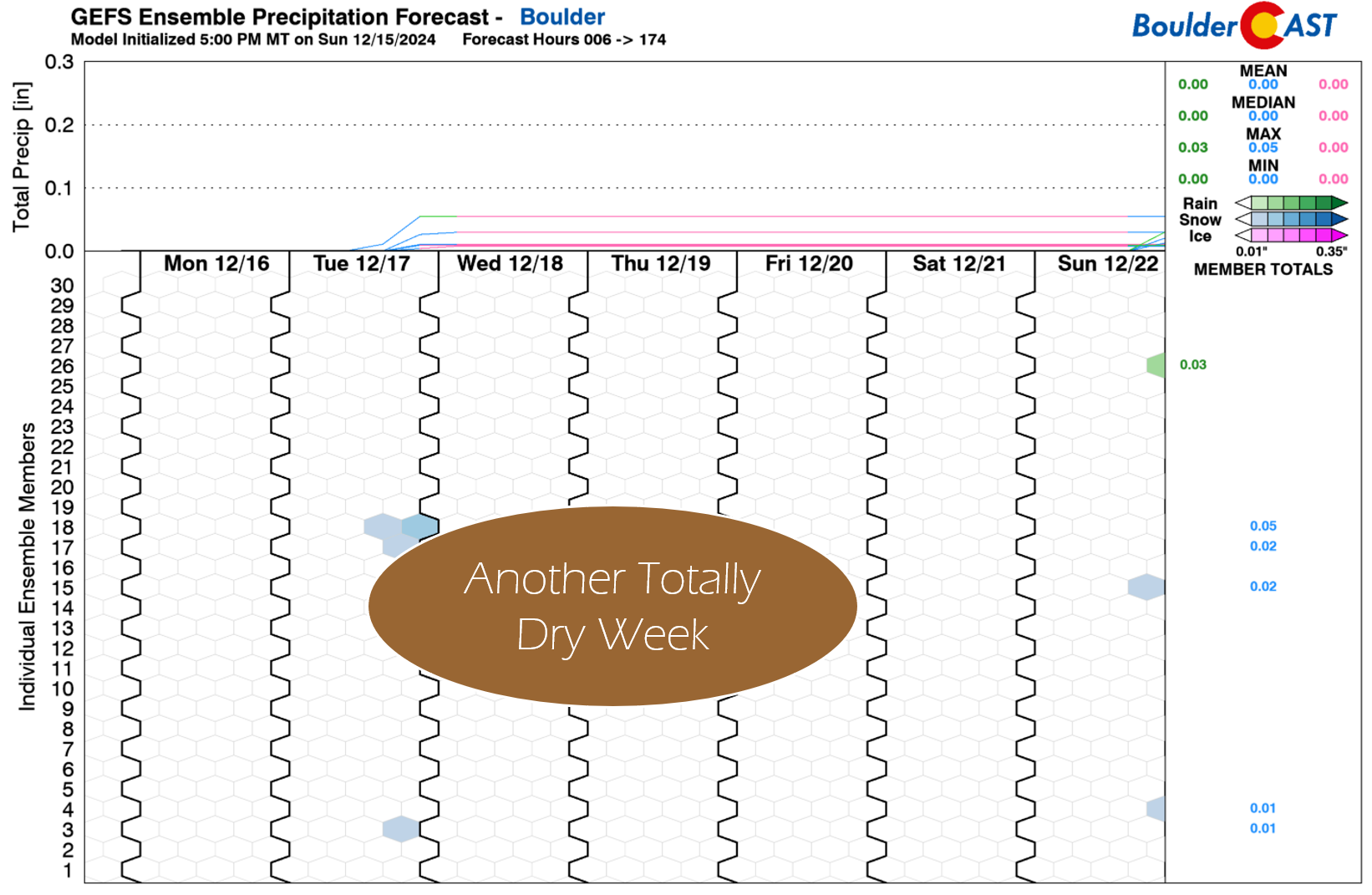
For precipitation, this week will barely have any at all thanks to this ridgy atmospheric setup. We are expecting another totally dry week east of the Mountains in Boulder and Denver.
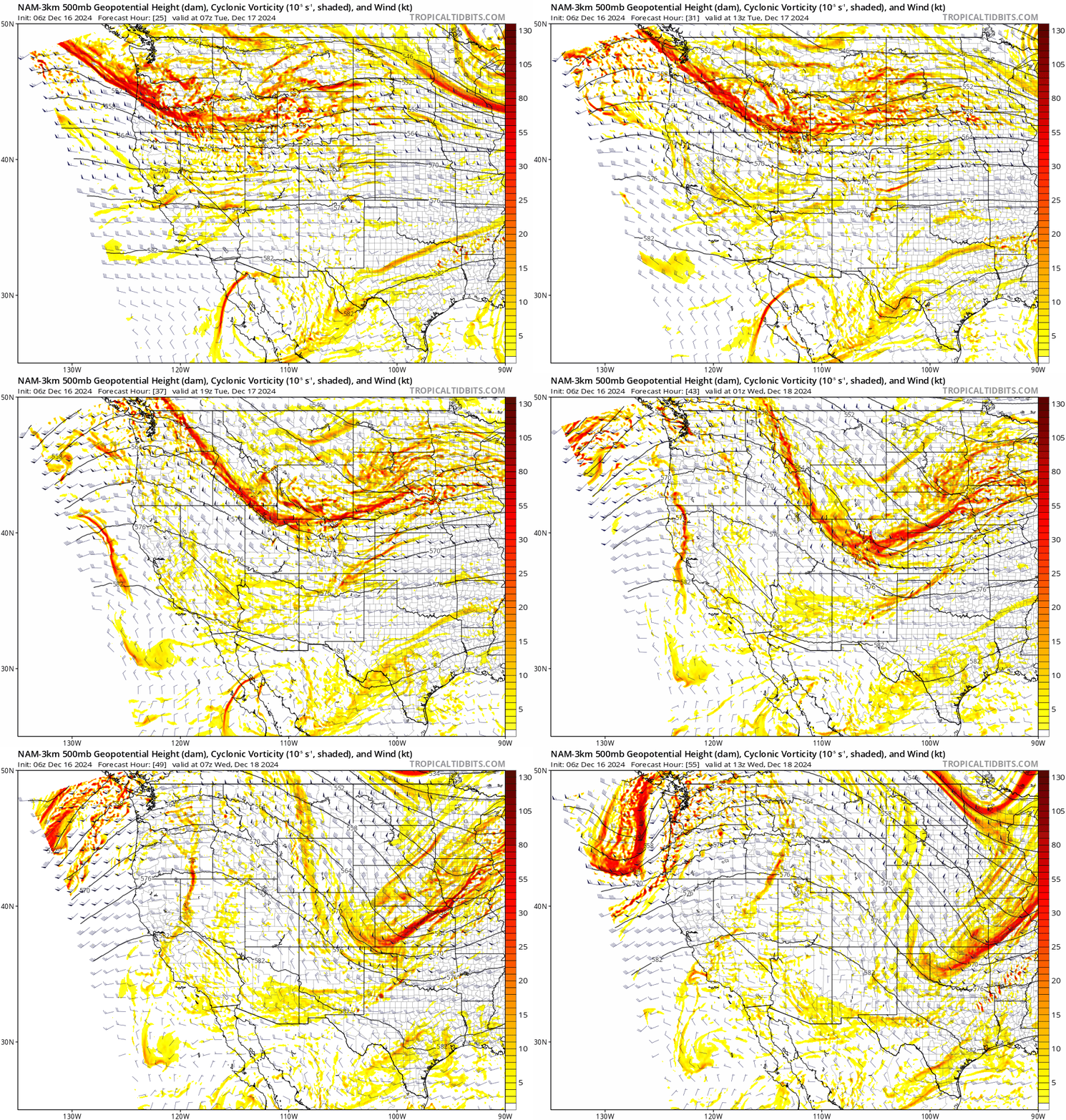
Tuesday’s shortwave disturbance will bring the only real chance of precipitation to the state this week. This shortwave is shown in the animation below, with a slight dip in the height lines nosediving across northeast sections of Colorado Tuesday afternoon and evening.
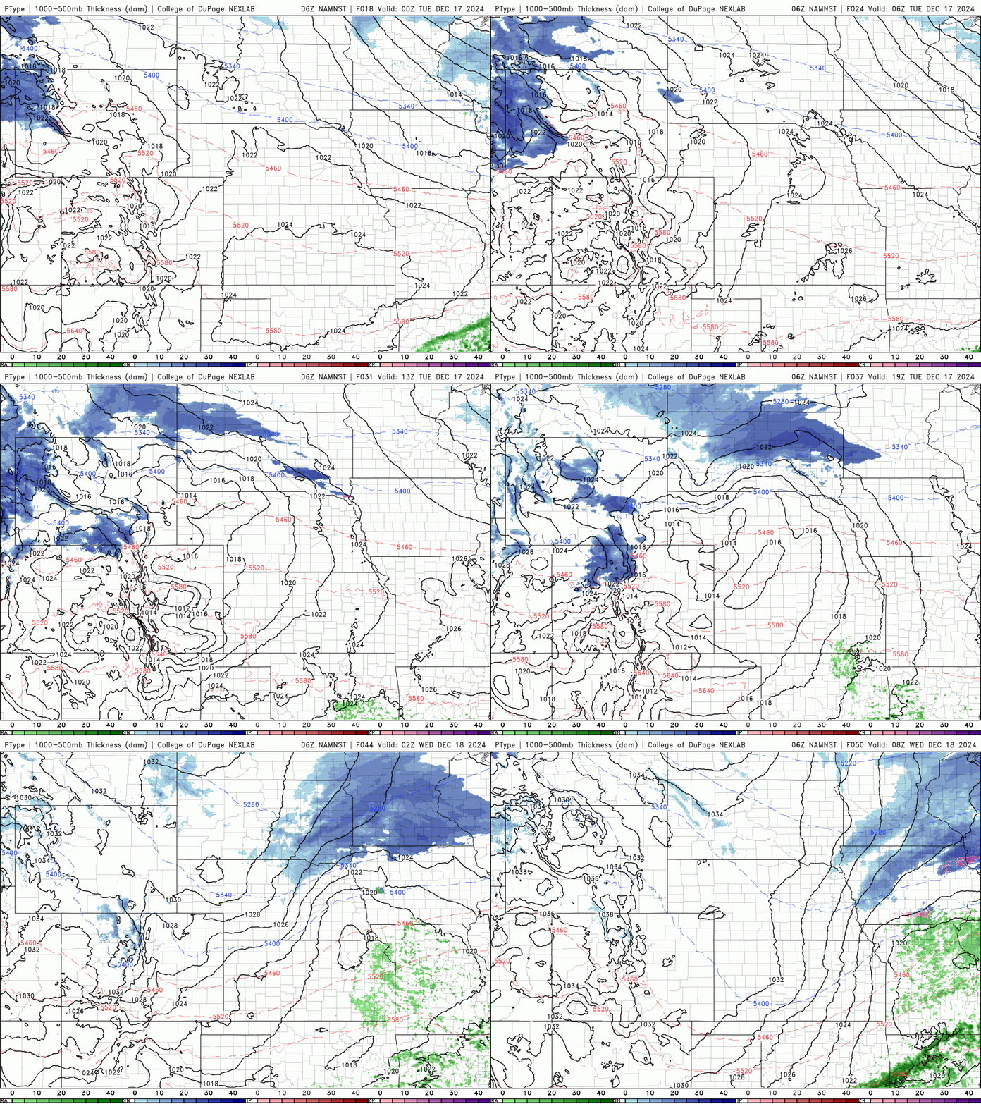
While moisture will be fairly limited with this disturbance, there should be enough to produce a couple inches of snow in the Mountains north of Interstate 70.
PowderCAST is favoring the Steamboat and Winter Park areas for 1-3″ of snow on Tuesday, with little elsewhere across the state as things pass too far north.
East of the Mountains, the story Tuesday will be partly cloudy skies and increasing winds through the day. Gusts over 25 MPH will be possible for most areas through the afternoon into evening, with gusts over 50 MPH in the Foothills.
Monday’s high temperatures will be close to 50 degrees with lots of sun, while Tuesday should get into the middle 50s with more clouds around.
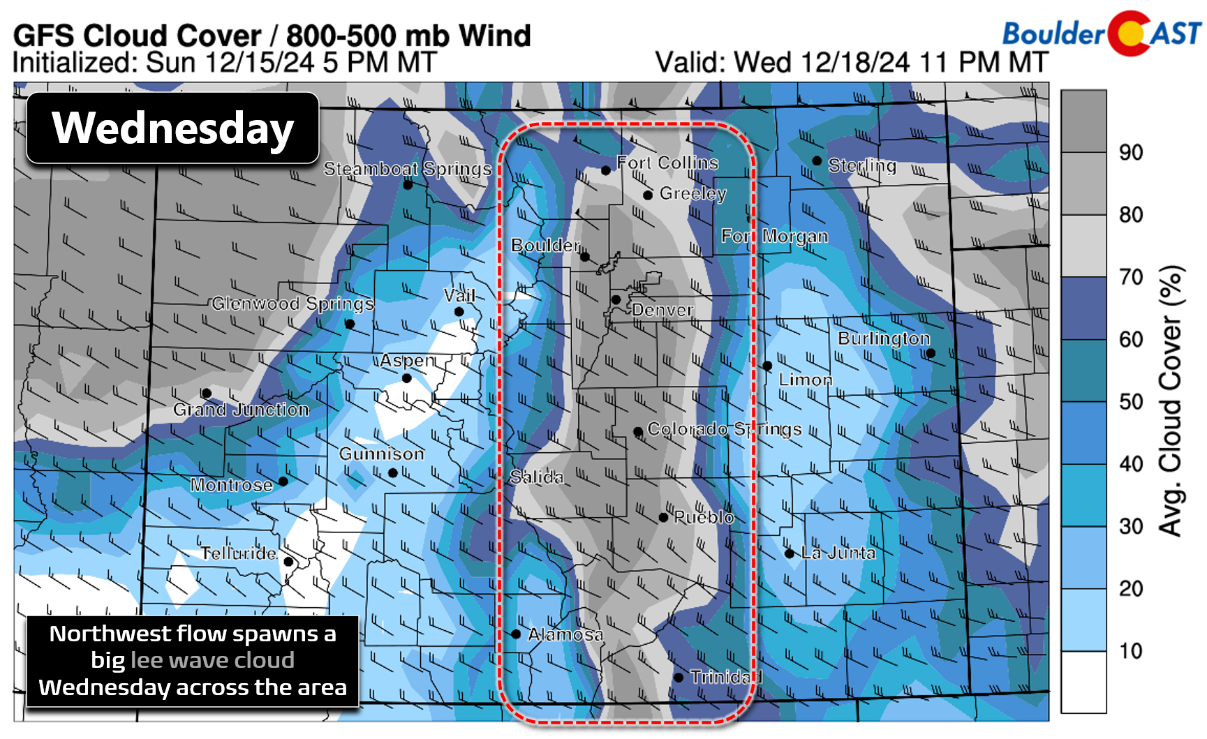
Wednesday will be quiet across the state with persistent wave clouds lingering above the Front Range. Temperatures will remain in the middle 50s but perhaps drop slightly under the increased clouds. Most model suites are then advertising a mountain wave setup developing Wednesday night over the Continental Divide which could linger into early Thursday. If this verifies, downslope winds may significantly ramp up along on the eastern slopes of the Foothills into the adjacent Plains, including Boulder. The current window to watch for strong downslope winds is 6PM Wednesday through 6AM Thursday, but things could change as predicting high winds many days in advance is generally not recommended nor easy.
For Thursday and Friday, we’ll see a nice jump in our temperatures back into the lower 60s with dry conditions as the aforementioned stronger ridge sets up over the West. In fact, this late-week ridge amazingly will stretch from the Deserts into the Arctic — not really what you want to see just a handful of days before Christmas…more on that in a moment.
Here’s a look at the extended forecast for the week. As mentioned, it will be totally dry in the Denver-Boulder area with temperatures sticking well above normal most days. The only weather concerns for us are the two periods of winds — Tuesday PM and then possibly Wednesday night into Thursday morning.
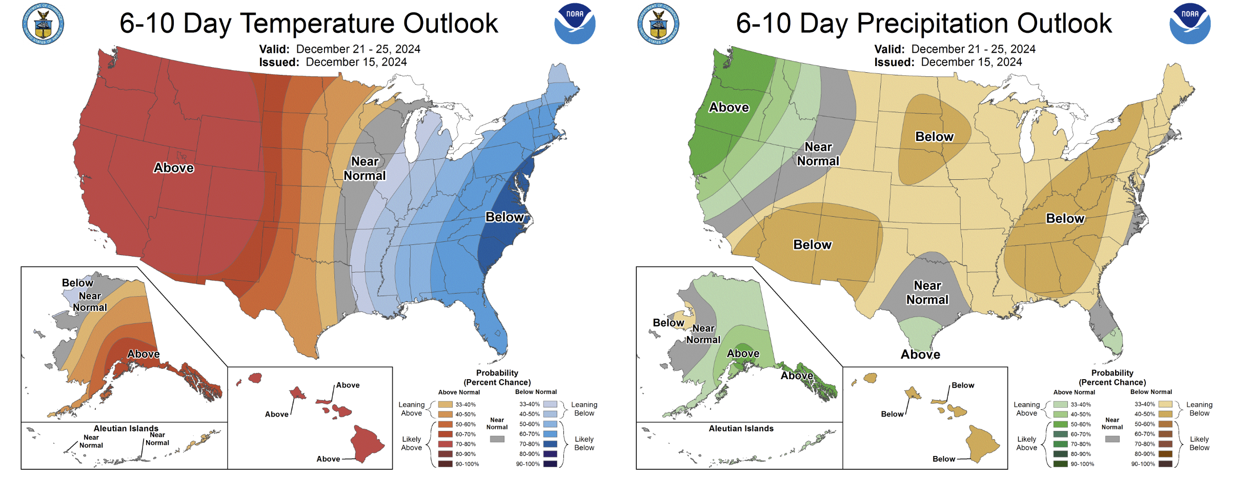
The weekend ahead into early next week won’t see this pattern drastically change either, with a (very) high probability for above normal temperatures and below normal precipitation in the stretch of days leading up to Christmas.
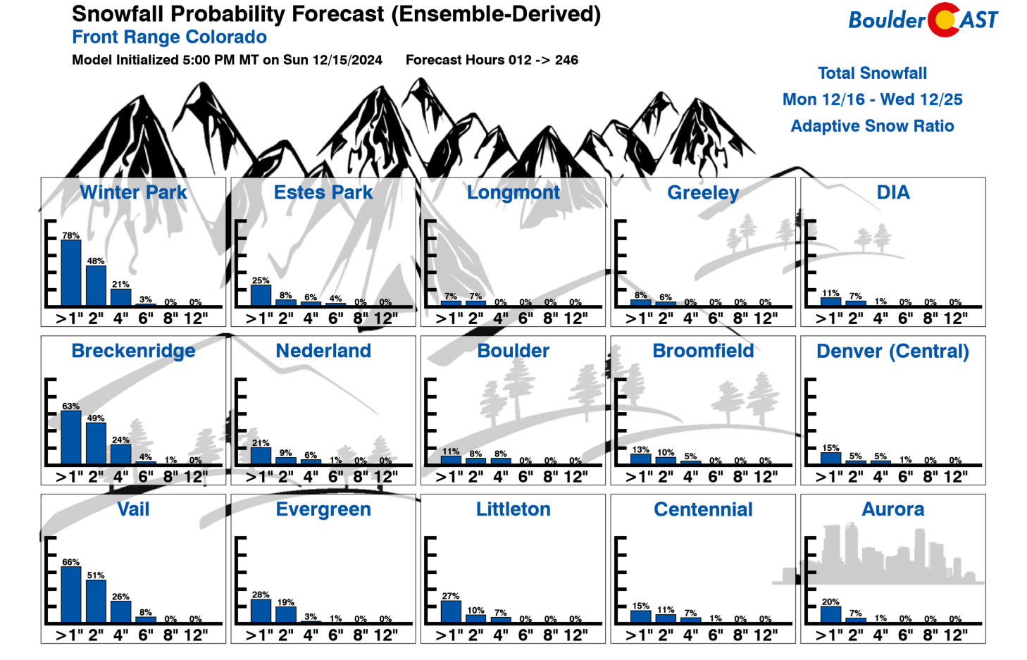
Our latest 10-day accumulated Snowfall Probabilities paint a similarly bleak picture for the Front Range — with generally less than 10% chances to see 1″ of snow between now and Christmas Day. Sorry to be the bearer of bad news, but a white Christmas appears exceptionally unlikely at this point, unless you head west and up in elevation where snowpack is deep…
Forecast Specifics:
Monday: Mostly sunny and seasonal with highs around 50 degrees on the Plains and in the lower 40s in the Foothills.
Tuesday: Mild with a mix of clouds and sunshine. Winds will ramp up during the afternoon and evening, especially in the Foothills and along the Wyoming Border. High temperatures in the middle 50s on the Plains with lower 40s in the Foothills.
Wednesday: Some sun, but skies will be filled with lots of wave clouds. Temperatures remain mild in the low to middle 50s on the Plains with lower 40s in the Foothills. Strong downslope winds may develop Wednesday night in and near the Foothills, lingering into Thursday morning.
Thursday & Friday: Partly to mostly sunny, warm and dry. Look for temperatures to top out in the lower 60s on the Plains with near 50 degrees in the Foothills.
Weekend: Likely staying warm with highs in the middle 50s to middle 60s, with this variation depending on how a few weak shortwaves interact with our local airmass.
Get BoulderCAST updates delivered to your inbox:
DISCLAIMER: This weekly outlook forecast is created Monday morning and covers the entire upcoming week. Accuracy will decrease as the week progresses as this post is NOT updated. To receive daily updated forecasts from our team, among many other perks, subscribe to BoulderCAST Premium.
Daily Forecast Updates
Get our daily forecast discussion every morning delivered to your inbox.
All Our Model Data
Access to all our Colorado-centric high-resolution weather model graphics. Seriously — every one!
Ski & Hiking Forecasts
6-day forecasts for all the Colorado ski resorts, plus more than 120 hiking trails, including every 14er.
Smoke Forecasts
Wildfire smoke concentration predictions up to 72 hours into the future.
Exclusive Content
Weekend outlooks every Thursday, bonus storm updates, historical data and much more!
No Advertisements
Enjoy ad-free viewing on the entire site.
Enjoy our content? Give it a share!





You must be logged in to post a comment.