Temperatures across the Front Range will remain unseasonably warm for much of the week ahead pushing into the 70s and 80s. Precipitation will once again be vacant from the forecast early this week with no major weather systems to speak of. However, that all changes as we head into Friday and the weekend as our team is tracking a strong storm system that is taking aim on Colorado. Rather large uncertainty still remains in the exact outcome for us, but we discuss the odds of seeing our first snow and/or much-needed rainfall.
This week’s highlights include:
- More Dry Weather: Front Range Colorado will remain warm and dry with temperatures in the 70s and lower 80s much of the week ahead
- The Pattern Shift We’ve Been Waiting For? A pattern shift is expected late this week and weekend, as a strong storm system takes aim on the state.
- Rain & Snow Chances Rise by Friday: The late-week pattern change could bring our first chance of snow but plenty of uncertainty remains with low confidence. At minimum, we should see at least a small amount of rain (less than 0.5″)
DISCLAIMER: This weekly outlook forecast is created Monday morning and covers the entire upcoming week. Accuracy will decrease as the week progresses as this post is NOT updated. To receive daily updated forecasts from our team, among many other perks, subscribe to BoulderCAST Premium.

Go Premium, get all the perks.
Daily Forecast Updates
Get our daily forecast discussion every morning delivered to your inbox.
All Our Model Data
Access to all our Colorado-centric high-resolution weather model graphics. Seriously — every one!
Ski & Hiking Forecasts
6-day forecasts for all the Colorado ski resorts, plus more than 120 hiking trails, including every 14er.
Smoke Forecasts
Wildfire smoke concentration predictions up to 72 hours into the future.
Exclusive Content
Weekend outlooks every Thursday, bonus storm updates, historical data and much more!
No Advertisements
Enjoy ad-free viewing on the entire site.
Staying warm and dry to start
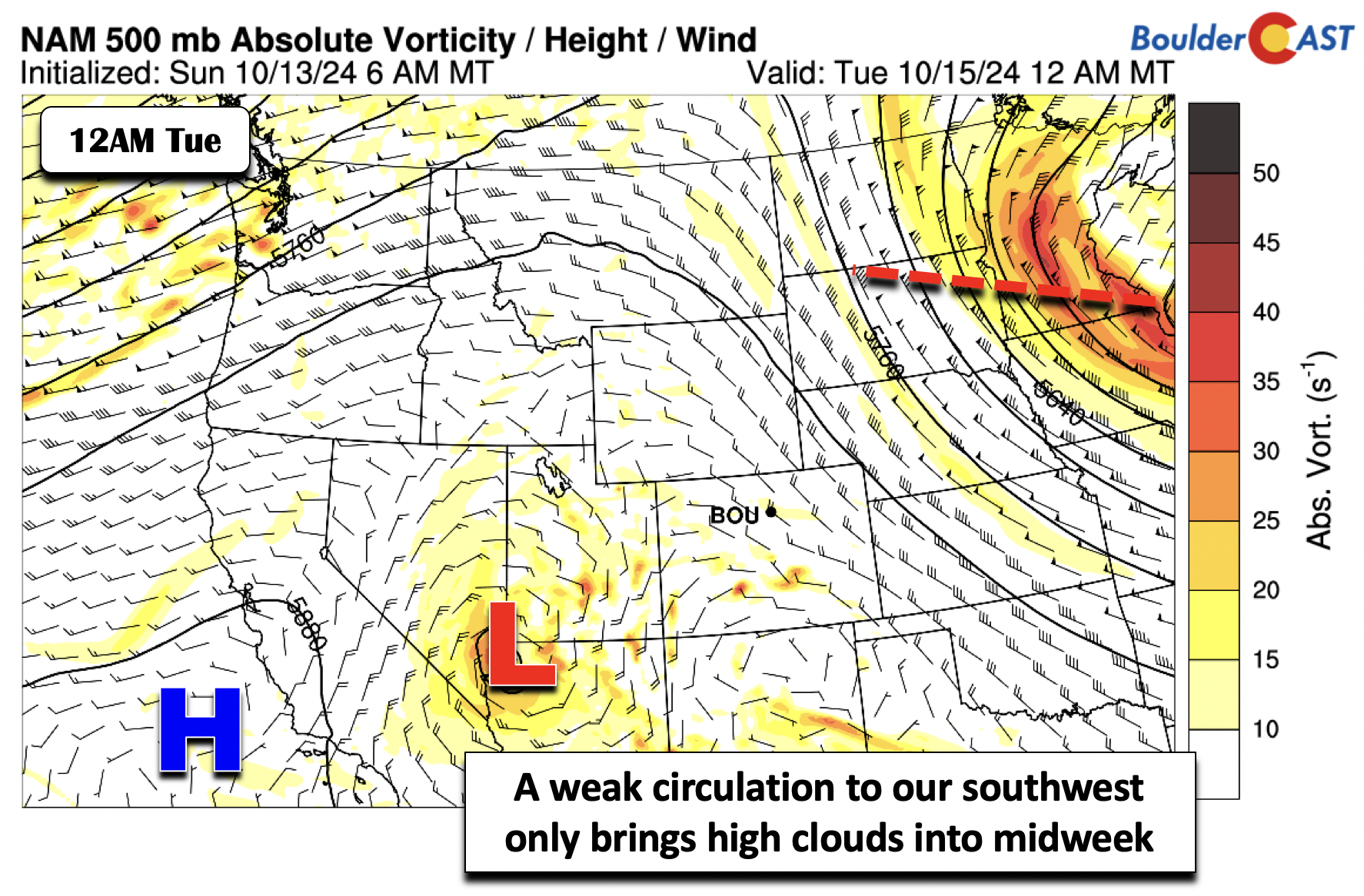
Our week starts off rather benign. Though it is quiet, the atmosphere aloft is doing something! We have a weak and closed area of low pressure situated across northwest Arizona on Monday. Over the course of the next several days into Wednesday, it will slowly jog to the south and east, but remains to our west-southwest. Weak ridging over the area will keep our weather dry. The only influence we will see from this low will be occasional mid- and high-level cloudiness from time to time.
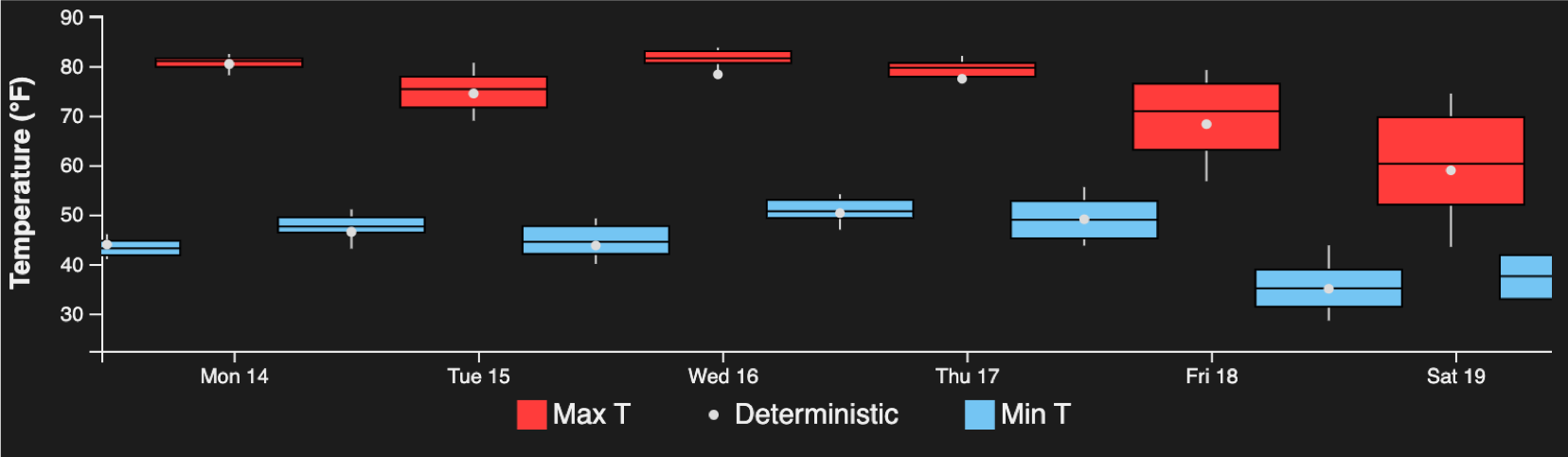
We continue to roller-coaster ride in temperatures. Yesterday (Sunday) had a high temperature only in the mid to upper 60s. For Monday, we warm back into the lower 80s under partly to mostly sunny skies.
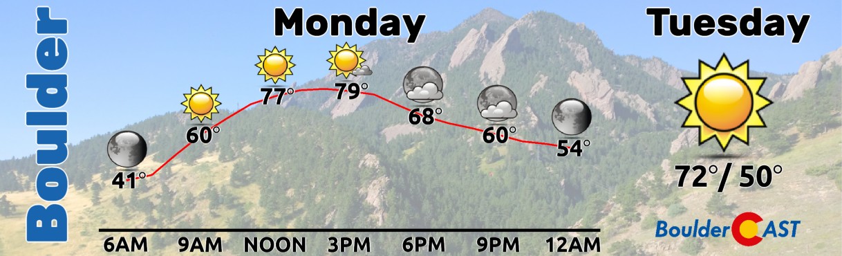
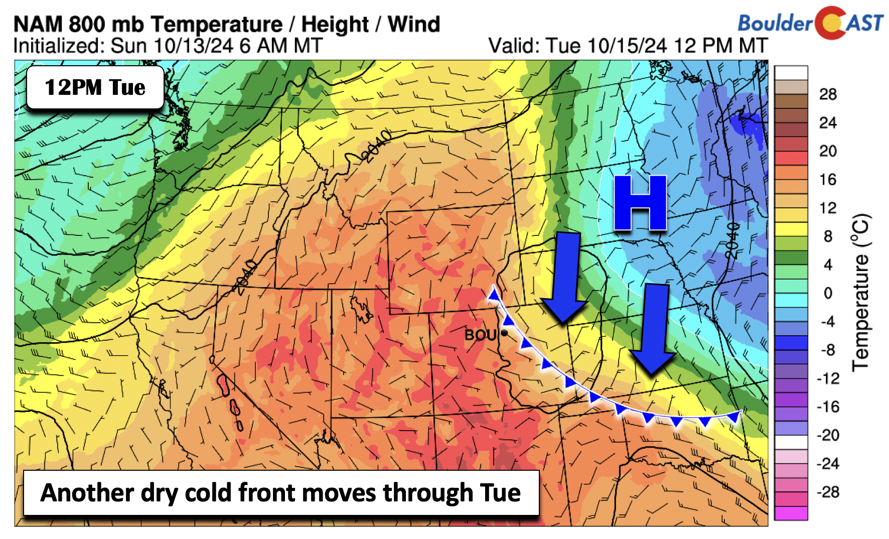
Then, yet another dry cold front moves through Tuesday morning, returning us back into the 70s for a short period of time. Come midweek, this cooler air will shift well off to the east, and actually bring some well below normal weather to the East Coast. As the cooler airmass moves away from us, we’ll see that unseasonably warm weather takeover again Wednesday and Thursday.
Watching a late-week storm for our first…snow?
The more interesting weather will potentially take place late this week or later this weekend. The GFS, and as we will show a bit later, the GEFS, both show a potent trough closing off from the flow and perhaps bringing our best shot of precipitation to the area in quite some time. If the system were to track just right, it could also bring down cold enough air for our first snow over the High Country and perhaps even the Denver Metro area. That “perhaps” certainly comes with a caveat: there is not good model agreement for lower elevation snow thus far.
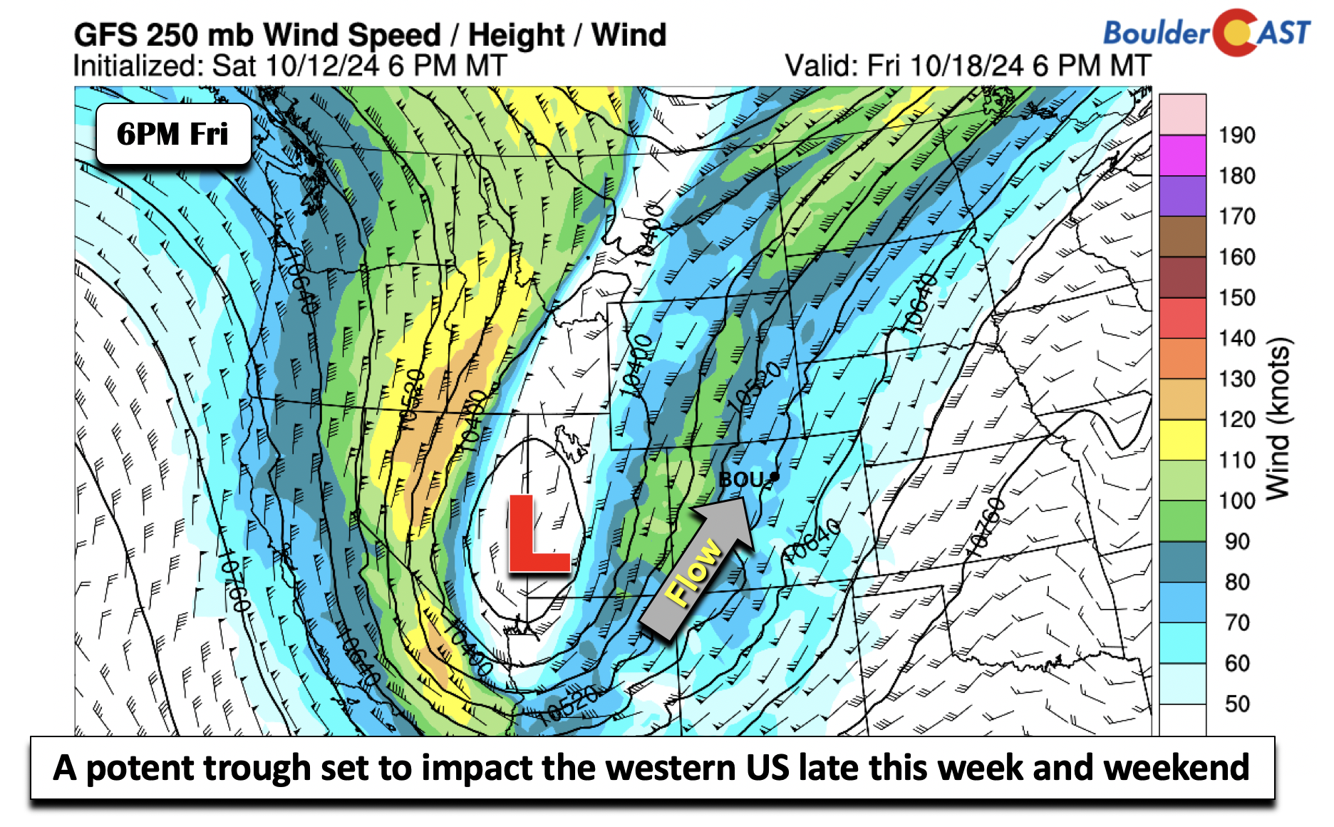
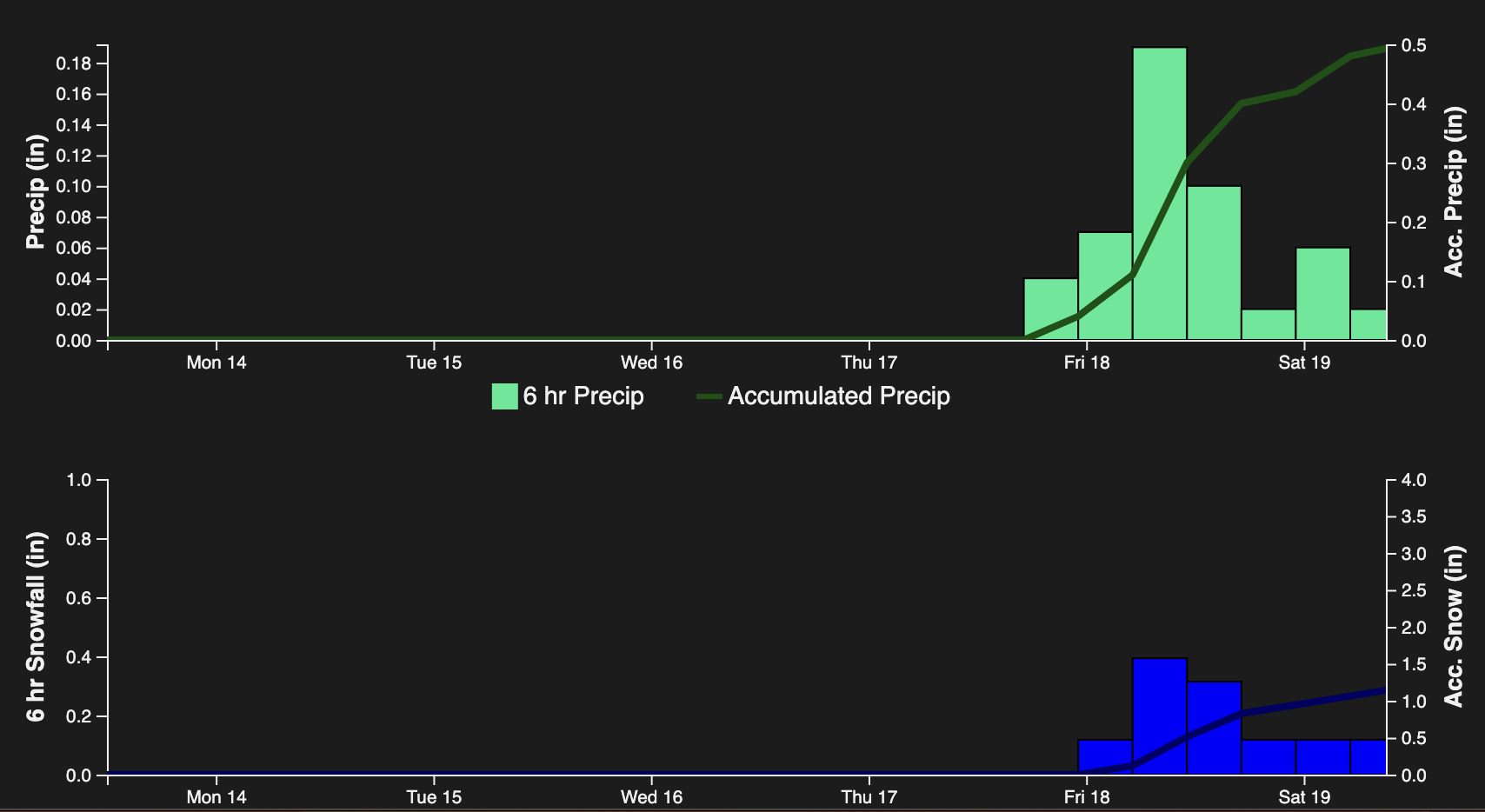
As ridging will build back in midweek, we should see southwest flow take over aloft and send us back into the 80s. All guidance then shows a trough of some sort moving inland off the West Coast late Thursday or Friday. Looking at the National Blend of Models (aka NBM, which is a blend of various global, regional, and ensemble data), it shows accumulating precipitation for the Denver Metro Friday into the weekend. It also shows a hint of snow, upwards of about an inch. Whether it rains or snows or both is the BIG question.
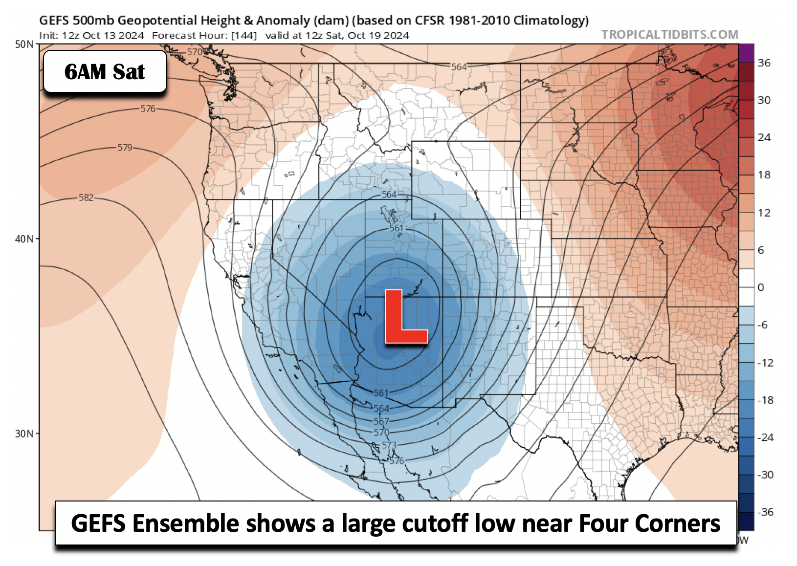
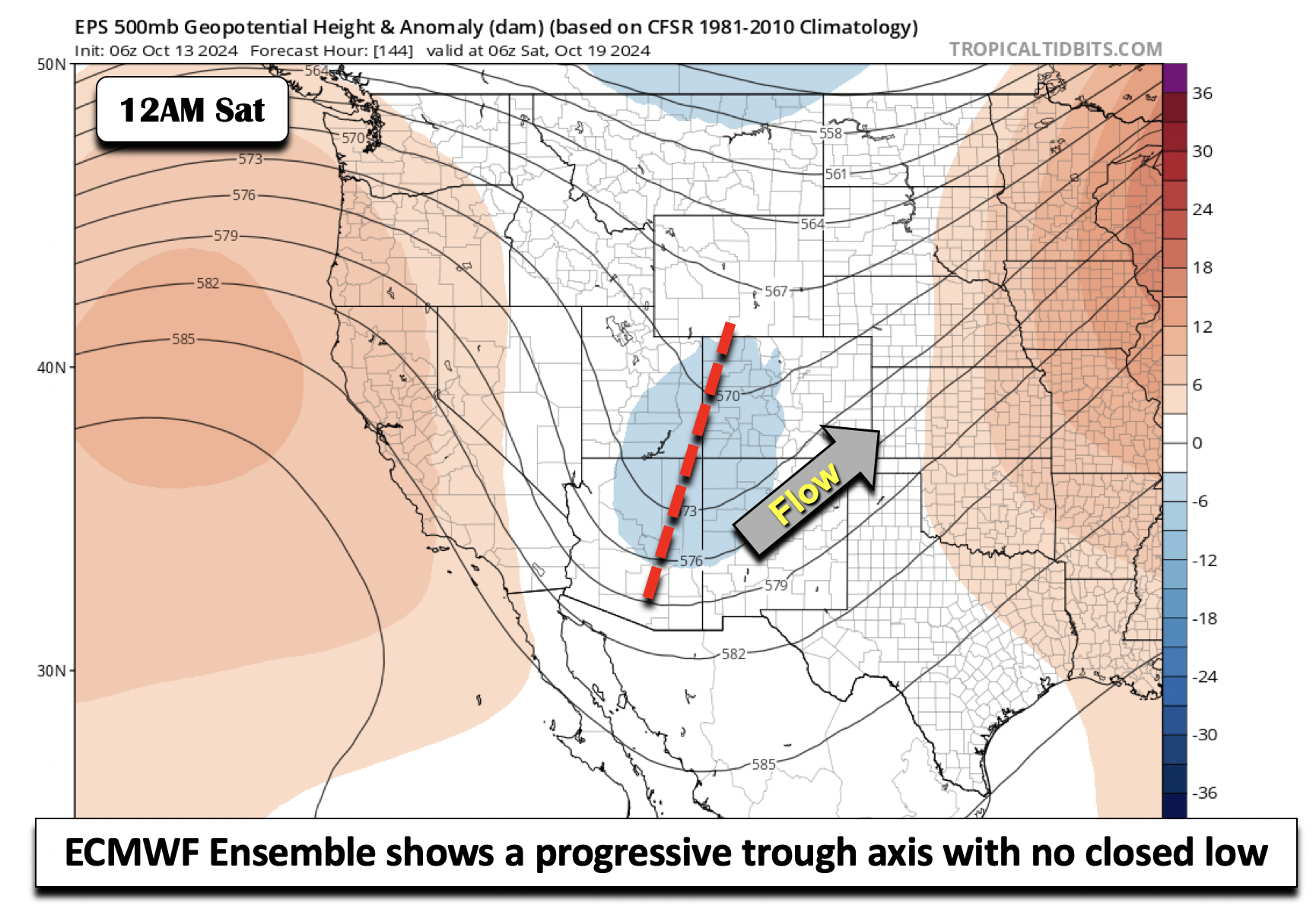
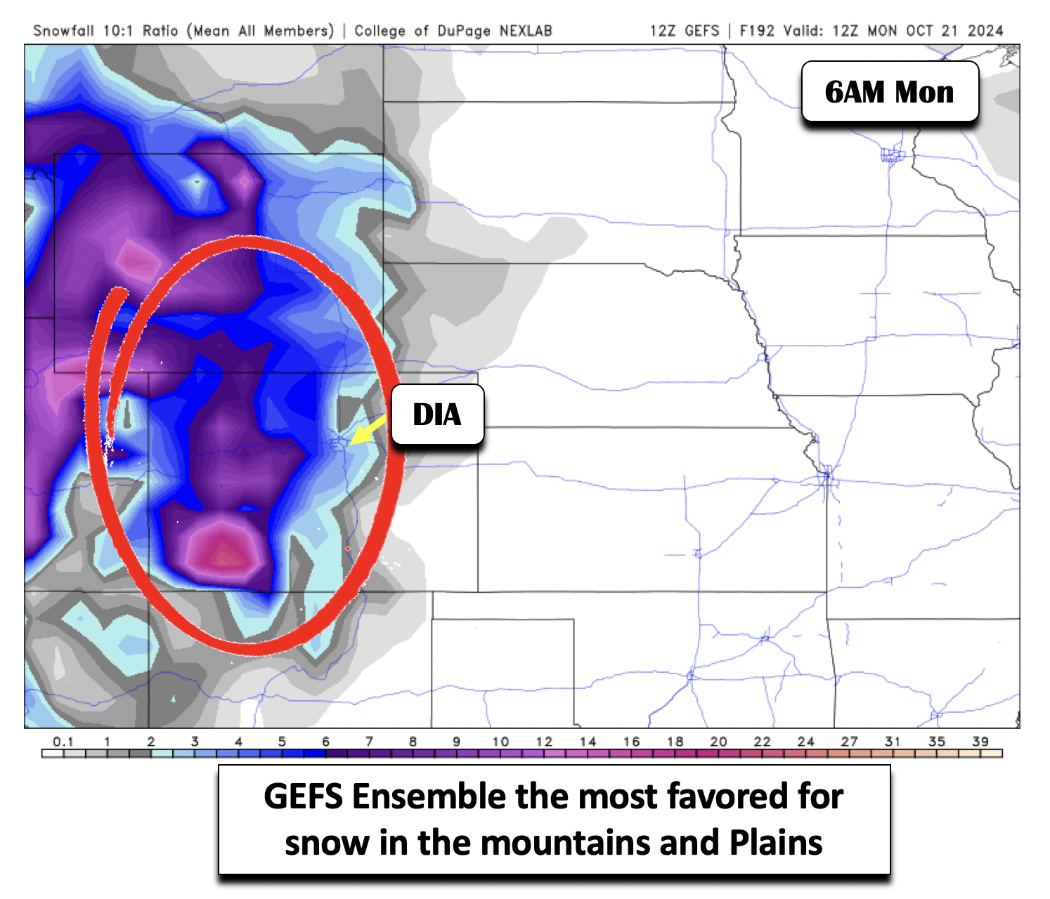
For the next three images, we’re going to show several possible scenarios (via 500-mb height anomalies from the GEFS, GEPS, and EPS) which could occur based on the latest model guidance. This is just to show that there is rather low confidence late this week, but certainly this storm bears watching. The figure below shows the GEFS ensemble mean solution for early Saturday. The GEFS is the GFS ensemble. It shows a very strong and wrapped-up trough of low pressure just southwest of the Four Corners, which persists into early next week as a result of a blocking ridge to our east. This solution would bring a prolonged period of moisture and lift, as well as terrain upslope to the High Country for snow and low elevation rain. For the Denver Metro area, its uncertain, but this setup could bring both a mix of rain and snow, depending on how it tracks eastward.
The ECMWF’s ensemble, the EPS, shows a much different picture. It depicts simply a trough axis spreading from west to east. This solution would bring moisture and lift for the higher terrain and likely precipitation there. But for the Plains, we’d likely see mostly downslope westerly flow with little to no expected rain or snow.
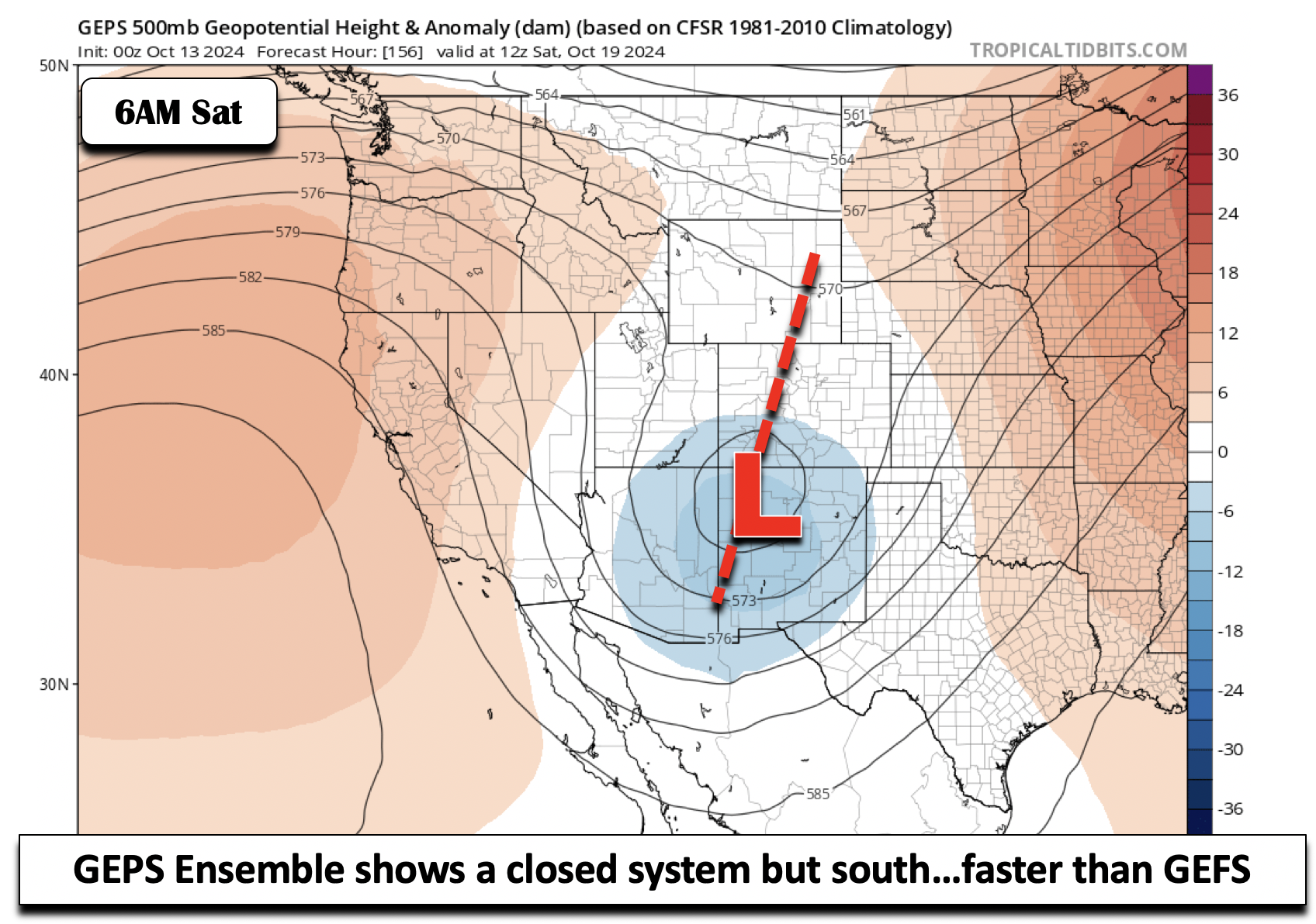
Finally, the GEPS, the Global Ensemble Prediction System, or the Canadian ensemble, lands in between the EPS and GEFS. It is not as strongly closed-off as the GEFS, but also not as weak and progressive as the EPS. Nevertheless, this solution would not do much for us in the Front Range as it slides off to the east-southeast.
Lots of uncertainty, huh? That’s for sure! The GEFS solution, which at this point we could say is the worst case, shows several inches of snow in the mountains by early next week, and perhaps our first flakes over the Denver Metro. If you were to look at the other solutions, you’d see a much drier picture.
All this is to say that what happens Friday through early next week is still up in the air. The NBM high temperatures show little spread through Thursday, but much larger uncertainty Friday and Saturday, all dependent on the pattern and whether deep cold air can make it into the region. Highs Friday could range anywhere from the upper 50s to near 80°, more than a 20 degree spread! For now, our forecast on Friday will call for highs in the low to middle 70s with a slight chance of late-day showers. A better chance of rain currently exists for Saturday and Sunday, but that really depends on how the low pressure to our west evolves.
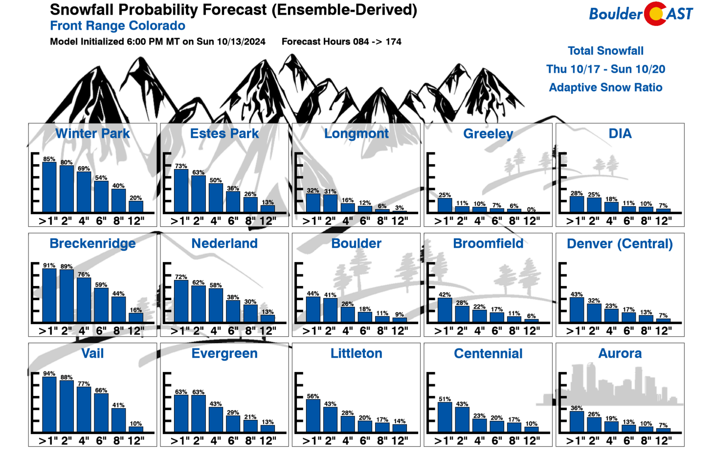
Looking at our latest Snowfall Probabilities, you’ll see the chances of at least an inch of snow or more for Denver and Boulder is about 40%. Keep in mind, however, this is gleaned off the GEFS, and thus will be biased toward the current worst-case scenario.
Let’s hope for some precipitation to help with the drought later this week. And for those snow bunnies, a little hope couldn’t hurt either — even though lower-elevation accumulating snow looks like a pie in the sky right now! Stay tuned — we’ll be sure to keep you abreast of any changes as the week progresses and more unsettled weather queues for the weekend. Enjoy!
Forecast Specifics:
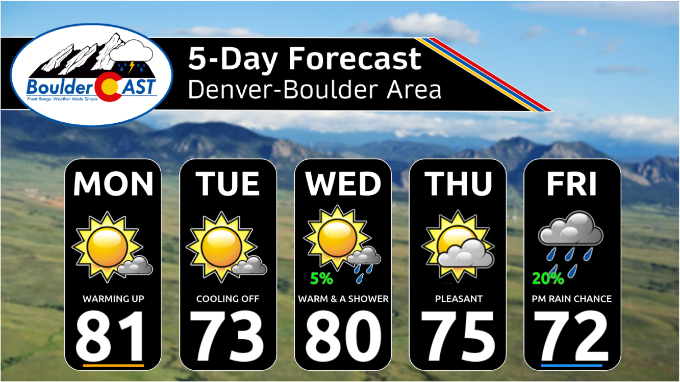
Monday: Mostly sunny with a few late-day clouds with highs in the lower 80s on the Plains and lower 70s in the Foothills.
Tuesday: Lots of sun with temperatures back to the low to mid 70s for the Front Range and middle 60s over the Foothills.
Wednesday and Thursday: Mostly sunny and quite mild with temperatures in the middle 70s to lower 80s on the Plains. Highs in the Foothills in the 60s. Thursday will have gusty winds, especially east of Denver, and fire danger will be elevated to critical.
Friday: Wide uncertainty in potential weather. Expect a chance of rain late in the day, with highs likely trending downward, near the 70s over the Front Range and 60s in the Foothills.
Weekend: Turning cooler with a chance of rain and/or snow. The best chance of snow will be in the Foothills and the Mountains, but we cannot rule out some minor accumulations in the Boulder-Denver area yet.
Get BoulderCAST updates delivered to your inbox:
DISCLAIMER: This weekly outlook forecast is created Monday morning and covers the entire upcoming week. Accuracy will decrease as the week progresses as this post is NOT updated. To receive daily updated forecasts from our team, among many other perks, subscribe to BoulderCAST Premium.
Go Premium, get all the perks.
Daily Forecast Updates
Get our daily forecast discussion every morning delivered to your inbox.
All Our Model Data
Access to all our Colorado-centric high-resolution weather model graphics. Seriously — every one!
Ski & Hiking Forecasts
6-day forecasts for all the Colorado ski resorts, plus more than 120 hiking trails, including every 14er.
Smoke Forecasts
Wildfire smoke concentration predictions up to 72 hours into the future.
Exclusive Content
Weekend outlooks every Thursday, bonus storm updates, historical data and much more!
No Advertisements
Enjoy ad-free viewing on the entire site.
Enjoy our content? Give it a share!


You must be logged in to post a comment.