After a mostly quiet and warm weekend, things will more-or-less remain unchanged for the first full week of June. Temperatures will stay warm to hot with only a small chance of rainfall this week. We’ve managed to dodge the nineties so far in 2024, but that bout of good fortune will run out later this week with multiple days soaring above 90 degrees. Read on for all the details.
This week’s highlights include:
- Fitting Right in With Climatology: This week will feature mostly dry and hot weather — very typical conditions for June in the Front Range
- Weak System Monday Night: A trough passing along the Canadian Border will provide weak forcing for a few spotty rain showers Monday night into early Tuesday morning
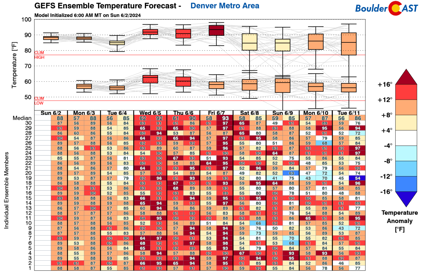
- Hot Mid to Late Week: A big ridge over the West will allow our temperatures to soar into the 90s for the first time in 2024. Wednesday will begin the hot stretch with several more days of 90s to follow.
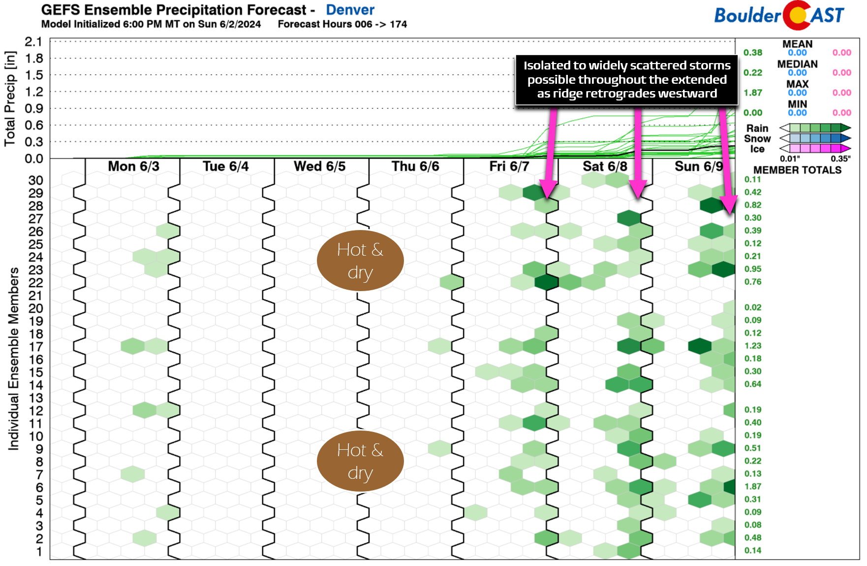
- Storm Chances Return for the Upcoming Weekend: Rain chances will return late Friday into the weekend as a slightly more active pattern replaces the hot ridge. Temperatures also cool back into the 80s.
DISCLAIMER: This weekly outlook forecast is created Monday morning and covers the entire upcoming week. Accuracy will decrease as the week progresses as this post is NOT updated. To receive daily updated forecasts from our team, among many other perks, subscribe to BoulderCAST Premium.

Go Premium, get all the perks.
Daily Forecast Updates
Get our daily forecast discussion every morning delivered to your inbox.
All Our Model Data
Access to all our Colorado-centric high-resolution weather model graphics. Seriously — every one!
Ski & Hiking Forecasts
6-day forecasts for all the Colorado ski resorts, plus more than 120 hiking trails, including every 14er.
Smoke Forecasts
Wildfire smoke concentration predictions up to 72 hours into the future.
Exclusive Content
Weekend outlooks every Thursday, bonus storm updates, historical data and much more!
No Advertisements
Enjoy ad-free viewing on the entire site.
An early taste of summer this week!
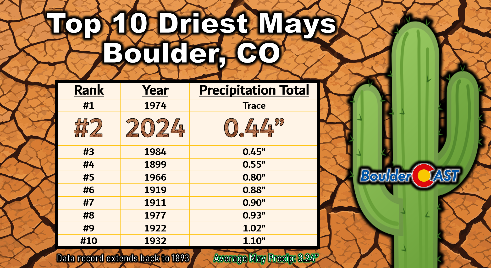
Despite having fifteen days with observed raindrops in the city, May 2024 concluded as one of Boulder’s most disappointing, accumulating just 0.44″ of rainfall (and no snow). May is typically our wettest month of the year, averaging 3.24″ of precipitation — so this shortcoming is a big deal hydrologically. This past May’s pathetic precipitation performance was good enough to notch second driest all-time dating back to the late 1800s. More historical context for the abnormal month of May can be found in our recently-published May 2024 Graphical Weather Review.
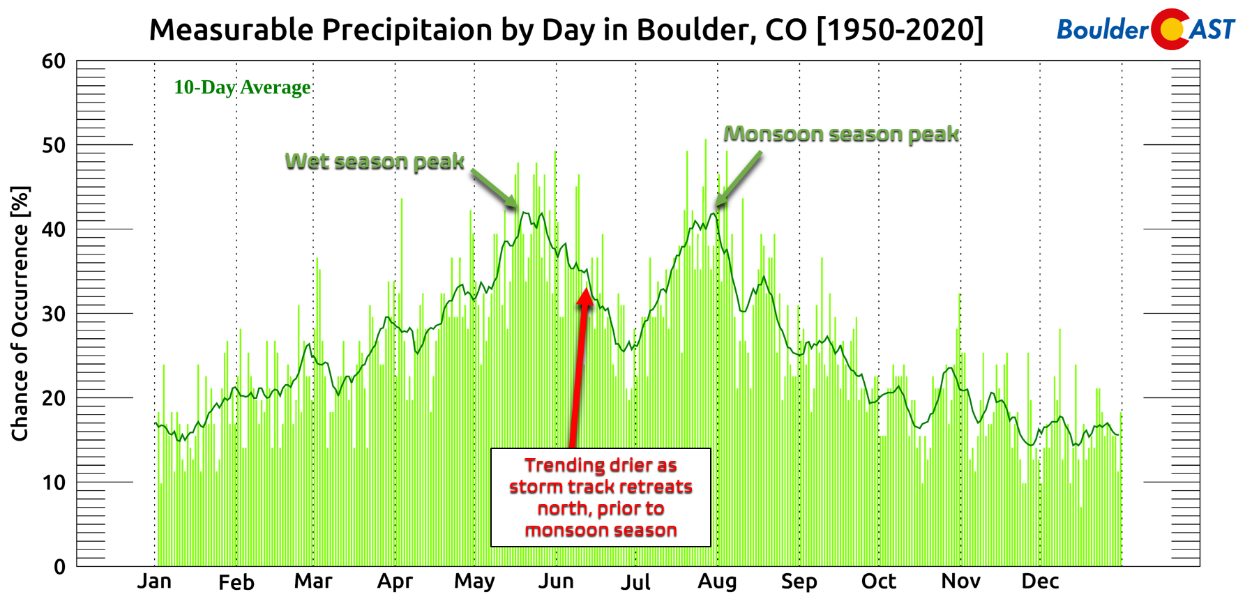
Unfortunately, the month of June is one where precipitation chances typically decline in the Front Range as the primary storm track retreats northward into Canada and we await the arrival of the summer monsoon in July. Will this climatological trend hold true for the first full week of June? Yes — yes it will.
We begin the week with partly cloudy skies and dry zonal flow over the Front Range as of Monday morning. Things are quiet for the time being, as seen in the GOES-East water vapor animation below, but just upstream across the Pacific Northwest the next shortwave disturbance is getting ready to come ashore. Ahead of this system, an expansive pipeline of mid- and high-level moisture is streaming into the northern Rockies producing a swath of elevated cloud cover — these clouds will reach our area around midday or so with clouds on the increase through our Monday.
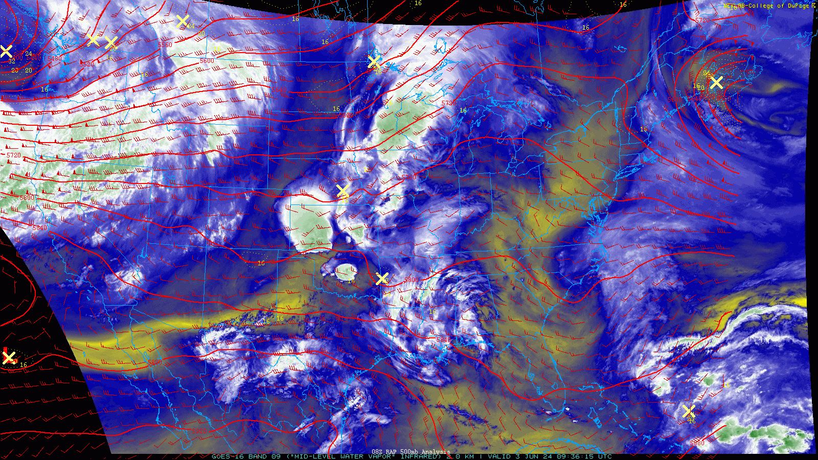
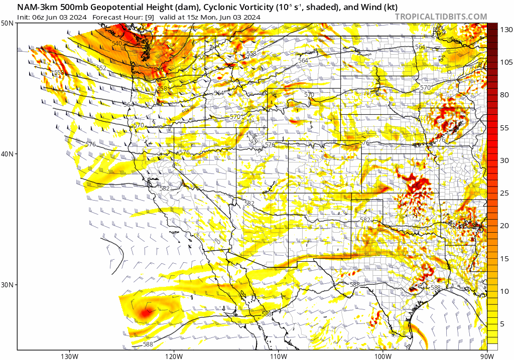
The aforementioned low pressure system will slide east along the US-Canadian Border throughout Monday into Tuesday, with a weak trailing trough axis sagging southward into Colorado (see below). This approaching trough will bring minor synoptic lift to our area Monday evening and eventually a cold front, allowing for a few showers to form across northern Colorado. Nothing major, but some of us may see brief light rain Monday evening into early Tuesday morning.
The incoming shortwave will spread southwest flow and warm air across the area on Monday, but the substantial increase in clouds will offset some of that warm air advection. High temperatures on Monday will definitely be up there, but most of us probably come up just shy of reaching 90 degrees. Pockets of morning sun will trend towards thicker high clouds as the day wears on.
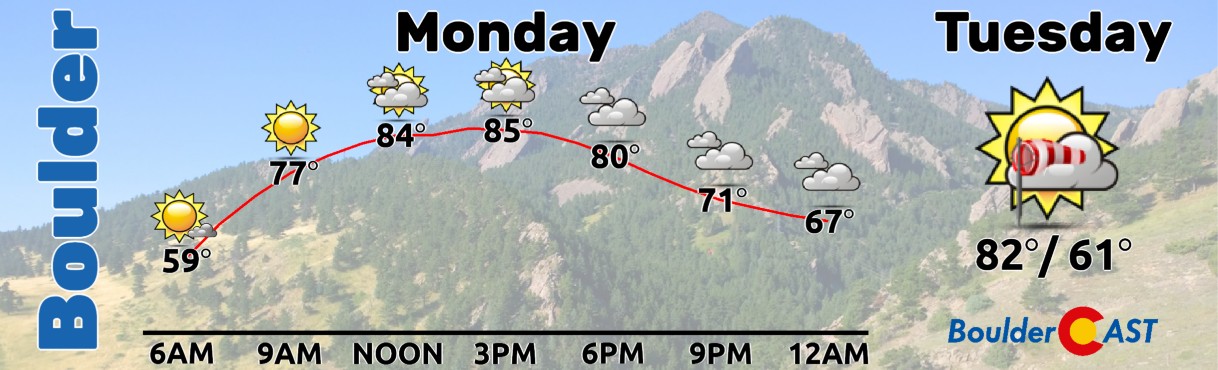
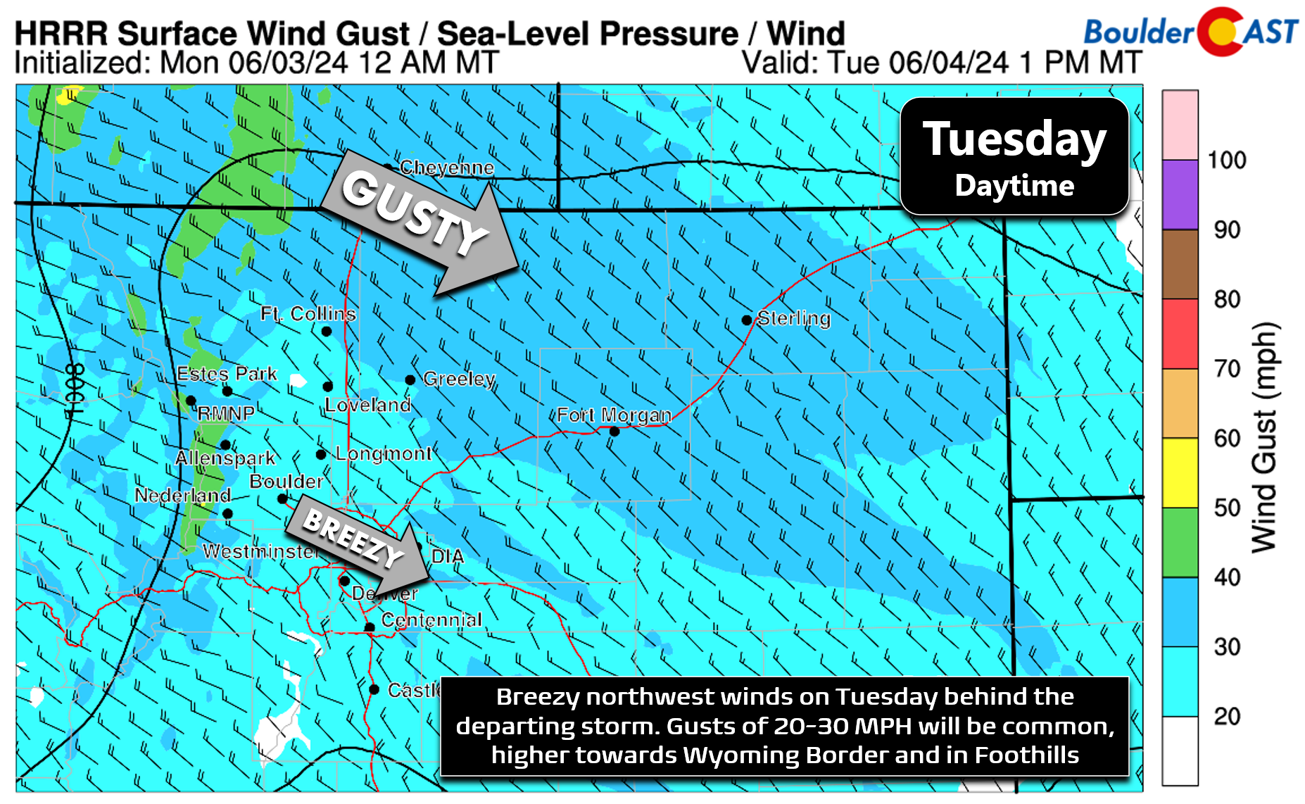
The early week storm system will depart Colorado Tuesday morning leaving behind subsident and dry northwest flow. As daytime mixing kicks in, gusty winds will come down to the surface from late morning into the early evening on Tuesday with gusts of 20 to 30 MPH across the Metro area from the northwest. Winds will be stronger in the higher Foothills and up along the Wyoming Border. High temperatures on Tuesday will be somewhat cooler in the low to middle 80s with decreasing clouds.
By midweek, the next major weather feature will be taking shape across the Four Corners in the form of a broad ridge of high pressure. The axis of this ridge begins over the Great Basin on Wednesday, slides eastward towards Colorado by Friday, then eventually retrogrades westward again for the weekend.
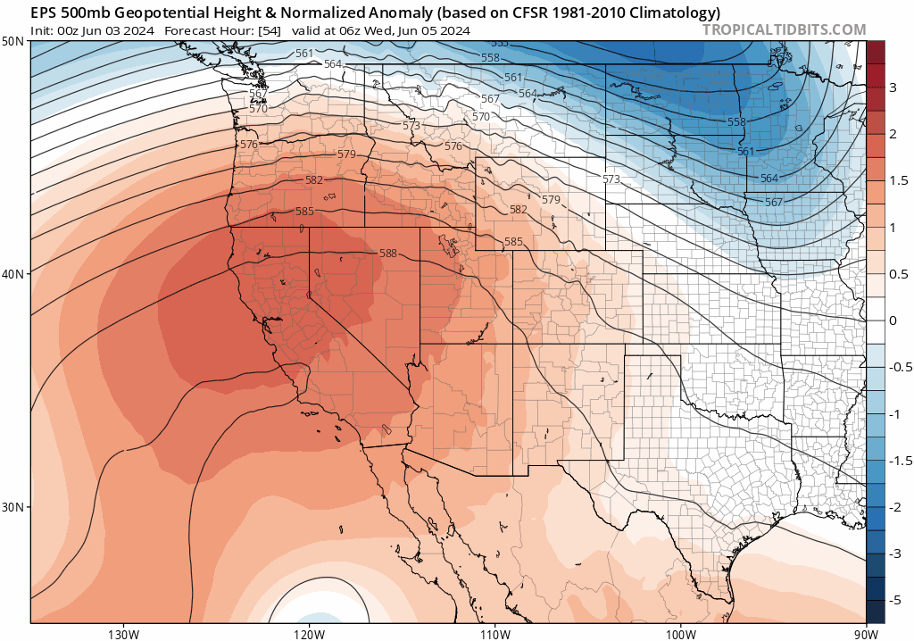
This ridge will lead to toasty temperatures through the mid- to late week period with high temperatures likely to reach the lower 90s Wednesday and Thursday, with perhaps middle 90s by Friday. Fortunately, this setup will also put a pause on the recent string of severe weather in eastern Colorado. If you didn’t hear, last week’s baseball-sized hailstorm is likely to land as yet another billion-dollar disaster for the Denver Metro area.
After a mostly dry week ahead, the big ridge will retrograde back westward for the upcoming weekend leading to increasing chances for backdoor cold fronts to encroach and a return of late-day storms, with our next chance of rain coming as early as Friday.
Enjoy the week — it sure will offer the summer feels!
Get BoulderCAST updates delivered to your inbox:
Forecast Specifics:
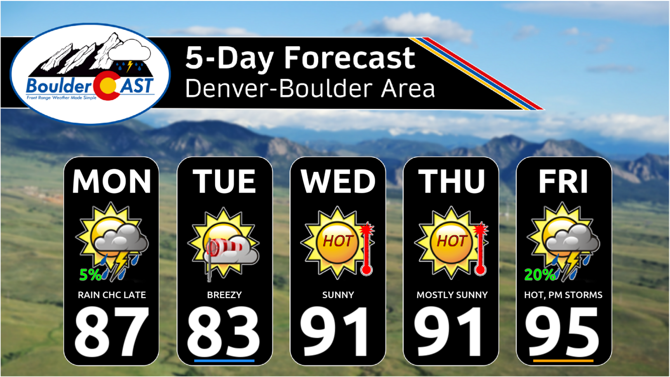
Monday: Partly sunny skies in the morning, but clouds thicken after midday. Dry conditions prevail until evening when widely scattered showers/storms may impact the area. The slight chance of rain will continue through the overnight. Highs in the upper 80s on the Plains with middle 70s in the Foothills.
Tuesday: Possibly a few early morning rain showers, then decreasing clouds through the day. Breezy with northwesterly gusts of 20-25 MPH. Highs cooler in the lower 80s on the Plains with upper 60s in the Foothills.
Wednesday: Sunny, hot and no chance of rain. Temperatures warm into the lower 90s on the Plains with upper 70s in the Foothills.
Thursday: Mostly sunny with just a few late-day clouds. There could be a storm or two south of Denver, but most everyone remains dry. High temperatures once again reach the lower 90s on the Plains with near 80 in the Foothills.
Friday: Morning sun gives way to increasing late-day clouds and a slight chance of thunderstorms. Depending on how the clouds and rain evolve, we likely heat up further into the middle 90s on the Plains with lower 80s in the Foothills. It could be cooler if clouds/rain are earlier and/or more extensive.
Weekend: The pattern stays somewhat active with continued late-day chances for showers and storms, though widely scattered coverage is expected. Highs both Saturday and Sunday should be pleasant in the 80s.
DISCLAIMER: This weekly outlook forecast is created Monday morning and covers the entire upcoming week. Accuracy will decrease as the week progresses as this post is NOT updated. To receive daily updated forecasts from our team, among many other perks, subscribe to BoulderCAST Premium.
Go Premium, get all the perks.
Daily Forecast Updates
Get our daily forecast discussion every morning delivered to your inbox.
All Our Model Data
Access to all our Colorado-centric high-resolution weather model graphics. Seriously — every one!
Ski & Hiking Forecasts
6-day forecasts for all the Colorado ski resorts, plus more than 120 hiking trails, including every 14er.
Smoke Forecasts
Wildfire smoke concentration predictions up to 72 hours into the future.
Exclusive Content
Weekend outlooks every Thursday, bonus storm updates, historical data and much more!
No Advertisements
Enjoy ad-free viewing on the entire site.
Enjoy our content? Give it a share!


You must be logged in to post a comment.