We hope you had a great Fourth! The Southwest monsoon remains active through the middle part of the week with good chances for rain in Boulder and Denver, especially Tuesday and Wednesday. Unfortunately, the pattern shifts late in the week suppressing the flow of monsoon moisture into Colorado. This will cause drying for us, but also a spike into triple-digit temperatures for the weekend. Read on for our full outlook of the week and weekend ahead.
This week’s highlights include:
- Lots of convective activity occurred on July 4th, but ultimately it didn’t create much disruption to holiday festivities across the Denver Metro area
- Monsoonal flow will keep the threat of rain around through Thursday alongside slightly cooler temperatures — best storm chances are Tuesday and Wednesday
- The pattern shifts Friday and into the upcoming weekend with a ridge developing over New Mexico
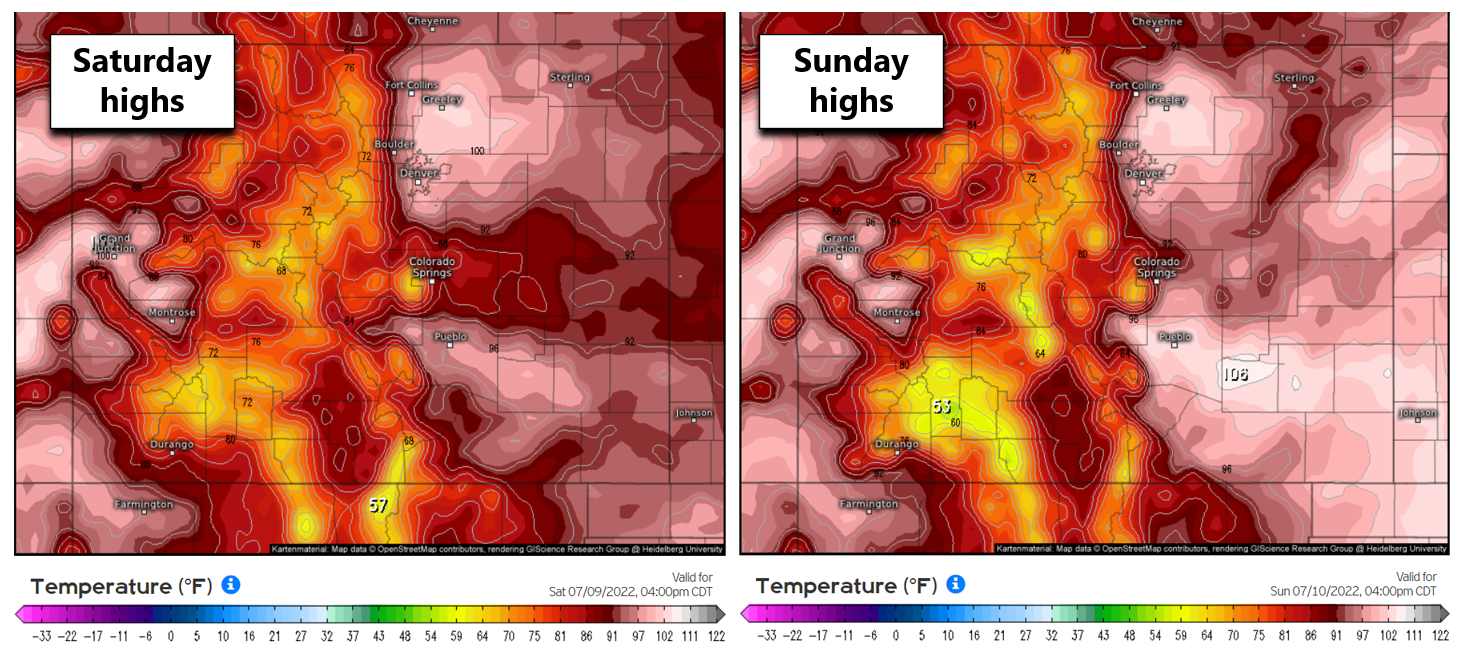
- Hot and mostly dry weather for Saturday and Sunday with temperatures soaring into the low 100s
- The heatwave should be short-lived with a cold front planned around Monday of next week
DISCLAIMER: This weekly outlook forecast is created Monday morning and covers the entire upcoming week. Accuracy will decrease as the week progresses as this post is NOT updated. To receive daily updated forecasts from our team, among many other perks, subscribe to BoulderCAST Premium.
The monsoon remains active through Thursday
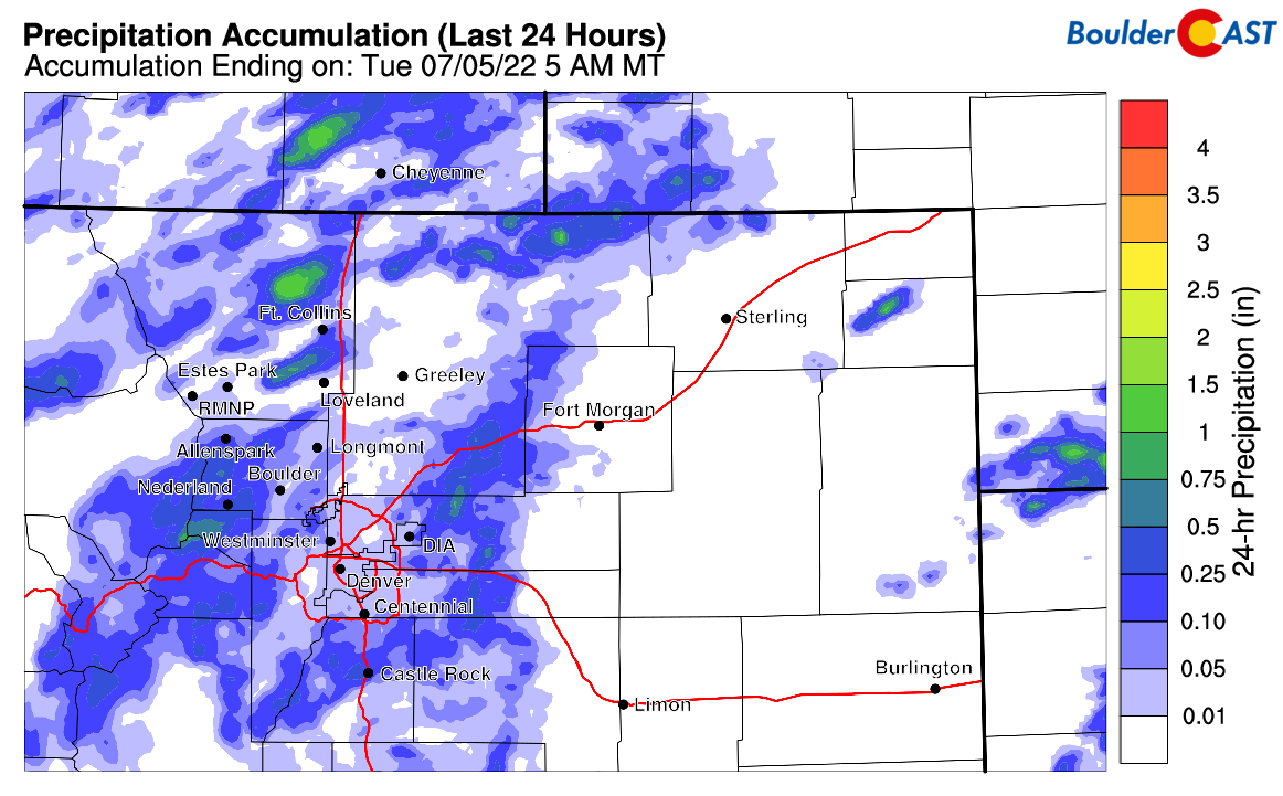
We hope you had an enjoyable Independence Day weekend. Though monsoon thunderstorms were around each day, it shouldn’t have caused any major disruptions to your outdoor plans, unless you were in the Mountains and happened to catch a few soaking rain storms of which there were plenty. Most of the Metro area saw just light rain on Monday with a few rumbles of thunder mixed in. The graphic below shows radar-estimated precipitation totals from July 4th. We recorded just 0.01″ in Boulder.
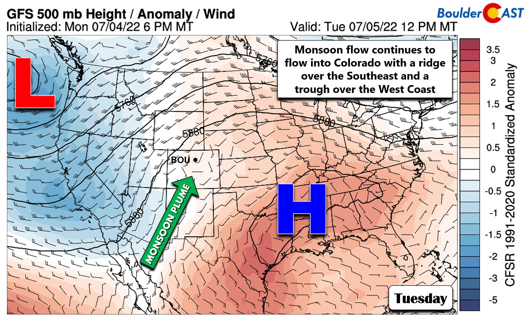
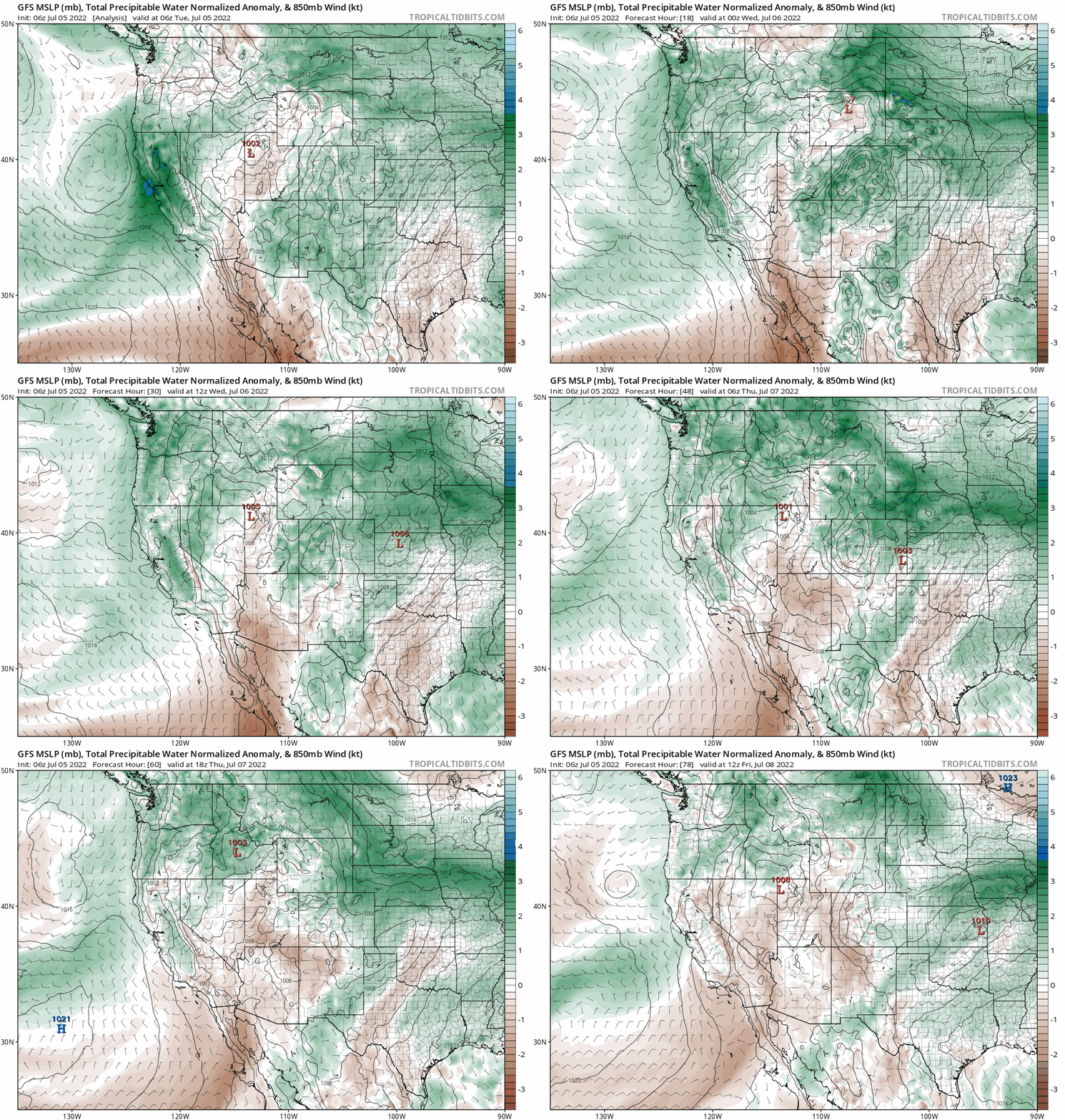
The same large-scale weather pattern across the United States responsible for the storm chances of late will stick around and even intensity for the next few days. A strong ridge in the Southeast combined with a broad trough in the Pacific Northwest will continue to pump monsoon moisture northward into Colorado. There are no changes there.
The GFS forecast animation below highlights the flow of moisture northward into the Front Range through Thursday evening. Moisture will be highest around Denver on Tuesday before falling off a little bit on Wednesday and Thursday. It will still be juicy though so storm chances are not going anywhere just yet!
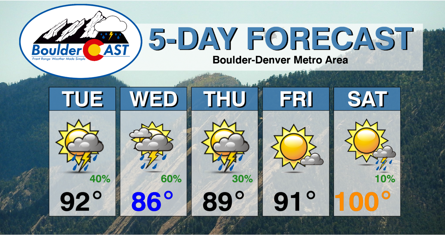
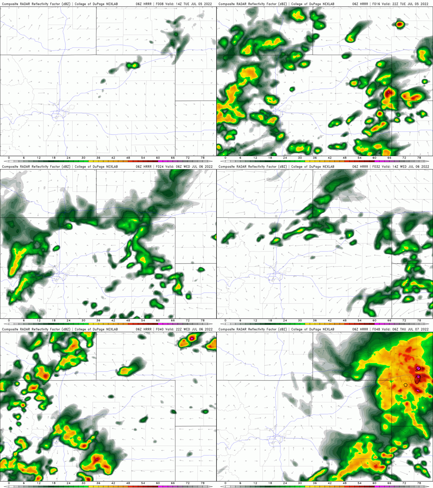
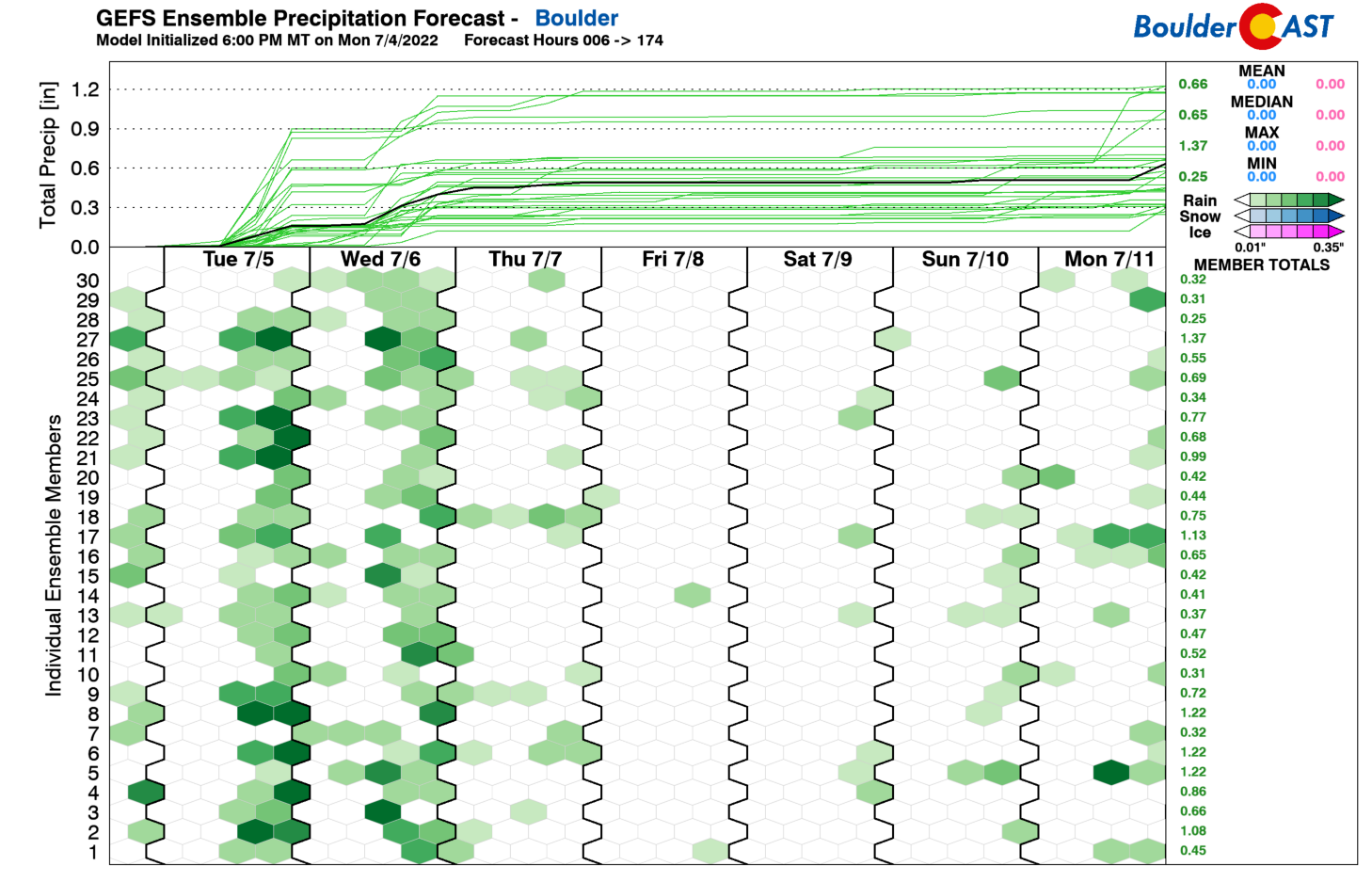
Both Tuesday and Wednesday will offer good chances of late-day thunderstorms in Boulder and Denver. You know the drill — sunshine early, clouds and storms building first over the higher terrain by early afternoon, then the storms march east into the Metro area by late afternoon and continue into the evening. This will be the story both Tuesday and Wednesday with scattered to widespread storms possible. Despite lower moisture content, Wednesday looks have some added lift generated from a passing shortwave. This should lead to a slightly higher chance of storms for the area compared to Tuesday. Check out the model-simulated radar animation below for the next 36 hours showing the storms bubbling up both Tuesday and Wednesday afternoons.
With the increase in rain chances and clouds, temperatures will cool off slightly for the midweek period with highs generally in the upper 80s to near 90 degrees both Tuesday and Wednesday.
Thursday will be similar overall, but the chance of rain will go down as the monsoon plume weakens and gets shunted to the east a bit. We’re still expecting another wave of late-day storms, but they will be more widely scattered in coverage.
There will be an outside chance of a few severe storms Wednesday and Thursday as low-level shear increases with easterly flow at the surface. The risk is mainly along and east of I-25. Thursday’s temperatures will be in the upper 80s.
The toasty weekend ahead
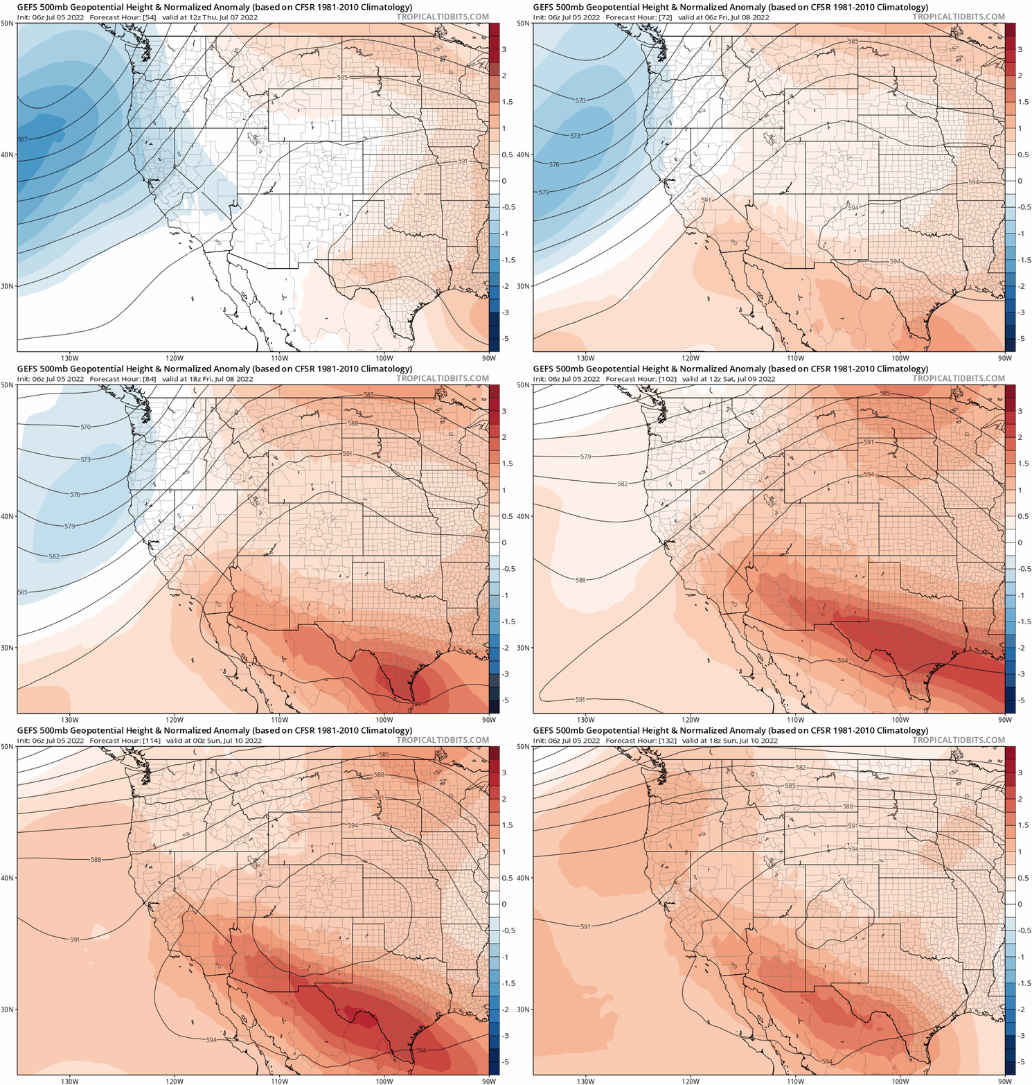
By Friday, the monsoon will be begin temporarily drying up across Colorado as the favorable pattern of late breaks down. The ridge that has been parked across the Southeast US will shift westward into Colorado and New Mexico. The GFS ensemble 500mb height anomaly animation below shows this transition. Once this new pattern takes hold of our area, the monsoon plume will get redirected westward into Arizona, Nevada and Utah causing drying for much of Colorado.
At the same time , temperatures will begin to soar statewide. Friday will only be the beginning with temperatures returning to the lower 90s. By Saturday and Sunday, we will likely be around 100 degrees in the Denver Metro area with only meager rainfall chances. The heatwave should last at least through Sunday, but a cold front is projected late Sunday or sometime Monday. Depending on the timing of this front currently six days out in the forecast, Monday could be another scorcher or somewhat cooler. Overall, long-range model guidance suggests this ridge pattern may stick over Nex Mexico through much of next week which would not bode well for seeing the monsoon rains return anytime soon.
Have a great week and plan accordingly for the very hot weekend ahead!
Stay up to date with Colorado weather and get notified of our latest forecasts and storm updates:
Forecast Specifics:
Tuesday: Morning sun, then increasing clouds with scattered afternoon and evening thunderstorms. Highs reach the lower 90s across the Plains with upper 70s in the Foothills.
Wednesday: Morning sunshine, then rapidly increasing clouds with scattered to widespread showers and thunderstorms possible. Some storms could turn severe east of I-25. Highs in the middle to upper 80s on the Plains with lower 70s in the Foothills.
Thursday: Increasing clouds with widely scattered late-day thunderstorms, some being severe east of Denver. Temperatures remain somewhat cooler in the upper 80s for the Plains with lower 70s in the Foothills.
Friday: Mostly sunny and likely dry with temperatures returning to the lower 90s across the Plains and into the middle 70s in the Foothills.
Saturday: Lots of sunshine with just isolated late-day thunderstorms. Very hot with near-record high temperatures possible. Highs around 100 degrees on the Plains with middle 80s in the Foothills.
High Country: Monsoon thunderstorms will be possible Tuesday through Thursday in the Mountains with heavy rain and lightning the main threats. Things begin to dry out and warm up by Friday with near-record warmth possible over the weekend ahead.
Help support our team of Front Range weather bloggers by joining BoulderCAST Premium. We talk Boulder and Denver weather every single day. Sign up now to get access to our daily forecast discussions each morning, complete six-day skiing and hiking forecasts powered by machine learning, first-class access to all our Colorado-centric high-resolution weather graphics, bonus storm updates and much more! Or not, we just appreciate your readership!
Spread the word, share the BoulderCAST forecast!






You must be logged in to post a comment.