As if we haven’t had our fill of winter already this week, another potent storm system will bring more accumulating snow to the Boulder and Denver area Wednesday night and into Thursday. This approaching storm isn’t as cold as the one earlier this week, but does have more moisture to work with and a very efficient mechanism to produce moderate to heavy snow. As a result, many locations will likely see more snow in the next 36 hours than what fell on Easter Sunday and Monday combined! Read on for a discussion of the incoming winter wonderland and a look at our snowfall forecast map.
PREMIUM STORM UPDATE (7:00 AM Thu 04/16/20): Heavy snow has fallen as expected overnight from Boulder to Fort Collins. We take a look at the latest model runs and discuss for the forecast for the second half of the snowstorm that will linger into Thursday evening. Click HERE to read.
Key Forecast Highlights:
- For the second (third?) time this week, a strong and cold storm system will spread snow across the Front Range
- Snow develops before midnight Wednesday night and continues into Thursday evening
- Snow could be heavy at times overnight into early Thursday morning
- Daytime highs on Thursday will range from 27 to 30 degrees
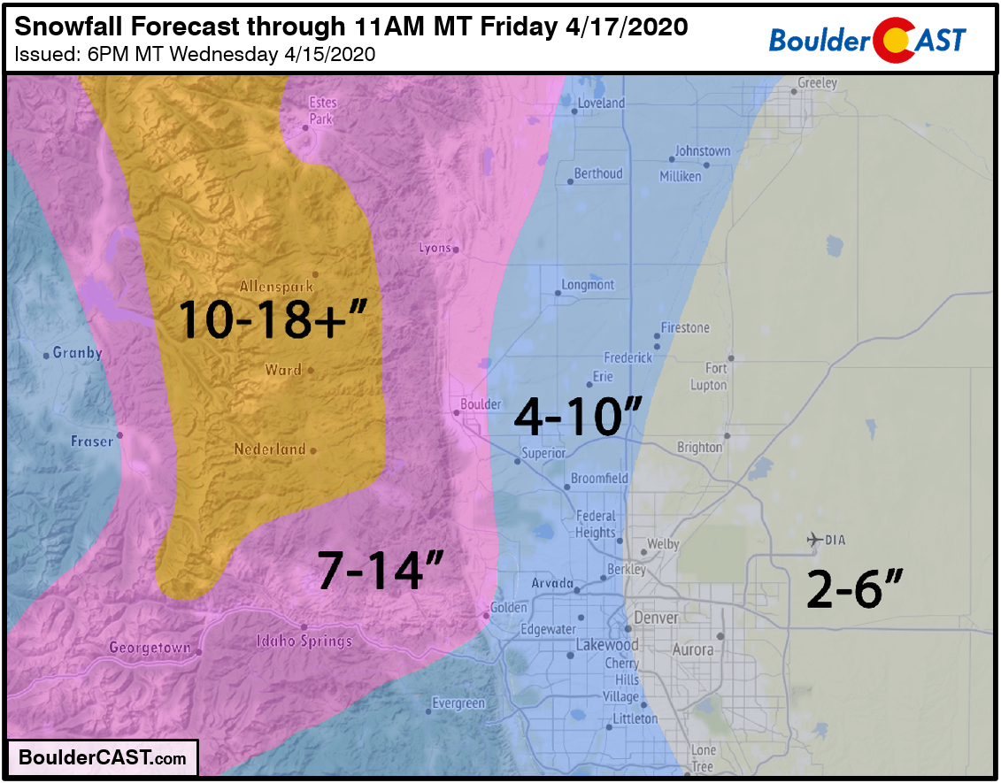
- Snowfall amounts will be heaviest in the Foothills and in Boulder, 7-18″; elsewhere, 2-6″ will be common
- Snow tapers off Thursday evening and night
Help support our team of Front Range forecasters by joining BoulderCAST Premium. We talk Boulder and Denver weather every single day. Sign up now to get access to our daily forecast discussions each morning, complete six-day skiing and hiking forecasts powered by machine learning, first-class access to all our Colorado-centric high-resolution weather graphics, bonus storm updates and much more! Or not, we just appreciate your readership!
T
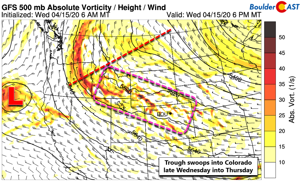
he incoming winter storm has shaken out a lot like the models were showing back on Monday when we posted our outlook for the week. We knew this was going to be a difficult forecast as the approach and track of the trough across Colorado are not typical and would be tricky to pinpoint. The 500mb height and vorticity forecast map from the GFS model below shows the conundrum we are facing. Notice the highly positive tilt to the trough axis stretching from Montana westward into Oregon.
Ahead of the trough, a long and skinny area of large-scale lift is present (outlined in pink). This lift is just beginning to reach northern Colorado as of 6:00 PM Wednesday evening. The problem is that as this area of narrow lift will move along with the flow but not waver much north or south. Track is much more important with tonight’s storm than others as there will be a somewhat tight swath of heavier snowfall with this system.
Further complicating matters is that co-located with the lift from the trough is an embedded polar jet streak. Northern Colorado will be passing in and out of various favorable quadrants for jet-forced heavy snow bands to develop throughout the duration of the storm. The best chance we believe for Boulder and Denver would be late Wednesday night into Thursday morning. The focus from high-resolution models tends to favor areas from Boulder to Cheyenne.
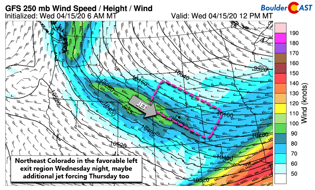
We’re already seeing radar signatures of jet-enhanced precipitation across southern Wyoming and far northern Colorado. The northern Metro area could see a few isolated rain showers through the evening as a result.
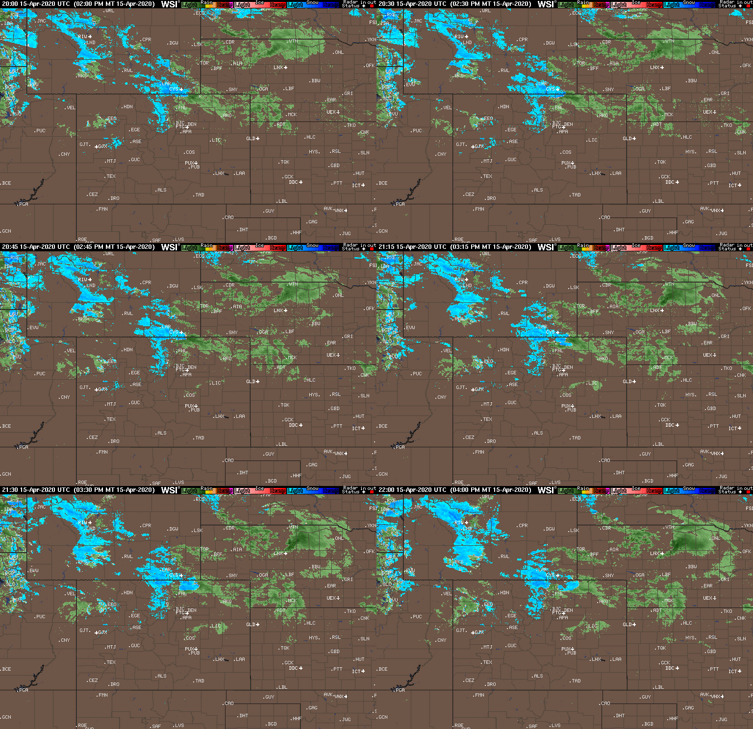
Strong frontogenesis and deep upslope will begin to spread precipitation southward across the Front Range through the evening, with overrunning moisture injected from the northwesterly flow aloft. This will be a VERY efficient precipitation mechanism for the region which lands the best forcing tonight! Heavy snow inbound!
The preliminary frontal boundary is just beginning to push into the northern Metro area as of 6:00 PM. The air north of the front isn’t that much colder, with Cheyenne and Fort Collins reporting temperatures in the upper 30’s to lower 40’s. However, the sun setting will help with additional cooling to turn any rain showers across the lower elevations to snow rather quickly. Snow could be very heavy following the change-over and through much of the overnight hours.
A secondary cold front will surge into the area early Thursday morning around sunrise or slightly before. This will usher in more gradual upslope but colder temperatures and gusty winds. The focus for snow will shift southward as northeasterly upslope favors Jefferson and Boulder Counties much more so than Larimer. Light to at times moderate snow will continue through the day Thursday and possibly into Thursday night if we play our cards just right.
Snowfall Amounts
Despite the uncertainty we’ve seen in the models over the last few days (and even this morning) regarding this system, they are coming into much better agreement now. That is with exception of the NAM model which is a meager outlier producing very little snow across the Front Range at the moment. Shown below are the latest liquid precipitation forecasts from the GFS, HRRR, and European models. The bullseye of heaviest precipitation, the lucky region we alluded to earlier, is shown to be the Foothills and nearby Plains of Larimer and Boulder Counties where between 1 and 1.5″ are on the table. This seems reasonable given the forcings at play. Further east and south, the rest of Denver area can expect between 0.25 and 0.75″.
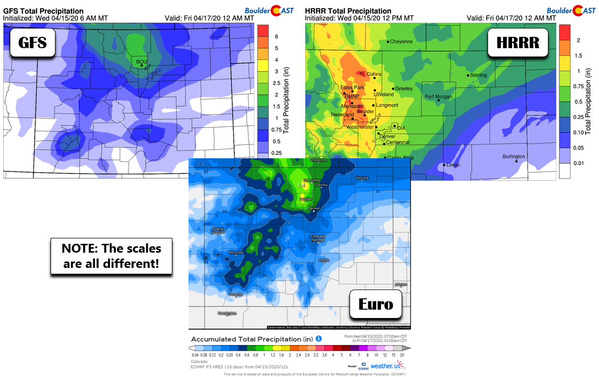
While snow ratios may not be as fluffy as we had earlier in the week, they should be respectable with much of the snow falling late tonight and into the morning Thursday with temperatures in the upper 20’s to lower 30’s. We’re thinking ratios of 13:1 across the lower elevations and 16:1 in the Foothills. This will surely equate to some impressive snow totals in Boulder and Larimer Counties!
Our snowfall forecast map for the event is shown below. This covers snow falling through Friday morning. Note that there will be a good deal of melting during the day Thursday, even though temperatures will be slightly below freezing. The mid-April sun is not to be contended with. With that said, the amount of snow on the ground will be less than what has actually fallen.
Timeline & Impacts
- The initial cold front moves through early Wednesday evening with gusty northeasterly winds and temperatures falling into the 30’s
- Isolated rain showers on the Plains this evening will become more widespread and change to snow quickly before midnight.
- Moderate to heavy snow will be possible much of the night, especially north and west of Denver. Boulder to Fort Collins should wake up to a winter wonderland on Thursday!
- As the second cold front pushes through the Metro area early Thursday, the storm shifts into more of a normal northeasterly upslope event with light to at times moderate snow lingering through most of the day into the evening. Accumulations during the middle of the day will be hampered by the mid-April sun, but additional light accumulations will be possible.
- Snow will taper off through the evening from north to south. The last snowflakes should end near the Foothills around midnight Thursday night.
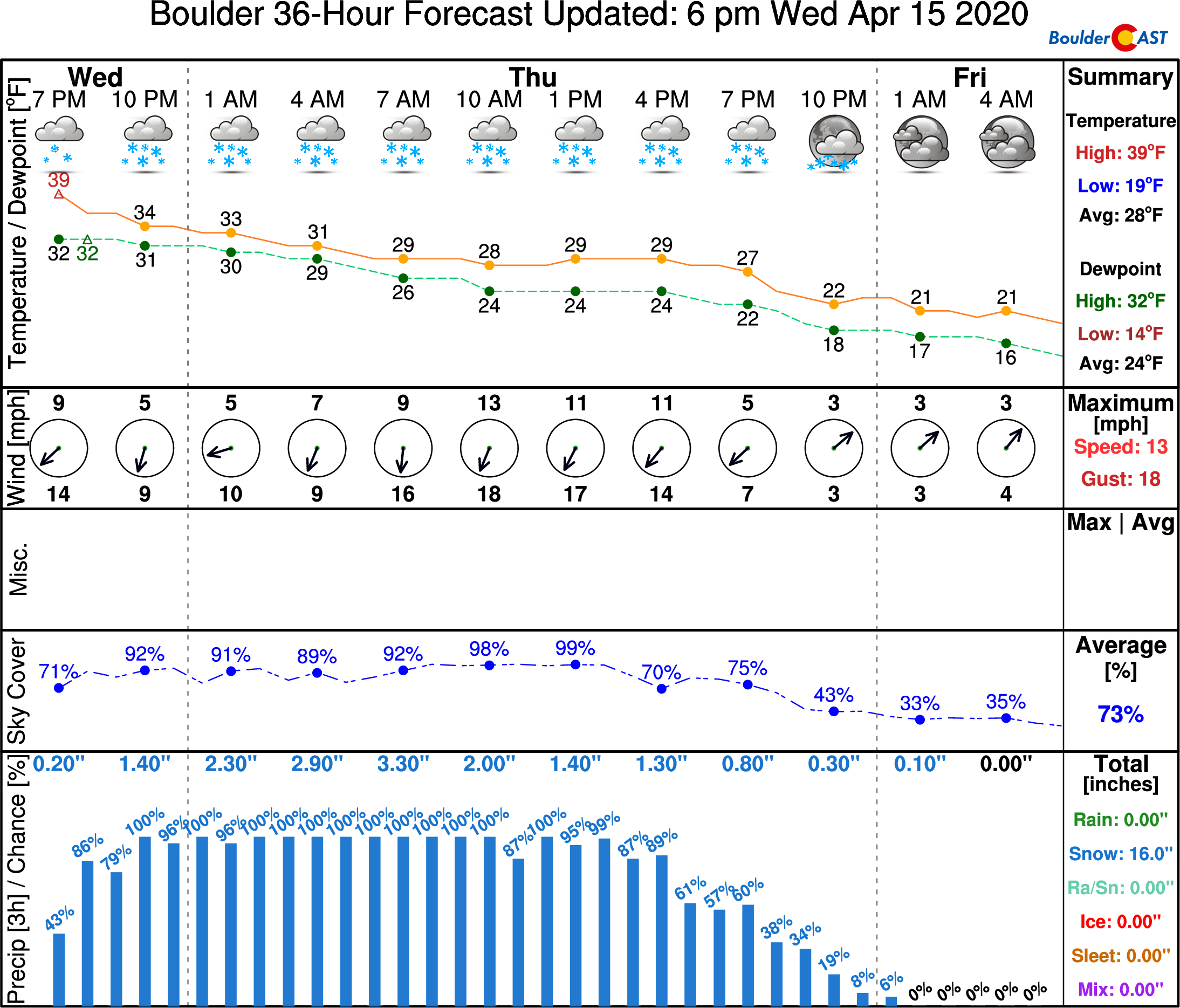
We dodged a bullet with the last snowstorm in that is was preceded by five consecutive days of 70+°F temperatures. Barely any of the snow that fell stuck on the sidewalks and roadways. And even if it did, it melted very quickly from the residual heat in the concrete/asphalt. This will not be so much the case with this storm. We should see snow stick much better overnight. Some of us may even need to bust out a snow shovel! For those making a commute Thursday morning, plan on icy and snow-packed roadways!
This likely won’t be our last snow of the season, but it could very well be the last significant one, so do get out and enjoy it if you can! And remember, Boulder only needs 8.8″ to set a new all-time seasonal snowfall record. Do a little snow dance, if you will!
Spread the word, share the BoulderCAST snow forecast!
.
Subscribe to receive email notifications for BoulderCAST updates:
We respect your privacy. You can unsubscribe at any time.
.




You must be logged in to post a comment.