It has been an extraordinarily warm winter thus far for much of United States, eastern Colorado included. The lack of extended cold has kept the surface of the Great Lakes largely ice-free so far, which is quite atypical. We discuss the implications this can have on regional weather and how it relates to our warming climate.
W
inter got off to a fast and furious start in Boulder this year! Thanks to a handful of autumn snow storms, Boulder surpassed 50″ of snowfall by November 27th, the second fastest in the city’s historical record dating back to the 1880’s. It seemed as though we may have been headed for a cold and snowy winter. However, since late November, Mother Nature has really let off the gas. Boulder has only received 4.0″ of snowfall since November 27th, and nothing at all yet in 2020.
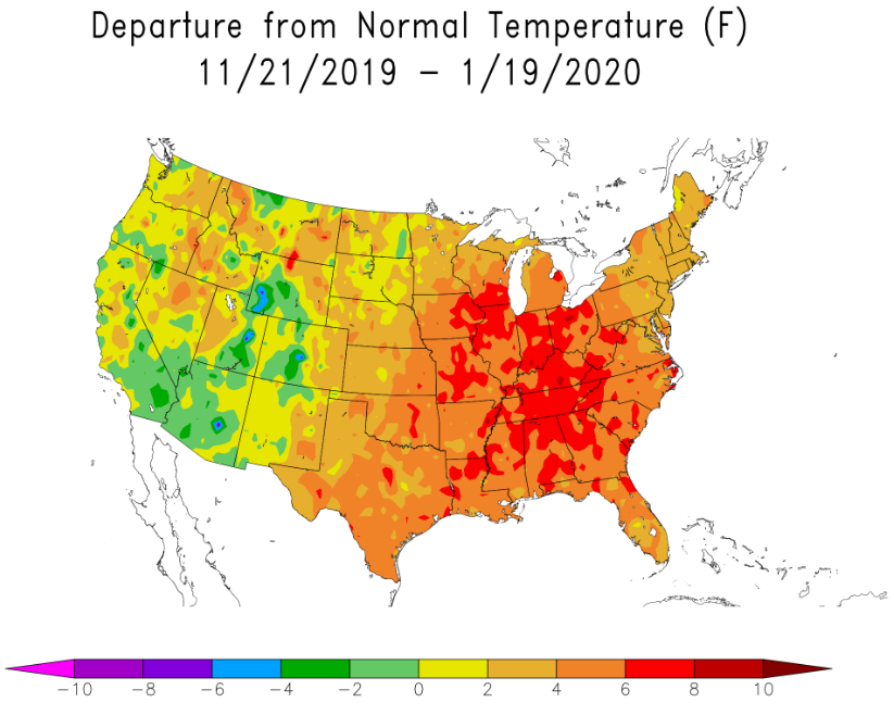
If you think the general warmth and recent lack of snow has been a bit concerning here in the Front Range, take a look at the graphic below showing temperature abnormalities over the last two months. A huge portion of the Mississippi and Ohio River Valleys have experienced mean temperatures between 4 and 7°F above normal during this timeframe. Many areas that are usually blanketed with deep snow this time of year have seen very little of the white stuff. My hometown in the mountains of southwestern Pennsylvania is a prime example of this.
In a typical winter, surface ice on the Great Lakes starts to form in late autumn and peaks around early March. Ice begins to form as soon as the entire depth of the lake cools to 32°F at a given location. Lake Erie is the shallowest and therefore usually the most iced-over of the lakes, despite being the furthest south. Erie’s average ice cover by early March is typically about 75%, but in colder years the shallow lake can easily freeze over completely.
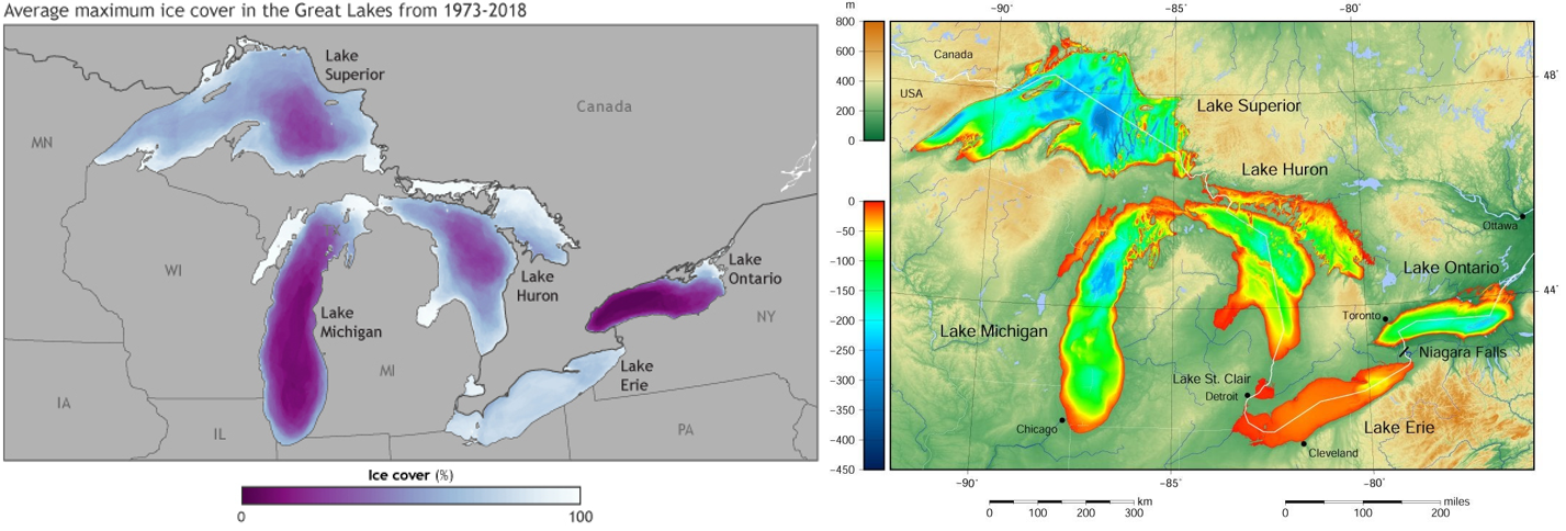
Average annual maximum ice cover since 1973 in the Great Lakes (left) and an elevation map of the area in meters (right)
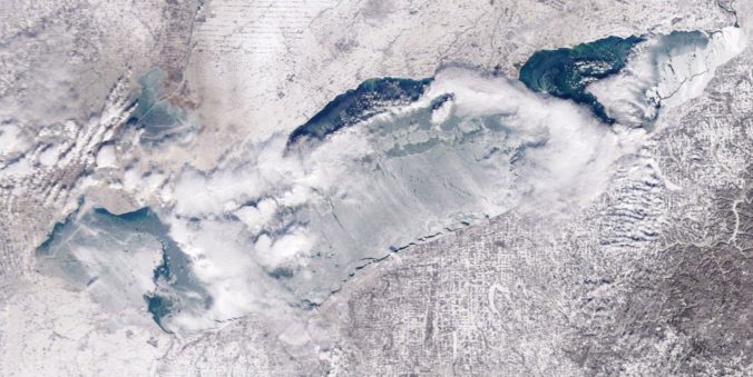
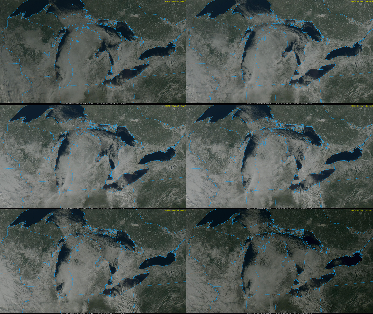
Shown below is the GOES-East visible satellite animation from Monday. It’s clear from the dark blue coloring of the Great Lakes that hardly any lake ice has formed so far this winter. This is not surprising since temperatures have been so warm for so long.
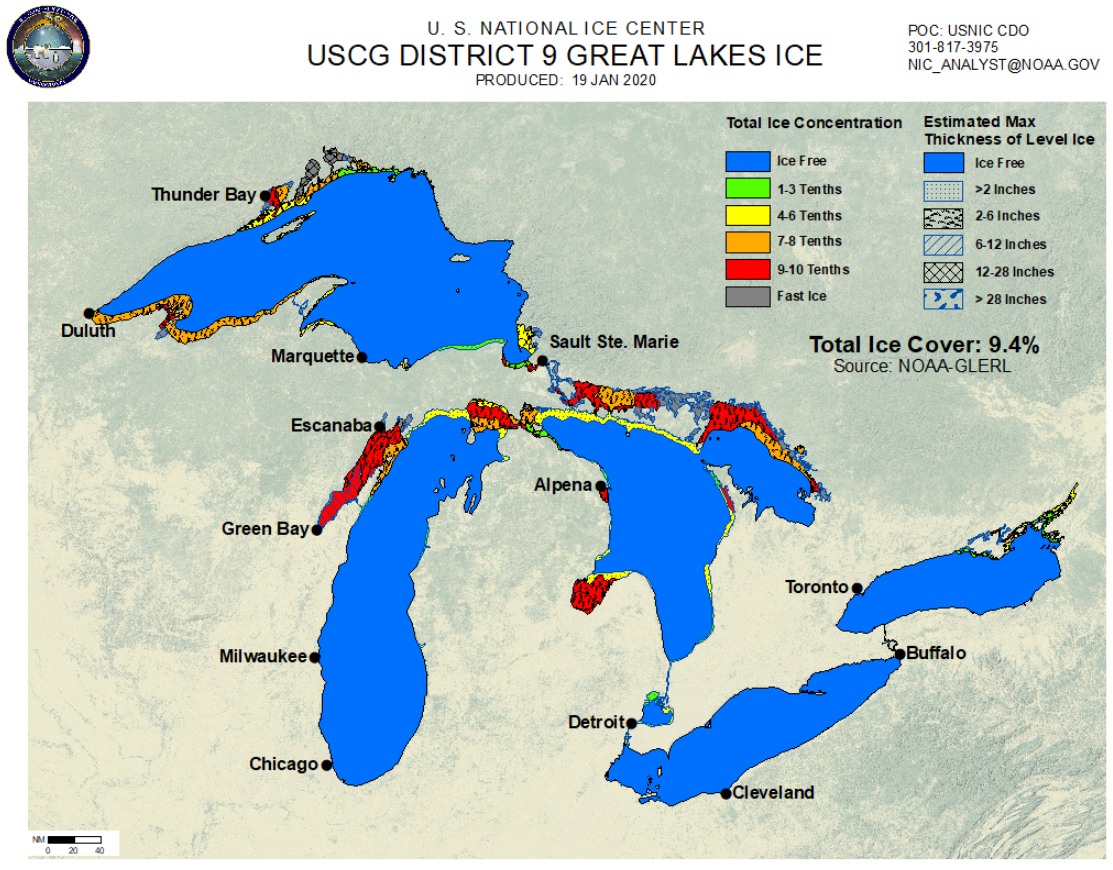
In fact, as of Sunday morning, just 9.4% of the Great Lakes were frozen over. This is less than half the value typical for this time of year and is one of the five lowest values ever measured on January 19th. Can you match the ice cover observations from the National Ice Center below with the satellite image above?
The lack of lake ice isn’t just a reality this winter. It’s something that has been occurring over the last 50+ years and is yet another easily observable indicator of climate change. Similar to Arctic sea ice, Great Lakes ice is declining, too. Maximum ice coverage was previously peaking near 70% annually across the entire Great Lakes in the 1970’s. Today that number is closer to 40%.
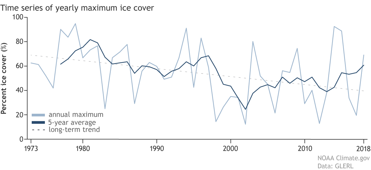
A time series of the annual maximum ice cover averaged over all of the Great Lakes from 1973 to 2018 showing the yearly data (in light blue), a five-year running average (dark blue), and the overall trend of the maximum ice cover data (dotted line). Source: NOAA
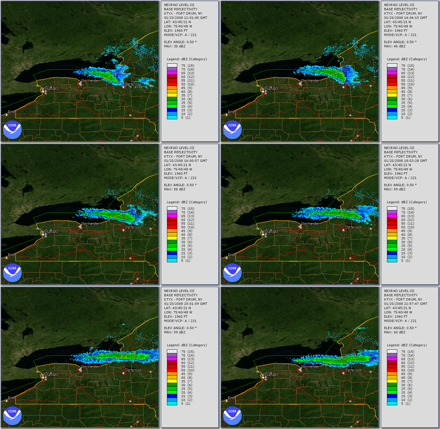
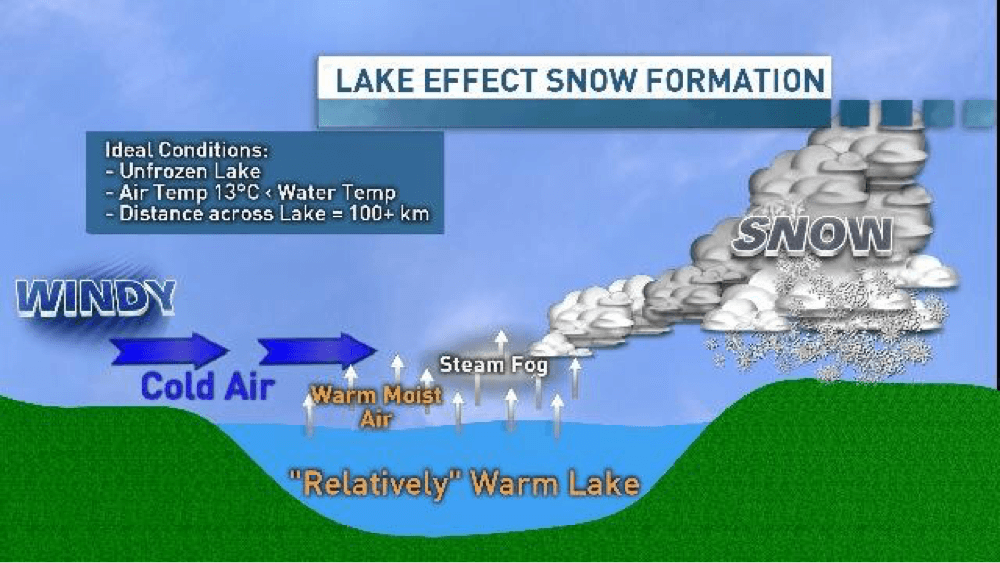
But why does a lack of lake ice matter? For communities downwind, the lakes provide a local source of moisture and more importantly, heat, as cold and dry Canadian air flows over the lakes. As the air picks up heat and moisture, it rises just downstream producing what are known as lake effect snow bands. An example of this from Lake Ontario is captured in the radar animation below.
Lake effect snowfall is commonplace in the Great Lakes, especially during the first half of winter before the lakes typically become partially or completely ice-covered. While a tiny amount of moisture can still escape through cracks in the ice, a frozen lake essentially kills the lake effect snow mechanism. In a bit of a paradox, warmer temperatures can actually lead to more lake effect snow (as long as the air remains cold enough for snow!). There has already been plenty of observational and modeling evidence to support this. However, it remains an active area of weather and climate research in the Great Lakes region.
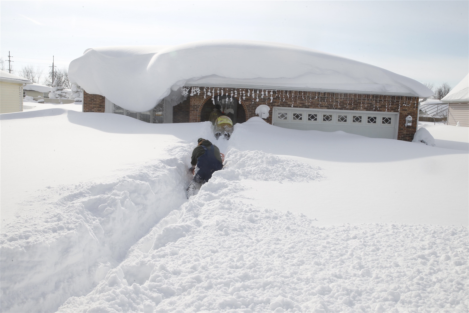
An extreme and recent example of lake effect snow occurred in Buffalo, New York back in November 2014. An early-season, slow-moving Arctic system produced ideal conditions for a prolonged period of heavy lake effect snow that persisted in a localized area for several days. The result was more than 6 feet of snow in an region just 25 miles wide. Thousands of motorists were left stranded, power outages were widespread, and many roofs collapsed on homes. 12 people lost their lives due to the fury of lake effect snowfall unleashed by Lake Erie that week.
NOAA also mentioned a few other important reasons to care about winter-time lake ice in a recent blog post:
- Shipping across the Great Lakes is a multi-billion dollar industry which employs tens of thousands of people. Every year freighters get stuck in the ice delaying deliveries and costing money.
- Ice cover also impacts the Great Lakes ecosystem and climate. Less lake ice means that more water evaporates from the surface of the lakes leading to lower lake levels. This has far reaching effects on the commercial shipping, fishing, and hydroelectric power industries.
- Many different ecosystems also rely on ice cover during the winter. Whitefish, for instance, use the ice cover to protect their eggs from big winter storms, which rile up the water. Making matters worse, if ice loss continues, cold-water fish like the whitefish might have to now compete with warm-water fish for the same resources.
Ultimately, whether or not the Great Lakes freeze over partially, completely, or not at all each winter has no impact on our weather in Colorado, but it is an interesting albeit depressing result of climate change nonetheless…
As a BoulderCAST email subscriber, you will get:
- Instant email notifications for all of our storm updates, forecasts, and posts
We respect your privacy. You can unsubscribe at any time.
.
Share this content:
.




You must be logged in to post a comment.