Ten years ago this week, torrential rains fell across the Front Range, triggering one of the worst floods in Colorado’s short recorded history, accompanied by a staggering repair bill now approaching $3 billion. With Boulder County at the epicenter of the disaster, the road to recovery has been long and arduous, and still continues today. We take a look back at this historic event, explain how it happened, and provide an update on related analysis performed since.
How it happened
The first week of September 2013 was hot. Very hot. After a week of 90+ degree days, two of which were record-breaking, Boulderites anticipated September 9th’s cold front passage more than ever. No one could have foreseen the prolonged deluge of rainfall that was about to commence.
An upper-level cut-off low pressure system was slowly churning over the Great Basin. Extremely moist air, unprecedented for September, was advecting northward from the eastern tropical Pacific Ocean and from the Gulf of Mexico, converging on the Front Range. Forecasters warned that much of the area could experience heavy rains over the next few days. Temperatures plummeted more than 30 degrees behind the associated front (aided by cooling from clouds/rain), from the mid 90s on the September 8th, to the low 60s on the 10th. As we have stressed many times before, cut-off lows are troublesome for forecasters. They are completely removed from the jet stream, with little forcing to move them along. Because of this, they often hover, meander, and slowly migrate in unpredictable ways.
Over one inch of combined rain fell on September 9th and 10th, an amount that is not all that common, nor truly rare for September in Colorado, especially for a cut-off system. However, this particular low was different, as it barely moved for five days.

500mb height map from the NCAR/NCEP reanalysis, showing the position of the cut-off low on Sep 11 and Sep 14. In three days, the low tracked just 300 miles, an average movement speed less than 5mph.
The near-stationary low pressure continued to pump monsoon moisture into Colorado.

Water vapor satellite imagery for Sept 11/12, showing the conveyor belt of moisture streaming into Colorado.
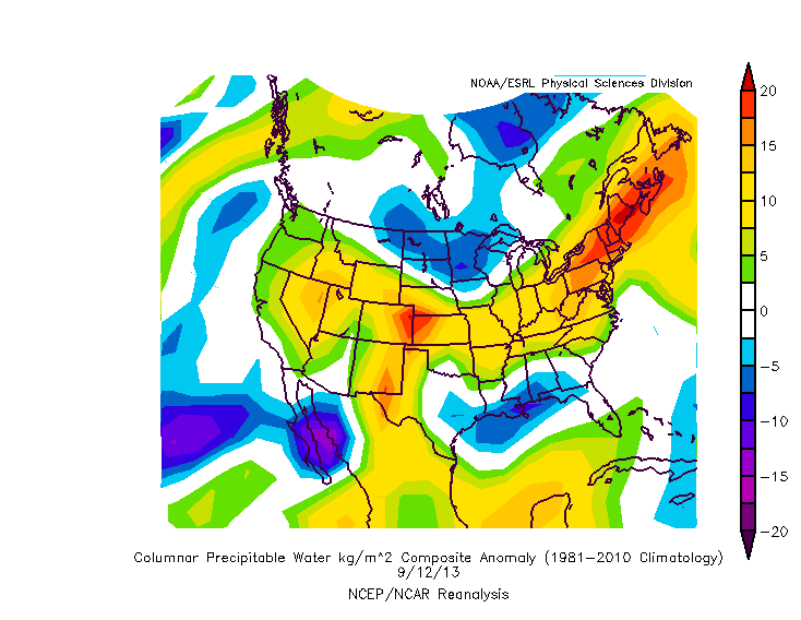
Shown below is the precipitable water (moisture) anomaly on the 12th. Notice the huge positive anomaly over eastern Colorado.
Do you wonder why the anomaly over Colorado had so much impact, relative to the even bigger and more intense anomaly over New England? The short answer is that moisture is only one component needed for torrential rain. In order to produce the clouds and rainfall, a mechanism is also needed to lift the moisture to cool the air. An associated 700 mb low pressure set up south of Colorado and provided the lift, via persistent and intense southeasterly low and mid-level upslope flow. This was further enhanced by the original frontal boundary, which stalled just south of Boulder County.
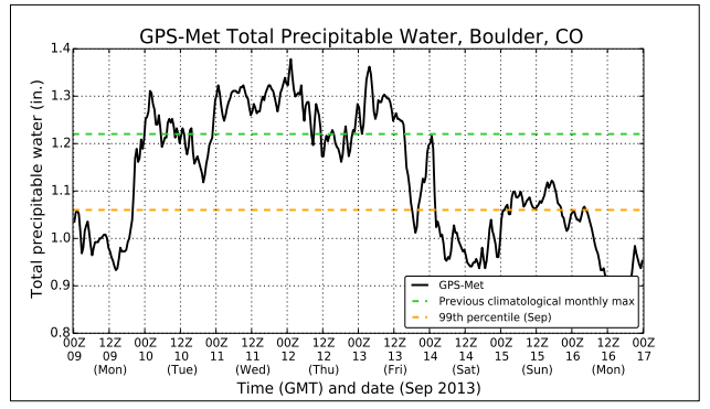
A time series of precipitable water for the duration of the event. The green line denotes the previous record moisture for the month of September. Moisture levels in Boulder were above the all-time max for almost four straight days!
The recipe for flooding was followed to a T…it truly was a “perfect storm.” The record-breaking moisture (see above), the stationary front, the stalled upper-level low, the topographic upslope. All the ingredients came together, and remained together, for a very long time.
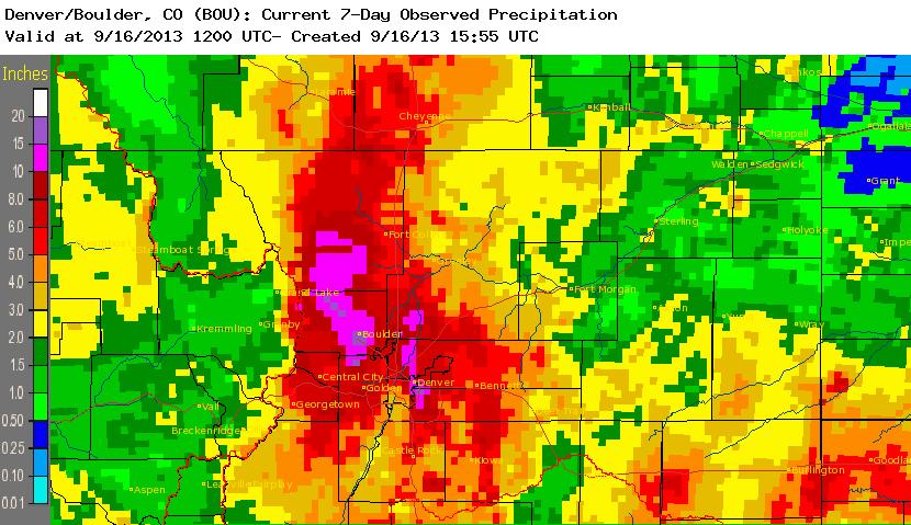
When it was all said and done, Boulder officially recorded 17.24″ of precipitation, nearly a year’s worth of rain, in just eight days. September 2013 went down as the wettest September and wettest month ever. The 9.08″ of rain that fell in the 24-hour period ending at 6 pm on September 12 was the wettest 24-hour period on record, nearly doubling the prior best. The 7-day rainfall record was also shattered.
How frequently does this happen?
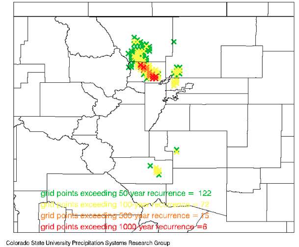
The rainfall totals were extreme, with scientists generally agreeing that this magnitude of rainfall over the observed time frame only occurs in the Front Range once every 100 to 1000 years. Shown below are the annual exceedance probabilities for various grid points across Colorado for this rainfall event (compliments of Colorado State University). For many areas, this was a 100-year event (shown in yellow), meaning in any given year, there is a 1 in 100 (1%) chance for a similar rain event to occur. In areas hit the hardest, like the city of Boulder and the mountains just west of Lyons, this was a 1000-year rainfall event (denoted in red below).
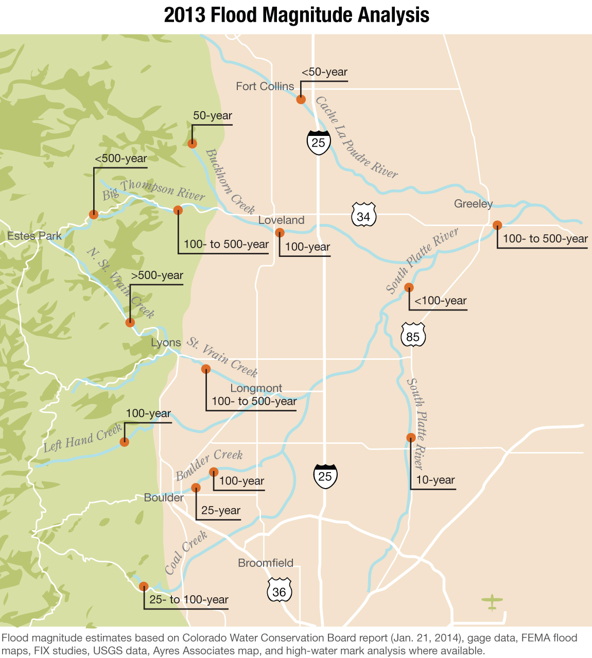
However, the extent of the flooding was not necessarily as extreme as the rainfall. The figure below shows the stream gauge analysis for the event, for various creeks/rivers across the Front Range. Due to the short observational record, these estimates are basically just frequencies spit out by atmospheric/hydrological models.
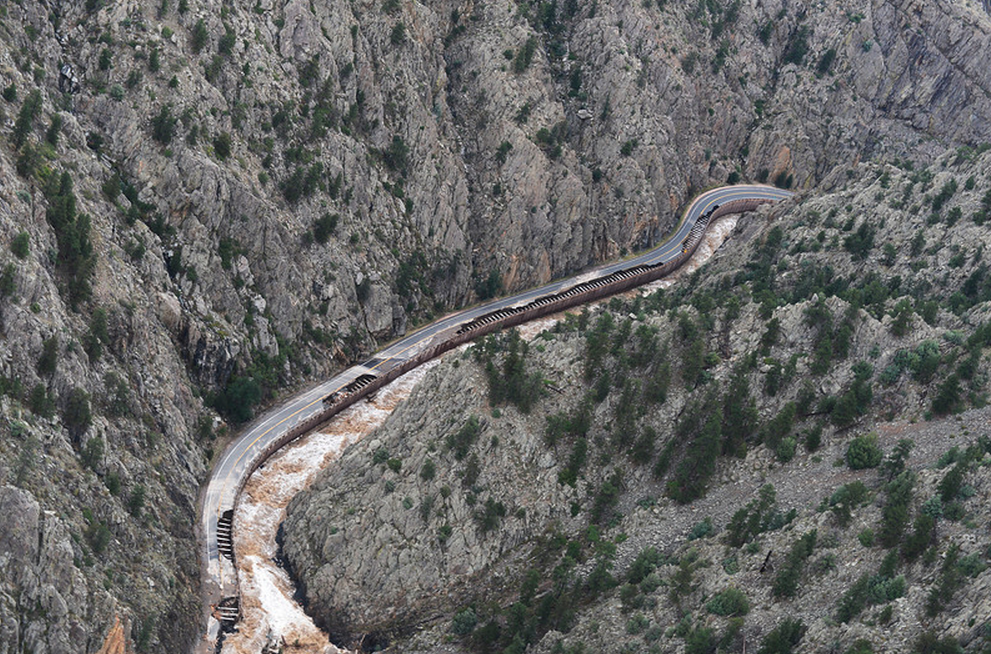
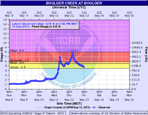
While Boulder may have received the most rainfall, the most significant and historic flooding was present in Lyons and Longmont, where a bulk of the rain fell upstream and was funneled by steep terrain through tight creek beds. For the Boulder Creek, it was less than a 50-year flood event, with stream flow peaking at an estimated 5200 cubic feet per second (c.f.s.), less than half the amount of the titanic 1894 Boulder flood. Keep in mind, the average mid-September stream flow for the Boulder Creek is only around 100 c.f.s.
The take-away: the event was without question historic, but it could have been worse for Boulder, because:
- The heaviest rain fell on the city itself, not upstream. This limited how much water actually came down Boulder Creek from the mountains.
- The long duration of the event also helped to limit the peak stream flow, spreading the deluge out over the course of seven days.
- The event’s occurrence at the end of the water year, with virtually no input from mountain snow melt, was fortunate as well.
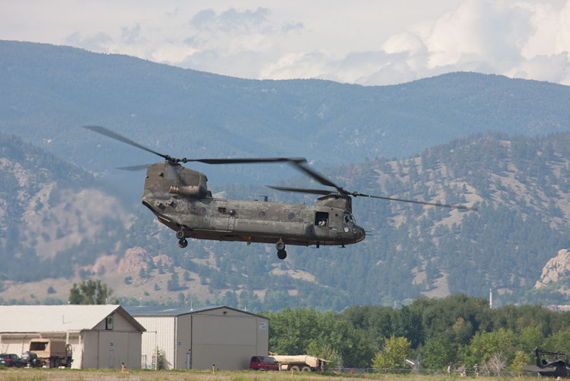
Chinook helicopter on-call to rescue trapped flood victims cut-off by destroyed Colorado roads | Boulder Airport
Ugh, What about climate change?
The concept that climate change may be altering the probability and intensity of extreme weather events is quite a hot topic in the atmospheric science world. Any event like the Boulder Flood is and will remain very rare, now and into the future, as the Earth continues to warm. Climate change cannot be definitively linked as a cause to this disaster, since the atmospheric dynamics that came together for this event cannot be determined to be more likely given climate change. Modeling subtle changes to the overall atmospheric circulation, like the pattern behind the Boulder Flood, is a massive challenge. Hypothetically, our best climate models may indicate that with climate change, the 1000-year flood is now becoming a 990-year flood. Unfortunately, most climate model uncertainties outweigh this small change, so it is considered indiscernible, as the change in re-occurrence rate can be explained solely by model uncertainty. While this is the case for the region surrounding Colorado, heavier rain events are becoming statistically more frequent on a national and global scale.
There are also other, indirect effects of climate change. For example, as our climate warms, the territory habitable for bark beetles expands. As they take over and kill our evergreens, forests become primed for wildfires. More wildfires, like the Flagstaff Fire and Fourmile Fire that occurred near Boulder in the last few years, ultimately contribute to flooding by increasing run-off. Furthermore, drought, exacerbated by a warming climate, also contributes to wildfires and overall less-permeable ground surfaces. Much of Colorado was in a moderate drought before the flood, which undoubtedly contributed to surface run-off, in the end, amplifying the flood extent.
There is one positive outcome: the flood reduced the areal drought extent in Colorado from 94% to just 20%. Not bad for just one week’s time!

Areal drought coverage of Colorado over the last 4 years. Drought shown in light orange, intensifying into deeper reds.
We discussed a more sound way to attribute climate change to actual extreme events in a recent podcast, including context for the 2013 Boulder Flood. Essentially, new approaches focus solely around tangible impacts of climate change, specifically those that a warming atmosphere and ocean can directly impact, like sea surface temperatures and atmospheric moisture content (remember, warmer air can “hold” more moisture). They ask: given the background atmospheric state, which would have likely occurred with or without climate change, how did the added warmth and moisture (directly resulting from climate change) contribute to the outcome? By altering those specific parameters in the models, the effect can be quantified. The Boulder Flood would have happened either way, but climate change likely made it slightly worse. Two years later, we don’t have all the answers, or even most of them. Scientific studies, techniques, and models will continue to evolve, improving our understanding of the Boulder Flood in the context of climate change in the years to come.
Learn, Evaluate & Adapt
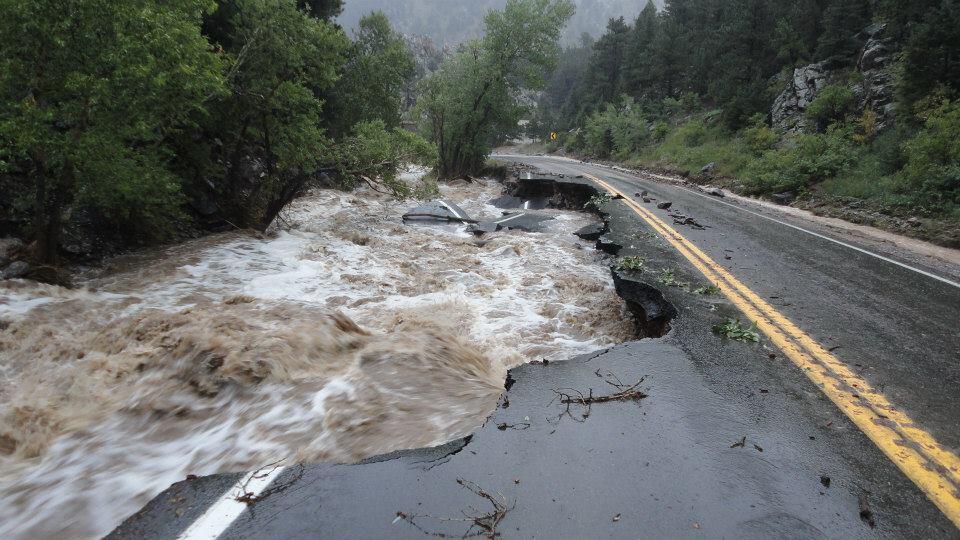
The September 2013 flood in the Front Range serves as a sobering reminder of the dangerous power of water, just as the 1939 Boulder and the 1976 Big Thompson Floods have done before. Our region has an inherent, natural vulnerability to flash flooding, whether it be within a highly localized thunderstorm in steep terrain, or slowly over a broad region like in 2013. Occurrences this extreme provide valuable data for tuning weather models to more accurately forecast them in the future. Eight people tragically lost their lives in the flood, most of which were in Boulder County. We need to do better. This event offers an opportunity to learn, evaluate, and adapt. With the population in the region continuing to explode and an estimated damage total for the flood nearing $3 billion, we can’t afford not to.
—
Do you have a story of the Boulder Flood you would like to share? We would all love to hear it. Post it in the comments below.
If you haven’t already done so, follow us on Twitter or Facebook for frequent weather updates and subscribe to the site to get these posts automatically delivered to your email box (enter your email in the sidebar widget to right). Also, be sure to check out our podcast!
Feature image credit: CIRES

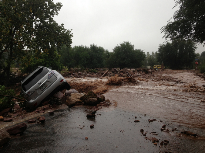



In another part of the state that saw this record rainfall, was a tiny section near the Aurora/Denver border in NW Arapaho County, where a year’s worth of precip fell in just a few days. Everyone in this neighborhood had basement flooding, and was eligible to apply for FEMA flood assistance.
Thanks for sharing Daisy! I know the spot, I was actually driving out to DIA that morning where it just dumped rain in a very narrow band in NE Denver! I hope we all never have to experience something like this again.
Thanks for sharing Daisy! I know the spot precisely. I was driving to DIA the morning (day) that you guys picked up 10-13″ of rain. It was insane!