Prolific snow and rain through the spring and early summer has painted an exceedingly green picture across eastern Colorado this year. Grasslands and meadows that are typically an ugly shade of brown by now are tinted in a vibrant emerald hue. As a result, there has barely been a single wildfire across the state this summer. We take a look to see just how extraordinary the amount and consistency of the precipitation in Boulder has been in 2015.
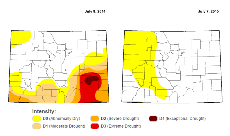
Drought is a thing of the past now in our state. Look at the difference just one year can make, especially for southeastern Colorado.
2015 has been exceptionally wet. Let’s start off by recapping the precipitation that occurred in each month to date so far in 2015 (all data from official Boulder NWS site):
- January: The month of normalcy
- 0.38″ precip (all of which was contained in 6.0″ of snow)
- Nothing remarkable about this month, slightly below average for precip
- February: The month of the white stuff
- 3.69″ of precip (all of which was contained in 54.6″ of snow….yes, 4 and 1/2 feet of snow!)
- Both snowfall and precip were all-time records for February
- Broke daily snowfall records on April 1st, 8th, 16th, 21st, 22nd, and 26th!
- March: The calm before the deluge
- A mostly dry month with above normal temperatures
- Ironically, also had 0.38″ of precip, most of which was snow, but also, some light rain
- Well below normal, which is 1.68″
- Set two record high temperatures on the 15th and 16th. In fact, the 16th was the earliest 80 degree day in Boulder on record
- April: The deluge before the deluge
- 4.50″ of precip, including 7.4″ of snowfall
- After two dry weeks to start the month, April went out very wet, with rain recorded on 14 of the last 15 days
- Ended as only the 16th wettest April on record
- May: The deluge
- 7.82″ of precipitation, almost all of which was rain
- 28 out of 31 days recorded precipitation
- After setting record for earliest 80-degree day on March 16, it was not until May 31 that Boulder surpassed 80 degrees for the second time in 2015
- 5th wettest May ever
- June: The drying period
- 1.76″ of precip, below the normal of 2.22″
- Wet first 10 days, then dry and hot for the last three weeks of June
- July: Only half a month of data
- In the first half of July, Boulder already has 2.24″ (BoulderCAST has measured 2.27″)
- All 14 days of July have had rain
- July average rainfall is 1.79″
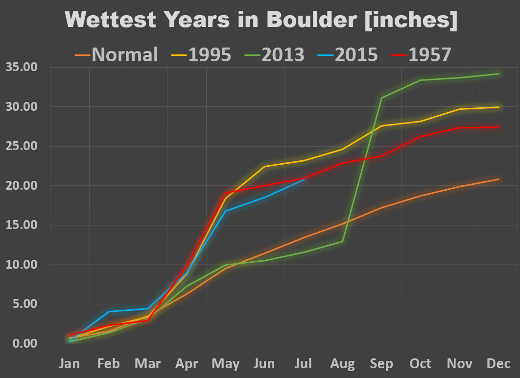
Though July 14, Boulder has recorded 20.77″ of precipitation, putting 2015 in 3rd place for most precip through July, behind only 1995 and 1957. Keep in mind, the annual average precipitation is just 20.23″, so we’ve already surpassed that. Shown below is time series for some of the wettest years in Boulder, depicting how the precipitation was distributed through each calendar year.
2015 and 1957 are nearly neck-and-neck at this point. Interestingly, 1957 was an El Niño year, the 4th strongest since 1950. The 2015 El Niño is forecast to be even stronger. While the monsoon can be enhanced by El Niño, beyond that, through the fall, there is little correlation with precipitation in Boulder. For example, despite a very wet start to the year, 1957 ended on a relatively dry note, receiving 2″ less than normal for the July-December period.
As of now, it is quite likely 2015 will end up the 3rd wettest year on record for Boulder. With a little moist misfortune, it could possibly take the number two spot. Surpassing 2013, the year of Boulder’s biblical September flood, is nothing more than a pie in the sky.
Stay up to date on this matter by following us on Twitter or Facebook and by subscribing to the site to get our latest posts automatically delivered to your email box (enter your email in the sidebar widget to right).





You must be logged in to post a comment.