A strong, spring-like snowstorm is taking shape for mid-week. In this week’s outlook, we discuss the weather before, during, and after the storm which will bring more than a foot of snow and blizzard conditions to portions of Colorado.
Before the storm
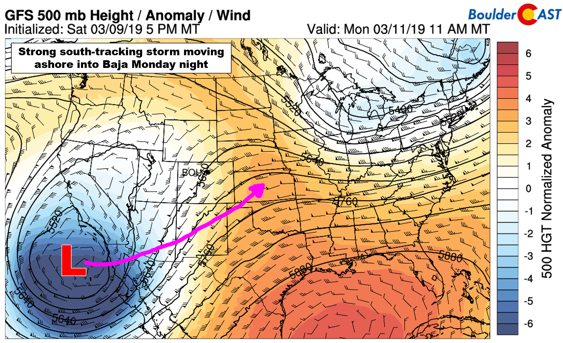
As of Monday morning, the storm we are tracking is located off the coast of Baja California. In general, the storm will be moving through southern Arizona, New Mexico and into western Kansas by Wednesday.
As the system approaches, warm and moist south and southwest flow will strengthen across Colorado. This will bring warmer temperatures statewide, along with added instability for the development of rain and snow showers, primarily across the higher elevations.
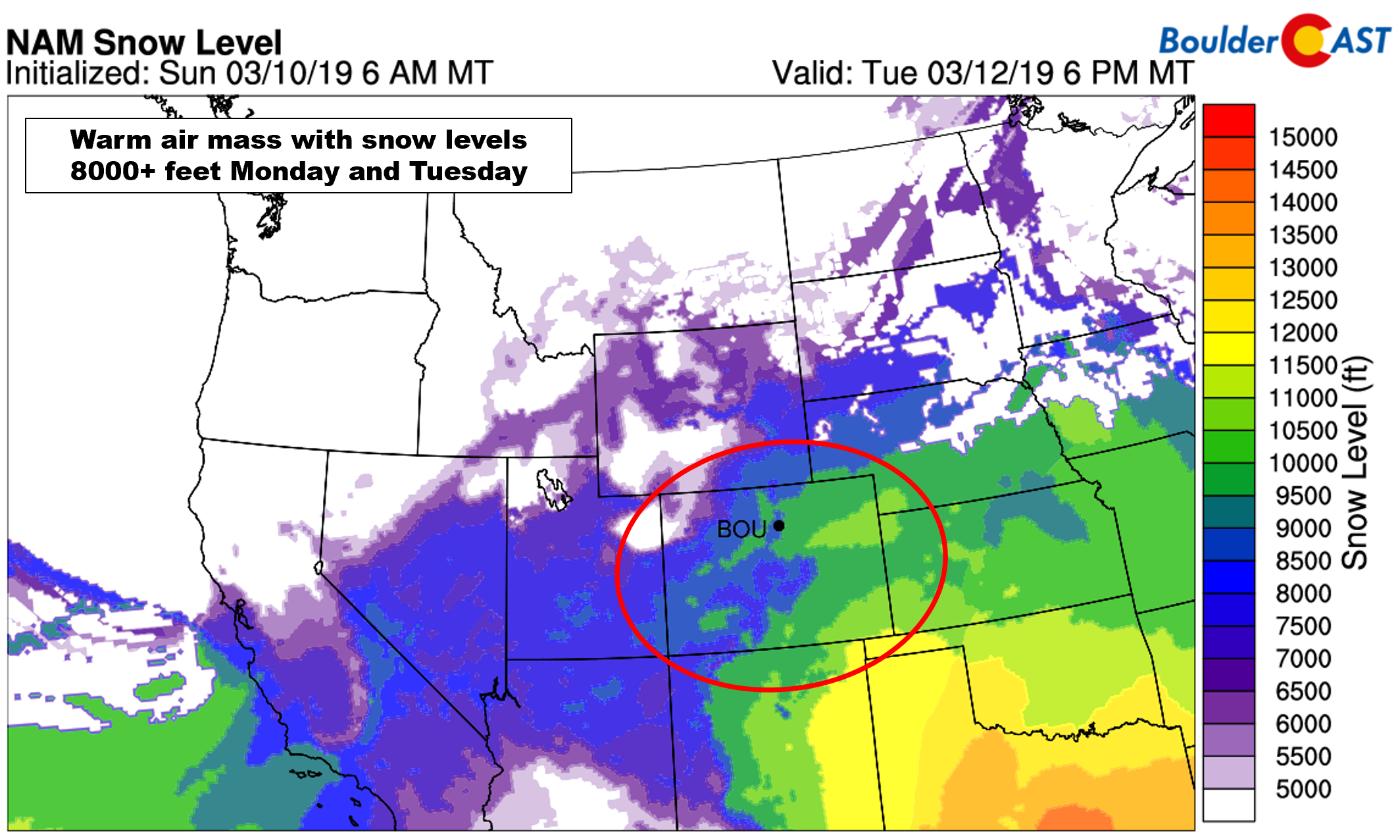
Late in the day on both Monday and Tuesday, some of these showers could spread eastward into the Metro area. The airmass is very warm with snow levels well above 8000 or even 9000 feet. Thus, if we see anything, it will be all rain, with a rain/snow mix in the higher Foothills.
Outside of this slight rain chance, the weather will be decent early in the week, with highs reaching near 50 on Monday and then into the lower 60’s on Tuesday.
During the storm
We preface by saying that what follows is only our preliminary discussion of the storm. We’re seeing enough model variations in the track of the system and the resulting wind fields across the Front Range to know this forecast is far from a simple one…
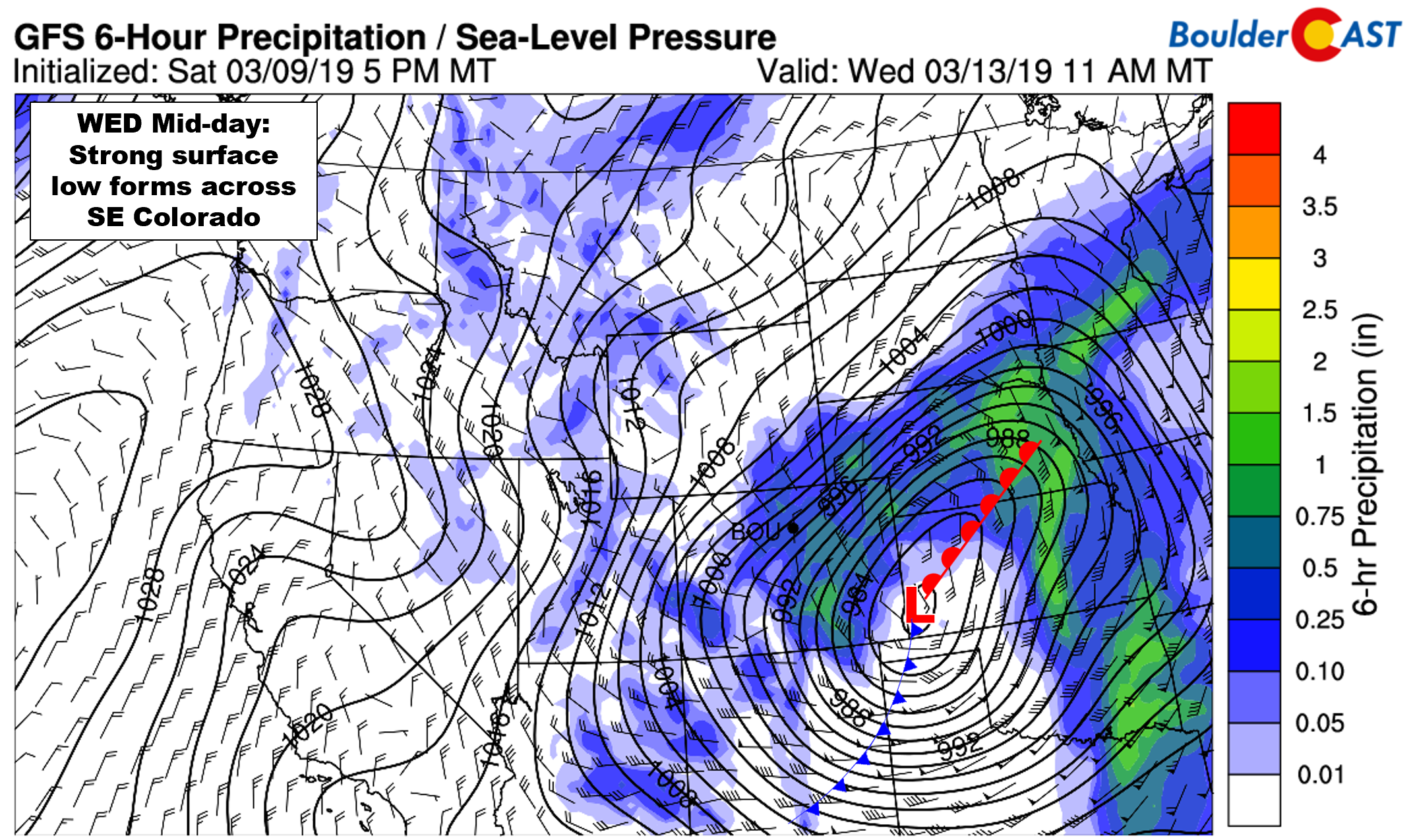
As the upper-low makes it across the Continental Divide in New Mexico, strong lee cyclogenesis is expected to form a deep and powerful surface low in southeast Colorado Wednesday morning. We don’t typically see storms explode this rapidly over our area, but there is good model consensus of this for now, so we’ll go with it.
Take a look below at the surface lows predicted by the GFS and Euro models for mid-day Wednesday. The positioning is a little varied, which is normal more than 48 hours out, but look at the intensity….a central pressure around 975 mb. This magnitude of cyclone is comparable in strength to a Category 2 hurricane. In addition to heavy wet snow, areas northwest of this low will see very strong winds exceeding hurricane strength on Wednesday. Guidance has gusts between 75 to 85 mph near this low! It truly is going to be a BLIZZARD!
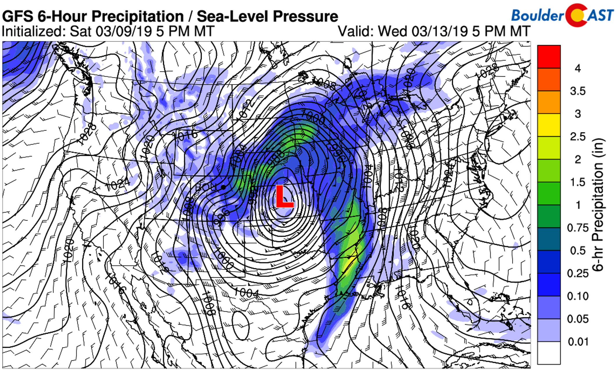
There’s no doubting the intensity of this storm. Its rapid intensification across southeast Colorado will bring it close to the threshold of being a bomb cyclone, the requirements for which are a 24 millibar pressure drop in less than 24 hours. The pressure field alone will stretch from the Canadian border all the way to the Mexican border. Quite the breadth!
If you’re hoping our forecast today includes reassurance that this monster storm will hit the Denver Metro area, you’ll unfortunately be slightly disappointed. We’re still seeing considerable variation between the major models on exactly how much snow falls in our area. The target for the heaviest snow and worst travel conditions will likely be east of Denver toward the Kansas and Nebraska borders. Most models trounce this area with more than a foot of snow and winds gusting in excess of 75 mph.
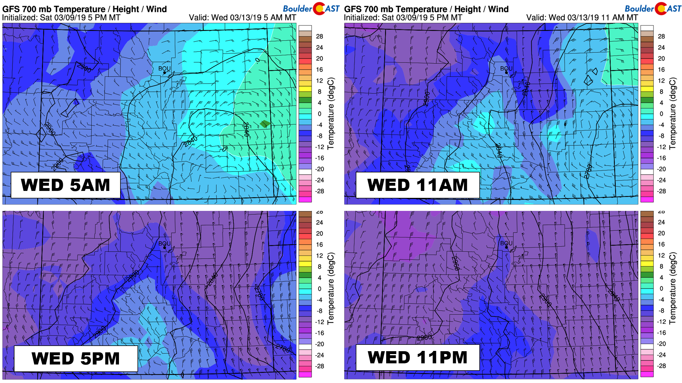
Across the Front Range, however, we need to be much more cautious with the forecast. Given the strength of the storm, we’re either looking at very strong upslope or very strong downslope, both of which offer vastly different outcomes. The breadth of the storm means that despite the surface low being so far SOUTH, the best upslope could end-up well NORTH of the Denver area in southern Wyoming. In rapid-intensification scenarios such as this, we often see winds turn extremely ageostrophic and flow almost directly into the center of the low pressure. If this happens, this would mean mainly downslope for the Boulder area. The graphic below shows that after a brief period of upslope at 700 mb Wednesday morning, strong northwesterly winds may develop through the rest of Wednesday.
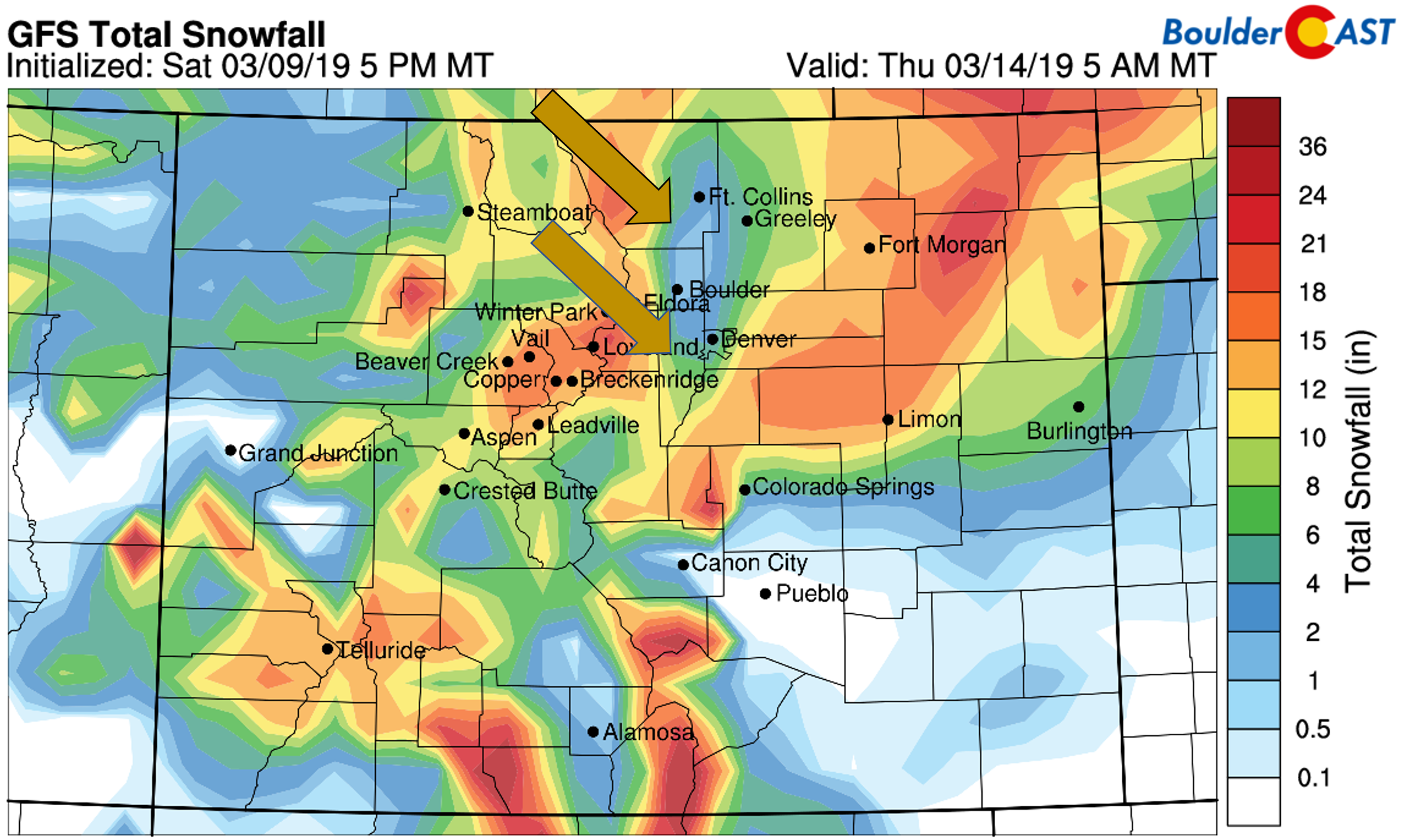
The result of this downslope would be a suppression of snow amounts in the western Metro area. The latest GFS snowfall forecast has a big “donut hole” with Boulder at the center.
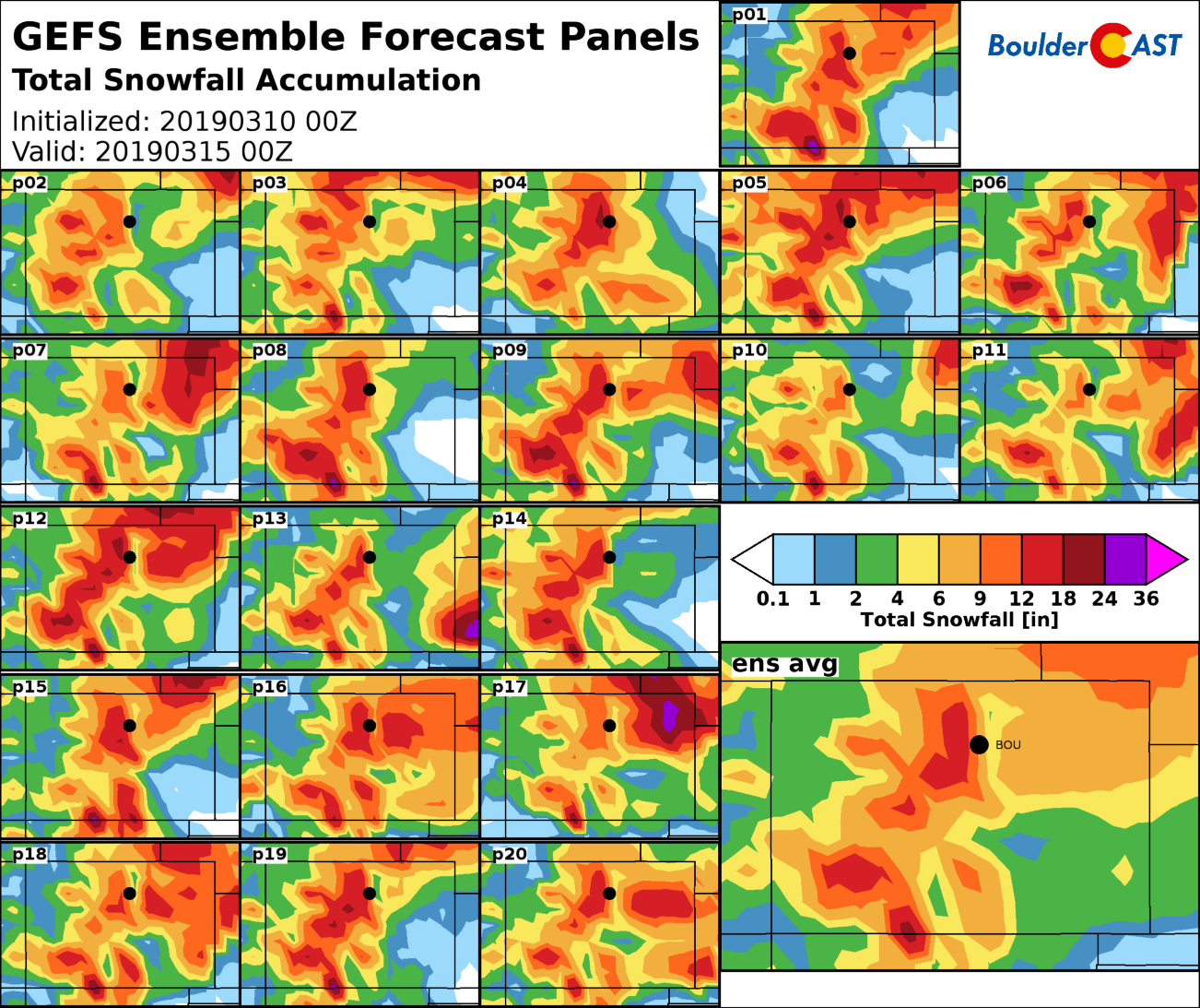
This is the just the prediction from one run of one model. The Euro is not showing quite as much suppression and has upslope going longer in Boulder. We do see the “donut hole” present in some form within at least half of the GFS ensemble runs, though.
As of Monday morning, our confidence in the “big one” is high across eastern Colorado in the wedged area outlined by Interstate 76 and 70. Travel in this area will be significantly impacted late Wednesday, possibly becoming impossible at some point. Power outages are also on the table given the intensity of the winds.
Closer to home, exactly what happens in the immediate Boulder and Denver area will need to be ironed out in the coming days. There are competing facets of the storm at work that at least has our confidence elevated that we’ll see at least a few inches of snow.
- If the storm tracks further north, we’ll be closer to the core of the low and catch some of the intense lift (and more wind)
- If it tracks further south, this will bring better upslope to our area.
Thus, on the lowest end of the spectrum, this should be at least a 2 to 5″ event for us. On the upper end, it has the potential for be a 6 to 12″ snowstorm, with possibly even higher totals in the eastern portions of Denver. The greatest limiting factor will be the speed of the storm, with the best setup for snow lasting only about 12 to 15 hours.
Our forecast for now on Wednesday: Expect a mild morning with rain showers turning to snow before mid-day, then snow widespread through the afternoon and evening. Snow could indeed by VERY heavy at times. North winds will be gusty especially in the evening and overnight with blowing snow likely.
We’ll post our final forecast and snowfall map sometime Tuesday. Subscribe to get instant email notifications for all of our storm updates, forecasts, and posts
We respect your privacy. You can unsubscribe at any time.
After the storm
As our big storm ejects into the Great Lakes late week, northerly winds will turn northwesterly across Colorado at 500 mb with a ridge building in as well. This will keep things cool but not too cold. Expect mostly cloudy skies on Thursday with highs in the mid to upper 30’s, then sunshine Friday with highs in the 40’s.
Forecast Specifics:
Monday: Partly to mostly cloudy with isolated afternoon and evening rain showers across the Plains and snow showers in the higher Foothills. Expect highs near 50 degrees on the Plains and in the upper 30’s in the Foothills.
Tuesday: Warm with increasing clouds through the day. Isolated rain showers are possible by evening into the overnight hours. Highs in the lower 60’s on the Plains and upper 40’s in the Foothills.
Wednesday: Overcast with a mild morning. Colder air will filter in, quickly changing rain to snow by mid to late morning with snow lingering through the afternoon and into evening. Snow could be heavy at times, especially east of Denver. Winds during the afternoon and evening could gust to 30 mph around Boulder, and above 50 mph east of Denver. Expect a morning high in the upper 30’s falling into the mid 20’s by evening.
Thursday: Mostly cloudy and cool with highs in the upper 30’s for the Plains and in the upper 20’s in the Foothills.
Friday: Mostly sunny with a few late day clouds. Highs in the low to middle 40’s across the Plains with lower 30’s in the Foothills.
High Country: Warm and moist southerly flow will bring widespread snow showers to southern Colorado Monday and Tuesday. The northern Mountains will see just isolated snow showers through Tuesday afternoon. As the main storm system arrives, widespread snow will overtake the state Tuesday night into Wednesday night with significant accumulations likely for most ranges. Lingering moist northwest flow will keep some snow going in the Mountains on Thursday. Friday will mainly be dry across the state. Check PowderCAST for updated forecasts for all the Colorado ski resorts.
DISCLAIMER: This weekly outlook forecast was created Monday morning and covers the entire upcoming week. Accuracy will decrease as the week progresses as this post is NOT updated. To receive daily updated forecasts from our team, subscribe to BoulderCAST Premium.
.
Share our forecast!






You must be logged in to post a comment.