More 90’s are in the forecast to begin the week, but the longest heat wave of 2018 comes to an end for the Front Range by mid-week.
Florence rainfall totals
Rain totals from slow-moving Florence surpassed 20″ in some parts of southern North Carolina. In fact, early data suggest Florence will break the all-time record for rainfall from a single tropical system in the state. As of Sunday night, the highest total reported was 33.89″ in Swansboro, NC. This is nearly 10″ above the previous record (Hurricane Floyd 1999). Multiple other cities also beat the old record. The map below on the left shows radar-estimated precipitation totals. Anywhere in white is more than 20″.

(LEFT) Radar estimated rain totals from Hurricane Florence. (RIGHT) Rainfall reports as of Saturday afternoon from North Carolina.
As of Monday morning, Tropical Depression Florence sits over eastern Kentucky with a broad shield of rainfall extending across Ohio, West Virginia, and Virginia. Heavy rainfall and some flooding are possible as the storm rapidly pushes northeastward in the next 48 hours. However, the worst is now behind us.
Hot weather continues
The temperature at BoulderCAST Station has reached 90 degrees on each of the last 7 days…our longest 90+ streak of 2018.
The pattern for Monday and Tuesday this week remains largely unchanged. While the East Coast deals with the remnants of Hurricane Florence, warm southwesterly flow and ridging continue to be the story for Colorado.
This will keep our temperatures near or just above 90 degrees for both Monday and Tuesday here in the Metro area. The record high each day is 93 degrees in Boulder. We’ll probably come up just a shade short…
Expect morning sunshine to give way to partly cloudy skies each afternoon. On Monday, models are showing the potential for a storm or two to form north of Denver towards Cheyenne. This is associated with a weak jet feature pushing across the region. Any storm activity would be high-based, with brief gusty winds but little if anything in the way of rainfall. Tuesday will be dry.

GFS precipitation forecast for Monday evening. Isolated showers are possible north of Denver towards Cheyenne.
Changes begin Wednesday
As we move into the middle part of the week, changes start to take shape for the entire West. The trough the has been hesitant to leave the Pacific Northwest finally moves eastward. We will begin to see influence from this trough here in Colorado on Wednesday in the form of increased cloud cover and cooler temperatures. Wednesday will probably be the first sub-90-degree day in Denver since September 9th.
It will still be fairly warm on Wednesday as the trough axis won’t fully pass until Wednesday night. There is considerable differences in the models in regards to Wednesday’s temperatures, however, ranging from highs in the middle 70’s (NAM) to the low 90’s (Euro). Intuition leads to our forecast highs being in the 80’s.

800 mb temperature forecast for Wednesday from the GFS (left) and NAM (right) models. There is large differences in the models right now resulting in a range of about 15 degrees for highs on Wednesday.
For precipitation, we’re not expecting much with this system. There may be a few isolated showers across the Mountains moving eastward on the Plains late Wednesday evening and night, but the night-time passage of the trough really isn’t ideal.
The moment the trough passes, drier and cooler air will filter into Colorado from the west. This will lead to a pleasant end to the week with sunshine and temperatures comfortable in the mid 70’s to lower 80’s.
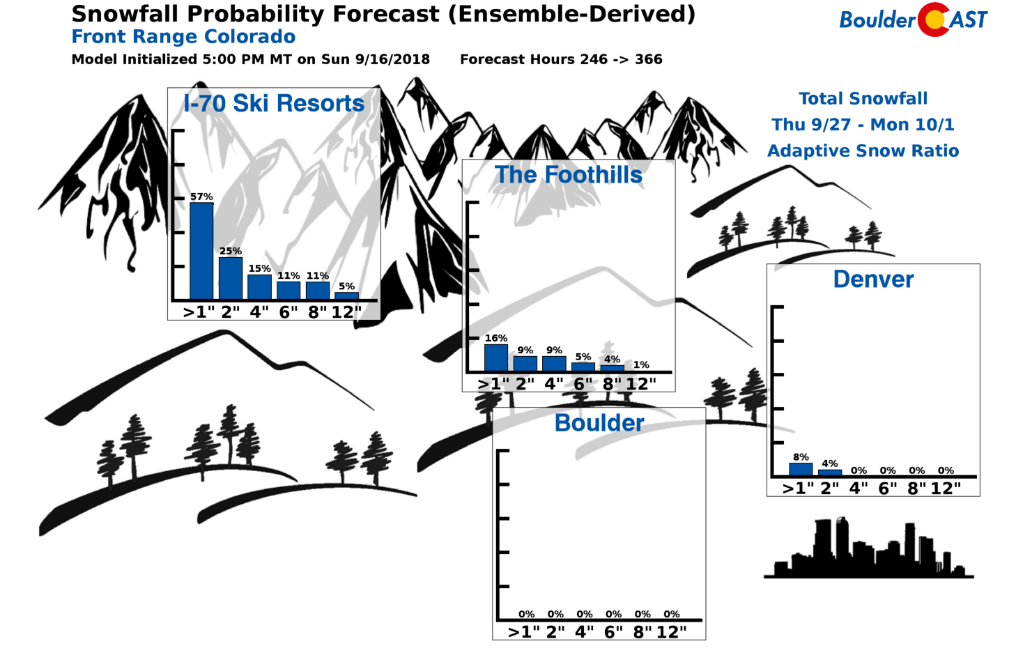
Finally, we’re starting to see some indication in the models of the changing seasons. Yes, there are non-zero chances for accumulating snow in Denver towards the end of next week. A small glimmer of hope for those of you tired of summer…
Forecast Specifics:
Monday: Morning sunshine with partly cloudy skies in the afternoon. An isolated storm or two are possible from Denver northward. Hot with temperatures reaching into the lower 90’s for the Plains and in the upper 70’s in the Foothills.
Tuesday: Hot with increasing clouds through the day. Highs near 90 degrees on the Plains and middle 70’s in the Foothills.
Wednesday: Some morning sun, then mostly cloudy and warm. High temperatures in the mid 80’s across the Plains and mid 70’s in the Foothills. A few isolated rain showers may develop after sunset into the early morning hours.
Thursday: Morning clouds, then partly sunny and cooler. Expect highs in the upper 70’s for the Plains and in the middle 60’s in the Foothills.
Friday: Mostly sunny and pleasant. Look for highs in the upper 70’s for the Plains with upper 60’s in the Foothills.
Weekend: The upcoming weekend will see temperatures remain near of slightly above normal with quiet weather statewide. Expect lots of sunshine and no chance of precipitation….great for enjoying the first weekend of autumn.
High Country: There will be a slight chance of showers in the Mountains Monday through Wednesday…and we do mean slight. Near-record warmth will encompass the higher elevations as well Monday and Tuesday, with cooler weather the rest of the week closer to normal. Check out our SummitCAST page for 6-day forecasts for more than 120 Colorado mountain destinations!
DISCLAIMER: This weekly outlook forecast was created Tuesday morning and covers the entire upcoming week. Accuracy will decrease as the week progresses as this post is NOT updated. To receive daily updated forecasts, subscribe to BoulderCAST Premium.
.
Share our forecast!


You must be logged in to post a comment.