The Denver area had a great weekend with temperatures above normal. The week ahead starts out warm, but takes a quick dip midweek to more seasonally appropriate weather. In the High Country, rain and snow will be possible at times, but over the Plains, mostly dry conditions will dominate. Read on for our full weekly forecast.
Much of the same for Columbus Day
The week will start out relatively tranquil and experience much of the same weather as Sunday. In fact, temperatures will be near 80 degrees today. Below shows the mid-level pattern for this afternoon, indicating a broad trough over western Canada, southwest flow for Colorado, and a weak shortwave trough over Kansas. The trough to the north in Canada will be our focus for tumbling temperatures by midweek. Though for now, expect lots of sunshine for your Monday.
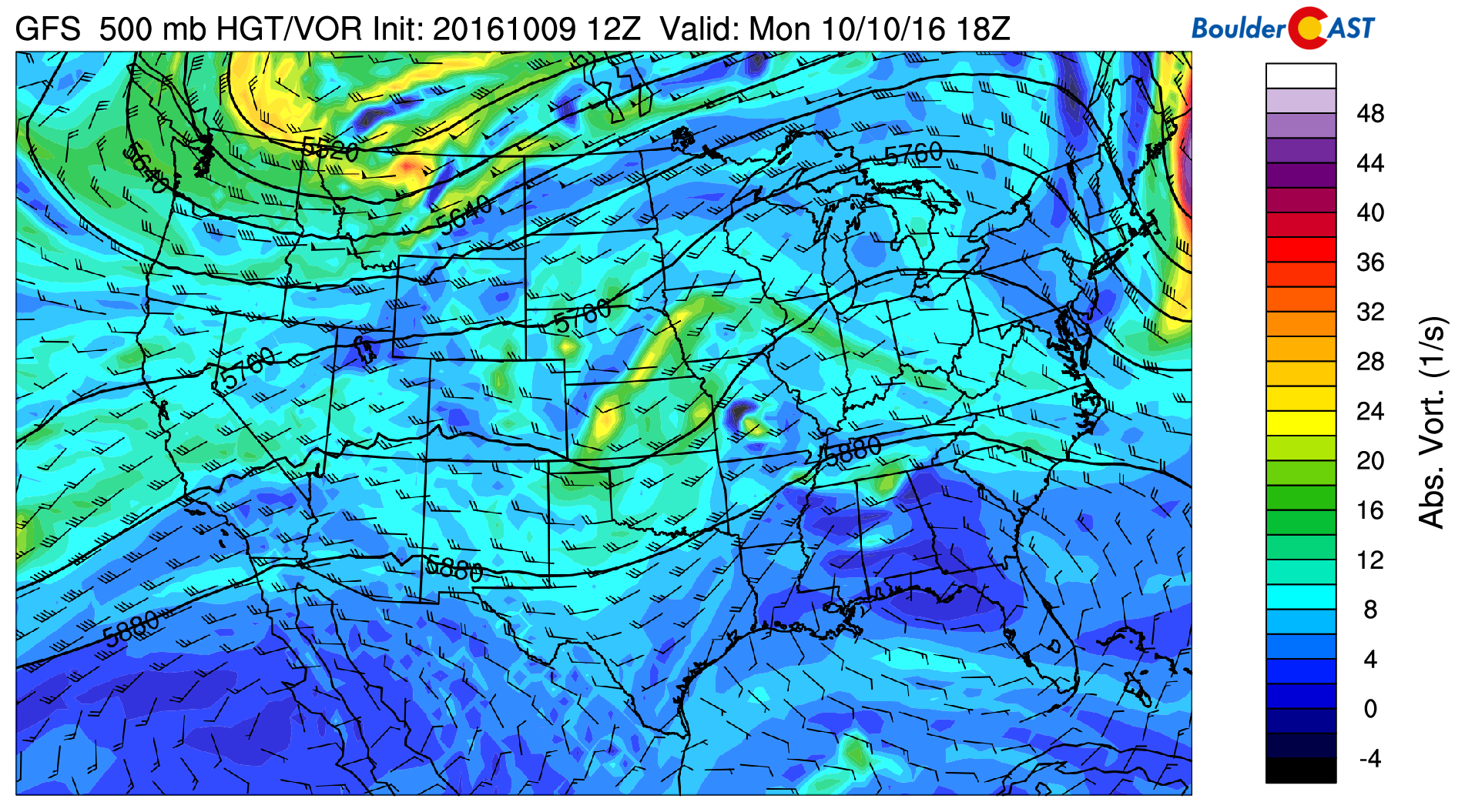
GFS 500 mb height and vorticity field for today
Not all will be quiet across Colorado today. The subtropical jet (shown below) will aid in upper-level divergence to provide lift for some scattered rain/snow showers over western Colorado. We don’t expect much in the way of widespread snow, but it is a reminder that powder season is here.
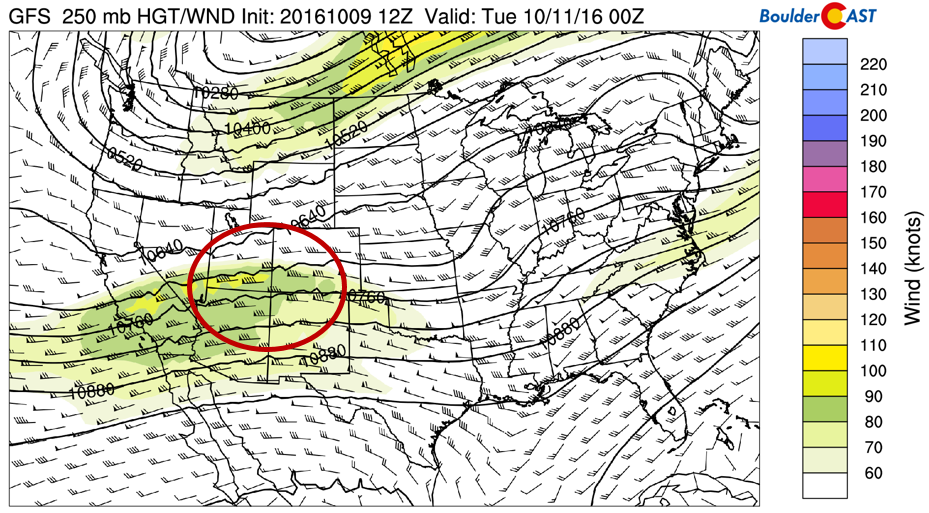
250 mb wind and heights for today. Area is red shows upper-level divergence for lift over the western mountains
Clouds roll in Tuesday ahead of cold front
Below shows the 500 mb mid-level flow on Tuesday. It has a trough moving southward out of Montana and Wyoming. To the south, weak shortwaves are moving through Colorado embedded in the southwesterly wind. This will filter in upper-level moisture from the Pacific Ocean and lead to high clouds through the day on Tuesday.
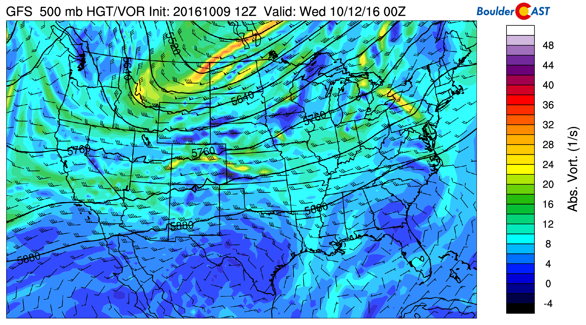
500 mb height and vorticity for Tuesday
Another perspective on these clouds can be gained by looking at a time-height plot of relative humidity (or RH for short), which is a measure of atmospheric saturation and a good metric to infer cloud cover (see below). The two regions circled in black show the relative humidity values for Tuesday and Thursday. Focusing on Tuesday, RH values will be above 80% in the mid and upper-levels of the atmosphere. This will keep our temperatures in the lower 70’s.
There will be a chance of isolated storms Tuesday in advance of the front connected to surface instability. Any storms will be rather spotty and most of us will stay dry.
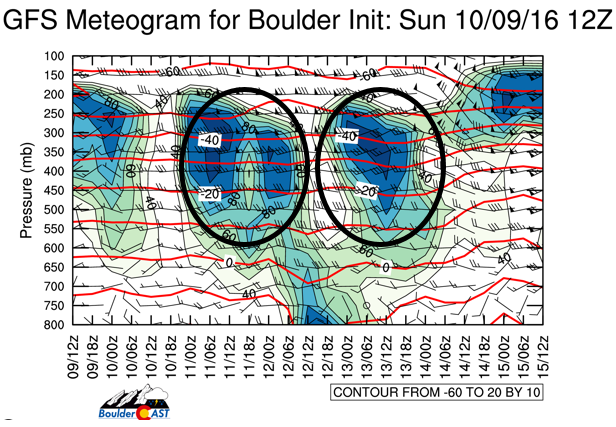
Time-height plot of temperature, relative humidity, and winds from the GFS for the week ahead
Now, focusing on Thursday, the GFS shows another area of high upper-level RH. This is in connection to a weak shortwave. The GFS is known to have a bias of high RH at longer lead-times. Nevertheless, Thursday has the chance to be yet another overcast day.
The southwesterly flow will aid in snowfall for portions of the mountains. This snow will continue off and on until Thursday afternoon. The GFS model is indicating that through Thursday, a few mountain areas could see 1-3″ of snow. Nothing major, but something to keep in mind if you are heading out or driving up there. Cold, nighttime temperatures will continue for the Mountains, which is good news for the ski resorts, since snow-making has already commenced!
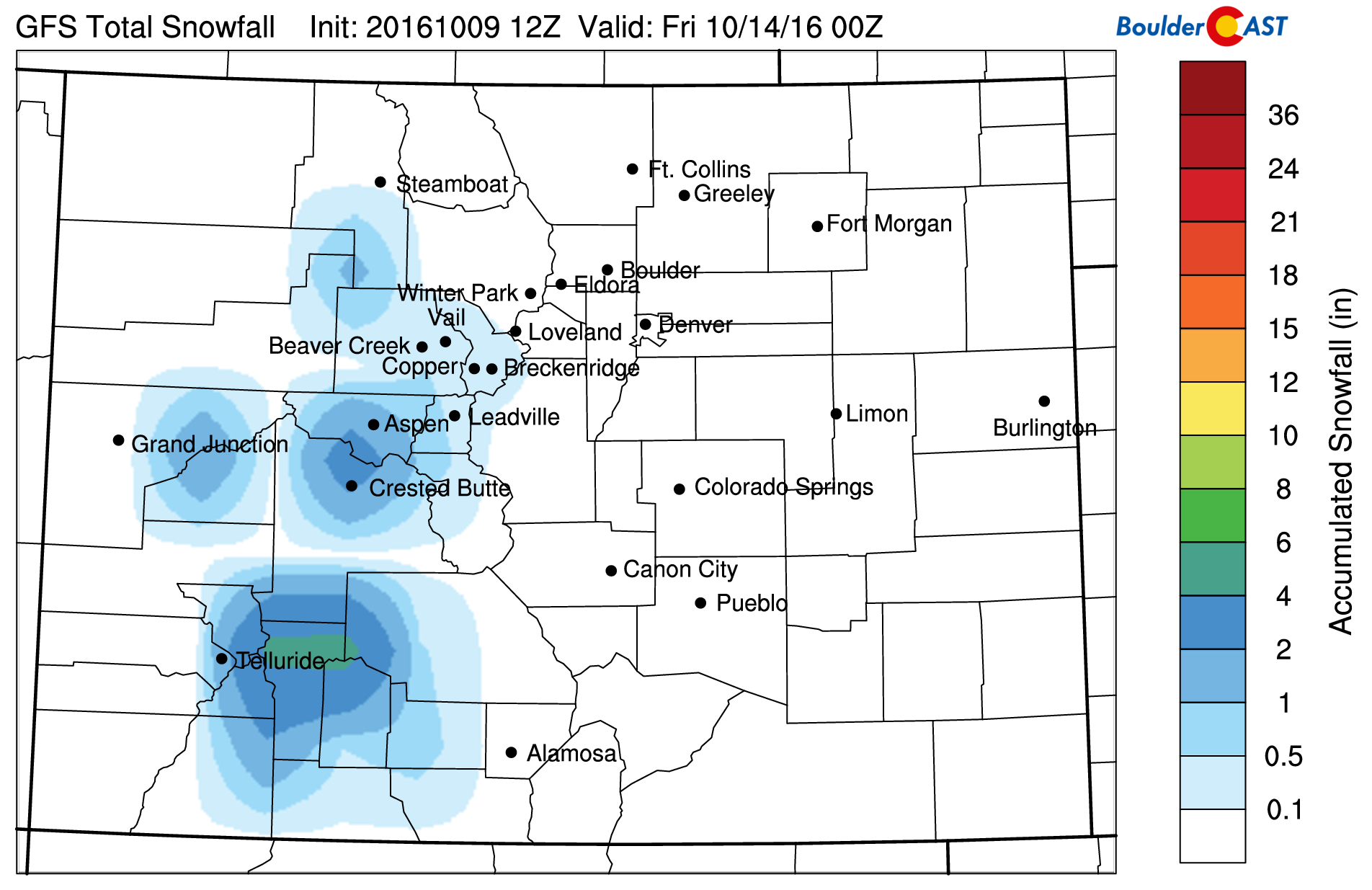
GFS predicted snow totals through Thursday
Cold front arrives Wednesday AM
A push of cold air reaches Boulder and the Plains late Tuesday night, around midnight. In response to that, low clouds and some spotty drizzle are probable in the morning Wednesday. However, the surface winds will quickly shift from a northeasterly direction to a southeasterly one, which should lead to eventual afternoon sunshine. Nonetheless, temperatures will still be much colder than they were to start the week.
Below shows the 20-member GFS ensemble of 700 mb temperatures, a proxy for the cold airmass moving in Wednesday. 700 mb temperatures will drop from ~ 8 degC on Monday to ~ 2 degC Wednesday. As a result, expect a big change in high temperatures, likely only in the upper 50’s on the Plains. The GFS ensemble has a large spread in forecasted temperatures, so uncertainty is elevated. Be sure to keep up with our DayCAST posts if you are a Premium subscriber!
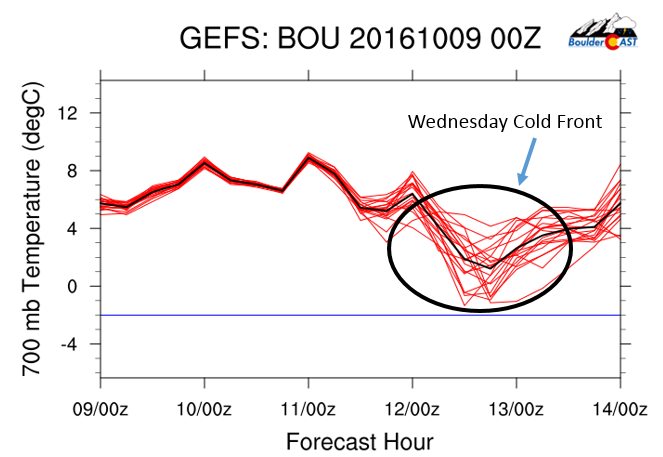
GEFS ensemble plume forecast of 700 mb temperatures, a proxy for the cold airmass Wednesday
Week closes calm
Below shows the main features important on Thursday. It is hard to pick out, but there is a weak shortwave trough over central Colorado. This was mentioned as a feature in the time-height plot earlier. It will mostly introduce high clouds over the state of Colorado, with no chance of precipitation. Keep in mind, we are in a drought and could really use some rain, or better yet, snow! Temperatures will warm compared to Wednesday, but with cloud cover around, we’ll stay near normal (60’s).
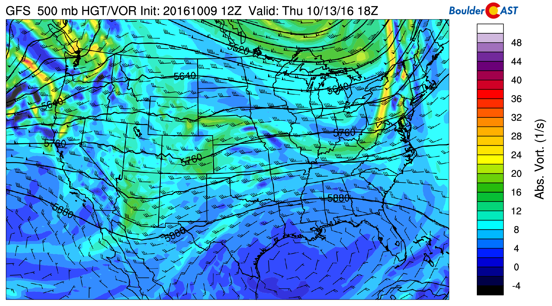
GFS 500 mb height and vorticity field for Thursday
On Friday, both the GFS and European forecast models indicate a large ridge of high pressure taking shape over California. Colorado will be to the east of this ridge, with warm southwesterly flow. Highs could return back to the low 80’s, depending on the exact location and strength of the ridge. By and large, a great end to the week!
Hopefully next week brings a little more precipitation, or at least some marginally more exciting weather to discuss with you!
Forecast Specifics:
Monday: A few high clouds but overall lots of sunshine with highs in the upper 70’s in most areas, with low 80’s in some portions of the Plains. Over the Foothills, temperatures to be in the upper 60’s.
Tuesday: Mid and high-level clouds off and on through the morning and afternoon. Expect partly sunny skies as a result. Temperatures will be in the lower 70’s on the Plains to the lower 60’s in the Foothills. A spotty shower/storm is possible in the evening, but most areas to remain dry.
Wednesday: Morning low-level clouds and spotty drizzle (especially in and near the Foothills), followed by sunshine in the afternoon. Highs much cooler in the upper 50’s across the Plains and upper 40’s in the Foothills.
Thursday: Partly sunny skies and quiet. Highs in the upper 60’s over the Plains and upper 50’s across the Foothills.
Friday: Mostly sunny and warm. Temperatures climbing into the lower 80’s on the Plains and upper 60’s in the Foothills.
High Country: Some light rain/snow showers will be possible Monday evening and Tuesday morning. Gusty winds are likely Tuesday and Wednesday, along with the chance of snow. Expect 1-3″ for some of the ski resorts and higher peaks. Dry weather will return Friday to end the week, but gusty southwest winds will remain.
Extended: Longer-range model forecasts are showing a more active northern Pacific jet stream late weekend and next week. However, these forecasts also keep the cold air well to our north. What this means for us is uncertainty since it is so far out. But, if the jet stream shifts ever so slightly southward, it could lead to snow chances for the Mountains.
Mon
Tue
Wed
Thu
Fri


Temperature
80
74
58
67
81


Precip Chc (Plains)
0%
10%
0%
0%
0%


.



You must be logged in to post a comment.