Following a weekend of pleasant weather across the lower elevations and heavy snow in the Mountains, northwest flow will linger this week leading to temperatures remaining on the cool side.
Snow winding down in Mountains
Compliments of moist northwest flow and a strong jet streak across the state, heavy snow piled up in the Mountains this weekend. Some areas reported more than 18 inches since Friday, including Steamboat, A-Basin, and Loveland Ski Resorts.
As of Monday morning, the snow showers are winding down across the higher elevations as the deeper moisture moves eastward. A few additional inches of accumulation are expected on west facing slopes during the day Monday.
Northwest flow week
A broad trough will remain in-place across the northern Great Plains and Great Lakes regions through the entire week. This will keep west-northwest flow going over Colorado from now into the upcoming weekend. You can see the rather persistent set-up at 500 mb in the height animation below. Pay particularly close attention to the west and northwest flow in Colorado.
As mentioned, drier air is now moving into the state and this will be the case through the week. Lacking the always-important ingredient of moisture, the northwest flow will be more of a nuisance than anything for the Front Range. Expect just isolated snow showers in the Mountains on Monday and Tuesday, with dry conditions the rest of the week.

GFS pecipitable water anomaly forecast for Tuesday showing drier air moving into Colorado in the northwest flow.
Across the lower elevations in Boulder and Denver, we will feel the effects of the northwest flow mainly in the form of fluctuating temperatures as weak disturbances traverse across the northern Rockies. Forecasting how far south and west the associated cold fronts make it will be a challenge, especially heading into the latter part of the week. Thus, temperatures become slightly uncertain for northeast Colorado on Thursday and Friday.
We’ll also be dealing with gusty conditions at times on Monday and Tuesday as winds from a strong jet overhead mix down to the surface a tad.
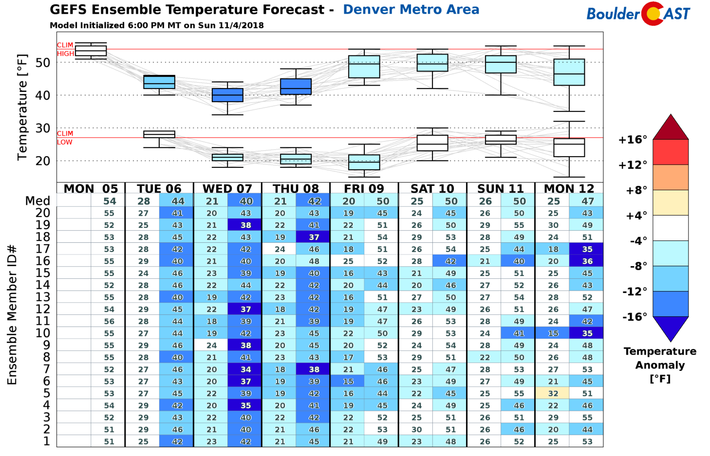
Expect Monday and Tuesday to be the warmest days of the week with highs in the upper 40’s to middle 50’s. Winds could gust in the 20 to 30 mph range each day with generally sunny skies. A disturbance that is moving across the Great Plains will bring a cold front into northeast Colorado Tuesday night, followed by another frontal push possibly on Thursday. This will knock our temperatures back into the 30’s and 40’s the rest of the week (see below). The coldest days will most likely be Wednesday and Thursday with highs in the upper 30’s to lower 40’s.
Though it looks like we’ll see temperatures moderate slightly late in the week, we do caution that models have been going back-and-forth as to whether the really cold air across the center part of the country is able to back into northeast Colorado. The latest runs of the GFS and Euro keep the cold front just east of the Denver Metro area. This will need to be watched as the week progresses as it could mean the difference between temperatures in the 50’s or the 20’s for Friday.
The only real, albeit slight chance of precipitation this week for the Metro area comes Wednesday night as a weak system moves through. The GFS produces a few flurries in the Metro area, while the Euro brings in…shall we say….light snow showers. The downslope pattern should keep things very isolated and light in the immediate Denver area, with maybe a slightly better chance of snow showers further east in Colorado. It doesn’t look like a major concern at all right now, just a chance of a few flakes with little to no accumulation. We’ll keep you updated if things change.
Finally, look out for an extended period of cold overnight low temperatures this week. We’ve been relatively lucky so far this autumn with very few nights actually dropping into the 20’s (in Boulder at least). That changes this week with 20’s and even some teens expected daily.

Previous 30 days temperature record from BoulderCAST Station. Highs (red), lows (blue), and mean (green) temperatures are shown.
Forecast Specifics:
Monday: A few morning clouds, then mostly sunny and breezy with highs in the middle 50’s on the Plains and in the lower 40’s in the Foothills. Winds could gust up to 20 mph during the afternoon.
Tuesday: Mostly sunny early, then partly cloudy and breezy with winds at times gusting to 30 mph. Highs in the upper 40’s on the Plains and in the middle 30’s in the Foothills.
Wednesday: Partly to mostly sunny and cooler with highs in the low to middle 40’s across the Plains and in the lower 30’s in the Foothills. Isolated snow showers are possible overnight into early Thursday, mainly east of Denver, with no accumulation expected.
Thursday: A few morning clouds, then mostly sunny and cool with highs near 40 degrees in the Plains and middle 30’s in the Foothills.
Friday: Sunny and dry with highs in the 40’s for the Plains and 30’s in the Foothills.
High Country: After heavy snow in the Mountains over the weekend, drier air filtering in will lead to just isolated snow showers on Monday and Tuesday, mainly north of Interstate 70. A strong jet is overhead, so it will be very blustery as well on these days. Mostly sunny, dry, and cool weather will be in place Wednesday through Friday.
DISCLAIMER: This weekly outlook forecast was created Monday morning and covers the entire upcoming week. Accuracy will decrease as the week progresses as this post is NOT updated. To receive daily updated forecasts, subscribe to BoulderCAST Premium.
.
Share our forecast!


You must be logged in to post a comment.