
We have one more day of hail to deal with on Monday before a major pattern change curbs the threat of severe storms for the Front Range. Later in the week, a developing ridge across southern Colorado will usher in conditions very typical for July with temperatures definitely returning to the 90’s.
Hail-filled weekend, more possible Monday
The “four-day” holiday weekend was very active weather-wise for us, with hail reported every day except Saturday across the Denver Metro area. The extended period of severe storms was spurred on by a favorable and persistent weather pattern that took shape around the middle of last week:
- A stagnant trough over the northern Rockies provided cold air aloft and also moderately strong southwest flow in the mid levels across Colorado
- A surface boundary pushed southward across eastern Colorado. This brought slightly cooler temperatures, but more importantly significantly boosted low-level moisture
- These two factors led to a diurnally unstable airmass with lots of available bulk shear
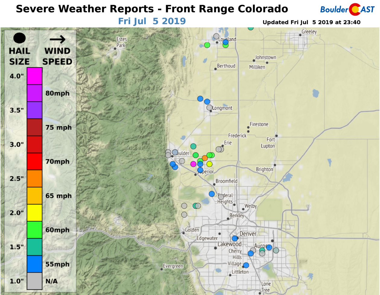
By far the worst day for hail was Friday, July 5th. Early day cloud cover cleared, but we still needed to see temperatures rise into the low to middle 80’s to realize the explosive 2000-3000 J/kg of available CAPE due to a low-level capping inversion in the atmosphere. It took until nearly sunset, but we did it! After 6:00 PM, completely sunny skies rapidly filled with massive, elongated supercells up and down the Front Range. The most devastating one formed just west of Boulder and moved across the city around 7:00 PM. Watch the supercell develop in the radar animation below from this past Friday evening. This single storm remained well-defined for more than eight hours, tracking from the Foothills of Boulder County into southeast Wyoming where it merged with another complex of severe storms and eventually pushed off into Kansas.

Observed radar animation from the evening of Friday July 5th. Numerous supercells developed across the Front Range.
This single storm produced a swath of hail more than 75 miles long with hailstones up to 2.5″ in diameter, causing significant damage especially in the Louisville to Lafayette areas. We saw numerous reports of broken car windows and home skylights, and of course many commercial crops and gardens met their demise as well. Check our Severe Weather Reports page for all the reports over the weekend.
For Monday, we’ll see a nearly identical set-up to that of the weekend – southwest flow aloft and low-level moist upslope. This combination will again lead to the development of afternoon thunderstorms capable of producing hail. Aiding the lift will be a short-wave feature currently located across western Colorado (see below). The timing of this wave will coincide nicely with peak solar heating this afternoon.

GOES-East mid-level water vapor animation as of Monday morning. A disturbance is trekking across western Colorado and will aid in lift Monday afternoon for storms
The juiciest air has backed out of the Front Range, with dew points only in the low to middle 50’s around Denver. We’re seeing values in the low to middle 60’s further east.

As a result, the atmosphere will be less explosive around Denver and Boulder today compared to areas further east. Models are showing 600-1200 J/kg of CAPE for the Metro area, still plenty to produce strong to severe storms capable of near 1″ hail given the large-scale setup.
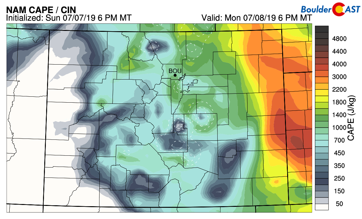
NAM CAPE forecast for Monday afternoon
The Storm Prediction Center includes both Boulder and Denver in the “Marginal Risk” for severe thunderstorms in their outlook. As expected, further northeast across the Plains has a higher risk of large hail and even damaging winds by early evening.

Look for highs in the low to middle 80’s with scattered strong to severe thunderstorms developing this afternoon. The best chances will be from 2:00 PM to 7:00 PM. Storms could produce hail up to 1″ in diameter anywhere in the Metro area.
Change is coming!
We are finally seeing the light at the end of the tunnel to oust the trough across the Pacific Northwest. We’ll see this transition happen on Tuesday when the trough exits northeastward into Canada and a ridge of high pressure develops across Colorado. This BIG change is shown in the 500 mb height anomaly forecast maps below.

GFS 500mb height anomaly forecast maps for Monday (left) and Wednesday (right). A big pattern shift is expected in the coming days!
As the trough exits, a cold front will move through late Tuesday evening. The position of the front at midnight Tuesday night is shown in the 800 mb temperature forecast map below. It doesn’t appear at this time any precipitation will accompany this front for us. There’s just not enough moisture and the night-time arrival will keep lift minimal. Highs Tuesday will be in the upper 80’s ahead of the frontal passage with mostly sunny skies.
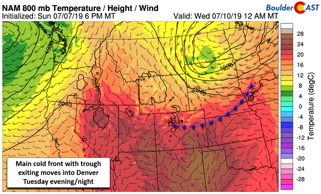
NAM 800mb temperature and wind forecast map for Tuesday night
By Wednesday, eastern Colorado will be cut-off from the flow of low-level moisture even further while large-scale subsidence from the ridge takes hold. This will lead to generally dry conditions for us. Post-front, Wednesday will likely be a few degrees cooler than Tuesday. Highs in the middle 80’s with mostly sunny skies and just isolated storms.
A typical early July pattern Thursday into the weekend
The aforementioned mid-level ridge will remain parked across southern Colorado and northern New Mexico right into the upcoming weekend. This will push the strongest mid-latitude flow and general storm track northward near the Canadian border. At the same time, persistent deep clockwise flow around the ridge will begin to advect sub-tropical moisture into Arizona and southern California.
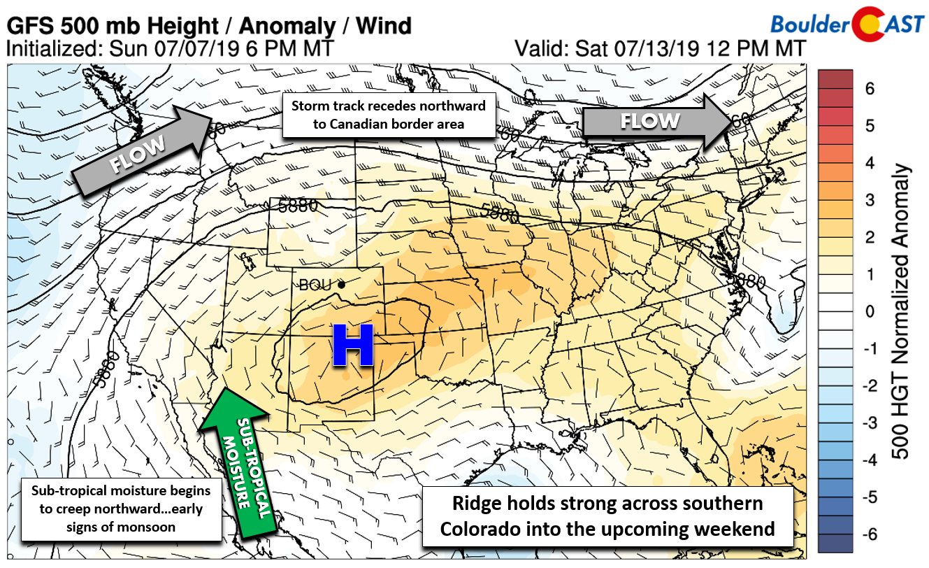
GFS 500mb height anomaly forecast for the upcoming weekend
This flow of moisture may be the early signs of the monsoon taking shape. A check on the latest dew points from Tucson, AZ shows that monsoon moisture has yet to arrive:
![]()
The net result of this pattern shift will be a return to typical July weather across the Front Range. Temperatures will push into the low to middle 90’s with very small chances for storms developing each afternoon and evening. This will be the case Thursday, Friday, and likely both days of the upcoming weekend…
Forecast Specifics:
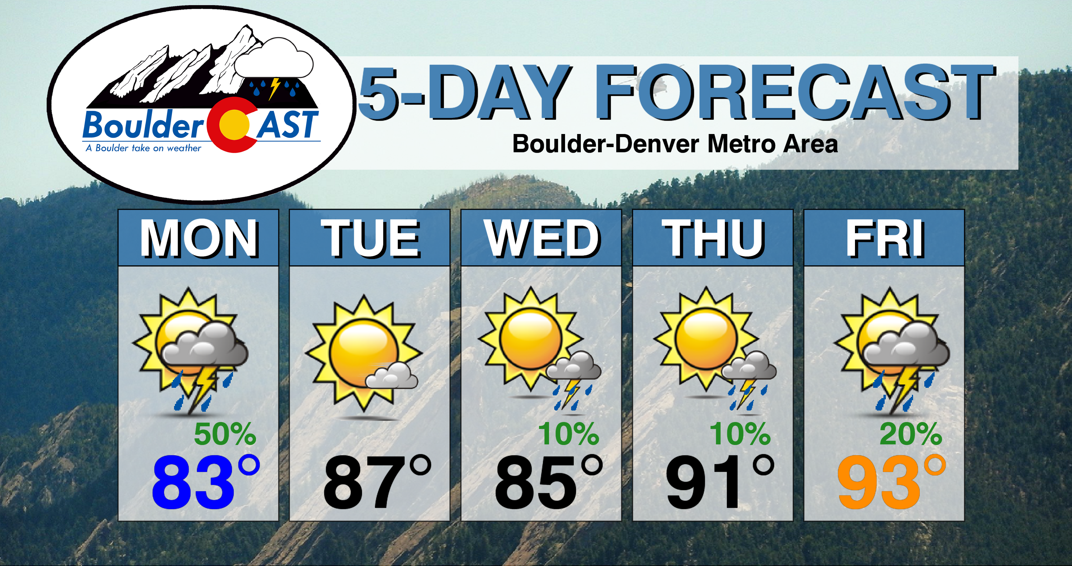
Monday: Morning sunshine with clouds increasing quickly by mid-day. Scattered to widespread thunderstorms develop through the afternoon and continue into mid-evening. Some storms could be severe with 1″ hail and heavy downpours. Expect highs in the low 80’s across the Plains and in the upper 60’s in the Foothills.
Tuesday: Mostly sunny, warm, and dry with highs in the upper 80’s across the Plains and in the middle 70’s in the Foothills.
Wednesday: Mostly sunny with isolated late-day showers, mainly across the Foothills. Highs in the lower to middle 80’s across the Plains and in the upper 60’s in the Foothills.
Thursday: Mostly sunny early, then partly cloudy with isolated afternoon and evening thunderstorms. Warmer with temperatures peaking in the low 90’s for the Plains and in the upper 70’s for the Foothills.
Friday: Hot, increasing clouds, and a slight chance of afternoon/evening storms. High temperatures in the low to middle 90’s for the Plains, with near 80 degrees in the Foothills.
High Country: Monday will offer the best chance of storms across the Mountains as a weak shortwave moves overhead. Expect scattered thunderstorms developing by mid-day and continuing into the evening. Tuesday will be dry, with just isolated late-day storms returning to the forecast Wednesday through Friday as a strong ridge develops across southern Colorado.
DISCLAIMER: This weekly outlook forecast was created Monday morning and covers the entire upcoming week. Accuracy will decrease as the week progresses as this post is NOT updated. To receive daily updated forecasts from our team, subscribe to BoulderCAST Premium.

.
Spread the word, share our forecast!


You must be logged in to post a comment.