As we enter Thanksgiving week, Colorado is bracing for a significant weather event fueled by a strong atmospheric river flowing in from the west. A potent storm system is set to sweep through the region Tuesday into Wednesday, delivering widespread heavy snowfall to the Mountains with significant disruption to travel expected. Meanwhile, the Boulder-Denver Metro area faces a more uncertain forecast with varying snowfall predictions due to warm initial temperatures and questionable upslope. Despite the midweek forecast challenges, we can all at least look forward to a definitively quiet but chilly Thanksgiving Day. Read on for a complete outlook of the weather week ahead.
This week’s highlights include:
- Atmospheric River to Flood the Mountains with Snow: A potent storm system sweeping in from the northwest will usher in deep moisture and heavy orographic snowfall to the High Country Tuesday through Wednesday leading to difficult travel in the Mountains but excellent ski conditions.
- Less Snow and Less Certainty for the Lower Elevations: This same system will bring snow to the Denver Metro area as well, but timing and amounts still vary amongst the guidance — the recent trends are towards lighter snow and minor travel impacts mainly on Wednesday.
- Chilly Temperatures: Temperatures will remain below normal through the week with the coldest readings expected midweek onwards.
- A Quiet but Chilly Thanksgiving: Weather is expected to be quiet and sunny for Turkey Day, albeit chilly with highs only in the 30s.
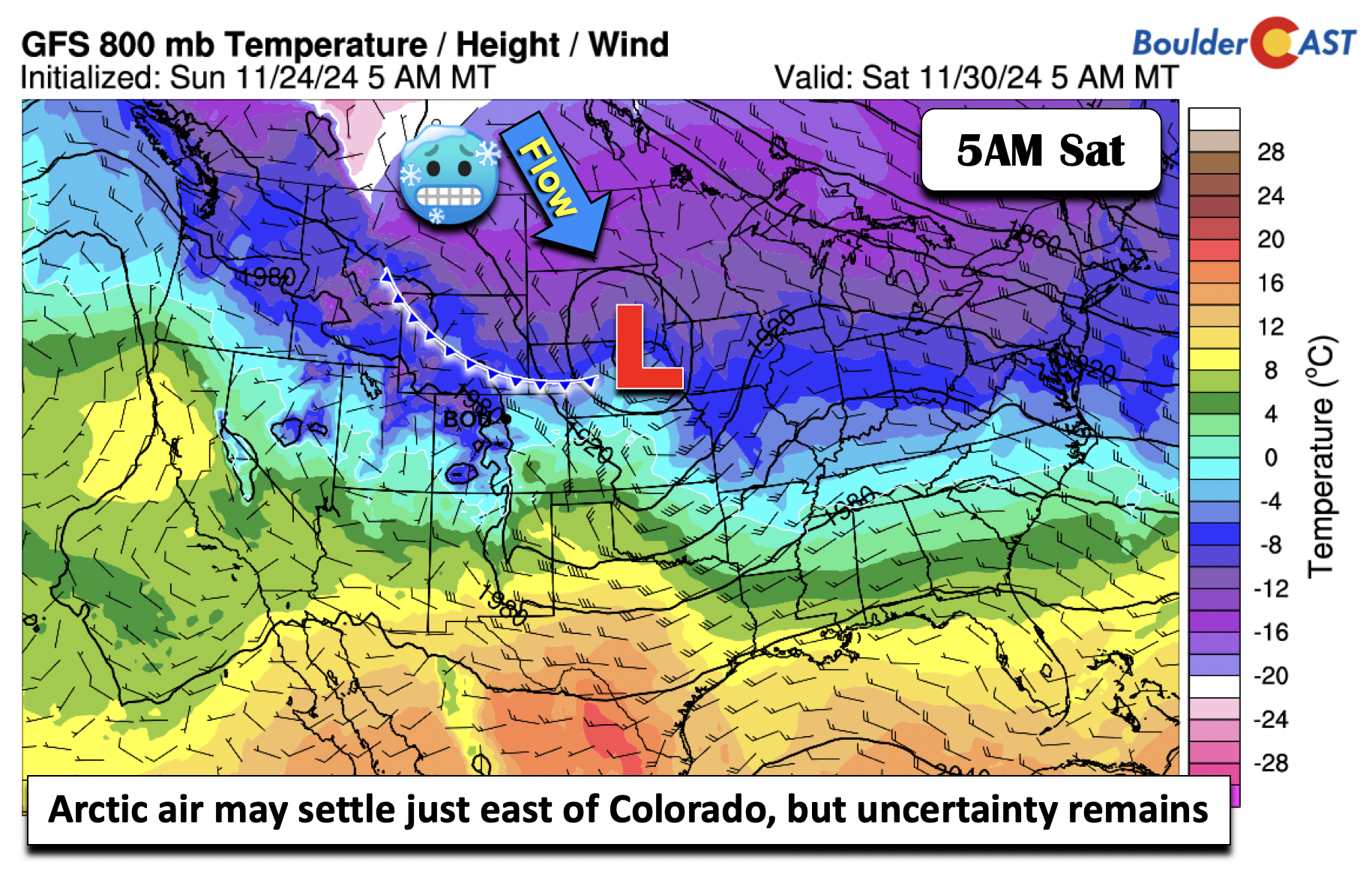
- Weekend Arctic Air? A surge of Arctic Air is set to move into portions of the northern Great Plains early in the upcoming weekend. Colorado could end up on the fringe of this cold air, but most likely we will be spared.
DISCLAIMER: This weekly outlook forecast is created Monday morning and covers the entire upcoming week. Accuracy will decrease as the week progresses as this post is NOT updated. To receive daily updated forecasts from our team, among many other perks, subscribe to BoulderCAST Premium.
Daily Forecast Updates
Get our daily forecast discussion every morning delivered to your inbox.
All Our Model Data
Access to all our Colorado-centric high-resolution weather model graphics. Seriously — every one!
Ski & Hiking Forecasts
6-day forecasts for all the Colorado ski resorts, plus more than 120 hiking trails, including every 14er.
Smoke Forecasts
Wildfire smoke concentration predictions up to 72 hours into the future.
Exclusive Content
Weekend outlooks every Thursday, bonus storm updates, historical data and much more!
No Advertisements
Enjoy ad-free viewing on the entire site.
Watching a potent midweek system
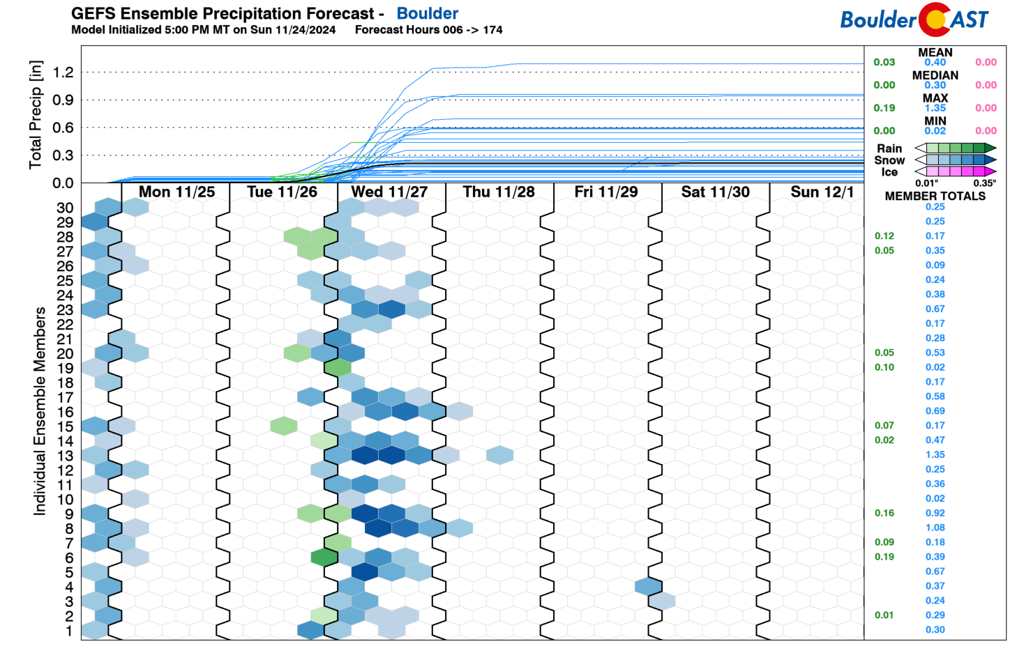
Our weekly outlook this time focuses on a potent midweek storm system, as seen in the GEFS forecast plumes below. We had a few light snow showers Sunday night across the area, but those are long gone and we are now focusing our attention towards the snow threat for Wednesday, the day before Thanksgiving. Nearly every GEFS ensemble member has rain/snow for the Front Range, but as we will see in a moment, the forecast is far from certain at this point.
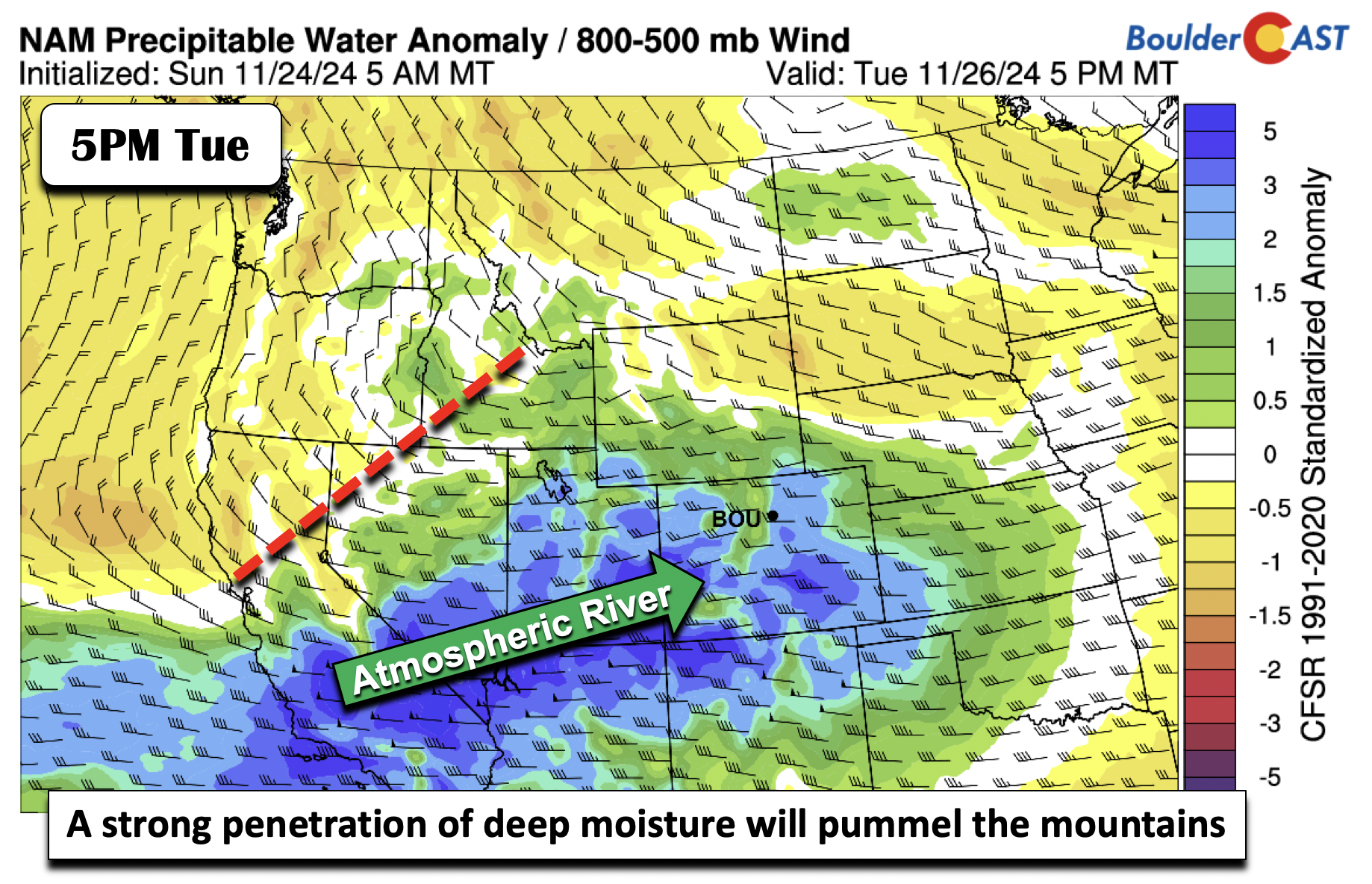
Our forecast confidence this week is much greater for the High Country, especially the mountains along and west of the Continental Divide which will get blasted with moderate to heavy snowfall over a roughly 42-hour period. A trough moving onshore Tuesday will direct a potent atmospheric river directly into the western portions of Colorado. Incredibly, moisture anomalies by Tuesday evening are forecast to exceed 3 standard deviations in many spots along this atmospheric river — this indicates that the moisture flowing into the state will be above the 99th percentile for this time of year.
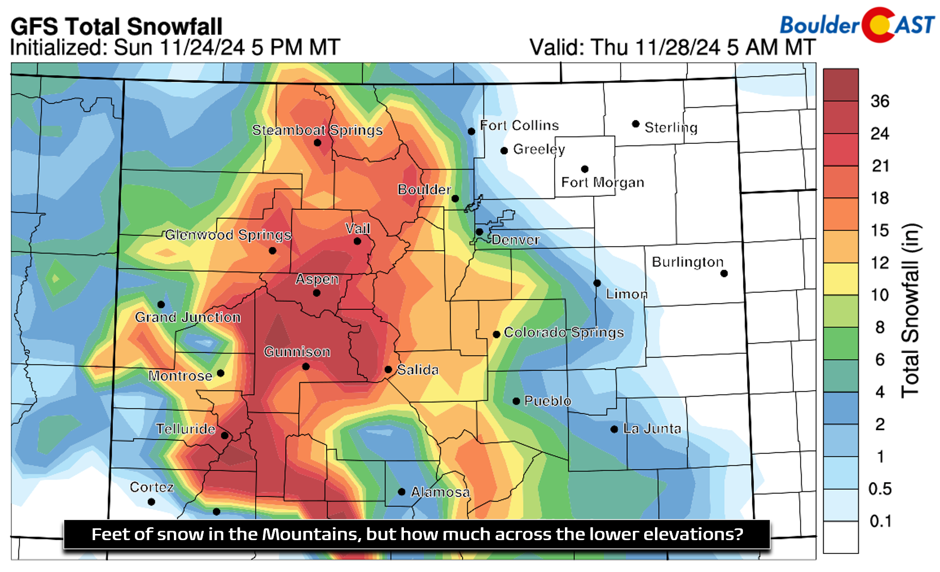
Snow will develop over the higher terrain early Tuesday morning and continue through much of Wednesday as moisture-infused west-southwesterly flow slams in to the terrain. The GFS shows impressive snowfall totals, similar to other models as well, with 1.5 to 2.5 feet of snow expected from Telluride to Aspen to Steamboat. The GFS also shows quite a bit of snow for Boulder and Denver, but we’ll discuss that in more detail soon…
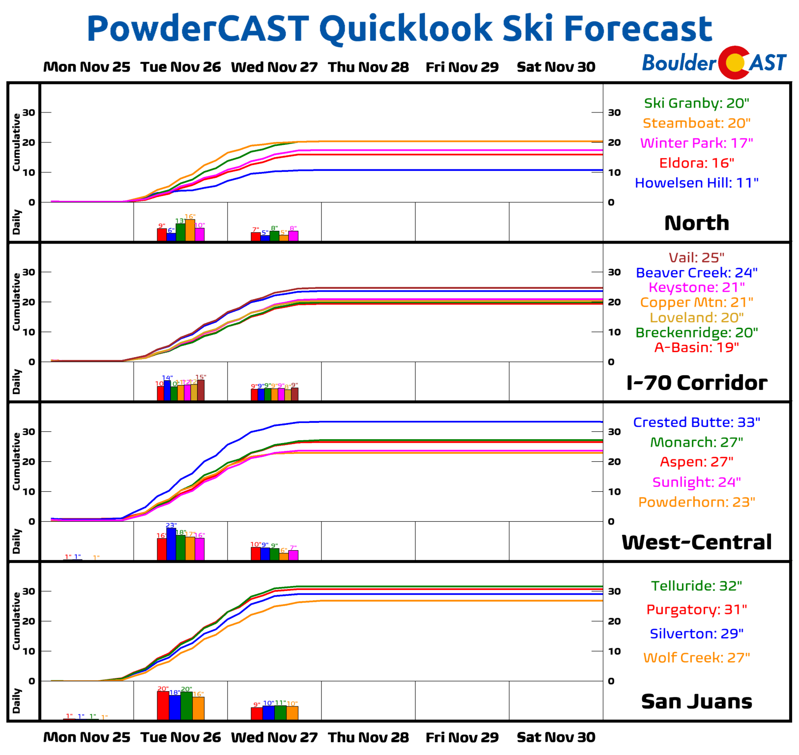
PowerCAST is currently advertising 1 to 2 feet of snow for most northern and central Colorado ski resorts, with nearly 3 feet possible in southwest Colorado! Regardless of the finer details of the midweek forecast, every outcome absolutely pummels the mountains with heavy snow. Skiers can celebrate with excellent downhill conditions for the Thanksgiving holiday and days prior! However, Mountain travel will be treacherous Tuesday and Wednesday especially, with road closures highly likely along the I-70 Mountain Corridor and elsewhere in the state. If you have holiday travel plans that involve lots of mountain passes, you may want to reconsider or get moving Monday if possible.
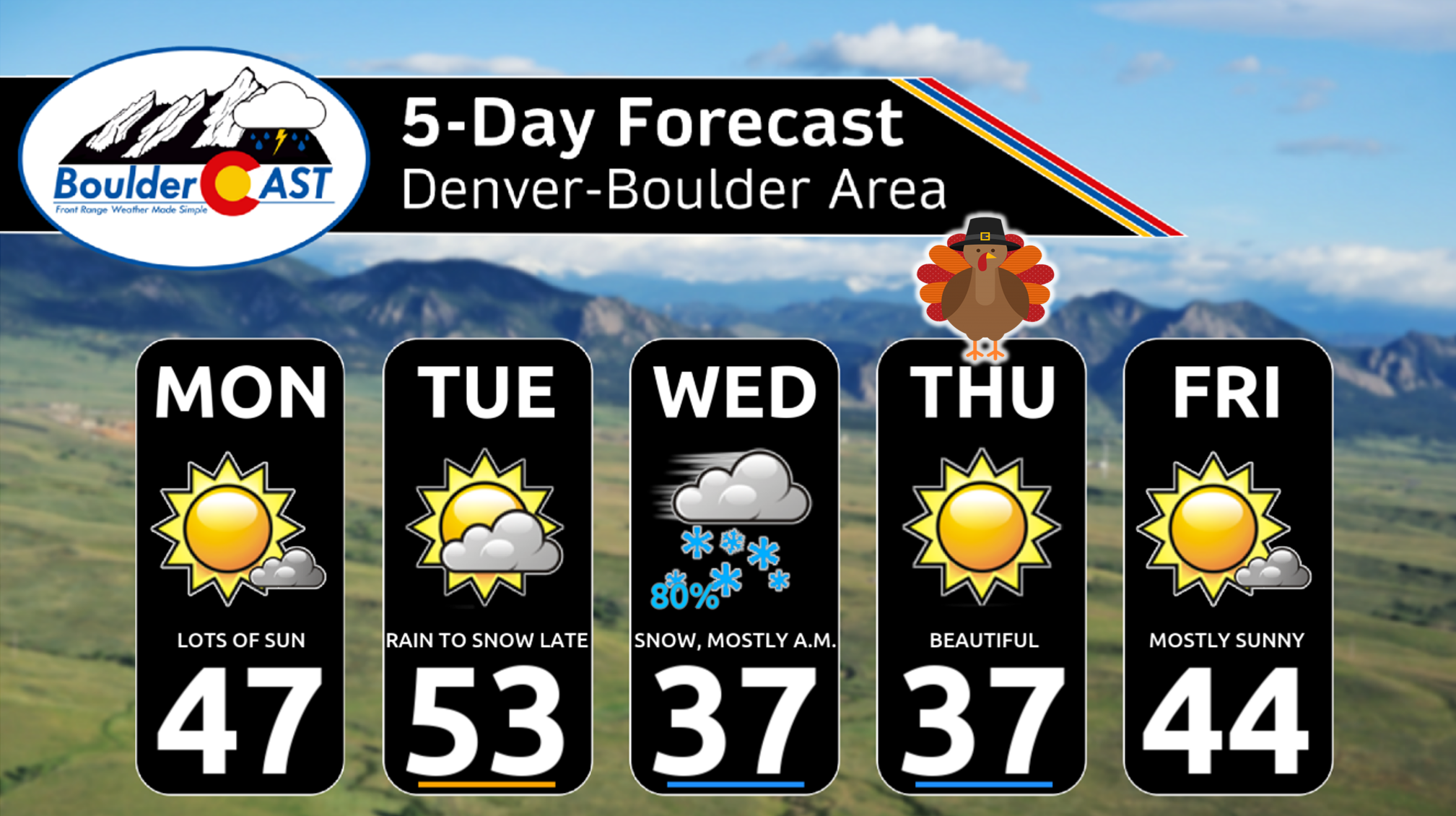
For areas east of the Continental Divide, the midweek forecast is far less certain, but overall impacts are expected to be much less. To begin this holiday week, Monday will be rather quiet with highs in the middle 40s. By Tuesday, we will be in between systems and some weak warming will take hold ahead of our mid-week trough. The Boulder-Denver area should reach the lower 50s Tuesday afternoon.
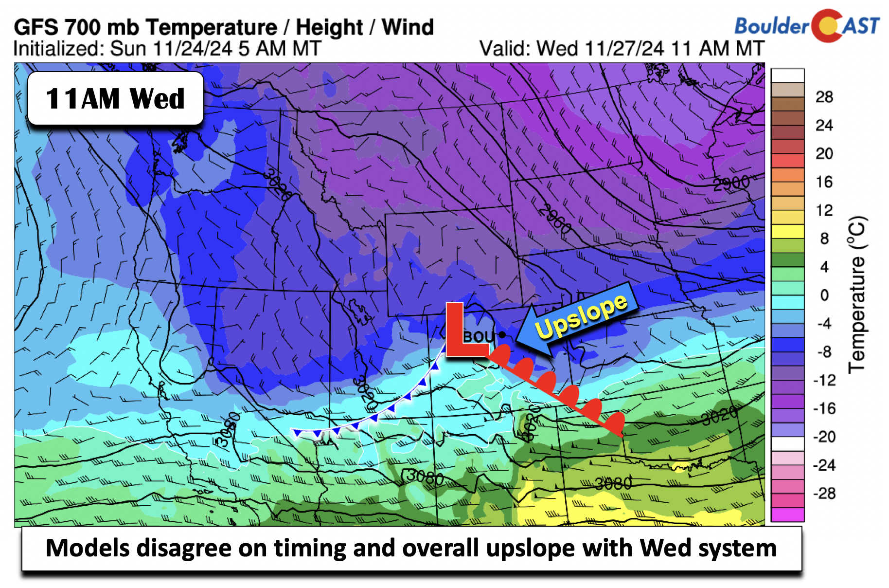
The main event of the week comes Tuesday night into Wednesday, when the guidance shows a disturbance tracking alongside a mid-level shortwave trough Wednesday. The models, however, disagree on the degree of upslope and timing — this obviously impacts our expected snowfall amounts across the lower elevations.
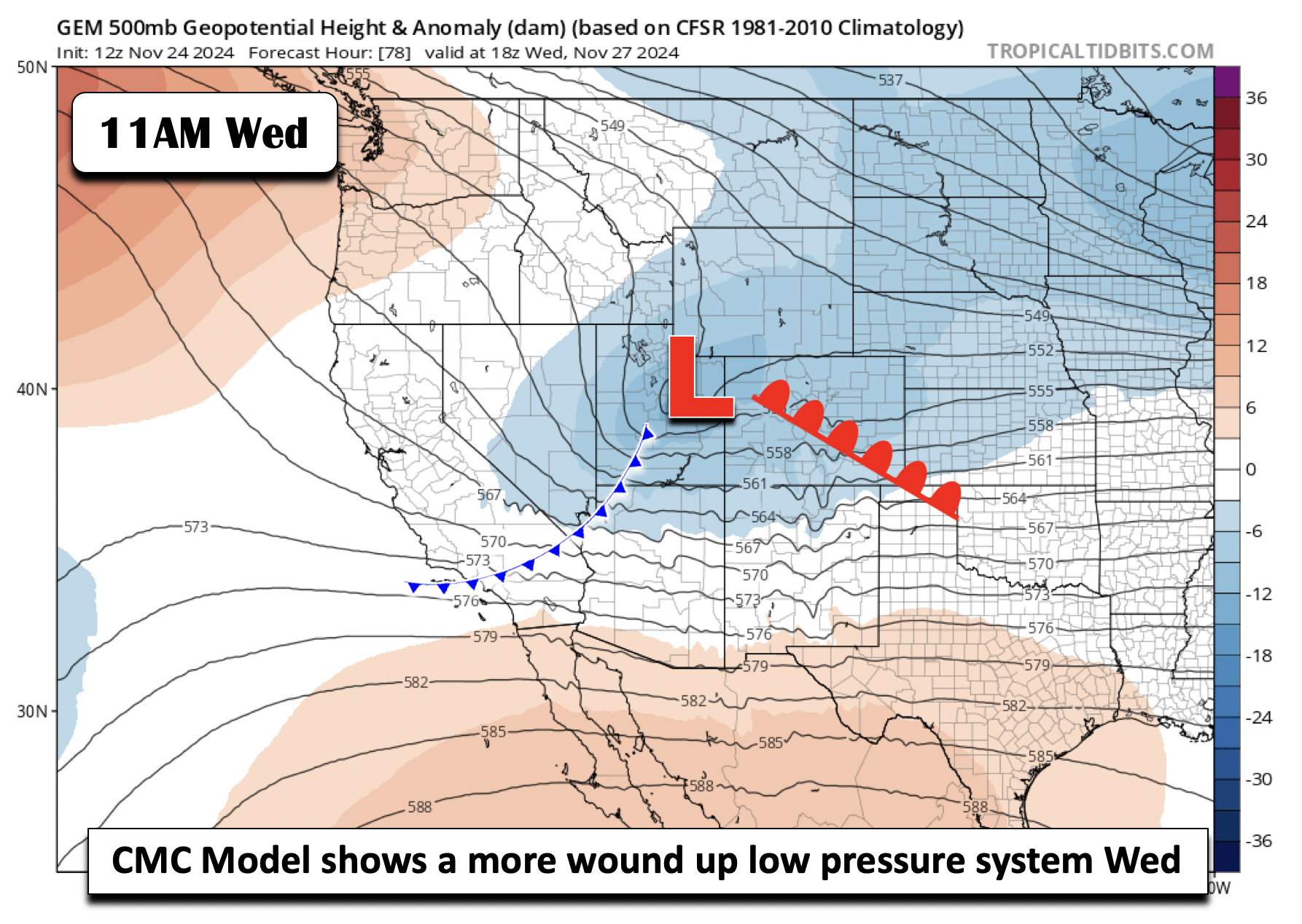
We will show three potential solutions from the CMC, GFS, and ECMWF for the midweek trough. First, the CMC model below (a.k.a the Canadian). The CMC shows a more wound up area of low pressure moving through, timing the movement Wednesday morning into Wednesday evening. This solution is the one with the greatest snowfall totals on the Front Range.
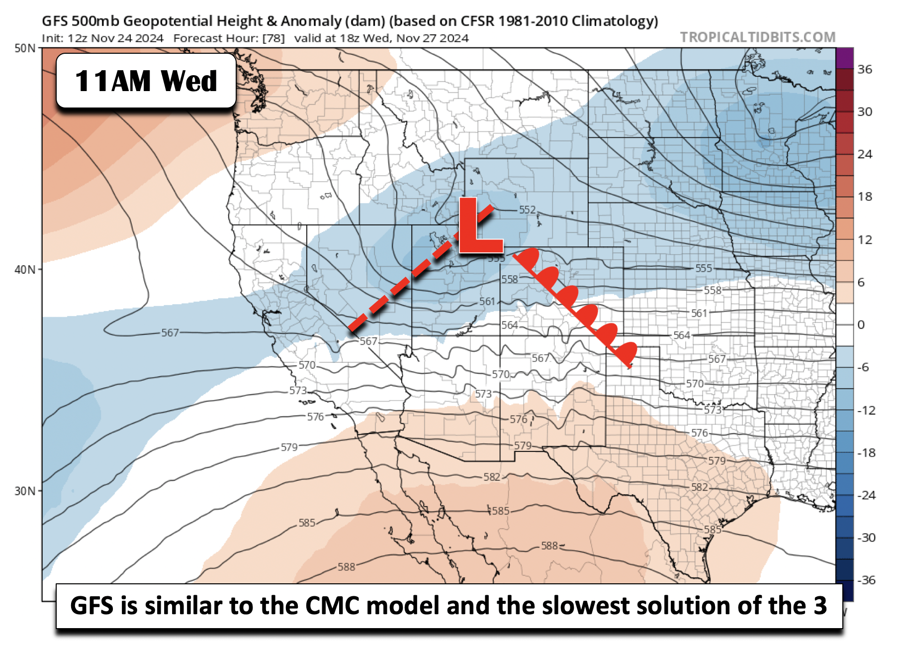
The GFS is similar to the CMC model, with a more potent low pressure system tracking through in the west-northwest oriented flow. It’s timing is delayed and it is the slowest of the three solutions, favoring Wednesday afternoon into late Wednesday night. The GFS has lower snowfall totals than the CMC, but still with many areas at above 4 inches of snow.
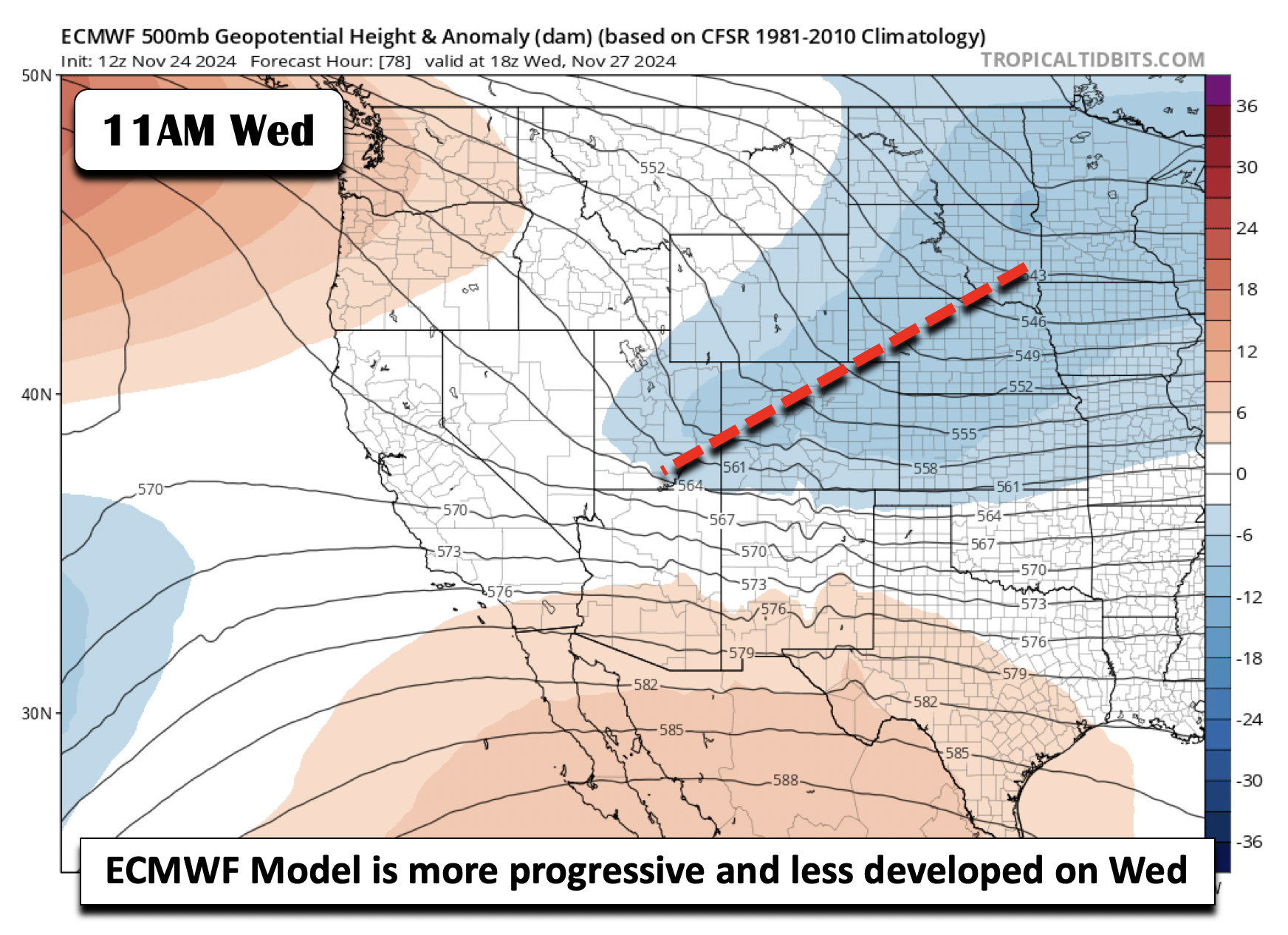
The Euro is probably the least snowiest and also the fastest of the global models. It shows a rather progressive shortwave trough. There is limited reflection of a low pressure system along the trough, favoring weaker or non-existent upslope. The Euro leads to the lowest snowfall totals, in the range of 1 to 5 inches.
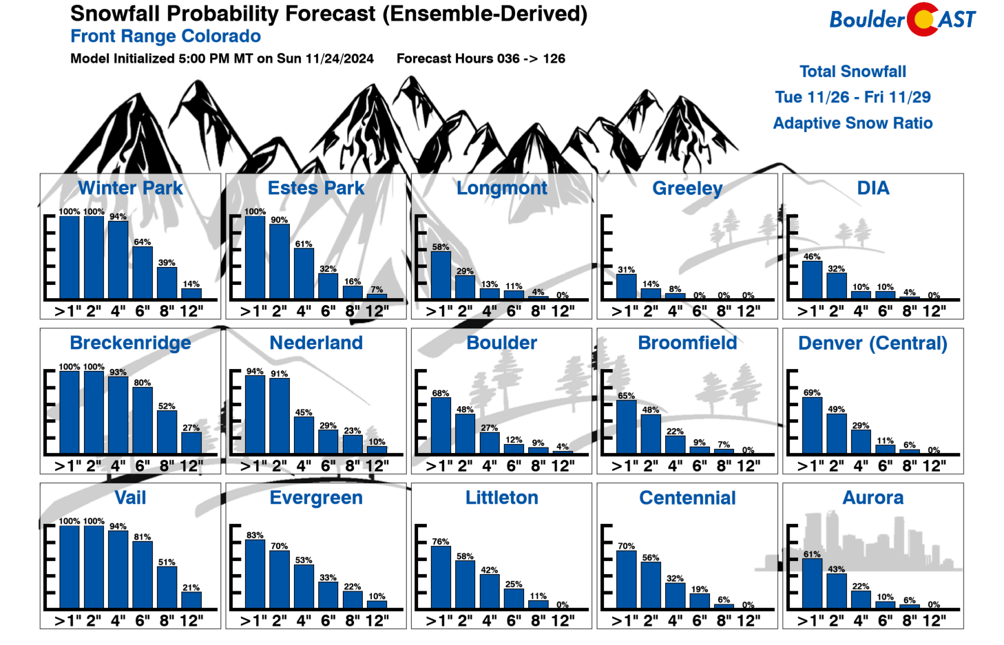
Given the large uncertainty still in the broader synoptic pattern, it is no surprise that we are not quite ready to forecast exact snowfall amounts just yet. We will say that there has been a downward trend in potential snowfall amounts over the last day or two of model runs for areas east of the Mountains. A look at our latest Snowfall Probabilities suggests that Boulder and Denver have decent chances to pick up an inch or two of snow (50 to 80%), while significant snow greater than 6″ is fairly unlikely (just 10-15%). Temperatures will also be an issue across the flatlands with initially things being too warm for snow Tuesday evening, but with an eventual change-over from rain to snow happening sometime Tuesday night. Wednesday is going to be a colder day, likely in the mid to upper 30s as a cold front moves south with the trough axis. Snow will be around in the morning hours, but will be tapering off through the day.
We will continue to mull over the forecast for the days leading up to Thanksgiving. Check back for our final snowfall forecast (and snow map) Tuesday morning!
Late-week or weekend Arctic Air?
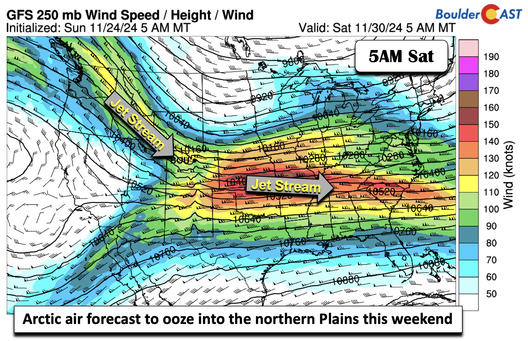
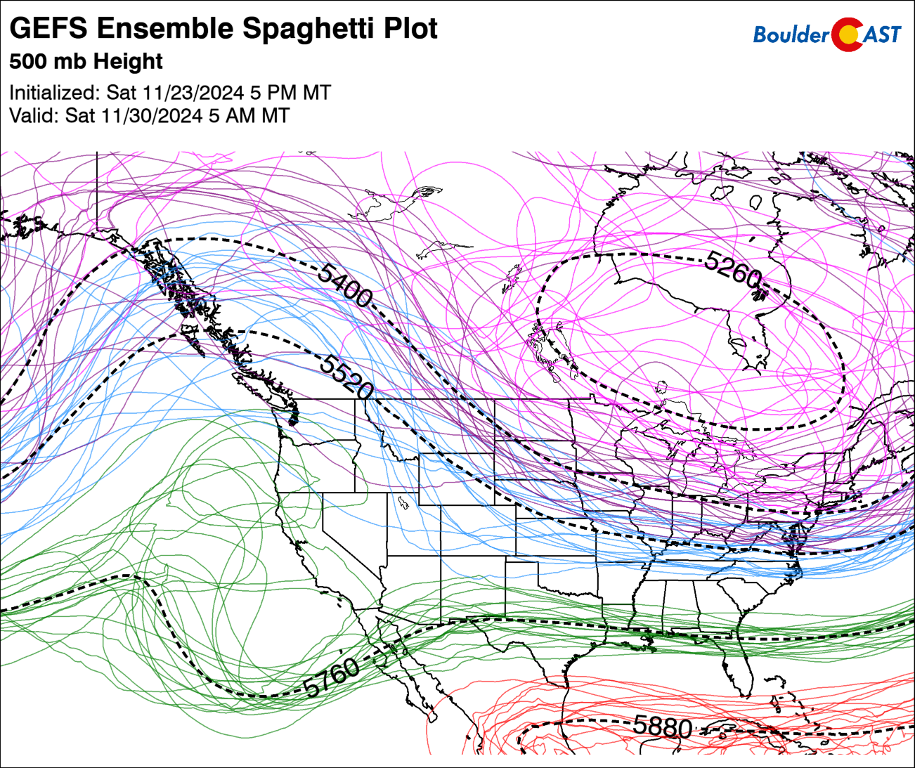
Regardless of what happens on Wednesday, models are in much better agreement that Thursday will be quiet for Thanksgiving Day. It will be cold with highs in the upper 30s, but sunshine will be prevalent. There could still be some lingering travel impacts from the heavy snow in the High Country. As for Friday and the weekend, uncertainty returns. A strong northerly jet stream is forecast to penetrate southward into the Mid-Mississippi Valley, with ridging setting up. over the Pacific Northwest. This pattern is largely dictated by a positive PNA (Pacific North American) pattern and a negative NAO (North Atlantic Oscillation) pattern.
The aforementioned setup typically favors prolonged cold air over the central to eastern United States, as well as possible Arctic Air intrusions. Arctic air is forecast to edge southward into Montana and the northern Great Plains late this week and weekend ahead. The 800mb temperature forecast below is for Saturday morning.
As for eastern Colorado, it looks like we will be on the far western fringe of this Arctic air. A look at the GEFS shows the troughing over the eastern portions of Canada and ridging over the Pacific Northwest, a classic positive PNA and negative NAO setup for cold Arctic air over the eastern US. Whether some of that Arctic air actually reaches eastern Colorado is not known just yet — though it’s not looking good right now for this cold air to reach us. After highs on Friday in the lower 40s, our weekend temperatures are less certain, ranging from the low 30s to mid/upper 40s. Guidance is also is mixed on a possible Friday-Saturday system in the flow, but for right now its too uncertain to forecast any snow chances at this point.
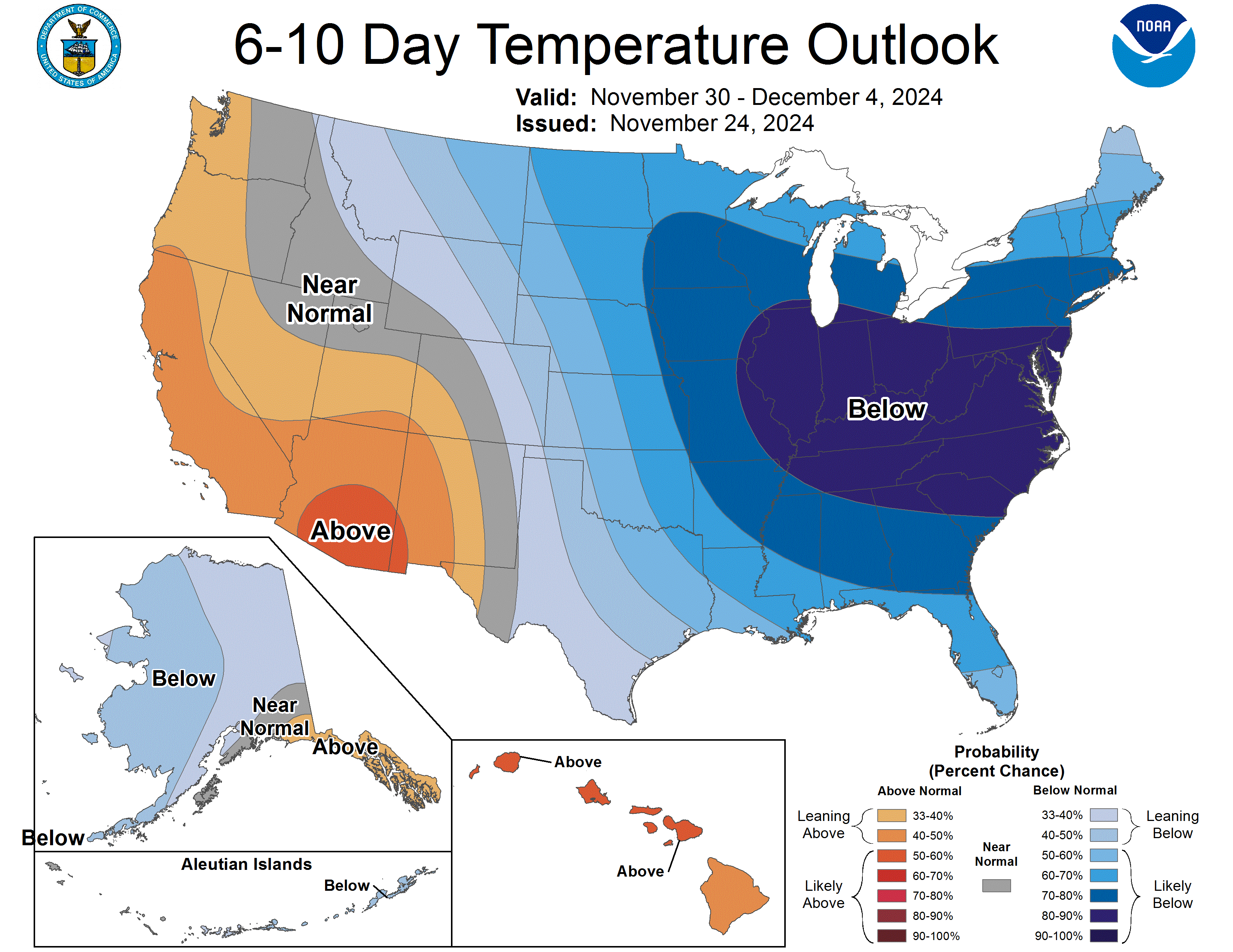
The Climate Prediction Center’s 6-10 day outlook favors below normal temperatures from the Midwest into the Mid-Atlantic this weekend into the first week of December. Note how eastern Colorado is just on the edge of this coldest air. Time will tell, but for now it looks like we may be spared…
Overall, this week will be chilly but largely dry for the Metro area, with the exception of course being the tricky rain to snow forecast developing for Tuesday evening into Wednesday…
From the entire BoulderCAST team, we wish you a safe and joyous Thanksgiving with your friends and family alike!
Forecast Specifics:
Monday: Sunny skies and chilly. Highs in the mid to upper 40s on the Plains and mid 30s in the Foothills.
Tuesday: Mostly sunny early, then becoming cloudy with rain showers in the evening eventually turning to snow Tuesday night. Highs a little more mild in the low 50s on the Plains and low 40s in the Foothills.
Wednesday: Light to moderate snow for the Plains and Foothills during the morning, with snow tapering off by afternoon or early evening. Highs in the mid to upper 30s for the Plains and upper 20s in the Foothills. Exact snowfall amounts remain uncertain, but they are expected to be light (less than 6″).
Thanksgiving Day: Beautiful with lots of sunshine for Turkey Day. Highs stay chilly for Thanksgiving in the upper 30s in the Denver Metro and upper 20s in the Foothills.
Friday: Partly to mostly sunny with highs in the lower to middle 40s for the Plains and low 30s in the Foothills.
Weekend: Most likely a dry weekend. Temperatures are uncertain, depending on a possible intrusion of Arctic Air, with highs ranging from the low 30s to mid/upper 40s. Right now we are leaning towards the warmer end of this range.
Get BoulderCAST updates delivered to your inbox:
DISCLAIMER: This weekly outlook forecast is created Monday morning and covers the entire upcoming week. Accuracy will decrease as the week progresses as this post is NOT updated. To receive daily updated forecasts from our team, among many other perks, subscribe to BoulderCAST Premium.
Daily Forecast Updates
Get our daily forecast discussion every morning delivered to your inbox.
All Our Model Data
Access to all our Colorado-centric high-resolution weather model graphics. Seriously — every one!
Ski & Hiking Forecasts
6-day forecasts for all the Colorado ski resorts, plus more than 120 hiking trails, including every 14er.
Smoke Forecasts
Wildfire smoke concentration predictions up to 72 hours into the future.
Exclusive Content
Weekend outlooks every Thursday, bonus storm updates, historical data and much more!
No Advertisements
Enjoy ad-free viewing on the entire site.
Enjoy our content? Give it a share!





You must be logged in to post a comment.