Get ready for a preview of summer! Near-record heat will kick off the week across the Front Range, with highs soaring towards the mid to upper 80s. These temperatures could tie or break existing records, making for a sizzling start to the week. But don’t worry—relief is already on the way! A mostly dry cold front will roll through around midweek, cooling things down to more seasonable levels. While a few stray showers might pop up later in the week, the better chance for wet weather arrives over the upcoming weekend.
This week’s highlights include:
- Summerlike weekend: The region enjoyed sunny skies and warm temperatures in the 70s and 80s this past weekend, creating an early-summer feel. Recent rainfall has turned the Front Range green.
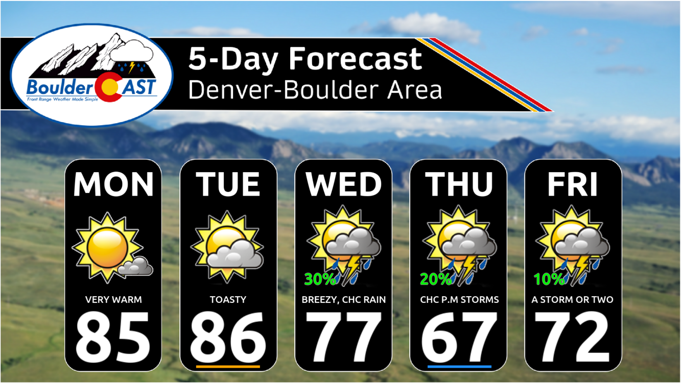
- Near-record heat: High-pressure ridging will bring well-above-average temperatures Monday and Tuesday, with Boulder’s record highs (88°F and 89°F) possibly being challenged.
- Midweek cooldown: A trough will move through Wednesday, bringing a cold front. While Wednesday will still be warm, highs will dip into the upper 60s to low 70s by Thursday.
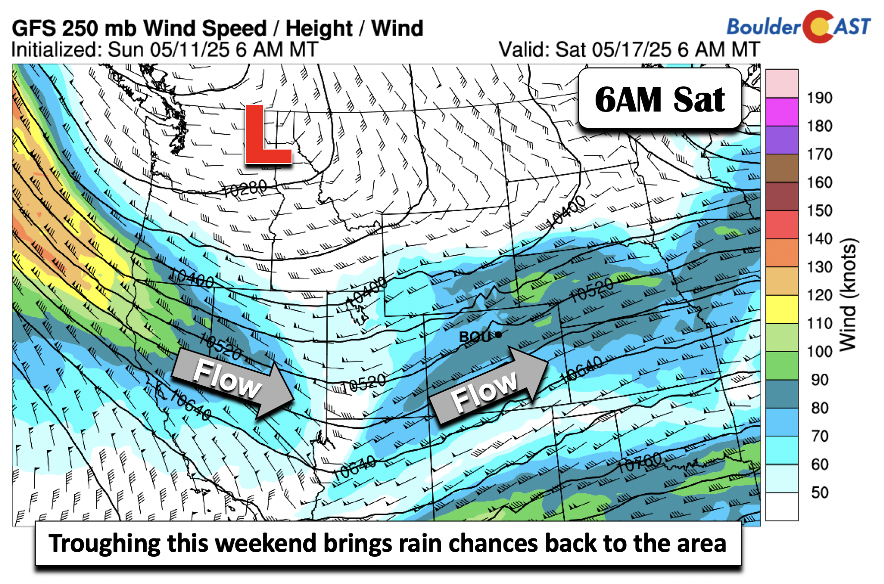
- Rain potential: Our best chance of rain will accompany the cold front late in the day Wednesday. Lingering weak instability may produce isolated showers Thursday and Friday, with a better chance of showers over the weekend as a another trough shifts eastward.
DISCLAIMER: This weekly outlook forecast is created Monday morning and covers the entire upcoming week. Accuracy will decrease as the week progresses as this post is NOT updated. To receive daily updated forecasts from our team, among many other perks, subscribe to BoulderCAST Premium.

Go Premium, get all the perks.
Daily Forecast Updates
Get our daily forecast discussion every morning delivered to your inbox.
All Our Model Data
Access to all our Colorado-centric high-resolution weather model graphics. Seriously — every one!
Ski & Hiking Forecasts
6-day forecasts for all the Colorado ski resorts, plus more than 120 hiking trails, including every 14er.
Smoke Forecasts
Wildfire smoke concentration predictions up to 72 hours into the future.
Exclusive Content
Weekend outlooks every Thursday, bonus storm updates, historical data and much more!
No Advertisements
Enjoy ad-free viewing on the entire site.
Near-record heat early in the week
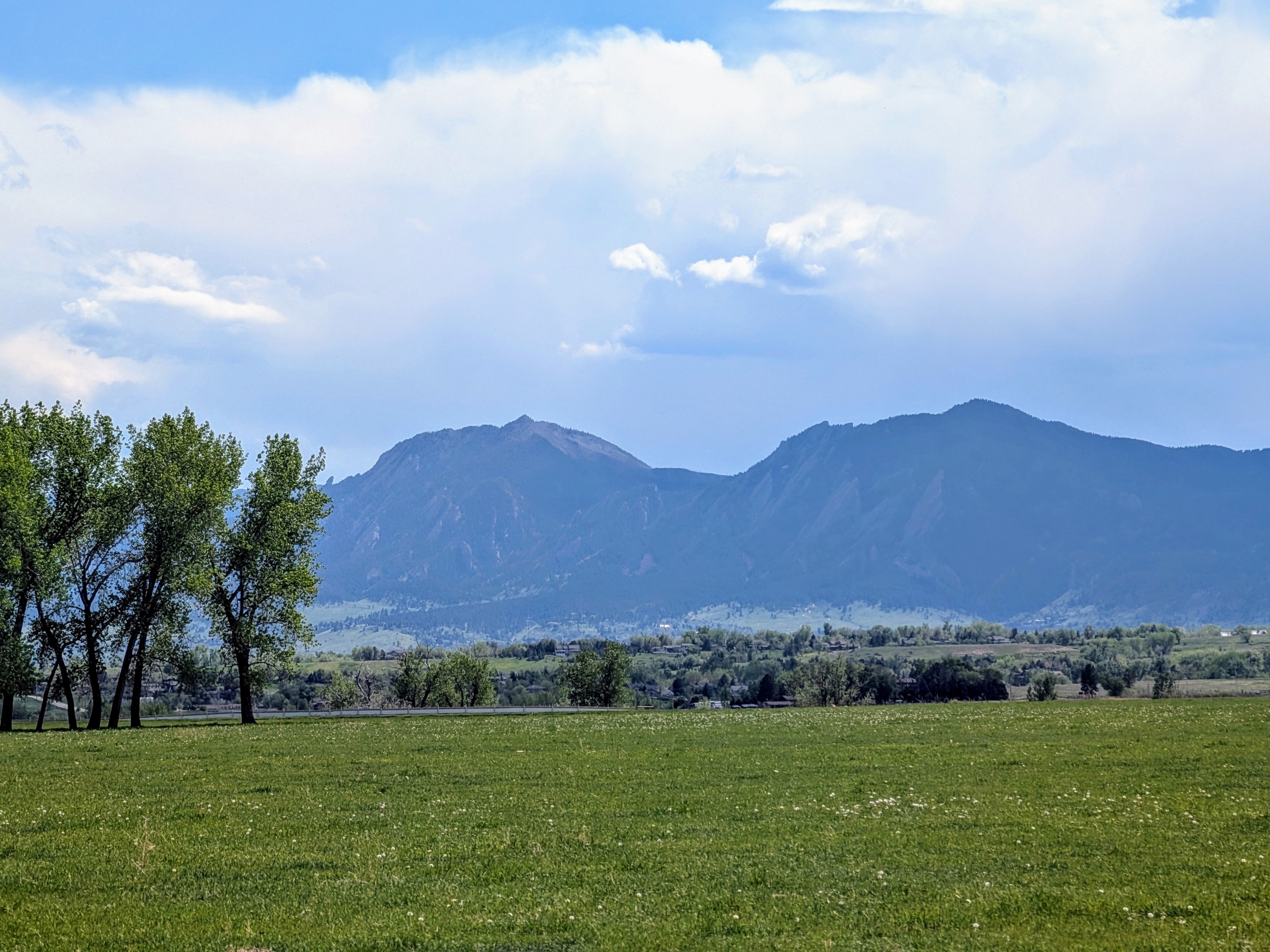
The Front Range has transformed into a lush green landscape after nearly two inches of rainfall last week, offering a refreshing change from our usual brown hues. This was the emerald scene in Boulder yesterday:
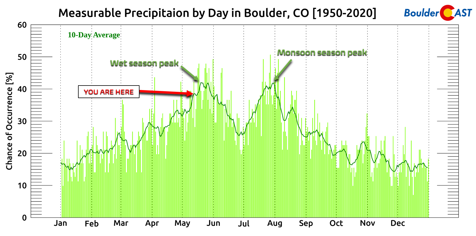
This past weekend brought beautiful weather across the region, with mostly sunny skies and temperatures soaring into the 70s and 80s. It was the first weekend that truly felt like summer—perhaps a bit premature for early May, but we can only play the cards we’re dealt. We are now entering the peak of our (first) wet season of the year. And yes, we do have some rain to discuss in this week’s forecast.
The workweek kicks off with more summerlike conditions, including a few days of near-record warmth. High-pressure ridging will remain firmly in place over the area through Monday and Tuesday, setting the stage for well-above-average temperatures. Meanwhile, a trough developing over the Pacific Northwest will begin influencing our weather by midweek.
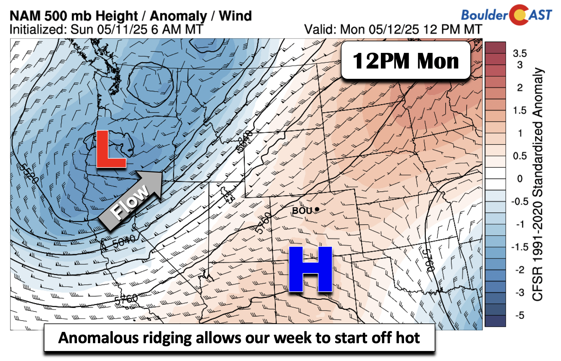
Heat will peak through Tuesday, with Boulder’s record highs—88°F on Monday and 89°F on Tuesday—at risk of being broken, as forecasts call for mid-to-upper 80s both days.

Cooling off behind a midweek cold front
The aforementioned trough to our west early in the week will track through late in the day Wednesday. Strong lift and energy will overspread the state. However, much of the flow will be westerly across the Front Range, favoring the best shower and storm chances across the higher terrain.
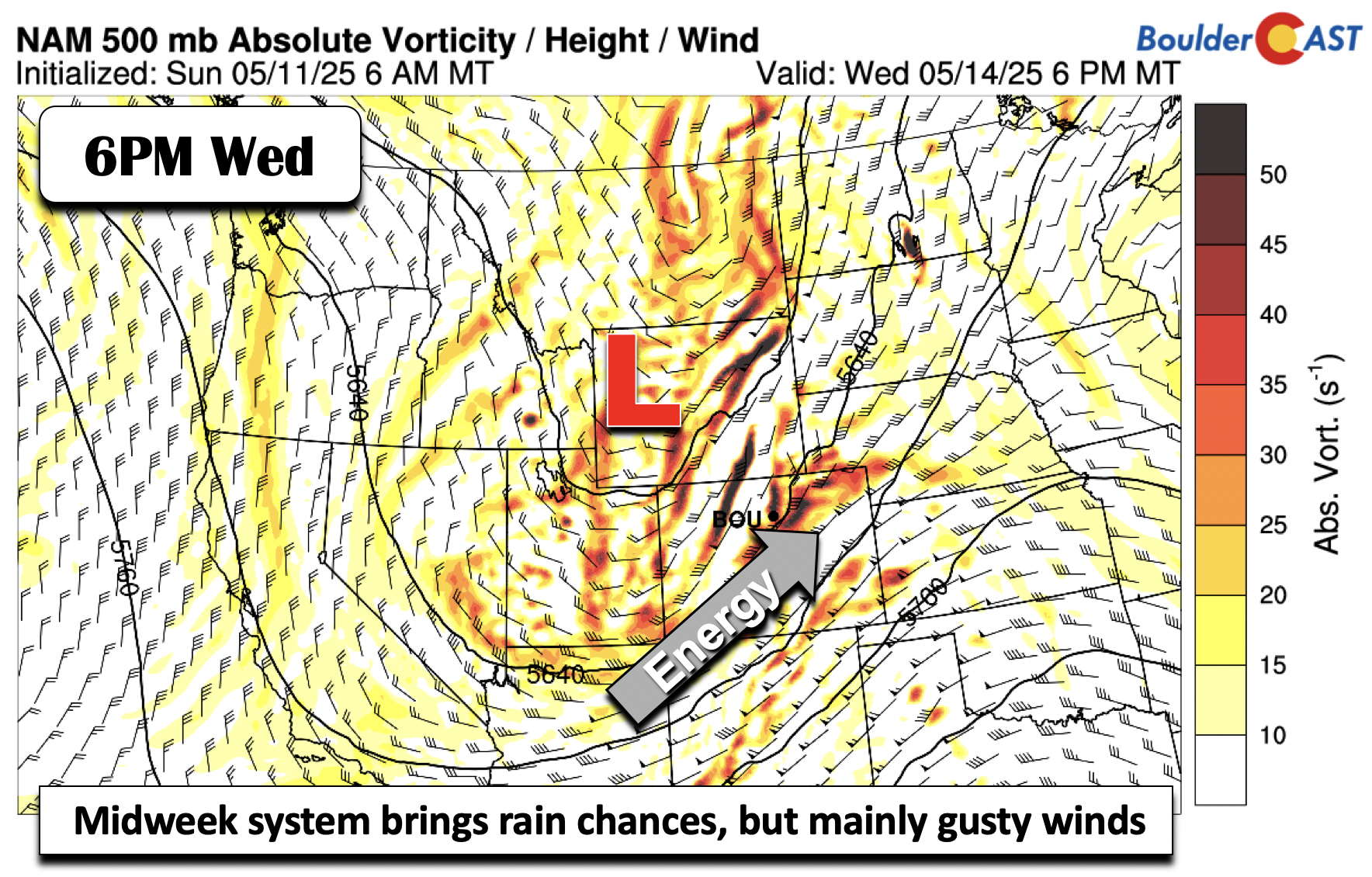
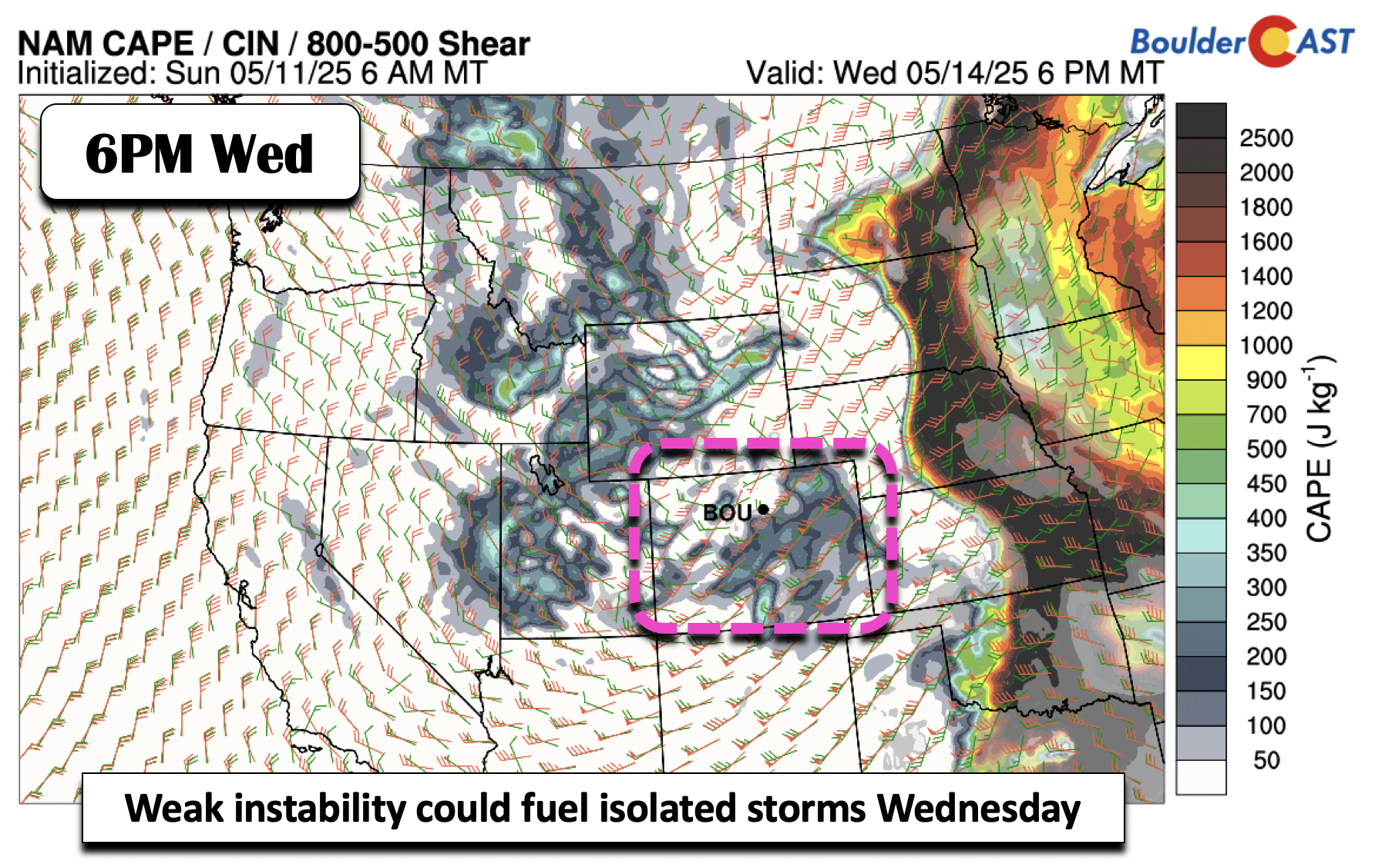
A cold front will sweep through on Wednesday, though its strongest cooling effects won’t be fully felt until Wednesday night into Thursday. While Wednesday’s highs will dip slightly into the 70s, conditions will remain quite warm. Weak instability may spark a few isolated showers or storms over the Plains in the evening, though widespread activity is unlikely due to downslope influences. If storms do develop, strong shear could support a couple of severe cells, particularly over the far eastern parts of the state—something to monitor as we get closer.
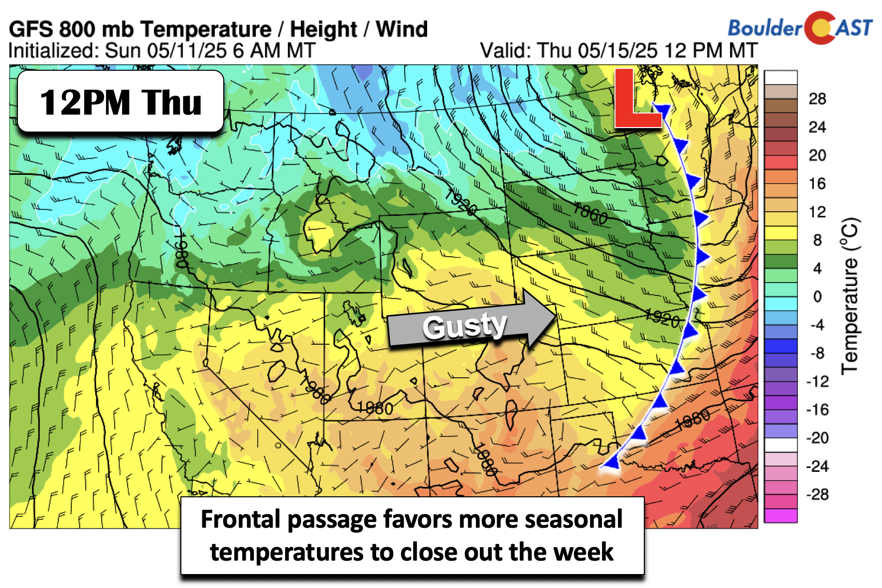
By Thursday, the front will push into the Central Plains, allowing cooler air to finally settle over the Front Range. Temperatures will return to near-seasonal averages, with highs in the upper 60s to low 70s. Westerly winds will gust between 20 and 40 mph both Wednesday and Thursday, but recent widespread rain and snow have reduced fire danger concerns for now.
A few isolated showers may develop Thursday and Friday due to lingering colder air aloft and weak instability, though dry conditions will prevail for much of the workweek. Rain chances are around 10 to 20% both days. Heading into the weekend, shower chances increase as a trough over the West Coast shifts eastward, bringing greater moisture and lift into the region. Highs are expected to remain near average in the 70s.Highs are expected to be right around average over the weekend in the 70s.
This week will be great to get outside and take in the fresh air:
Finally, for those still waiting to bring your irrigation systems online or start your gardens, the last frost of the year is likely already behind us. The median date of the last frost during ENSO-Neutral conditions, like we have in place now, is May 3rd in Boulder. Furthermore, not a single European ensemble forecast member has a sub-40°F temperature for the next 10+ days! While freezing temperatures have occurred as late as June 13th in Boulder in the past, this year we should be in the clear now. Enjoy!

Forecast Specifics:
Monday and Tuesday: Mostly sunny and hot with mid to upper 80s on the Plains and middle 70s in the Foothills.
Wednesday: Increasing clouds with a chance of afternoon and evening scattered storms. Breezy with gusts up to 40 MPH. Storm that form could produce low-end severe weather. Highs in the upper 70s on the Plains and upper 60s in the Foothills.
Thursday: Partly sunny with a chance of afternoon isolated showers and highs cooler and more seasonal in the upper 60s on the Plains and upper 50s in the Foothills. Gusty with winds up to 30 MPH.
Friday: A low-end chance of a shower or storm. Otherwise, seasonal with highs in the lower 70s on the Plains and lower 60s in the Foothills.
Weekend: Temperatures will trend slightly warmer into the 70s with better chances of showers or storms by the latter part of the weekend.
DISCLAIMER: This weekly outlook forecast is created Monday morning and covers the entire upcoming week. Accuracy will decrease as the week progresses as this post is NOT updated. To receive daily updated forecasts from our team, among many other perks, subscribe to BoulderCAST Premium.
Go Premium, get all the perks.
Daily Forecast Updates
Get our daily forecast discussion every morning delivered to your inbox.
All Our Model Data
Access to all our Colorado-centric high-resolution weather model graphics. Seriously — every one!
Ski & Hiking Forecasts
6-day forecasts for all the Colorado ski resorts, plus more than 120 hiking trails, including every 14er.
Smoke Forecasts
Wildfire smoke concentration predictions up to 72 hours into the future.
Exclusive Content
Weekend outlooks every Thursday, bonus storm updates, historical data and much more!
No Advertisements
Enjoy ad-free viewing on the entire site.
Enjoy our content? Give it a share!


You must be logged in to post a comment.