
After a rather pleasant weekend concluding with a few thundershowers Sunday night, we enter a calmer pattern for the next several days as temperatures remain above normal. We are however monitoring a southern-track storm system which may bring a return of rain and snow to the Front Range late in the week.
This week’s highlights include:
- An active subtropical jet will lead to increased cloud cover Monday and Tuesday
- Temperatures remain above normal in the 50’s to 60’s for most of the week
- A southern-track storm system cools us off Friday, brings a chance of rain and snow
DISCLAIMER: This weekly outlook forecast is created Monday morning and covers the entire upcoming week. Accuracy will decrease as the week progresses as this post is not updated. To receive daily updated forecasts from our team, subscribe to BoulderCAST Premium.

Calmer start to week
After a quarter to half an inch of rain in some portions of Denver and Boulder area last night, along with a few rumbles of thunder, we shift now into a calmer pattern.

The system which brought the energy for the rain has moved off into the Midwest. In its wake, west to east flow takes over. As evidenced below though, the subtropical jet stream remains quite active to our south (red arrow). The subtropical jet is closely tied to Pacific moisture and as of today, extends from the Eastern Pacific into Texas. Eventually this jet will bring us something to watch come Friday.

Tuesday, the subtropical jet remains active with its plume of Pacific moisture still anchored over the Desert Southwest. In the mid-levels (below), a cut-off low pressure system splits from the northern jet stream. Southwest flow ahead of this system will bring moisture and cloudiness through much of the day again tomorrow to the Front Range. Eventually, this very same system will be something to watch for Friday for a shot of wintry weather to our area? More on that later…

Tuesday should see highs in the lower 60’s. To our north on Tuesday as well, the weakened polar jet stream will be located across Montana. There is a weak trough present in this area that will push through Colorado by early Wednesday, enough to bring a meager cool front through but not do much except keep our highs pleasant in the 60’s.
Another way to look at the effect of the subtropical jet is by looking at the total atmospheric moisture content, using the precipitable water as a guide. These are shown below for Tuesday and Wednesday. The area highlighted in yellow is the region where anomalous moisture is located. Notice how all of this moisture has its origin from that low pressure system and from the Pacific Ocean. This is why we’ll start the week cloudy. By Wednesday, however, we think more sunshine will be the norm as a weak front slides through Tuesday night to bring in slightly drier air.

Thanks to more sunshine expected Wednesday, highs should push into the middle 60’s despite the cool front.
Watching late week for wintry weather
As we progress into Thursday and Friday, our dry spell looks to end with unsettled weather on the way! The aforementioned low pressure center over the Pacific earlier in the week is poised to move ashore and effect the state Friday into Saturday. However, with these types of systems weather models typically have a tough time resolving the track. We stress that things could change between now and then. As it stands currently though, a cold front advances through Thursday to drop highs back into the 50’s. However, a reinforcing shot of potentially colder air wouldn’t arrive until Friday when easterly upslope flow takes over as the system develops near the Texas panhandle (below). This track would bring in below freezing surface temperatures once again and a threat of snow. We’re still a little concerned that this storm may track too far to our south, but it certainly bears watching for now.

The ensemble forecast guidance shows a clear pattern for the Front Range to shift to unsettled weather late this week (below). There is also uncertainty on the precipitation type: will it be rain or snow? These southern systems tend to pump in warmer air overall and thus there can be less cold air to work with for snow.

All in all, we expect a more unsettled and chilly end to the week. As for the snowfall potential, it’s too early to say. Stay tuned for updates, subscribe, and enjoy what will otherwise be a mostly benign week.
Forecast Specifics:
Monday: Patchy morning fog, then partly cloudy and mild. Highs in the upper 50’s to 60 degrees on the Plains and lower 50’s in the Foothills.
Tuesday: Mostly cloudy skies with high temperatures reaching the lower 60’s on the Plains and lower 50’s in the Foothills.
Wednesday: More sunshine with highs in the middle 60’s on the Plains and middle 50’s in the Foothills.
Thursday: Increasing clouds and cooler with temperatures in the middle 50’s on the Plains and upper 40’s in the Foothills.
Friday: Cloudy with a chance of rain or snow showers. Temperatures in the 40’s on the Plains and 30’s in the Foothills.

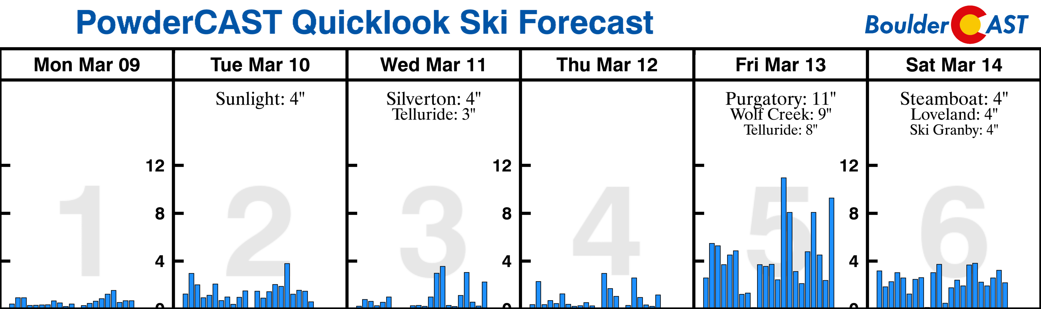
High Country: Dry weather will persist today over the higher terrain. Scattered snow showers will develop over the mountains on Tuesday with light to moderate accumulations possible. A better chance of snow exists Friday to Saturday from a southern storm track system. Check our PowderCAST page for always-updated weather forecasts for all of the Colorado ski resorts.
Help support our team of Front Range forecasters by joining BoulderCAST Premium. We talk Boulder and Denver weather every single day. Sign up now to get access to our daily forecast discussions each morning, complete six-day skiing and hiking forecasts powered by machine learning, first-class access to all our Colorado-centric high-resolution weather graphics, bonus storm updates and much more! Or not, we just appreciate your readership!
.
Spread the word, share our forecast!


You must be logged in to post a comment.